Tropical wave east of the Windward Islands (Is Invest 98L)
Moderator: S2k Moderators
Forum rules

The posts in this forum are NOT official forecasts and should not be used as such. They are just the opinion of the poster and may or may not be backed by sound meteorological data. They are NOT endorsed by any professional institution or STORM2K. For official information, please refer to products from the National Hurricane Center and National Weather Service.
-
Iceresistance

- Category 5

- Posts: 8925
- Age: 20
- Joined: Sat Oct 10, 2020 9:45 am
- Location: Tecumseh, OK/Norman, OK
Re: Tropical wave near 47W
GFS stalls this SW of New Orleans or SE of Houston, what?
0 likes
Bill 2015 & Beta 2020
Winter 2020-2021
All observations are in Tecumseh, OK unless otherwise noted.
Winter posts are focused mainly for Oklahoma & Texas.
Take any of my forecasts with a grain of salt, refer to the NWS, SPC, and NHC for official information
Never say Never with weather! Because ANYTHING is possible!
Winter 2020-2021
All observations are in Tecumseh, OK unless otherwise noted.
Winter posts are focused mainly for Oklahoma & Texas.
Take any of my forecasts with a grain of salt, refer to the NWS, SPC, and NHC for official information
Never say Never with weather! Because ANYTHING is possible!


-
ScottNAtlanta

- Category 5
- Posts: 2006
- Joined: Sat May 25, 2013 3:11 pm
- Location: Atlanta, GA
Re: Tropical wave near 47W
Current GFS has this going across the Caribbean clips the YP and heads for the TX/LA border. That is kind of suspect for this time of year. You don't get many wester GOM strikes as you get close to Oct.
0 likes
The posts in this forum are NOT official forecast and should not be used as such. They are just the opinion of the poster and may or may not be backed by sound meteorological data. They are NOT endorsed by any professional institution or storm2k.org. For official information, please refer to the NHC and NWS products.
-
AutoPenalti
- Category 5
- Posts: 3949
- Age: 27
- Joined: Mon Aug 17, 2015 4:16 pm
- Location: Ft. Lauderdale, Florida
Re: Tropical wave near 47W
Looks like it grabbed it. That trough timing will be critical.
0 likes
The posts in this forum are NOT official forecasts and should not be used as such. They are just the opinion of the poster and may or may not be backed by sound meteorological data. They are NOT endorsed by any professional institution or STORM2K. For official information, please refer to products from the NHC and NWS.
Model Runs Cheat Sheet:
GFS (5:30 AM/PM, 11:30 AM/PM)
HWRF, GFDL, UKMET, NAVGEM (6:30-8:00 AM/PM, 12:30-2:00 AM/PM)
ECMWF (1:45 AM/PM)
TCVN is a weighted averaged
-
PTrackerLA

- Category 5
- Posts: 5248
- Age: 40
- Joined: Thu Oct 10, 2002 8:40 pm
- Location: Lafayette, LA
Re: Tropical wave near 47W
Lol just stalled south of LA through 300hrs on 12z GFS as one of the largest modeled storms I've seen in the GOM.
0 likes
-
Iceresistance
- Category 5
- Posts: 8925
- Age: 20
- Joined: Sat Oct 10, 2020 9:45 am
- Location: Tecumseh, OK/Norman, OK
Re: Tropical wave near 47W
Still slams this near Houston by the end of the run.
0 likes
Bill 2015 & Beta 2020
Winter 2020-2021
All observations are in Tecumseh, OK unless otherwise noted.
Winter posts are focused mainly for Oklahoma & Texas.
Take any of my forecasts with a grain of salt, refer to the NWS, SPC, and NHC for official information
Never say Never with weather! Because ANYTHING is possible!
Winter 2020-2021
All observations are in Tecumseh, OK unless otherwise noted.
Winter posts are focused mainly for Oklahoma & Texas.
Take any of my forecasts with a grain of salt, refer to the NWS, SPC, and NHC for official information
Never say Never with weather! Because ANYTHING is possible!
Re: Tropical wave near 47W
Just south of Port Arthur, next frame is well inland. South Florida then Texas the next run. It's going to go all over, what's next?

Last edited by BobHarlem on Mon Sep 19, 2022 12:13 pm, edited 1 time in total.
0 likes
-
skyline385

- Category 5
- Posts: 2502
- Age: 33
- Joined: Wed Aug 26, 2020 11:15 pm
- Location: Houston TX
Re: Tropical wave near 47W
weeniepatrol wrote:skyline385 wrote:Iceresistance wrote:The best analog modelstorm that I can come up with right now is Delta 2020
Or Gilbert from everyone’s favorite analog year
Sent from my iPhone using Tapatalk
Gilbert didn’t form in 2013
2013 was old analog, now it’s all about 1988 with the late start.
Sent from my iPhone using Tapatalk
3 likes
-
skyline385
- Category 5
- Posts: 2502
- Age: 33
- Joined: Wed Aug 26, 2020 11:15 pm
- Location: Houston TX
Tropical wave near 47W
Such a weird end to the run, the weakness is there to pick it up but the ridge to the SE seems to be fighting with the one above Texas and stalling it.

Sent from my iPhone using Tapatalk
Sent from my iPhone using Tapatalk
0 likes
-
skyline385
- Category 5
- Posts: 2502
- Age: 33
- Joined: Wed Aug 26, 2020 11:15 pm
- Location: Houston TX
Re: Tropical wave near 47W
12Z ICON, starts developing it around 90 hours

Sent from my iPhone using Tapatalk
Sent from my iPhone using Tapatalk
0 likes
-
AutoPenalti
- Category 5
- Posts: 3949
- Age: 27
- Joined: Mon Aug 17, 2015 4:16 pm
- Location: Ft. Lauderdale, Florida
Re: Tropical wave near 47W
Just for fun.
Different set up at 240.

Different set up at 240.
0 likes
The posts in this forum are NOT official forecasts and should not be used as such. They are just the opinion of the poster and may or may not be backed by sound meteorological data. They are NOT endorsed by any professional institution or STORM2K. For official information, please refer to products from the NHC and NWS.
Model Runs Cheat Sheet:
GFS (5:30 AM/PM, 11:30 AM/PM)
HWRF, GFDL, UKMET, NAVGEM (6:30-8:00 AM/PM, 12:30-2:00 AM/PM)
ECMWF (1:45 AM/PM)
TCVN is a weighted averaged
-
SFLcane

- S2K Supporter

- Posts: 9617
- Age: 46
- Joined: Sat Jun 05, 2010 1:44 pm
- Location: Lake Worth Florida
Re: Tropical wave near 47W
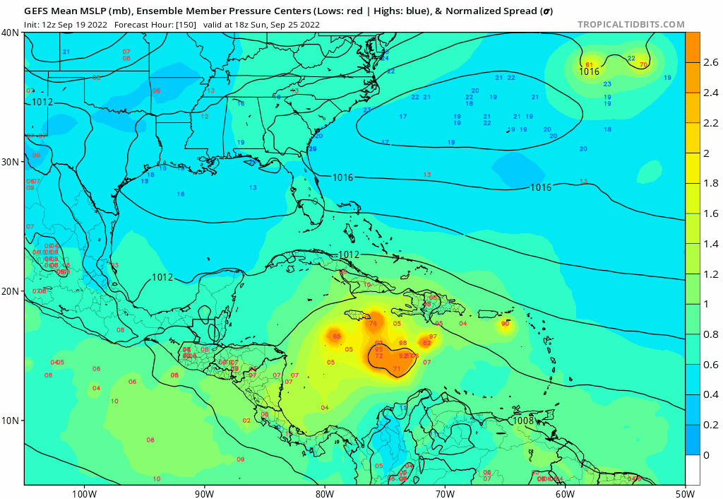
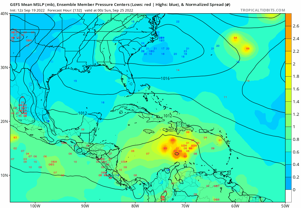
gfs will probably flip back to a florida landfall later. Good chunk of the gefs ensembles head north towards cuba and florida.

0 likes
-
toad strangler

- S2K Supporter
- Posts: 4171
- Joined: Sun Jul 28, 2013 3:09 pm
- Location: Earth
- Contact:
-
ElectricStorm

- Category 5
- Posts: 4597
- Age: 23
- Joined: Tue Aug 13, 2019 11:23 pm
- Location: Skiatook, OK / Norman, OK
Re: Tropical wave near 47W
2. Central Tropical Atlantic:
A tropical wave located several hundred miles east of the Windward
Islands is producing an area of disorganized showers and
thunderstorms. Some gradual development of this system is possible
during the next several days while the system approaches the
Windward Islands toward the end of the week and moves over the
eastern Caribbean sea over the weekend.
* Formation chance through 48 hours...low...near 0 percent.
* Formation chance through 5 days...low...20 percent.
Forecaster Roberts
9 likes
I am in no way a professional. Take what I say with a grain of salt as I could be totally wrong. Please refer to the NHC, NWS, or SPC for official information.
Boomer Sooner!
Boomer Sooner!
-
jlauderdal
- S2K Supporter
- Posts: 6776
- Joined: Wed May 19, 2004 5:46 am
- Location: NE Fort Lauderdale
- Contact:
Re: Tropical wave near 47W
SFLcane wrote:gfs will probably flip back to a florida landfall later. Good chunk of the gefs ensembles head north towards cuba and florida.
https://i.postimg.cc/jdNVTv93/gefs44.gif
GFS and Florida(especially S of Orlando) have a very special relationship
I know, all of my ripping the GFS and Florida over the last few years will come back and bite me with a major but until then, it's
considered a GFS default solution.
BTW, the rainy season finally arrived on the immediate SE coast. 6 straight days of measurable precip, thunder and lightning occurring at any time, its here. Maybe the hurricane season arrives late this year and goes late.
0 likes

Re: Tropical wave east of the Windward Islands (0/20)
Category5Kaiju wrote:Now that we have a lemon with some pretty aggressive modeling so far....
https://art.ngfiles.com/images/1315000/1315982_crispytoastyt_here-we-go.png?f1592354884
The 2022 season is off to the races, it just started a month later.
4 likes
Re: Tropical wave east of the Windward Islands (0/20)
The Euro has been active with this AEW since the 0Z 9/13 run. It even had a TS SE of the Dom. Rep. on the 0Z 9/14 run at hour 240 (see below). So, the Euro was well ahead of the GFS regarding this:

0 likes
Personal Forecast Disclaimer:
The posts in this forum are NOT official forecasts and should not be used as such. They are just the opinion of the poster and may or may not be backed by sound meteorological data. They are NOT endorsed by any professional institution or storm2k.org. For official information, please refer to the NHC and NWS products.
The posts in this forum are NOT official forecasts and should not be used as such. They are just the opinion of the poster and may or may not be backed by sound meteorological data. They are NOT endorsed by any professional institution or storm2k.org. For official information, please refer to the NHC and NWS products.
Who is online
Users browsing this forum: Cpv17, IsabelaWeather, skyline385 and 22 guests