
TAFB keeping 92L as a low moving WNW through 72 hours...
Moderator: S2k Moderators


abajan wrote:Tropical Weather Outlook
NWS National Hurricane Center Miami FL
800 AM EDT Wed Aug 16 2017 ...
A low pressure system located about 900 miles east of the Lesser Antilles continues to produce disorganized showers and a few thunderstorms. This system is moving westward at 15 to 20 mph, and it is expected to cross into the Caribbean Sea on Friday. Upper-level winds are forecast to become a little more conducive for development during the next several days, and interests in the Lesser Antilles should monitor the progress of this system.
* Formation chance through 48 hours...low...30 percent.
* Formation chance through 5 days...medium...40 percent. ...
Forecaster Berg


SoupBone wrote:abajan wrote:Tropical Weather Outlook
NWS National Hurricane Center Miami FL
800 AM EDT Wed Aug 16 2017 ...
A low pressure system located about 900 miles east of the Lesser Antilles continues to produce disorganized showers and a few thunderstorms. This system is moving westward at 15 to 20 mph, and it is expected to cross into the Caribbean Sea on Friday. Upper-level winds are forecast to become a little more conducive for development during the next several days, and interests in the Lesser Antilles should monitor the progress of this system.
* Formation chance through 48 hours...low...30 percent.
* Formation chance through 5 days...medium...40 percent. ...
Forecaster Berg
http://i.imgur.com/EdC4c1a.png
Anyone want to doubt we're entering peak season?


panamatropicwatch wrote:Kind of looks like some banding features.
Aric Dunn wrote:I bet chances go up at 2pm

Gustywind wrote:Aric Dunn wrote:I bet chances go up at 2pm
Hi Aric
So, what are your best thoughts with 91L??? Do you think that us in the Leewards could deal with a TS or "just a strong twave" ?Could you give and provides us the most interresting informations on this feature? Looks like IMO that this thing may be close to the EC this weekend even Friday too?
Thanks!
We always appreciate your bright and pertinent anwers as Caribbean friends
Dougiefresh wrote:Gustywind wrote:Aric Dunn wrote:I bet chances go up at 2pm
Hi Aric
So, what are your best thoughts with 91L??? Do you think that us in the Leewards could deal with a TS or "just a strong twave" ?
Thanks!
We always appreciate your bright and pertinent anwers as Caribbean friends
I believe we will have to deal with at least a depression before it passes though our area, upper limit of intensity... I would say maybe a weak TS
Aric Dunn wrote:Dougiefresh wrote:Gustywind wrote:Hi Aric
So, what are your best thoughts with 91L??? Do you think that us in the Leewards could deal with a TS or "just a strong twave" ?
Thanks!
We always appreciate your bright and pertinent anwers as Caribbean friends
I believe we will have to deal with at least a depression before it passes though our area, upper limit of intensity... I would say maybe a weak TS
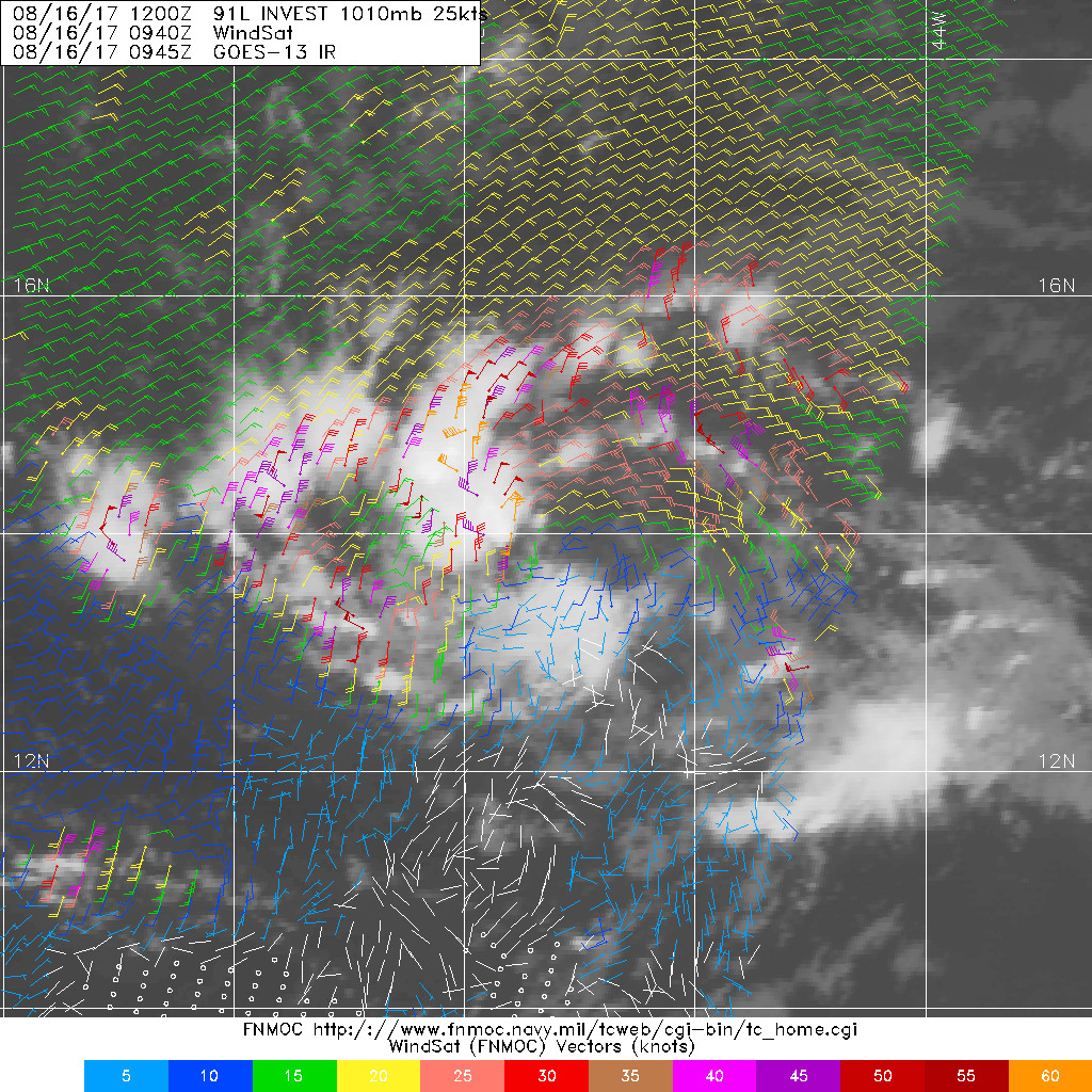
Well, it definitely has the potential to become a TS pretty quickly. last SCATT winds showed TS winds mostly due to its forward motion. The upper environment up to the eastern carrib is quite conducive. The only thing that is holding it back is the Sal but its forward speed and increasing convergence can overcome the Sal enough to become a TC. it's already pretty close just needs a little more convection near the center.
I will be back in the states next week. I have been in europe the last 2 weeks.
Aric Dunn wrote:Dougiefresh wrote:Gustywind wrote:Hi Aric
So, what are your best thoughts with 91L??? Do you think that us in the Leewards could deal with a TS or "just a strong twave" ?
Thanks!
We always appreciate your bright and pertinent anwers as Caribbean friends
I believe we will have to deal with at least a depression before it passes though our area, upper limit of intensity... I would say maybe a weak TS
Well, it definitely has the potential to become a TS pretty quickly. last SCATT winds showed TS winds mostly due to its forward motion. The upper environment up to the eastern carrib is quite conducive. The only thing that is holding it back is the Sal but its forward speed and increasing convergence can overcome the Sal enough to become a TC. it's already pretty close just needs a little more convection near the center.
I will be back in the states next week. I have been in europe the last 2 weeks.
Dougiefresh wrote:Gustywind wrote:Aric Dunn wrote:I bet chances go up at 2pm
Hi Aric
So, what are your best thoughts with 91L??? Do you think that us in the Leewards could deal with a TS or "just a strong twave" ?
Thanks!
We always appreciate your bright and pertinent anwers as Caribbean friends
I believe we will have to deal with at least a depression before it passes though our area, upper limit of intensity... I would say maybe a weak TS
Users browsing this forum: No registered users and 4 guests


