New long-term discussion from FWD NWS.
.LONG TERM... /NEW/
/Monday Night Onward/
Cold, well-below normal temperatures will persist through midweek
in the wake of our strong Arctic cold front. During the overnight
periods, low temperatures will bottom out in the low-mid 20s with
isolated spots near the Red River dipping into the upper teens.
On top of the cold air temperatures, wind chills will drop into
the teens both Tuesday and Wednesday mornings. Make sure to
continue to protect vulnerable plants and pipes as well as
bundling up for the morning commutes. The afternoon highs will
peak into the 30s and 40s on Tuesday, and the 30s region-wide on
Wednesday ahead of our next storm system. While we continue to
advertise everyone will get above freezing on Wednesday afternoon,
there continues to be a 30-40% chance that some areas north of
I-20 and west of US-281 remains below freezing all day. We`ll
continue to monitor for any increasing probabilities as we get
mid-range model data in the coming days.
Over Tuesday and Wednesday, a digging upper level trough will
move into the Desert Southwest. The southern extent of the trough
will eventually split from the main flow and amplify into a closed
cut- off low over the Mexican States of Baja California and
Sonora. While increased forcing for ascent from the low
overspreads West Texas, low-level moisture will be urged northward
on the eastern periphery of the low. This will allow for rain and
wintry precip to our west Wednesday afternoon. While there is a
low (< 15%) chance that this precipitation reaches our Big Country
and southwestern counties in the form of light sprinkles or
flurries, a very dry layer under 700mb will keep most, if not all,
precipitation from reaching the ground.
The aforementioned low will eventually weaken into an open
shortwave as it moves into the Southern Plans late this upcoming
week. Increased upper-level lift will work with the present
moisture overtop the region to promote increasing chances for rain
and wintry precipitation Wednesday night through Friday morning.
Forecast soundings continue to show at or below freezing
temperatures throughout the atmospheric column, leading to the
belief that the majority of precipitation will be in the form of
snow. However, the potential for any freezing rain across portions
of Central Texas is still uncertain at this time.. This will need
to be carefully watched as any ice accumulations could cause
greater impacts.
While we have been advertising the potential for wintry
precipitation over the last several days, the probability
continues to skyrocket. Previous ensemble and cluster analysis
featured two distinct scenarios, one of which was wetter with
winter precipitation and the second was a warmer and drier
solution with minimal winter precipitation. Yesterday, 70% of
ensemble members favored the wetter solution. Today, that
percentage is 80%, with approximately 20% of ensemble members now
outputting the drier solution. Additionally, there is now (70-80%)
high confidence of at least measurable snowfall (> 0.10") across
the majority of the region. All of this put together boosts our
confidence in the overall forecast trend, though fine-scale
details regarding exact type of precipitation, accumulation
amounts, and locations of highest snowfall still remain somewhat
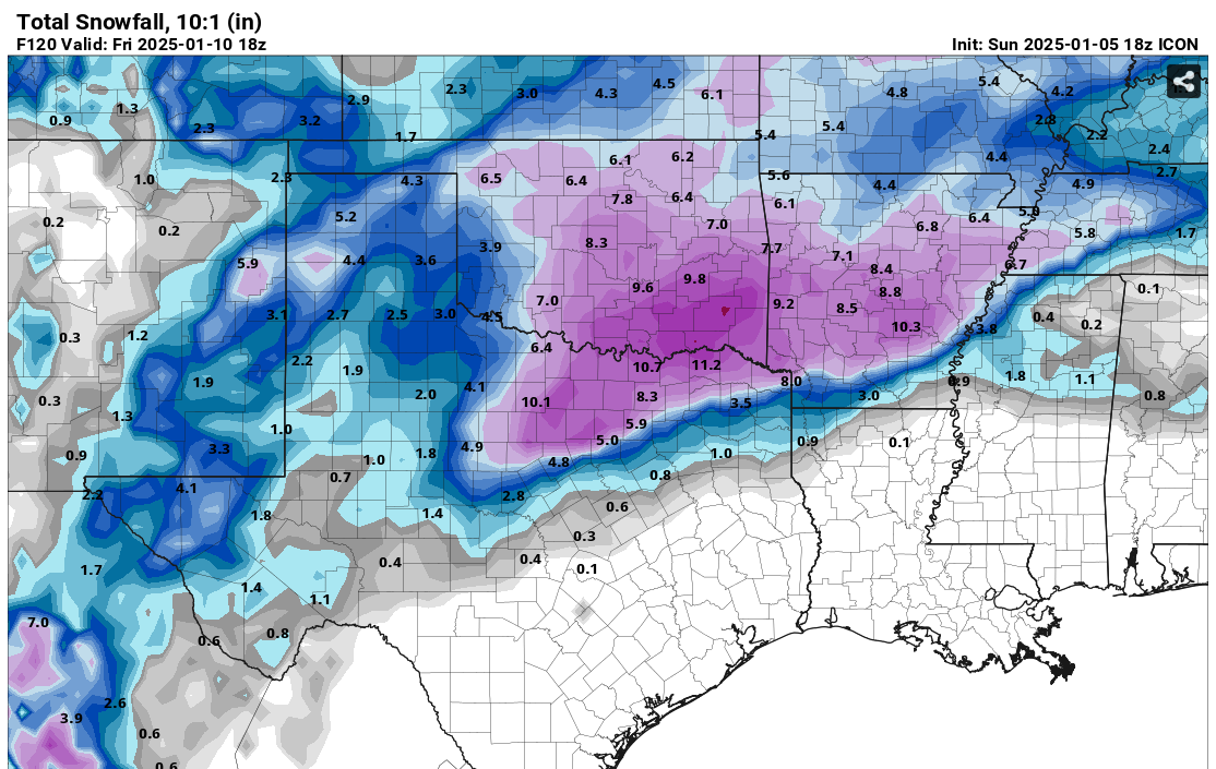
up in the air as of this forecast issuance. The current most
likely snow scenario is a widespread 1-3" of total snowfall
accumulations with isolated higher amounts Wednesday night through
Friday morning. Since we are still 5 days out and just out of the
mid- range model window, these amounts will become more refined
and will likely change as we get closer. Continue to monitor the
forecast in the coming days and start planning for winter weather
preparations.
By Friday afternoon, the rain and winter precipitation will have
ended. Over next weekend, returning southerly winds will help to
bring afternoon highs into the 40s and 50s ahead of another
potential cold front.
Prater
 The posts in this forum are NOT official forecast and should not be used as such. They are just the opinion of the poster and may or may not be backed by sound meteorological data. They are NOT endorsed by any professional institution or


