Texas winter wx thread (2009-2010)

Winter Weather Discussion

Moderator: S2k Moderators

Forum rules

The posts in this forum are NOT official forecast and should not be used as such. They are just the opinion of the poster and may or may not be backed by sound meteorological data. They are NOT endorsed by any professional institution or
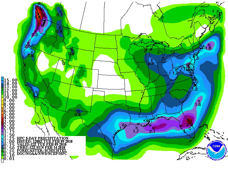
 STORM2K.

Help Support Storm2K
Message
Author
User avatar
DentonGal
Tropical Storm
Tropical Storm
Posts: 189
Joined: Sun Dec 27, 2009 6:25 am
Location: Denton, TX

Re: Texas winter wx thread (2009-2010)

#5741 Postby DentonGal » Tue Feb 09, 2010 1:11 pm

BrokenGlass wrote:
wxman57 wrote:Latest GFS runs show half to 1/3 the amount of precip for the Dallas area that earlier runs predicted. I knew that the Sunday/Monday predictions of about 0.9" liquid looked way too high for a typical west Gulf low. 12Z GFS is a lot less (0.29") liquid precip amounts in the Metroplex. That might support a few inches of wet snow. Unless something else changes, the forecast is trending away from a major snow event in Texas.
I don't like you any more.

:x


LOL! I think I just pee'd my pants!
0 likes   
Mom to 8 really is enough!

User avatar
srainhoutx
S2K Supporter
S2K Supporter
Posts: 6919
Age: 67
Joined: Sun Jan 14, 2007 11:34 am
Location: Haywood County, NC
Contact:

Re:

#5742 Postby srainhoutx » Tue Feb 09, 2010 1:21 pm

txagwxman wrote:So far ECMWF similar to the last run at 36 hours...
ECMWF very similar to the last run...snow WACO/DFW Thu....snow line close to CLL/AUS but like it a little further north...
None for Houston...bummer, but hey at least Waco/TPL/DFW/GGG/TYR get it.


Appears the EC is in the middle between the CMC and the GFS. Now on to the UKMET.
0 likes   
Carla/Alicia/Jerry(In The Eye)/Michelle/Charley/Ivan/Dennis/Katrina/Rita/Wilma/Ike/Harvey

Member: National Weather Association
Wx Infinity Forums
http://wxinfinity.com/index.php

Facebook.com/WeatherInfinity
Twitter @WeatherInfinity

User avatar
cycloneye
Admin
Admin
Posts: 145595
Age: 68
Joined: Thu Oct 10, 2002 10:54 am
Location: San Juan, Puerto Rico

Re: Texas winter wx thread (2009-2010)

#5743 Postby cycloneye » Tue Feb 09, 2010 1:25 pm

Now on to the UKMET


I dont comment on it,just posting the 12z UKMET run. :)

http://moe.met.fsu.edu/cgi-bin/ukmtc2.c ... =Animation
0 likes   
Visit the Caribbean-Central America Weather Thread where you can find at first post web cams,radars
and observations from Caribbean basin members Click Here

User avatar
srainhoutx
S2K Supporter
S2K Supporter
Posts: 6919
Age: 67
Joined: Sun Jan 14, 2007 11:34 am
Location: Haywood County, NC
Contact:

Re: Texas winter wx thread (2009-2010)

#5744 Postby srainhoutx » Tue Feb 09, 2010 1:29 pm

cycloneye wrote:
Now on to the UKMET


I dont comment on it,just posting the 12z UKMET. :)

http://moe.met.fsu.edu/cgi-bin/ukmtc2.c ... =Animation


Thanks Luis! :wink: Updated HPC 5 Day QPF Totals...

Image
0 likes   
Carla/Alicia/Jerry(In The Eye)/Michelle/Charley/Ivan/Dennis/Katrina/Rita/Wilma/Ike/Harvey

Member: National Weather Association
Wx Infinity Forums
http://wxinfinity.com/index.php

Facebook.com/WeatherInfinity
Twitter @WeatherInfinity

User avatar
srainhoutx
S2K Supporter
S2K Supporter
Posts: 6919
Age: 67
Joined: Sun Jan 14, 2007 11:34 am
Location: Haywood County, NC
Contact:

Re: Texas winter wx thread (2009-2010)

#5745 Postby srainhoutx » Tue Feb 09, 2010 1:45 pm

HPC Model Peference...hmmm...

...SYSTEM INITIALLY NEAR THE CALIFORNIA COAST...

PREFERENCE: ECMWF/UKMET/CMC COMPROMISE

THE NAM BECOMES A SLOW OUTLIER WITH THE UPR LOW COMPARED TO THE
GFS AND MAJORITY OTHER SOLNS FROM TUE NIGHT ONWARD. SOME 09Z
SREF/06-12Z GEFS MEMBERS DO OFFER POTENTIAL FOR THE SLOWER TIMING
THOUGH. THE NAM HAS YET TO DISPLAY A TREND TOWARD THE MAJORITY
FASTER SOLN BUT GIVEN A TYPICALLY SLOW BIAS WHEN THE NAM IS ON THE
SLOW EDGE OF THE GUIDANCE SPREAD... WOULD FAVOR LEANING AWAY FROM
THE NAM WITH THE UPR SYSTEM AND EVENTUALLY THE SFC LOW THAT TRACKS
OVER THE GULF. AMONG THE NON-NAM GUIDANCE THE GFS BECOMES MORE
SUPPRESSED WITH THE GULF SFC LOW THAN MOST SOLNS ASIDE FROM THE
06-12Z GEFS MEANS... WHILE THE ECMWF/UKMET/CMC AND 00Z ECMWF
ENSEMBLE MEAN SHOW FASTER TIMING THAN THE GFS. THE
UKMET/CMC/ECMWF ARE ALL SOMEWHAT DEEPER THAN THE GFS WITH THE CORE
OF THE SHRTWV ALOFT BY LATE FRI. OVERALL THE GFS FCST APPEARS
BETTER THAN THE NAM... BUT GFS FLOW FROM THE PLAINS TO APLCHNS BY
LATE IN THE FCST IS NOT THE MOST PREFERRED. AS THE 12Z ECMWF
MAINTAINS GOOD CONTINUITY WITH ITS PREVIOUS RUN... WILL ULTIMATELY
RECOMMEND A COMPROMISE AMONG THE ECMWF/UKMET/CMC WHICH TRACK THE
GULF OF MEXICO SFC LOW FARTHER NWD THAN THE GFS.
0 likes   
Carla/Alicia/Jerry(In The Eye)/Michelle/Charley/Ivan/Dennis/Katrina/Rita/Wilma/Ike/Harvey

Member: National Weather Association
Wx Infinity Forums
http://wxinfinity.com/index.php

Facebook.com/WeatherInfinity
Twitter @WeatherInfinity

User avatar
srainhoutx
S2K Supporter
S2K Supporter
Posts: 6919
Age: 67
Joined: Sun Jan 14, 2007 11:34 am
Location: Haywood County, NC
Contact:

Re: Texas winter wx thread (2009-2010)

#5746 Postby srainhoutx » Tue Feb 09, 2010 2:12 pm

I would love to be a 'fly on the wall' in the conference call between the HPC and the TX NWS offices today. :cheesy:
0 likes   
Carla/Alicia/Jerry(In The Eye)/Michelle/Charley/Ivan/Dennis/Katrina/Rita/Wilma/Ike/Harvey

Member: National Weather Association
Wx Infinity Forums
http://wxinfinity.com/index.php

Facebook.com/WeatherInfinity
Twitter @WeatherInfinity

WacoWx
Category 2
Category 2
Posts: 664
Joined: Mon Dec 28, 2009 4:14 pm
Location: NOT Waco, TX ----> Dallas, TX

Re:

#5747 Postby WacoWx » Tue Feb 09, 2010 2:16 pm

txagwxman wrote:So far ECMWF similar to the last run at 36 hours...
ECMWF very similar to the last run...snow WACO/DFW Thu....snow line close to CLL/AUS but like it a little further north...
None for Houston...bummer, but hey at least Waco/TPL/DFW/GGG/TYR get it.


I assume CLL is College Station? If so, I want to believe the above statement so hard. still having a hard time believing we're going to be cold enough here for froven precip but thats just my pessimism keeping me grounded.
0 likes   

User avatar
Big O
Category 1
Category 1
Posts: 252
Age: 55
Joined: Sun Sep 16, 2007 4:40 pm
Location: McAllen, Texas

Re: Texas winter wx thread (2009-2010)

#5748 Postby Big O » Tue Feb 09, 2010 2:21 pm

The 12z run of the European/ECMWF appears to show a surge of very cold air into the eastern 2/3 of the CONUS during days 7-10. I can't tell whether the STJ will eject any disturbances across Texas during this time frame. However, it appears to be increasingly probable that the pattern is retrograding with the trough becoming centered across the central and eastern US as opposed to just the eastern US. This is also supported by the European weeklies which show much below normal temperature anomalies across the eastern 2/3 of the US during weeks 1-4.

Anyone have any thoughts about precipitation possibilities during this time frame (days 7-10)?
0 likes   

User avatar
vbhoutex
Storm2k Executive
Storm2k Executive
Posts: 29113
Age: 73
Joined: Wed Oct 09, 2002 11:31 pm
Location: Cypress, TX
Contact:

Re: Texas winter wx thread (2009-2010)

#5749 Postby vbhoutex » Tue Feb 09, 2010 2:23 pm

srainhoutx wrote:I would love to be a 'fly on the wall' in the conference call between the HPC and the TX NWS offices today. :cheesy:

That could be very interesting to say the least!!
0 likes   
Skywarn, C.E.R.T.
Please click below to donate to STORM2K to help with the expenses of keeping the site going:
Image

User avatar
gboudx
S2K Supporter
S2K Supporter
Posts: 4080
Joined: Thu Sep 04, 2003 1:39 pm
Location: Rockwall, Tx but from Harvey, La

#5750 Postby gboudx » Tue Feb 09, 2010 2:24 pm

Not sure what it means, if anything, but the SWS for the DFW area is no longer showing as active for the area. Maybe an upgrade?
0 likes   

User avatar
Ntxw
Storm2k Moderator
Storm2k Moderator
Posts: 22790
Joined: Wed Oct 21, 2009 6:34 pm
Location: DFW, Texas

Re:

#5751 Postby Ntxw » Tue Feb 09, 2010 2:34 pm

gboudx wrote:Not sure what it means, if anything, but the SWS for the DFW area is no longer showing as active for the area. Maybe an upgrade?


Is now a hazardous weather outlook.

THIS HAZARDOUS WEATHER OUTLOOK IS FOR NORTH TEXAS.

.DAY ONE...TODAY AND TONIGHT.

WIND CHILL READINGS IN THE TEENS CAN BE EXPECTED THIS MORNING
ACROSS MOST OF NORTH TEXAS.

.DAYS TWO THROUGH SEVEN...WEDNESDAY THROUGH MONDAY.

ACCUMULATING SNOWFALL BETWEEN 1 AND 3 INCHES IS POSSIBLE NORTH OF
A KILLEEN...WACO...ATHENS LINE THURSDAY AND THURSDAY NIGHT. A
WINTRY MIX IS POSSIBLE FURTHER SOUTH. THE SNOW AND WINTRY MIX WILL
LIKELY RESULT IN SOME TRAVEL IMPACTS ACROSS THE REGION...ESPECIALLY
THURSDAY NIGHT WHEN TEMPERATURES FALL BELOW FREEZING.
0 likes   
The above post and any post by Ntxw is NOT an official forecast and should not be used as such. It is just the opinion of the poster and may or may not be backed by sound meteorological data. It is NOT endorsed by any professional institution including Storm2k. For official information, please refer to NWS products.

  Help support Storm2K!
Help Support Storm2K

User avatar
srainhoutx
S2K Supporter
S2K Supporter
Posts: 6919
Age: 67
Joined: Sun Jan 14, 2007 11:34 am
Location: Haywood County, NC
Contact:

Re: Texas winter wx thread (2009-2010)

#5752 Postby srainhoutx » Tue Feb 09, 2010 2:35 pm

Big O wrote:The 12z run of the European/ECMWF appears to show a surge of very cold air into the eastern 2/3 of the CONUS during days 7-10. I can't tell whether the STJ will eject any disturbances across Texas during this time frame. However, it appears to be increasingly probable that the pattern is retrograding with the trough becoming centered across the central and eastern US as opposed to just the eastern US. This is also supported by the European weeklies which show much below normal temperature anomalies across the eastern 2/3 of the US during weeks 1-4.

Anyone have any thoughts about precipitation possibilities during this time frame (days 7-10)?


The only thing that concerns me is that the STJ will shift S as the trough deepens. With that said it does open the door to a NW flow and we have seen disturbances rotate S during this type of setup (see what's happening today in the Midwest). Bears watching IMHO.
0 likes   
Carla/Alicia/Jerry(In The Eye)/Michelle/Charley/Ivan/Dennis/Katrina/Rita/Wilma/Ike/Harvey

Member: National Weather Association
Wx Infinity Forums
http://wxinfinity.com/index.php

Facebook.com/WeatherInfinity
Twitter @WeatherInfinity

User avatar
gboudx
S2K Supporter
S2K Supporter
Posts: 4080
Joined: Thu Sep 04, 2003 1:39 pm
Location: Rockwall, Tx but from Harvey, La

Re: Re:

#5753 Postby gboudx » Tue Feb 09, 2010 2:40 pm

Ntxw wrote:
gboudx wrote:Not sure what it means, if anything, but the SWS for the DFW area is no longer showing as active for the area. Maybe an upgrade?


Is now a hazardous weather outlook.


Yeah I saw that. But I just checked again and now the HWO is gone too. Hmmm.....
0 likes   

DFW Stormwatcher
Tropical Storm
Tropical Storm
Posts: 240
Age: 54
Joined: Sun Dec 27, 2009 10:35 pm
Location: Keller, Tx

Re: Texas winter wx thread (2009-2010)

#5754 Postby DFW Stormwatcher » Tue Feb 09, 2010 2:52 pm

Yea, it's weird that they posted that HWO at 1:36 and it's not there 15 minutes later.
0 likes   
Disclaimer: This is not an official weather forecast. I am only an amateur weather enthusiast therefore any weather forecasts or opinions should be taken with a grain of salt. Hook em Horns!

Weatherdude20

Re: Texas winter wx thread (2009-2010)

#5755 Postby Weatherdude20 » Tue Feb 09, 2010 2:53 pm

:ggreen: :ggreen: :ggreen: :ggreen:
0 likes   

User avatar
Portastorm
Storm2k Moderator
Storm2k Moderator
Posts: 9914
Age: 63
Joined: Fri Jul 11, 2003 9:16 am
Location: Round Rock, TX
Contact:

Re: Texas winter wx thread (2009-2010)

#5756 Postby Portastorm » Tue Feb 09, 2010 2:54 pm

OK ... it's time to speculate. So if HPC is right and a blend of the Euro/Canadian/UKMET is the way to go, then that means the surface low developing in the Gulf will be further north than what the GFS suggests. That could mean more precip further inland IIRC what Wxman57 posted yesterday or the day before about parameters for this event.

But in terms of real weather, I wonder what that model blend means. Maybe less aggresive warm air advection? I haven't looked upstream either to see what the Euro and CMC progged as strength of the high ... to see if maybe our surface temps would be a bit lower (or higher) than what the GFS suggests.

Anyone have ideas?
0 likes   

User avatar
gboudx
S2K Supporter
S2K Supporter
Posts: 4080
Joined: Thu Sep 04, 2003 1:39 pm
Location: Rockwall, Tx but from Harvey, La

Re: Texas winter wx thread (2009-2010)

#5757 Postby gboudx » Tue Feb 09, 2010 2:54 pm

Weatherdude20 wrote::ggreen: :ggreen: :ggreen: :ggreen:


What do you know? Spill it. :D
0 likes   

HockeyTx82
S2K Supporter
S2K Supporter
Posts: 2540
Joined: Tue Oct 27, 2009 11:17 am
Location: Ponder, TX

Re: Texas winter wx thread (2009-2010)

#5758 Postby HockeyTx82 » Tue Feb 09, 2010 2:56 pm

DFW Stormwatcher wrote:Yea, it's weird that they posted that HWO at 1:36 and it's not there 15 minutes later.


I was just about to post the same thing. Something is going on............. :double:
0 likes   
Don't hold me accountable for anything I post on this forum. Leave the real forecasting up to the professionals.

Location: Ponder, TX (all observation posts are this location unless otherwise noted)

User avatar
srainhoutx
S2K Supporter
S2K Supporter
Posts: 6919
Age: 67
Joined: Sun Jan 14, 2007 11:34 am
Location: Haywood County, NC
Contact:

Re: Texas winter wx thread (2009-2010)

#5759 Postby srainhoutx » Tue Feb 09, 2010 2:57 pm

gboudx wrote:
Weatherdude20 wrote::ggreen: :ggreen: :ggreen: :ggreen:


What do you know? Spill it. :D


Image
0 likes   
Carla/Alicia/Jerry(In The Eye)/Michelle/Charley/Ivan/Dennis/Katrina/Rita/Wilma/Ike/Harvey

Member: National Weather Association
Wx Infinity Forums
http://wxinfinity.com/index.php

Facebook.com/WeatherInfinity
Twitter @WeatherInfinity

HockeyTx82
S2K Supporter
S2K Supporter
Posts: 2540
Joined: Tue Oct 27, 2009 11:17 am
Location: Ponder, TX

Re: Texas winter wx thread (2009-2010)

#5760 Postby HockeyTx82 » Tue Feb 09, 2010 2:59 pm

:uarrow: :uarrow: :uarrow:

That does not look anything like the map from yesterday, I don't like it. Take it away..............
0 likes   
Don't hold me accountable for anything I post on this forum. Leave the real forecasting up to the professionals.

Location: Ponder, TX (all observation posts are this location unless otherwise noted)


Return to “Winter Weather”

Who is online

Users browsing this forum: No registered users and 54 guests