The posts in this forum are NOT official forecast and should not be used as such. They are just the opinion of the poster and may or may not be backed by sound meteorological data. They are NOT endorsed by any professional institution or

However, at this time, I would not yet write off the prospect of at least some precipitation, including snow, affecting the East Coast early next week via closer storm development and a closer track.
∙ The East is now in a stormy pattern. Precipitation amounts have increased dramatically over the past 10-15 days, particularly from the northern Mid-Atlantic into New England. Precipitation in the 11/15-29 period follows:
Baltimore: 2.10"
Boston: 2.16"
New York City: 3.07"
Philadelphia: 2.34"
Some of those cities have seen additional precipitation today. For now, I don't see the big changes that would lead me to abandon the idea of persistence over the medium-term.
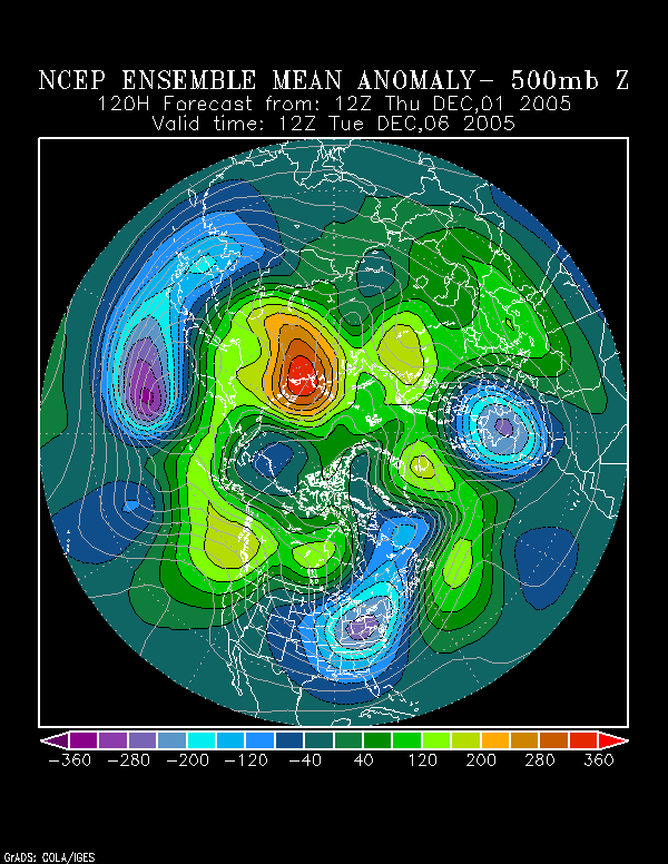
∙ The NCEP ensemble 500 mb anomalies suggest some weak ridging off the East Coast, albeit rather progressive, at 120 hours:
This might also suggest somewhat of a reduced tendency for the storm to completely miss the East Coast and perhaps development somewhat closer to the coast.
∙ The operational GFS has somewhat of a south and east bias, which may be especially prominent in December. Mount Holly's 11/30 discussion revealed:
WE BLV THE GFS NORMALLY HAS MORE THAN ITS TYPICAL SE BIAS IN DEC AND AS LONG AS ITS H2.5 JET IS OVR US...IT HAS A CHC OF PULLING PCPN FTHR TO THE N THAN EVEN IT HAS WITH THE 00Z RUN.
∙ The models have had a recent tendency to back off systems for a time. Taunton's 11/30 discussion noted:
CONFIDENCE IS NOT HIGH INTO EARLY NEXT WEEK WITH A TENDENCY FOR LATER MODEL RUNS...EXCEPT FOR THE OPERATIONAL GEM...TO BACK OFF ON A SIGNIFICANT E COAST STORM. SINCE CONFIDENCE NOT THAT HIGH FOR THAT PERIOD...HAVE NOT MADE CHANGES FOR NOW TO EXISTING FORECAST FOR DAYS 6 AND 7.
∙ Over the past week, the NAO has fallen fairly sharply. Per research by Heather Archambault, this could be a signal for an important storm in the East. So, at this time, I'd be quite leery about writing off the prospects for storminess and would err on the side of caution to expect at least some impact early next week.
∙ So far, the way I see things, in terms of the continuing pattern evolution, I would be surprised if the December 1-15 period sees no measurable snowfall from DCA to BOS. The idea of measurable snowfall (trace or above) for PHL to BOS from November 16 has worked out well, as has the idea of a return of storminess. So far, with things working out reasonably well, I continue to believe my overall pattern evolution idea remains in good shape.
The next step is whether or not early to mid-December sees snowfall in the East. I believe it will and I also believe that the cold could be sustained to at least mid-month in spite of the MJO's continuing progression courtesy of such factors as the Arctic Oscillation and NAO. A strong Arctic outbreak is possible in the period beginning late in the first week in December to shortly afterward.
Looking farther ahead, while awaiting the November data to firm things up, I am now quite confident that for the December-March period, the NAO will likely average < 0.
All said, I expect at least the first 10 days of December to continue to see storminess even as the cold increases. Coastal areas could well see measurable precipitation early next week.
The overall pattern should result in measurable snow (and in this case, more than a trace, particularly from PHL to BOS in the December 1-15 timeframe). DCA and RIC could also see measurable snow during this period.
Miller B systems might be the way to go early on, but a more suppressed storm track could develop later in the period, as the cold continus to press into the East. Whether or not a Miller A could occur during this latter period remains to be seen.
Beyond the first week in December, a generally colder-than-normal regime should prevail through at least mid-December and possibly beyond. The December 8-15 period could be especially cold, with minimum temperatures possibly falling into the teens on one or more days in the Mid-Atlantic and Northeast (from at least RIC to BOS).
Given how the pattern has evolved since November 16, my confidence in the above ideas is quite good, as they are, to some extent, an extension of the earlier ideas that have been reasonably validated to date.