Early December Storm/Pattern through Mid-December

Winter Weather Discussion

Moderator: S2k Moderators

Forum rules

The posts in this forum are NOT official forecast and should not be used as such. They are just the opinion of the poster and may or may not be backed by sound meteorological data. They are NOT endorsed by any professional institution or STORM2K.

Help Support Storm2K
Message
Author
donsutherland1
S2K Analyst
S2K Analyst
Posts: 2718
Joined: Mon Sep 15, 2003 8:49 pm
Location: New York

Early December Storm/Pattern through Mid-December

#1 Postby donsutherland1 » Wed Nov 30, 2005 10:02 am

First, as the possible early December storm continues to garner attention, it should be noted that with HPC taking a given position, that scenario is, at least, highly credible and something that needs to be considered.

However, at this time, I would not yet write off the prospect of at least some precipitation, including snow, affecting the East Coast early next week via closer storm development and a closer track.

∙ The East is now in a stormy pattern. Precipitation amounts have increased dramatically over the past 10-15 days, particularly from the northern Mid-Atlantic into New England. Precipitation in the 11/15-29 period follows:

Baltimore: 2.10"
Boston: 2.16"
New York City: 3.07"
Philadelphia: 2.34"

Some of those cities have seen additional precipitation today. For now, I don't see the big changes that would lead me to abandon the idea of persistence over the medium-term.

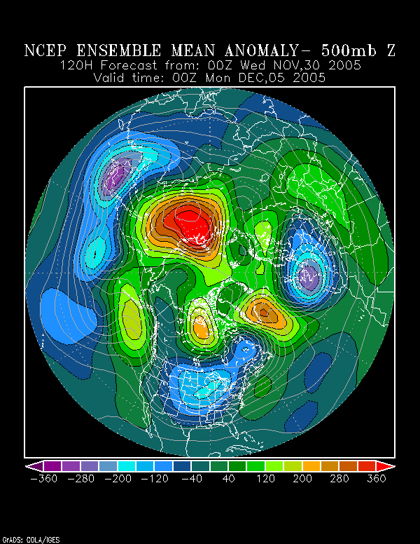
∙ The NCEP ensemble 500 mb anomalies suggest some weak ridging off the East Coast, albeit rather progressive, at 120 hours:
Image

This might also suggest somewhat of a reduced tendency for the storm to completely miss the East Coast and perhaps development somewhat closer to the coast.

∙ The operational GFS has somewhat of a south and east bias, which may be especially prominent in December. Mount Holly's 11/30 discussion revealed:

WE BLV THE GFS NORMALLY HAS MORE THAN ITS TYPICAL SE BIAS IN DEC AND AS LONG AS ITS H2.5 JET IS OVR US...IT HAS A CHC OF PULLING PCPN FTHR TO THE N THAN EVEN IT HAS WITH THE 00Z RUN.

∙ The models have had a recent tendency to back off systems for a time. Taunton's 11/30 discussion noted:

CONFIDENCE IS NOT HIGH INTO EARLY NEXT WEEK WITH A TENDENCY FOR LATER MODEL RUNS...EXCEPT FOR THE OPERATIONAL GEM...TO BACK OFF ON A SIGNIFICANT E COAST STORM. SINCE CONFIDENCE NOT THAT HIGH FOR THAT PERIOD...HAVE NOT MADE CHANGES FOR NOW TO EXISTING FORECAST FOR DAYS 6 AND 7.

∙ Over the past week, the NAO has fallen fairly sharply. Per research by Heather Archambault, this could be a signal for an important storm in the East. So, at this time, I'd be quite leery about writing off the prospects for storminess and would err on the side of caution to expect at least some impact early next week.

∙ So far, the way I see things, in terms of the continuing pattern evolution, I would be surprised if the December 1-15 period sees no measurable snowfall from DCA to BOS. The idea of measurable snowfall (trace or above) for PHL to BOS from November 16 has worked out well, as has the idea of a return of storminess. So far, with things working out reasonably well, I continue to believe my overall pattern evolution idea remains in good shape.

The next step is whether or not early to mid-December sees snowfall in the East. I believe it will and I also believe that the cold could be sustained to at least mid-month in spite of the MJO's continuing progression courtesy of such factors as the Arctic Oscillation and NAO. A strong Arctic outbreak is possible in the period beginning late in the first week in December to shortly afterward.

Looking farther ahead, while awaiting the November data to firm things up, I am now quite confident that for the December-March period, the NAO will likely average < 0.

All said, I expect at least the first 10 days of December to continue to see storminess even as the cold increases. Coastal areas could well see measurable precipitation early next week.

The overall pattern should result in measurable snow (and in this case, more than a trace, particularly from PHL to BOS in the December 1-15 timeframe). DCA and RIC could also see measurable snow during this period.

Miller B systems might be the way to go early on, but a more suppressed storm track could develop later in the period, as the cold continus to press into the East. Whether or not a Miller A could occur during this latter period remains to be seen.

Beyond the first week in December, a generally colder-than-normal regime should prevail through at least mid-December and possibly beyond. The December 8-15 period could be especially cold, with minimum temperatures possibly falling into the teens on one or more days in the Mid-Atlantic and Northeast (from at least RIC to BOS).

Given how the pattern has evolved since November 16, my confidence in the above ideas is quite good, as they are, to some extent, an extension of the earlier ideas that have been reasonably validated to date.
Last edited by donsutherland1 on Sun Dec 11, 2005 8:59 am, edited 1 time in total.
0 likes   

User avatar
Stephanie
S2K Supporter
S2K Supporter
Posts: 23843
Age: 63
Joined: Thu Feb 06, 2003 9:53 am
Location: Glassboro, NJ

#2 Postby Stephanie » Wed Nov 30, 2005 10:25 am

Great post don - as usual! :wink:

The GFS usually does tend to "drop" a storm or significantly weaken it in the medium range forecasts. There's still plenty of time to watch this develop.
0 likes   

donsutherland1
S2K Analyst
S2K Analyst
Posts: 2718
Joined: Mon Sep 15, 2003 8:49 pm
Location: New York

Re: Early December Storm/Pattern through Mid-December

#3 Postby donsutherland1 » Thu Dec 01, 2005 11:04 am

The ECMWF has continued to trend in a more favorable direction for measurable snowfall in the East for early next week. The NCEP ensemble mean anomalies are also encouraging.

In fact, the Monday-Tuesday system could well blow up into a full-fledged nor'easter. Such a storm, if it were to occur, would commence at the end of the timeframe noted in the November 16 pattern discussion per the ensemble signal consistent with Heather Archambault's research.

At this time, I believe measurable snowfall (one or more occasions) is quite likely from Baltimore to Boston. Included would be Pittsburgh, Cleveland, and the usual LES areas.

While, at least for me, it's too soon to speculate on the possibility of a significant snowfall, one should bear in mind that for NYC, a 6" or greater snowfall prior to December 10 has proved to be a strong signal for a snowy winter in the past.

Such events occurred in 1882, 1886, 1898, 1938, 1957, 2002, and 2003. Seasonal snowfall for those winters came to:

1882-83: 44.0"
1886-87: 32.9"
1898-99: 55.9"
1938-39: 37.3"
1957-58: 44.7"
2002-03: 49.3"
2003-04: 42.6"

Such events have also often signaled a snowy winter for Philadelphia, as well:

1886-87: 25.0"
1898-99: 55.4"
1938-39: 27.6"
1957-58: 41.8"
2002-03: 46.3"
2003-04: 17.8"

For areas farther north or south of the Philadelphia-NYC region or west of there, the signal has been mixed and is of little use.

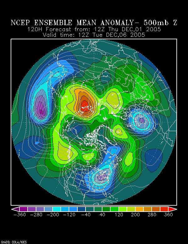
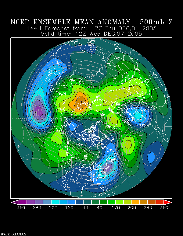
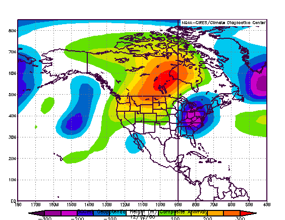
Is there some chance of such an event? 500 mb mean height anomalies (NCEP suite) hold out some hope.

120 hours:
Image

144 hours:
Image

December 12, 1960:
Image

December 13, 1960:
Image

However, it is critical to note that December 1960 featured the presence of an extremely cold air mass; that won’t be present this time around. Minimum temperatures for select cities in 1960 follow:

Code: Select all

Dec   Bos   Nyc   Phl   Dca
11   9   19   21   24
12   8   9   12   14
13   7   8   8   11


Still much colder air (1-2 standard deviations below normal/8°-12° below normal) should be not far away and should blast into the East following the storm. Hence, the storm’s track/location of probable secondary development could be crucial.

Consequently, my confidence in at least an appreciable snowfall (1” or more) from Philadelphia to Boston is high and a more significant snowfall is a genuine possibility, but I’ll wait for later guidance on that matter. Pittsburgh should do well. In fact, there’s a strong chance that Pittsburgh could surpass 6” before mid-month. Measurable snowfall in Baltimore and Washington, DC is also a possibility, but I want to see later guidance before committing to that scenario.
0 likes   

donsutherland1
S2K Analyst
S2K Analyst
Posts: 2718
Joined: Mon Sep 15, 2003 8:49 pm
Location: New York

Re: Early December Storm/Pattern through Mid-December

#4 Postby donsutherland1 » Fri Dec 02, 2005 1:11 am

At this time, I'm increasingly confident that a track ranging somewhere along the lines of those depicted on the 12/2 0z runs of the GFS, GGEM, and UKMET might be the way the Monday-Tuesday system will play out. Such a track seems quite consistent with the NCEP ensemble mean 500 mb anomalies posted Thursday morning:

Image

That would likely translate into an appreciable snowfall from at least DCA/IAD to BOS. It's still too early, at least for me, to suggest that a significant snowfall is likely, but it remains a genuine possibility.

FWIW, even as DCA was warmer than normal in November, it saw the coldest November since 2002. If DCA sees 3.0" or more snowfall in December, that could be a strong hint that the City would be headed for seasonal snowfall of 20" or more. In 7/8 (88%) years in which the November temperature came to 50.2° +/- 1° and December saw 3.0" snowfall, seasonal snowfall reached or exceeded 20" and 5/8 (63%) reached or exceeded 30". The pattern that continues to evolve could well produce 3.0" or more snowfall in DCA by mid-December. All said, 20" might be a reachable figure for DCA this winter for the first time since Winter 2002-03.
0 likes   

User avatar
brandybugg4180
Tropical Depression
Tropical Depression
Posts: 75
Joined: Sun Mar 27, 2005 3:54 am
Location: gaston, south carolina
Contact:

#5 Postby brandybugg4180 » Fri Dec 02, 2005 1:50 am

Hey Don Can u tell me anything about the southeast (south carolina mainly) winter forecast
0 likes   

donsutherland1
S2K Analyst
S2K Analyst
Posts: 2718
Joined: Mon Sep 15, 2003 8:49 pm
Location: New York

#6 Postby donsutherland1 » Fri Dec 02, 2005 10:43 am

Brandybugg4180,

For the winter as a whole, I believe South Carolina will probably see near normal readings and near normal precipitation. There will be some snowfall opportunities in at least parts of the state. With episodes of blocking, don't be surprised if there is not at least one outbreak of notable cold.
0 likes   

donsutherland1
S2K Analyst
S2K Analyst
Posts: 2718
Joined: Mon Sep 15, 2003 8:49 pm
Location: New York

#7 Postby donsutherland1 » Fri Dec 02, 2005 12:33 pm

I very much like the continuity of the 12z GFS with its earlier runs and also its fit with the overall ensemble means. At least several inches of snow (and maybe more) looks like a good bet from DCA to BOS Monday into Tuesday. RIC could join the fun, as well.

From a seasonal forecast perspective, it appears that the current pattern may well be laying the groundwork for a winter where the biggest anomalies relative to normal snowfall are south of those from last winter. That's something that showed up in the data I used for my outlook from October. This pattern might be the first hint that things remain on track.
0 likes   

donsutherland1
S2K Analyst
S2K Analyst
Posts: 2718
Joined: Mon Sep 15, 2003 8:49 pm
Location: New York

#8 Postby donsutherland1 » Fri Dec 02, 2005 5:22 pm

Early evening thoughts...

1) Continuity in competing model solutions continues: The 18z GFS remained reasonably similar to the 12z run; the 18z NAM and 12z ECMWF remained reasonably similar to their earlier runs. At this time, I continue to expect a solution closer to the GFS than the ECMWF/NAM given the GFS's continuing continuity with its runs and with the NCEP ensemble mean 500 mb height anomalies.

Therefore, Monday-Tuesday should see at least several inches of snow (and maybe more) from DCA to BOS. RIC could join the fun, as well. A more significant snowfall remains a distinct possibility.

2) Sunday event: This event should prove a nice appetizer for the Monday-Tuesday event in some places. Modest accumulations are likely from the northern Mid-Atlantic into New England. My first estimates for the Sunday (12/4) event are:

Boston: 1"-3"
Islip: 1" or less
New Haven: 1"-3"
New York City: 2" or less
Newark: 2" or less
Philadelphia: 1" or less
Pittsburgh: 1"-3"
Providence: 1"-3"
White Plains: 1"-3"
0 likes   

User avatar
Yankeegirl
Category 5
Category 5
Posts: 3417
Age: 49
Joined: Sun May 23, 2004 11:59 pm
Location: Cy-Fair, Northwest Houston
Contact:

#9 Postby Yankeegirl » Sat Dec 03, 2005 3:30 am

I love seeing the snowfall up in RI, where I am from, but what about the winter for us here in the deep south? There is quite a buzz about the cold weather for us here in Houston later on in the week..., Such as a possible snow-ice event for areas as south as Austin? What are your thoughts since the local mets dont give a forecast for more than a few days out?

Thanks!!

~YankeeGirl
0 likes   

donsutherland1
S2K Analyst
S2K Analyst
Posts: 2718
Joined: Mon Sep 15, 2003 8:49 pm
Location: New York

#10 Postby donsutherland1 » Sat Dec 03, 2005 8:28 am

YankeeGirl,

The Wednesday-Friday period should be quite cold in Austin (probably 5°-10° below normal). While some precipitation might graze the area during this time--and that would raise the risk of some snow/ice--it is just as possible that the precipitation misses. It's a close call on that issue. The cold appears all but a lock. Moderation should commence during the weekend, but the bias could remain on the cool side of the ledger through mid-month.
0 likes   

User avatar
wxwatcher91
Category 5
Category 5
Posts: 1606
Joined: Wed Jul 06, 2005 2:43 pm
Location: Keene, NH
Contact:

#11 Postby wxwatcher91 » Sat Dec 03, 2005 8:46 am

what are your thoughts on the Monday-Tuesday storm now? the models are trending further out to sea now... how are you interpreting this?
0 likes   

donsutherland1
S2K Analyst
S2K Analyst
Posts: 2718
Joined: Mon Sep 15, 2003 8:49 pm
Location: New York

#12 Postby donsutherland1 » Sat Dec 03, 2005 9:10 am

Overnight, the GFS (12/3 0z run) crossed over to the ECMWF's/NAM's "no snow" camp. However, I believe that from Richmond to Boston, it is still premature to plan the funeral for the storm that could have been.

Essentially, my thoughts remain little changed from last night: Monday-Tuesday should see at least several inches of snow from Richmond to Boston.

Such a prospect fits well with the overall synoptic pattern in place. It would be consistent with Heather Archambault's research, which often has worked out quite well.

The 0z UKMET and 6z GFS/NAM (a small step back to the snowier side) give me cautious optimism that the ultimate track will wind up bhetween those depicted by the 12/2 12z/18z GFS and 12z ECWMF (perhaps a little closer to the GFS idea).

Hence, I continue to believe my idea of several inches of snow from the Monday-Tuesday event remains reasonable. Moreover, given the uncertainty involved, I cannot rule out a more significant snowfall. But, for now, there's not enough support for such a snowier scenario. As had been the case on numerous occasions during the hurricane season, a measure of patience might be helpful as the models continue to sort out the situation.

Finally, tomorrow's event still looks on track. My estimates for that event remain as follows:

Boston: 1"-3"
Islip: 1" or less
New Haven: 1"-3"
New York City: 2" or less
Newark: 2" or less
Philadelphia: 1" or less
Pittsburgh: 1"-3"
Providence: 1"-3"
White Plains: 1"-3"
0 likes   

donsutherland1
S2K Analyst
S2K Analyst
Posts: 2718
Joined: Mon Sep 15, 2003 8:49 pm
Location: New York

Re: Early December Storm/Pattern through Mid-December

#13 Postby donsutherland1 » Sat Dec 03, 2005 1:15 pm

The models have begun to reach a consensus that brings appreciable to potentially significant snows to much of the Eastern Seaboard from Richmond to Boston.

The position of holding firmly with the idea of at least several inches of snow from Richmond to Boston in spite of the GFS' earlier defection to the consistent ECWMF-NAM alliance appears to be poised to pay dividends. Again, in my view, the emerging consensus fits better with the overall synoptic pattern than did the heartbreaking ECMWF-NAM tracks and the forthcoming 12z ECMWF is not likely to change my view even if it sticks with its suppressed solution.

During hurricane season, one saw such scenarios play out on a number of occasions. Hence, I believe the ongoing trends in the modeling and the emergent consensus are more than likely for real. All said, my confidence in a track that is between the 12/2 12z/18z GFS and 12/2 12z ECWMF, but closer to the GFS ideas is now moderate to high. The later 0z and tomorrow's 12z guidance should probably bring one fairly close to the actual solution.

Tonight or tomorrow morning, I'll probably post my first estimates for the Monday-Tuesday event. Suffice it to say, a large portion of the East Coast--from Richmond to Boston--is in the running for a plowable snowfall.
0 likes   

User avatar
wxwatcher91
Category 5
Category 5
Posts: 1606
Joined: Wed Jul 06, 2005 2:43 pm
Location: Keene, NH
Contact:

#14 Postby wxwatcher91 » Sat Dec 03, 2005 2:24 pm

What are your ideas on accumulations inland?

...say... for Keene, NH lol

on the current forecast track we would probably see a good amount less than coastal areas... however if the track shifts closer to the coast, inland areas get the brunt of the storm...
0 likes   

donsutherland1
S2K Analyst
S2K Analyst
Posts: 2718
Joined: Mon Sep 15, 2003 8:49 pm
Location: New York

#15 Postby donsutherland1 » Sat Dec 03, 2005 2:37 pm

Wxwatcher91,

I'm thinking that Keene will probably see a plowable snow. Although QPF will be lower than for coastal areas, snow-liquid ratios should be higher.
0 likes   

User avatar
wxwatcher91
Category 5
Category 5
Posts: 1606
Joined: Wed Jul 06, 2005 2:43 pm
Location: Keene, NH
Contact:

#16 Postby wxwatcher91 » Sat Dec 03, 2005 3:17 pm

Okay thank you

thats good news :wink: lol

saying that this storm would require winter storm watches (which I think it will, at least for RI and eastern MA) I wonder when and where they would be issued ... I'm guessing that the forecast discussion coming up will address that...
0 likes   

donsutherland1
S2K Analyst
S2K Analyst
Posts: 2718
Joined: Mon Sep 15, 2003 8:49 pm
Location: New York

#17 Postby donsutherland1 » Sat Dec 03, 2005 5:25 pm

Final estimates for the December 4, 2005 system:

Boston: 2"-4"
Hartford: 2"-4"
Islip: 2" or less
New Haven: 2"-4"
New York City: 1"-3"
Newark: 1"-3"
Philadelphia: 1" or less
Pittsburgh: 1"-3"
Providence: 2"-5"
White Plains: 2"-4"

Some totals were bumped up on account of somewhat more favorable soundings and temperatures today that fell short of modeled highs in large parts of the northern Mid-Atlantic and Northeast.

Through the 18z guidance, I have no changes to my earlier thinking that an appreciable and possibly significant snowfall lies ahead for a large portion of the East Coast (from Richmond to Boston) for the December 6-7 period. The coldest air of the season could follow and the overall idea that the December 8-15 period could be especially cold, with minimum temperatures possibly falling into the teens on one or more days in the Mid-Atlantic and Northeast (from at least RIC to BOS) looks quite good.
0 likes   

donsutherland1
S2K Analyst
S2K Analyst
Posts: 2718
Joined: Mon Sep 15, 2003 8:49 pm
Location: New York

Re: Early December Storm/Pattern through Mid-December

#18 Postby donsutherland1 » Sat Dec 03, 2005 10:08 pm

Monday-Tuesday:

For the third time in four years, another early December snowstorm will blanket parts of the Eastern Seaboard with a significant snowfall. Based on the latest model consensus, all the major cities from Richmond to Boston should pick up a plowable snowfall. Many areas will see travel and transportation disrupted and schools closed.

I'll likely offer my preliminary estimates after the 12z guidance. I want to see if the initial ideas I have in mind are confirmed by another run of the guidance.

Very cold air should follow.
0 likes   

Dave C
S2K Supporter
S2K Supporter
Posts: 868
Joined: Thu Sep 04, 2003 4:36 pm
Location: Middleboro, Mass.(midway between Cape Cod and Boston)

hi

#19 Postby Dave C » Sun Dec 04, 2005 9:54 am

Today we have the appetizer, Tues. will have the main course :lol: :lol: :lol: . We,ve received 2 inches so far today. Dec 6-7 1981 was another big storm for my area. After models had called off the storm the nite before, it moved off the Virginia coast, exploded and turned more north than anticipated. We actually had rain at the start as low-level warming had pushed temps to near 40 by midday but as precip. intensified, rain changed to snow and begain accumulating by sunset. The wet snow fell heavily that nite with NNE winds gusting to 60+ at the coast with temps right at 32 and by dawn the next day 1 ft deep with 4 ft drifts. It continued through the day and by the end we had 20 inches. Not bad for a system written off just 12 hrs before it began :eek:
0 likes   

donsutherland1
S2K Analyst
S2K Analyst
Posts: 2718
Joined: Mon Sep 15, 2003 8:49 pm
Location: New York

Re: hi

#20 Postby donsutherland1 » Sun Dec 04, 2005 10:02 am

Dave C,

The models did especially badly with the 1981 storm. It all but caught New England by surprise when it bombed out.
0 likes   


Return to “Winter Weather”

Who is online

Users browsing this forum: No registered users and 11 guests