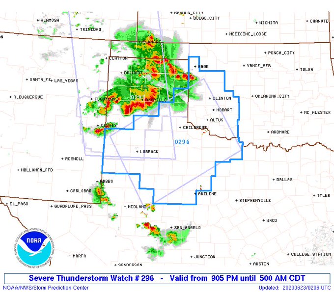
EnnisTx wrote:Looks like a third day in a row for a storm complex to move out of Oklahoma into North Texas. I'm liking this.
NAM has repeated rounds through at least Tuesday
Today, the first full day of summer was the coolest day of the month
Moderator: S2k Moderators


EnnisTx wrote:Looks like a third day in a row for a storm complex to move out of Oklahoma into North Texas. I'm liking this.


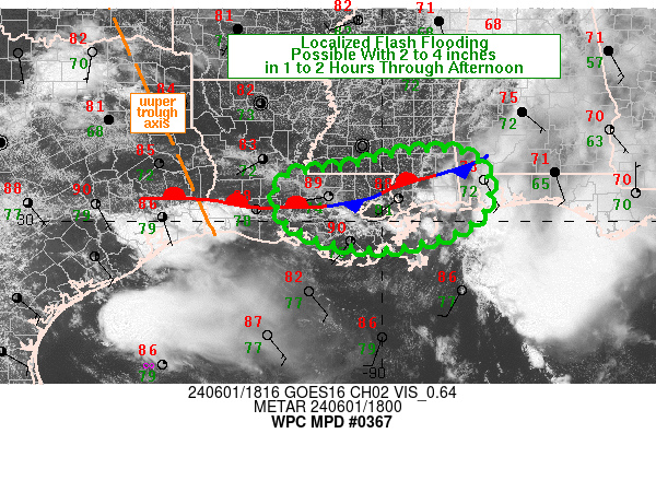
TeamPlayersBlue wrote:Another boundary slowing down right over SE Tx. Big rain numbers already popping up. Lightning is insane in my area.
Brent wrote:EnnisTx wrote:Looks like a third day in a row for a storm complex to move out of Oklahoma into North Texas. I'm liking this.
NAM has repeated rounds through at least Tuesday
Today, the first full day of summer was the coolest day of the month


bubba hotep wrote:DFW with a bit of a jackpot with about 2.5" of rain from this batch of storms putting the airport station at 5.3" for the month of June. That puts DFW 2.3" above normal for June and 11" above for the year! That should keep the lakes in good shape as we head into July and August. Also, did anyone notice the 00z Euro and the 22" between Austin and San Antonio?!
Code: Select all
Date   Tahiti (hPa)   Darwin (hPa)   Daily Contribution   30 day Av. SOI   90 day Av. SOI
23 Jun 2020   1015.31   1012.75   8.93   -7.82   -3.04
22 Jun 2020   1013.54   1011.90   2.46   -8.59   -3.20
21 Jun 2020   1011.56   1012.35   -14.62   -8.82   -3.34
20 Jun 2020   1010.11   1013.65   -33.95   -8.16   -3.31
19 Jun 2020   1010.73   1014.00   -32.05   -6.66   -3.01
18 Jun 2020   1011.31   1014.40   -30.79   -5.81   -2.73
17 Jun 2020   1011.70   1013.60   -22.42   -5.07   -2.48
16 Jun 2020   1011.95   1012.35   -11.88   -4.32   -2.40
15 Jun 2020   1011.00   1012.90   -22.42   -3.54   -2.50
14 Jun 2020   1012.84   1012.75   -8.44   -2.37   -2.42
13 Jun 2020   1013.92   1011.40   8.65   -2.12   -2.36
12 Jun 2020   1014.20   1011.10   12.72   -2.11   -2.41
11 Jun 2020   1013.53   1012.10   0.98   -2.03   -2.55
10 Jun 2020   1014.50   1013.70   -3.45   -1.94   -2.57
9 Jun 2020   1015.28   1012.95   7.31   -1.77   -2.50
8 Jun 2020   1014.40   1011.35   12.37   -1.93   -2.57
7 Jun 2020   1011.14   1011.80   -13.71   -1.99   -2.80
6 Jun 2020   1009.02   1013.20   -38.45   -1.36   -2.68
5 Jun 2020   1009.05   1014.40   -46.68   -0.45   -2.27
4 Jun 2020   1011.69   1015.15   -33.39   0.77   -1.81
3 Jun 2020   1013.83   1014.90   -16.59   1.82   -1.45
2 Jun 2020   1015.15   1014.15   -2.04   2.54   -1.19
1 Jun 2020   1017.01   1014.35   9.63   2.85   -1.07


Return to “USA & Caribbean Weather”
Users browsing this forum: Yukon Cornelius and 44 guests