SE TX/SW LA weather: Much cooler and WET after Tuesday

U.S. & Caribbean Weather Discussions and Severe Weather Events

Moderator: S2k Moderators

Forum rules

The posts in this forum are NOT official forecast and should not be used as such. They are just the opinion of the poster and may or may not be backed by sound meteorological data. They are NOT endorsed by any professional institution or STORM2K.

Help Support Storm2K
Message
Author
User avatar
jasons2k
Storm2k Executive
Storm2k Executive
Posts: 8245
Age: 51
Joined: Wed Jul 06, 2005 12:32 pm
Location: The Woodlands, TX

#3961 Postby jasons2k » Sat Oct 03, 2009 9:19 pm

Image
Shot at 2009-10-03
0 likes   

jeff
Professional-Met
Professional-Met
Posts: 831
Joined: Sun Sep 12, 2004 6:14 pm
Location: Houston, TX
Contact:

Re:

#3962 Postby jeff » Sat Oct 03, 2009 9:25 pm

southerngale wrote:Jeff, is that primarily for the Houston area or do we face the same flash flood threat over here? I've been sick for days and completely out of it. I had no idea that it might even rain until today. Image


BPT area faces the same threat as well especially considering the ongoing development/training over Galveston Bay/Chambers County that may work its way inland over that region.
0 likes   

User avatar
southerngale
Retired Staff
Retired Staff
Posts: 27418
Joined: Thu Oct 10, 2002 1:27 am
Location: Southeast Texas (Beaumont area)

#3963 Postby southerngale » Sat Oct 03, 2009 9:29 pm

Thanks, Jeff. I'll keep an eye out. We appreciate your input.

I had a very heavy shower this afternoon, but it didn't last all that long. Mostly just light to moderate stuff off and on, mostly on this evening. So far, just some welcomed rain.
0 likes   
Please support Storm2k by making a donation today. It is greatly appreciated! Click here: Image

Image my Cowboys Image my RocketsImage my Astros

User avatar
srainhoutx
S2K Supporter
S2K Supporter
Posts: 6919
Age: 67
Joined: Sun Jan 14, 2007 11:34 am
Location: Haywood County, NC
Contact:

Re: SE TX/SW LA weather: Heavy Rainfall Possible

#3964 Postby srainhoutx » Sat Oct 03, 2009 9:46 pm

SATELLITE PRECIPITATION ESTIMATES..DATE/TIME 10/04/09 0105Z
SATELLITE ANALYSIS BRANCH/NESDIS---NPPU---TEL.301-763-8678
LATEST DATA USED: GOES-12: 0045Z BELGE
.
LOCATION...TEXAS...
.
ATTN WFOS...HGX...CRP...EWX...
ATTN RFCS...WGRFC...
.
EVENT...VERY COLD TOP CONVECTION CONTINUING OVER SE TX.
.
SATELLITE ANALYSIS AND TRENDS...IR IMAGERY INDICATING VERY COLD CLOUD
TOPS INVOF REFUGIO/GOLIAD/VICTORIA COUNTIES IN SE TX ATTM WHERE TEMPS
ARE APPROACHING -77C. NUMEROUS CELL MERGERS HAVE OCCURRED IN THIS REGION
OVER THE PAST HOUR OR SO RESULTING IN THE COLD CLOUD TOPS AND SUBSEQUENT
HEAVY RAINFALL ACROSS THIS REGION. AUTOMATED SATELLITE ESTIMATES ARE
SHOWING A MAX OF ABOUT 3.3" IN THE PAST 3 HRS NEAR THE GOLIAD AND BEE
COUNTY BORDER WHICH IS CLOSE TO THE 3-HR FFG VALUES IN THIS REGION. GOOD
NEWS IS THAT THE MAIN CORE OF HVY PRECIP DOES SEEM TO BE MOVING EAST OUT
OF THIS REGION BUT SOME BACKBUILDING HAS BEEN OCCURRING OVER THE REGION
SO CAN'T RULE OUT THE THREAT FOR SOME MORE MOD TO POSSIBLY HVY RAINFALL
FOR THE NEXT 1-2 HRS.
.
PLEASE SEE WEB ADDRESS BELOW IN ABOUT 10 MINUTES FOR AUTOMATED SATELLITE
ESTIMATE GRAPHIC.
0 likes   
Carla/Alicia/Jerry(In The Eye)/Michelle/Charley/Ivan/Dennis/Katrina/Rita/Wilma/Ike/Harvey

Member: National Weather Association
Wx Infinity Forums
http://wxinfinity.com/index.php

Facebook.com/WeatherInfinity
Twitter @WeatherInfinity

User avatar
TexasSam
Category 2
Category 2
Posts: 573
Age: 66
Joined: Thu Aug 28, 2003 12:16 am
Location: Port Arthur, Texas

Re: SE TX/SW LA weather: Heavy Rainfall Possible

#3965 Postby TexasSam » Sat Oct 03, 2009 10:18 pm

BULLETIN - IMMEDIATE BROADCAST REQUESTED
SPECIAL MARINE WARNING
NATIONAL WEATHER SERVICE HOUSTON/GALVESTON TX
1001 PM CDT SAT OCT 3 2009

THE NATIONAL WEATHER SERVICE IN LEAGUE CITY HAS ISSUED A

* SPECIAL MARINE WARNING FOR...
COASTAL WATERS FROM HIGH ISLAND TO FREEPORT TX OUT 20 NM...

* UNTIL 1100 PM CDT

* AT 1000 PM CDT...NATIONAL WEATHER SERVICE DOPPLER RADAR INDICATED A
THUNDERSTORM...POSSIBLY PRODUCING A WATERSPOUT 10 NM EAST OF
GALVESTON...MOVING NORTHEAST AT 10 KNOTS.

PRECAUTIONARY/PREPAREDNESS ACTIONS...

AS THUNDERSTORMS MOVE OVER THE WATER...BOATERS CAN EXPECT GUSTY WIND
AND HIGH WAVES. MOVE TO SAFE HARBOR OR STAY CLOSE TO SHORE UNTIL THE
STORM PASSES.

THUNDERSTORMS CAN PRODUCE SUDDEN WATERSPOUTS. WATERSPOUTS CAN EASILY
OVERTURN BOATS AND CREATE LOCALLY HAZARDOUS SEAS. SEEK SAFE HARBOR
IMMEDIATELY.
0 likes   

User avatar
JenBayles
Category 5
Category 5
Posts: 3461
Age: 62
Joined: Tue Aug 26, 2003 3:27 pm
Location: Houston, TX
Contact:

#3966 Postby JenBayles » Sat Oct 03, 2009 10:21 pm

Looking at radar trends the past couple hours, I think I can sleep tonight - a few hours anyway. I see more rain developing around San Antonio but hopefully won't have to worry about it until morning.

Yeah, one flood is all it took to completely wreck our enjoyment of nighttime thunderstorms. I'm not as whacked out as my husband though. If we had any hope of selling this house we'd be gone yesterday. Ah well... hope springs eternal. :-)
0 likes   

User avatar
southerngale
Retired Staff
Retired Staff
Posts: 27418
Joined: Thu Oct 10, 2002 1:27 am
Location: Southeast Texas (Beaumont area)

#3967 Postby southerngale » Sat Oct 03, 2009 10:47 pm

The Houston area seems to mysteriously dissipate everything as it approaches Houston and before it makes it over here. If we get any more heavy rain, I think it'll be from what is lifting north, not from what is moving east. What did y'all do to the air over there? :P

http://radar.weather.gov/radar.php?product=N0R&rid=hgx&loop=yes

Good luck, Jen! Sleep well.
0 likes   
Please support Storm2k by making a donation today. It is greatly appreciated! Click here: Image

Image my Cowboys Image my RocketsImage my Astros

User avatar
Diva
S2K Supporter
S2K Supporter
Posts: 205
Joined: Fri Jun 16, 2006 11:46 am
Location: Orange, TX

#3968 Postby Diva » Sat Oct 03, 2009 10:56 pm

Well, oddly enough we only had light rain today at Galena Park during the Band Marching Competition. On and off drizzle and then the heavier rain started when we left around 6:30, after the awards presentation. Drove home with moderate rain the whole way. So, only on and off rain and our band (Little Cypress-Mauriceville Battlin' Bear Band) placed 1st and brought home the BIG trophy! Not a bad day!!
Here's hoping no flooding rains are coming to us or our neighbors in the next 24 hours.
0 likes   

User avatar
vbhoutex
Storm2k Executive
Storm2k Executive
Posts: 29113
Age: 73
Joined: Wed Oct 09, 2002 11:31 pm
Location: Cypress, TX
Contact:

Re: SE TX/SW LA weather: Heavy Rainfall Possible

#3969 Postby vbhoutex » Sat Oct 03, 2009 11:09 pm

vbhoutex wrote:
vbhoutex wrote:That storm was presenting a pretty decent hook echo for a while to the NW of Ganado. Looks less pronounced mow, but people in the path need to be very alert since these can pop right back(id it was a tornado).

Following up on this. I haven't heard nay reports on this, but there was a very pronounced hook echo as it went through Ganado. Hopefully there was no touchdown. No evidence of a hook at this time.

News this evening says law enforcement reported tornado on the ground and some trees and power poles down. Fortunately it hit a very rural area near Ganado apparently.

Meanwhile radar is showing some moderate rain moving in from the West. It has definitely picked up again here in Spring Branch but nothing to write home about yet fortunately. So far just some good soaking rains.
0 likes   

User avatar
Ptarmigan
Category 5
Category 5
Posts: 5313
Joined: Wed Aug 16, 2006 9:06 pm

Re: SE TX/SW LA weather: Heavy Rainfall Possible

#3970 Postby Ptarmigan » Sun Oct 04, 2009 12:27 am

Out of Corpus Christi radar, it estimates 4 inches of rain per hour. Don't know if there hail or not.

http://radar.weather.gov/radar.php?rid= ... 11&loop=no

So far about 6 inches of rain has fallen.
0 likes   

User avatar
srainhoutx
S2K Supporter
S2K Supporter
Posts: 6919
Age: 67
Joined: Sun Jan 14, 2007 11:34 am
Location: Haywood County, NC
Contact:

Re: SE TX/SW LA weather: Heavy Rainfall Possible

#3971 Postby srainhoutx » Sun Oct 04, 2009 1:01 am

SPC thoughts about an hour ago but worth posting...snipet...

...S-CENTRAL/SE TX...SRN LA...
CONSIDERABLE UNCERTAINTY EXISTS REGARDING EXTENT OF NWD MOTION OF
WARM FRONT...GIVEN LIKELIHOOD OF EXTENSIVE CONVECTION AND PRECIP TO
ITS N FOR MUCH OF PERIOD. WEAK TROUGH ALOFT NOW OVER MID/UPPER TX
COAST MAY AID IN MAINTAINING FAVORABLE ENVIRONMENT FOR CONVECTION
OFFSHORE UPPER TX COAST AND LA EARLY IN PERIOD AND DELAY NWD FRONTAL
RETREAT OVER THERE. LAPSE RATES ALOFT GENERALLY SHOULD REMAIN
MRGLLY UNSTABLE...AS MESOSCALE/WEAK DPVA REGIONALLY COUNTERACTS
BROADER STABILIZING EFFECTS ALOFT FROM SYNOPTIC HEIGHT RISES AND
PLUME OF TROPICAL MID-UPPER AIR ADVECTING FROM NWRN MEX.
LOW-LEVEL THERMODYNAMICS WILL REMAIN FAVORABLE WITHIN AND S OF SFC
FRONTAL ZONE...WITH DEW POINTS COMMONLY IN 70S AND SFC HEATING OVER
LAND AREAS REMOVED FROM CLOUD COVER. MLCAPE 2000-3000 J/KG MAY
DEVELOP ALONG AND JUST S OF EFFECTIVE FRONT. PRIND BOUNDARY WILL
NOT RETREAT NWD AS FAST AS FAVORABLE MID-UPPER WINDS OVER REGION.
THIS EFFECT SHOULD MAKE SUPERCELL POTENTIAL
SHORT-LIVED...HEAVY-PRECIP IN MODE...AND TORNADO THREAT VERY MRGL
AND CONDITIONAL ON BOUNDARY INTERACTIONS. ISOLATED STG/DAMAGING
GUSTS ALSO ARE POSSIBLE FROM MOST INTENSE CELLS.


http://www.spc.noaa.gov/products/outlook/day1otlk.html
0 likes   
Carla/Alicia/Jerry(In The Eye)/Michelle/Charley/Ivan/Dennis/Katrina/Rita/Wilma/Ike/Harvey

Member: National Weather Association
Wx Infinity Forums
http://wxinfinity.com/index.php

Facebook.com/WeatherInfinity
Twitter @WeatherInfinity

User avatar
jasons2k
Storm2k Executive
Storm2k Executive
Posts: 8245
Age: 51
Joined: Wed Jul 06, 2005 12:32 pm
Location: The Woodlands, TX

#3972 Postby jasons2k » Sun Oct 04, 2009 8:33 am

Looks like the heaviest rains overnight were either to the west, or in some bands to the east. The radar this AM looks almost the exact same as it did when I went to bed. I wonder why everything melts away as soon as it approaches the Houston area. Reminds me of the last event.....just weird.
0 likes   

User avatar
srainhoutx
S2K Supporter
S2K Supporter
Posts: 6919
Age: 67
Joined: Sun Jan 14, 2007 11:34 am
Location: Haywood County, NC
Contact:

Re: SE TX/SW LA weather: Heavy Rainfall Possible

#3973 Postby srainhoutx » Sun Oct 04, 2009 9:07 am

And to think we will have this El Nino like pattern all winter. ~Sigh~
0 likes   
Carla/Alicia/Jerry(In The Eye)/Michelle/Charley/Ivan/Dennis/Katrina/Rita/Wilma/Ike/Harvey

Member: National Weather Association
Wx Infinity Forums
http://wxinfinity.com/index.php

Facebook.com/WeatherInfinity
Twitter @WeatherInfinity

User avatar
srainhoutx
S2K Supporter
S2K Supporter
Posts: 6919
Age: 67
Joined: Sun Jan 14, 2007 11:34 am
Location: Haywood County, NC
Contact:

Re: SE TX/SW LA weather: Heavy Rainfall Possible

#3974 Postby srainhoutx » Sun Oct 04, 2009 9:34 am

Keep an eye on Matagorda and Brazoria Counties. Almost appears a Meso Low is developing which would bring very heavy rainfall to those areas.
0 likes   
Carla/Alicia/Jerry(In The Eye)/Michelle/Charley/Ivan/Dennis/Katrina/Rita/Wilma/Ike/Harvey

Member: National Weather Association
Wx Infinity Forums
http://wxinfinity.com/index.php

Facebook.com/WeatherInfinity
Twitter @WeatherInfinity

User avatar
srainhoutx
S2K Supporter
S2K Supporter
Posts: 6919
Age: 67
Joined: Sun Jan 14, 2007 11:34 am
Location: Haywood County, NC
Contact:

Re: SE TX/SW LA weather: Heavy Rainfall Possible

#3975 Postby srainhoutx » Sun Oct 04, 2009 9:37 am

HGX Update...

AREA FORECAST DISCUSSION
NATIONAL WEATHER SERVICE HOUSTON/GALVESTON TX
932 AM CDT SUN OCT 4 2009

.DISCUSSION...
STRONG CONVECTION BECOMING CLUSTERED AND MORE ORGANIZED JUST WEST
OF EDNA AND EAGLE LAKE. AMPLE LOW LEVEL SHEAR HAS RESULTED IN
SUPERCELL DEVELOPMENT EARLIER WEST OF CWFA. UPPER LEVEL ANALYZED
DATA INDICATE 850 MB TROUGH EAST-WEST NEAR AND JUST SOUTH OF THE
RED RIVER WITH STRONG MOISTURE CONVERGENCE TOWARD TROUGH.
SURFACE FEATURES MORE COMPLICATED. SURFACE FRONTAL BOUNDARY
EXTENDING FROM BETWEEN ACT AND CRS TO JUST SOUTH OF GGG. ANOTHER
BOUNDARY (ALBEIT WEAKER) OR WEAK SURFACE TROUGH EXTENDS FROM
BETWEEN SAT AND BEA TO NEAR HALLETTSVILLE. PW VALUES REMAIN QUITE
HIGH OVER OUR REGION RANGING FROM 2.2 TO 2.5 INCHES. WE INCREASED
POPS SW ZONES FOR REST OF THIS MORNING ANTICIPATING EASTWARD
PROPAGATION OF LARGE AREA OF CONVECTION AS AFOREMENTIONED. WE
INCLUDED LOCALLY HEAVY RAINFALL FROM STRONGER STORMS AREA WIDE
THIS MORNING AND OVER NORTHERN PORTIONS THIS AFTERNOON. 37/45
0 likes   
Carla/Alicia/Jerry(In The Eye)/Michelle/Charley/Ivan/Dennis/Katrina/Rita/Wilma/Ike/Harvey

Member: National Weather Association
Wx Infinity Forums
http://wxinfinity.com/index.php

Facebook.com/WeatherInfinity
Twitter @WeatherInfinity

User avatar
srainhoutx
S2K Supporter
S2K Supporter
Posts: 6919
Age: 67
Joined: Sun Jan 14, 2007 11:34 am
Location: Haywood County, NC
Contact:

Re: SE TX/SW LA weather: Heavy Rainfall Possible

#3976 Postby srainhoutx » Sun Oct 04, 2009 9:41 am

Jeff just sent an Update...

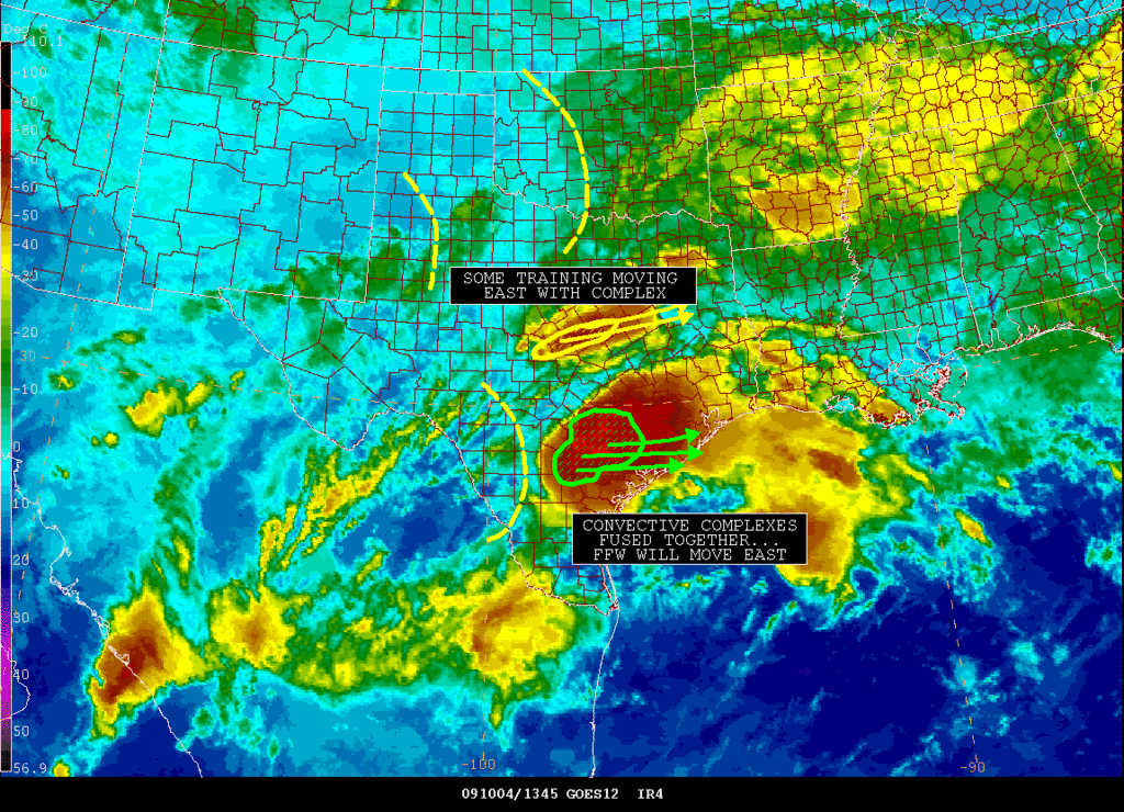
Excessive rainfall resulting in flash flooding across C and SC TX this morning.

Overnight impressive rainfall totals of 5-8 inches were recorded over the Comal, Guadalupe, Lavaca, Bee, and Gonzales County area. This includes CoCoRaHS reports of: 8.01" near New Berlin with 2.21" in 51 minutes, 6.32 inches at San Marcos, 7.16 inches in Comal County, and 5.80 inches in 2 hours in Comal County.

Warm front is finally progressing northward over SE TX while approaching strong short wave has induced meso low pressure N of VCT with a developing squall line extending south of this feature. Tropical tap from Olaf remains in place and AM CRP sounding showed 2.45 inches of PW so the air mass is just about as moist as it gets. Widespread 1-2" has fallen so far W of I-45 with 3-5 inches of Wharton and Jackson Counties and even higher totals just west of that.

Concern today will be the advance of the next short wave and then the possible southward movement of the warm frontal boundary tonight keeping he heavy rainfall focus over the area. Expect to see the development to our west push through the region this afternoon with a break in the rains following. Next impulse will swing into SW TX this afternoon and possibly fire off more storms. Mid level heights will begin to build as noted on the CRP sounding, but if we get any breaks behind the departing short wave this may be enough to overcome the developing unfavorable capping. Other issue is what to do with the low level boundary. Current incoming convection may send the boundary back south into the coastal waters which places us back into the same situation as yesterday. Hard to call such a highly meso-scale setup...so will opt to see how things place out convectively this afternoon and then pin point the threat for excessive rainfall for tonight into Monday. While models favor our northern counties...I am not so sure the threat will be that far north.

As mentioned before this air mass is completely saturated from the surface through about 300mb, PWS of 2.25-2.45 inches, slow moving/training convection, and low level boundary all point to a flash flood threat. Rainfall totals overnight have proven the ability of this air mass to produce some quick high rainfall rates. Will continue with an additional 1-3 inches widespread with isolated 4-6 inches possible. Would not be surprised to see a few 8-10 inch totals by Monday morning especially over our western and SW counties where storms have been tending to anchor.
0 likes   
Carla/Alicia/Jerry(In The Eye)/Michelle/Charley/Ivan/Dennis/Katrina/Rita/Wilma/Ike/Harvey

Member: National Weather Association
Wx Infinity Forums
http://wxinfinity.com/index.php

Facebook.com/WeatherInfinity
Twitter @WeatherInfinity

User avatar
JenBayles
Category 5
Category 5
Posts: 3461
Age: 62
Joined: Tue Aug 26, 2003 3:27 pm
Location: Houston, TX
Contact:

#3977 Postby JenBayles » Sun Oct 04, 2009 9:59 am

ACK. "Slow moving" and "training" are bad words. Hopefully the Bear Creek Dome will hold today as it did last night. It is weird how the rain hits Harris County and simply disappears. Not that I'm complaining! :D
0 likes   

User avatar
srainhoutx
S2K Supporter
S2K Supporter
Posts: 6919
Age: 67
Joined: Sun Jan 14, 2007 11:34 am
Location: Haywood County, NC
Contact:

Re: SE TX/SW LA weather: Heavy Rainfall Possible

#3978 Postby srainhoutx » Sun Oct 04, 2009 10:01 am

srainhoutx wrote:Keep an eye on Matagorda and Brazoria Counties. Almost appears a Meso Low is developing which would bring very heavy rainfall to those areas.


Heads Up for Ft Bent, Southern Harris, and Galveston Counties...

SATELLITE PRECIPITATION ESTIMATES..DATE/TIME 10/04/09 1422Z
SATELLITE ANALYSIS BRANCH/NESDIS---NPPU---TEL.301-763-8678
LATEST DATA USED: GOES-12 1415Z KUSSELSON
.
LOCATION...SOUTHEAST TEXAS...
.
ATTN WFOS...HGX...CRP...EWX...
ATTN RFCS...WGRFC...
.
EVENT...CONVECTIVE MERGER OR FUSING OF TWO CONVECTIVE COMPLEXES...
.
SATELLITE ANALYSIS AND TRENDS...WOULD CONSIDER THE NOW ONE CONVECTIVE
COMPLEX OVER SOUTHEAST TX A FUSING OF TWO SMALL COMPLEXES OVER THE PAST
2HRS WITH SOME OFTHE HIGHEST RAIN RATES OF 2+"/HR OCCURRING KARNES TO
BEE COUNTY WITH BEST MULTIPLE BURSTS GONZALES TO DEWITT COUNTY. THINK
WHOLE AREA WILL MOVE STRAIGHT EAST TO VICTORIA TO JACKSON TO FORT BEND
AND MAYBE AT LEAST THE SOUTHERN HOUSTON SUBURBS FOR LATE MORNING/MIDDAY.

EXCESSIVE HIGH PWATS DRIFTING SLOWLY NORTH FROM KCRP AREA FROM 12Z
ANOTHER REASON COMPLEX WILL SHIFT EAST...MAYBE A LITTLE NORTH OF EAST.
AND ALSO BEST UPPER LEVEL DIVERGENCE CENTERED CLOSER TO THE HOUSTON AREA.

OTHER SHORT WAVES WEAK OUT TO THE WEST....SO WILL HAVE TO SEE IF MORE
CONVECTION CAN DEVELOP LATER TODAY AND TAKE ADVANTAGE OF EXTREMELY HIGH
MOISTURE THAT WILL REMAIN.

Image
0 likes   
Carla/Alicia/Jerry(In The Eye)/Michelle/Charley/Ivan/Dennis/Katrina/Rita/Wilma/Ike/Harvey

Member: National Weather Association
Wx Infinity Forums
http://wxinfinity.com/index.php

Facebook.com/WeatherInfinity
Twitter @WeatherInfinity

User avatar
JenBayles
Category 5
Category 5
Posts: 3461
Age: 62
Joined: Tue Aug 26, 2003 3:27 pm
Location: Houston, TX
Contact:

#3979 Postby JenBayles » Sun Oct 04, 2009 10:27 am

Lord, what a mess. At least it's Sunday so hopefully most folks in the worst areas are off the roads.
0 likes   

User avatar
srainhoutx
S2K Supporter
S2K Supporter
Posts: 6919
Age: 67
Joined: Sun Jan 14, 2007 11:34 am
Location: Haywood County, NC
Contact:

Re: SE TX/SW LA weather: Heavy Rainfall Possible

#3980 Postby srainhoutx » Sun Oct 04, 2009 10:30 am

Yeah Jen, it is a mess...

SPECIAL WEATHER STATEMENT
NATIONAL WEATHER SERVICE HOUSTON/GALVESTON TX
1023 AM CDT SUN OCT 4 2009

TXZ210-226-235-236-041645-
COLORADO-JACKSON-MATAGORDA-WHARTON-
1023 AM CDT SUN OCT 4 2009

...SPECIAL WEATHER STATEMENT...

AT 1018 AM CDT...NATIONAL WEATHER SERVICE DOPPLER RADAR INDICATED
STRONG THUNDERSTORMS ALONG A LINE EXTENDING FROM 24 MILES SOUTHWEST
OF EAGLE LAKE TO 17 MILES WEST OF EL CAMPO TO 11 MILES SOUTH OF
EDNA...MOVING EAST AT 15 TO 20 MPH.

EXPECT WINDS GREATER THAN 30 MPH WITH HIGHER GUSTS ESPECIALLY ALONG
A CORRIDOR FROM MORALES TO EL CAMPO TO WHARTON AND NADA...HEAVY
DOWNPOURS OF AROUND 2 INCHES PER HOUR CAN BE EXPECTED AS WELL WITH
THESE STORMS.

LOCATIONS IN THE PATH OF THESE STORMS INCLUDE...VANDERBILT...
SHERIDAN...ROCK ISLAND...PIERCE...NADA...MORALES...MIDFIELD...
LOUISE...LAKE TEXANA DAM...HUNGERFORD...GARWOOD...EGYPT...DANEVANG...
CORDELE...BLESSING...WHARTON...MARKHAM...LA WARD...GANADO...EL
CAMPO...EDNA AND EAGLE LAKE.
0 likes   
Carla/Alicia/Jerry(In The Eye)/Michelle/Charley/Ivan/Dennis/Katrina/Rita/Wilma/Ike/Harvey

Member: National Weather Association
Wx Infinity Forums
http://wxinfinity.com/index.php

Facebook.com/WeatherInfinity
Twitter @WeatherInfinity


Return to “USA & Caribbean Weather”

Who is online

Users browsing this forum: No registered users and 18 guests