

Texas Summer - 2014
Moderator: S2k Moderators
Forum rules

The posts in this forum are NOT official forecast and should not be used as such. They are just the opinion of the poster and may or may not be backed by sound meteorological data. They are NOT endorsed by any professional institution or STORM2K.
Re: Texas Summer - 2014
Well it may not be all that bad. EWX thinks there may be a couple of rounds of Storm complexes that will form up in northwest Texas and propagate south/southeastward into the Hill Country and the Metro area. If that holds true, we could see up to an inch with a few isolated spots a little more. These complexes will be moving fairly quickly so it's unlikely there will be a flooding concern but I cringe every time I see the word hail mentioned.
0 likes
Resident Rain Miser
I am a weather hobbyist living 3.5 miles south of Downtown Austin and in no way or fashion should anything I say concerning forecasts be taken seriously. Please check your local NWS for accurate weather forecasting and conditions.
I am a weather hobbyist living 3.5 miles south of Downtown Austin and in no way or fashion should anything I say concerning forecasts be taken seriously. Please check your local NWS for accurate weather forecasting and conditions.


Re: Texas Summer - 2014
June 6 12Z Euro, for entertainment purposes. Nice donut hole near the metroplex. 


0 likes
The above post and any post by dhweather is NOT an official forecast and should not be used as such. It is just the opinion of the poster and may or may not be backed by sound meteorological data. It is NOT endorsed by any professional institution including storm2k.org. For official information, please refer to NWS products.
-
TheProfessor

- Professional-Met

- Posts: 3506
- Age: 29
- Joined: Tue Dec 03, 2013 10:56 am
- Location: Wichita, Kansas


Yet another EPAC system setting up. 94E is up, good chance it may become Cristina and a run at hurricane status. This one will track west like Amanda.

0 likes
The above post and any post by Ntxw is NOT an official forecast and should not be used as such. It is just the opinion of the poster and may or may not be backed by sound meteorological data. It is NOT endorsed by any professional institution including Storm2k. For official information, please refer to NWS products.
Help support Storm2K!
HI RES and short range guidance shows a complex of storms making it's way into areas along and north of I-20 this evening lingering through tomorrow morning. Lets see if that pans out! Could be some good rain makers moving along outflow boundaries from west to east.
Next 3 days worth per WPC

Next 3 days worth per WPC
0 likes
The above post and any post by Ntxw is NOT an official forecast and should not be used as such. It is just the opinion of the poster and may or may not be backed by sound meteorological data. It is NOT endorsed by any professional institution including Storm2k. For official information, please refer to NWS products.
Help support Storm2K!
Help support Storm2K!
-
TheProfessor
- Professional-Met
- Posts: 3506
- Age: 29
- Joined: Tue Dec 03, 2013 10:56 am
- Location: Wichita, Kansas
0 likes
An alumnus of The Ohio State University.
Your local National Weather Service office is your best source for weather information.
Your local National Weather Service office is your best source for weather information.
Re:
TheProfessor wrote::uarrow: I saw a graphic on FWD that had a high pressure is blocking storms south of I-20, so is it possible that the outflow boundary could stall and train a cross the northern half of the metro until energy is gone leading to more rain than forecasted?
We'll have to wait and see how far south these storms initiate. The ridge is to the south and weakening splitting one in the gulf and the other over NW MX. The GFS is turning around from nada to measure-able rainfall for tonight into tomorrow so it's possible could see more than previously thought. Another complex will probably set up again tomorrow afternoon.
Something overlooked is the "cooler" air after the rain. Low to mid 60s will be quite refreshing for Tuesday morning, below normal

0 likes
The above post and any post by Ntxw is NOT an official forecast and should not be used as such. It is just the opinion of the poster and may or may not be backed by sound meteorological data. It is NOT endorsed by any professional institution including Storm2k. For official information, please refer to NWS products.
Help support Storm2K!
Help support Storm2K!
Re: Texas Summer - 2014
That nice large complex is moving pretty quickly to the southeast. A familiar set up for this time of year. The question is will it hold together till sunrise? Will be watching closely over the next 6 hours. I'm not expecting it to make it this far tonight but should be an indication of what may happen tomorrow night.
0 likes
Resident Rain Miser
I am a weather hobbyist living 3.5 miles south of Downtown Austin and in no way or fashion should anything I say concerning forecasts be taken seriously. Please check your local NWS for accurate weather forecasting and conditions.
I am a weather hobbyist living 3.5 miles south of Downtown Austin and in no way or fashion should anything I say concerning forecasts be taken seriously. Please check your local NWS for accurate weather forecasting and conditions.
-
weatherdude1108
- Category 5

- Posts: 4228
- Joined: Tue Dec 13, 2011 1:04 pm
- Location: Northwest Austin/Cedar Park, TX
-
South Texas Storms

- Professional-Met
- Posts: 4256
- Joined: Thu Jun 24, 2010 12:28 am
- Location: Houston, TX
Re: Texas Summer - 2014
I'm hopeful that at least one MCS will make it as far south as IH 10 in the next 72 hours. It looks like north TX will get some nice rainfall in the next few days. I hope south central TX will get some too!
0 likes
-
weatherdude1108
- Category 5
- Posts: 4228
- Joined: Tue Dec 13, 2011 1:04 pm
- Location: Northwest Austin/Cedar Park, TX
-
aggiecutter
- Category 5
- Posts: 1755
- Joined: Thu Oct 14, 2004 9:22 pm
- Location: Texarkana

-
aggiecutter
- Category 5
- Posts: 1755
- Joined: Thu Oct 14, 2004 9:22 pm
- Location: Texarkana
Re: Texas Summer - 2014
1.5" of rain in just 30 minutes and golf ball sized hail reported in Texarkana. There were 4 separate Tornado warnings issued for the Texarkana area over the past hour, and an unconfirmed touchdown with damage in the NE part of town.
0 likes
-
aggiecutter
- Category 5
- Posts: 1755
- Joined: Thu Oct 14, 2004 9:22 pm
- Location: Texarkana
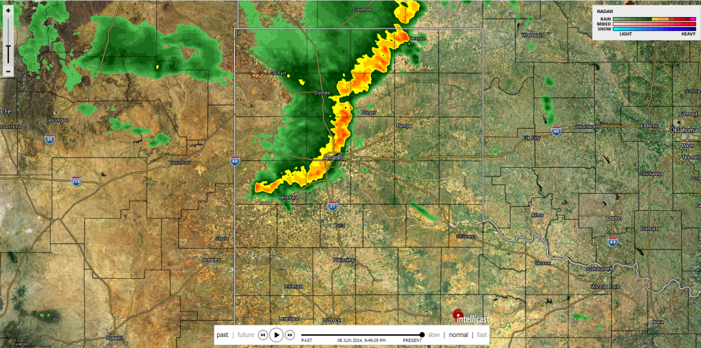
Re: Texas Summer - 2014
Intense squall line traversing the panhandle this evening. Wonder what it means downstream for parts of northern Texas:

0 likes
-
horselattitudesfarm

- Category 1

- Posts: 315
- Joined: Thu Jul 16, 2009 5:55 pm
- Location: Asheville, NC (formerly from Dallas, TX)
Re: Texas Summer - 2014
Tell me anyone, is this a radar issue or did a band of precip. really set up along I-35 3 times in 2 months on these weekly totals:
First time: May 4th-May 11th

Second time: May 14th-May 21rst

3rd. time: June 1rst- June 8th

First time: May 4th-May 11th

Second time: May 14th-May 21rst

3rd. time: June 1rst- June 8th

0 likes
65F and raining...and its almost mid June by the end of the week. Dreaming of 1903! Certainly feels like it outside  . Which surprisingly that year holds quite a few of DFW's min records the next couple of months.
Record low for DFW today is 59F, oh how close we are by 6 degrees. Point is how refreshing! Could be cooler tomorrow morning.
Record low for DFW today is 59F, oh how close we are by 6 degrees. Point is how refreshing! Could be cooler tomorrow morning.
Last edited by Ntxw on Mon Jun 09, 2014 8:40 am, edited 2 times in total.
0 likes
The above post and any post by Ntxw is NOT an official forecast and should not be used as such. It is just the opinion of the poster and may or may not be backed by sound meteorological data. It is NOT endorsed by any professional institution including Storm2k. For official information, please refer to NWS products.
Help support Storm2K!
Help support Storm2K!
Return to “USA & Caribbean Weather”
Who is online
Users browsing this forum: Yukon Cornelius and 44 guests