2020 Global Model Runs Discussion (Out thru day 16)
Moderator: S2k Moderators
Forum rules

The posts in this forum are NOT official forecasts and should not be used as such. They are just the opinion of the poster and may or may not be backed by sound meteorological data. They are NOT endorsed by any professional institution or STORM2K. For official information, please refer to products from the National Hurricane Center and National Weather Service.
-
gatorcane

- S2K Supporter

- Posts: 23708
- Age: 48
- Joined: Sun Mar 13, 2005 3:54 pm
- Location: Boca Raton, FL
Re: 2020 Global Model Runs Discussion (Out thru day 16)
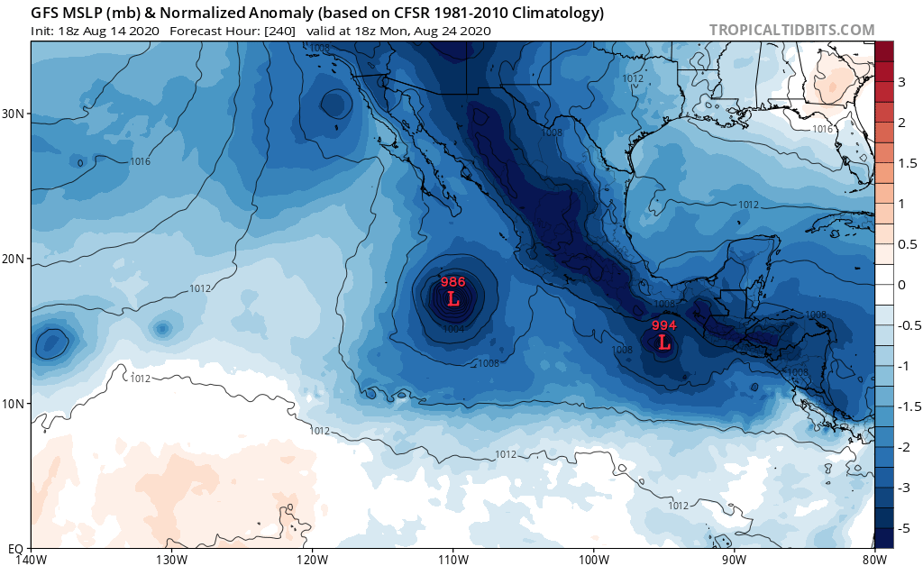
Zilch on the GFS rest of month in the Atlantic. As some of said shows even more in the EPAC, at least a few more storms that spin up:
2 likes
-
stormlover2013
Re: 2020 Global Model Runs Discussion (Out thru day 16)
gatorcane wrote:Zilch on the GFS rest of month in the Atlantic. As some of said shows even more in the EPAC, at least a few more storms that spin up:
https://i.postimg.cc/kg8yG5zx/gfs-mslpa-Norm-epac-41.png
Gfs sucks
4 likes
-
BYG Jacob
Re: 2020 Global Model Runs Discussion (Out thru day 16)
gatorcane wrote:Zilch on the GFS rest of month in the Atlantic. As some of said shows even more in the EPAC, at least a few more storms that spin up:
https://i.postimg.cc/kg8yG5zx/gfs-mslpa-Norm-epac-41.png
This is blatant cherry picking. You are also ignoring the very well known flaws of the GFS
7 likes

Re: 2020 Global Model Runs Discussion (Out thru day 16)
stormlover2013 wrote:gatorcane wrote:Zilch on the GFS rest of month in the Atlantic. As some of said shows even more in the EPAC, at least a few more storms that spin up:
https://i.postimg.cc/kg8yG5zx/gfs-mslpa-Norm-epac-41.png
Gfs sucks
Neither the Euro or GFS showed any storms, or even low pressures, in their 120 hour forecast for today.
0 likes
The above post is not official and should not be used as such. It is the opinion of the poster and may or may not be backed by sound meteorological data. It is not endorsed by any professional institution or storm2k.org. For official information, please refer to the NHC and NWS products.
-
StruThiO

- Category 3

- Posts: 821
- Age: 26
- Joined: Fri Sep 15, 2017 5:51 am
- Location: Currently Portland, OR. Raised in Jax, FL.
Re: 2020 Global Model Runs Discussion (Out thru day 16)
gatorcane wrote:Zilch on the GFS rest of month in the Atlantic. As some of said shows even more in the EPAC, at least a few more storms that spin up:
https://i.postimg.cc/kg8yG5zx/gfs-mslpa-Norm-epac-41.png
https://twitter.com/MJVentrice/status/1293914771515944960
https://twitter.com/MJVentrice/status/1293914771515944960
https://twitter.com/MJVentrice/status/1293914771515944960
https://twitter.com/MJVentrice/status/1293914771515944960
https://twitter.com/MJVentrice/status/1293914771515944960
https://twitter.com/MJVentrice/status/1293914771515944960
https://twitter.com/MJVentrice/status/1293914771515944960
14 likes
-
Hurricaneman

- Category 5

- Posts: 7404
- Age: 45
- Joined: Tue Aug 31, 2004 3:24 pm
- Location: central florida
Re: 2020 Global Model Runs Discussion (Out thru day 16)
Hammy wrote:stormlover2013 wrote:gatorcane wrote:Zilch on the GFS rest of month in the Atlantic. As some of said shows even more in the EPAC, at least a few more storms that spin up:
https://i.postimg.cc/kg8yG5zx/gfs-mslpa-Norm-epac-41.png
Gfs sucks
Neither the Euro or GFS showed any storms, or even low pressures, in their 120 hour forecast for today.
The models haven’t been exactly stellar when it comes to cyclogenesis until there’s actually something there this year
8 likes

Re: 2020 Global Model Runs Discussion (Out thru day 16)
Hammy wrote:stormlover2013 wrote:gatorcane wrote:Zilch on the GFS rest of month in the Atlantic. As some of said shows even more in the EPAC, at least a few more storms that spin up:
https://i.postimg.cc/kg8yG5zx/gfs-mslpa-Norm-epac-41.png
Gfs sucks
Neither the Euro or GFS showed any storms, or even low pressures, in their 120 hour forecast for today.
The models have clearly struggled with the transition to upward motion in the Atlantic, as every factor laid out by the experts points to a very active peak. Said experts have pointed out flaws in modeling and advice caution when interpreting them to avoid cherry picking a desired outcome. To add, models often struggle to detect TC outbreaks more than 2-3 days out, which is exactly what occurred in August 2017 when the season was cancelled countless times.
Last edited by KAlexPR on Fri Aug 14, 2020 10:28 pm, edited 1 time in total.
2 likes
-
TheDreamTraveler

- Category 2

- Posts: 645
- Joined: Sun Aug 22, 2010 3:10 am
- Location: PA
Re: 2020 Global Model Runs Discussion (Out thru day 16)
How many models showed Kyle forming? Not only that we have 2 storms in the atlantic during an unfavorable time before August 15th, still breaking record territory with naming. Looking at the models and assuming no storms are going to spin up isn't wise considering things will become more favorable and it'll be the heart of the season in a few weeks.
4 likes
-
DorkyMcDorkface

- Category 5
- Posts: 1039
- Age: 28
- Joined: Mon Sep 30, 2019 1:32 pm
- Location: Mid-Atlantic
Re: 2020 Global Model Runs Discussion (Out thru day 16)
Hurricaneman wrote:Hammy wrote:stormlover2013 wrote:
Gfs sucks
Neither the Euro or GFS showed any storms, or even low pressures, in their 120 hour forecast for today.
The models haven’t been exactly stellar when it comes to cyclogenesis until there’s actually something there this year
Yeah I've noticed that this year, definitely, especially the GFS. Not sure why people are banking on it so much considering how poorly it has done this year regarding cyclogenesis. In several situations it has had to play catch-up in extreme fashion; perhaps the worst examples of this being Hanna and Douglas. Take a look at this. Just awful.

Don't have a full GIF for Douglas but this is what it had early on. Just one measly closed isobar when in reality it eventually became a cat 4 east of the Hawaiian islands.

It also took forever to finally latch on to developing Isaias, but I don't have a GIF for that unfortunately. Bottom line is that the GFS has been far from reliable this season. Honestly I would chalk it up to lack of observational aircraft data but none of the other models seem to be struggling this much. Could be something with the FV3 core? Not entirely sure, but if that's the case, I would expect NOAA to take a good long look at the upgrade in the offseason, especially if it continues to bungle cyclogensis detection like this for the remainder of the season - could be dangerous.
Last edited by DorkyMcDorkface on Fri Aug 14, 2020 6:50 pm, edited 5 times in total.
14 likes
Please note the thoughts expressed by this account are solely those of the user and are from a hobbyist perspective. For more comprehensive analysis, consult an actual professional meteorologist or meteorological agency.
Floyd 1999 | Isabel 2003 | Hanna 2008 | Irene 2011 | Sandy 2012 | Isaias 2020
-
gatorcane
- S2K Supporter
- Posts: 23708
- Age: 48
- Joined: Sun Mar 13, 2005 3:54 pm
- Location: Boca Raton, FL
Re: 2020 Global Model Runs Discussion (Out thru day 16)
BYG Jacob wrote:gatorcane wrote:Zilch on the GFS rest of month in the Atlantic. As some of said shows even more in the EPAC, at least a few more storms that spin up:
https://i.postimg.cc/kg8yG5zx/gfs-mslpa-Norm-epac-41.png
This is blatant cherry picking. You are also ignoring the very well known flaws of the GFS
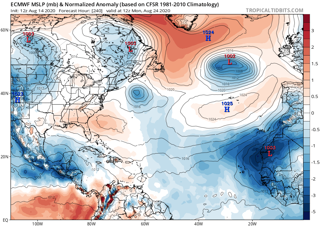
I am just posting model runs and making observations which is what this thread if for. The Euro has zilch also the next 10 days with lower pressures in the EPAC and over CA:
3 likes
-
StruThiO
- Category 3
- Posts: 821
- Age: 26
- Joined: Fri Sep 15, 2017 5:51 am
- Location: Currently Portland, OR. Raised in Jax, FL.
Re: 2020 Global Model Runs Discussion (Out thru day 16)
DorkyMcDorkface wrote:Hurricaneman wrote:Hammy wrote:
Neither the Euro or GFS showed any storms, or even low pressures, in their 120 hour forecast for today.
The models haven’t been exactly stellar when it comes to cyclogenesis until there’s actually something there this year
Yeah I've noticed that this year, definitely, especially the GFS. Not sure why people are banking on it so much considering how poorly it has done this year regarding cyclogenesis. In several situations it has had to play catch-up in extreme fashion; perhaps the worst example of this being Hanna. Take a look at this. Just awful.
https://i.ibb.co/MSCM7z7/gfs-mslp-pcpn-watl-fh6-trend-1.gif
It also took forever to finally latch on to developing Isaias, but I don't have a GIF for that unfortunately. Bottom line is that the GFS has been far from reliable this season. Honestly I would chalk it up to lack of observational aircraft data but none of the other models seem to be struggling this much. Could be something with the FV3 core? Not entirely sure, but if that's the case, I would expect NOAA to take a good long look at the upgrade in the offseason, especially if it continues to bungle cyclogensis detection like this for the remainder of the season - could be dangerous.
Oooh fun! Let's do the King next.

Oh, look. Garbage.
4 likes
-
TheProfessor

- Professional-Met

- Posts: 3506
- Age: 29
- Joined: Tue Dec 03, 2013 10:56 am
- Location: Wichita, Kansas
Re: 2020 Global Model Runs Discussion (Out thru day 16)
Yes this is the models thread, but we should also be using the models correctly. In that case you should never use run to run deterministic models to try to decipher a pattern 10+ days out. There's just too much uncertainty and lack of skill that far out to take anything as gospel. What you should use are probabilistic models(Ensembles) as a guide to see how the extended range pattern looks. And when you do look at these models you'll see that the EPS, Para-GEFS, and GEPS all show an uptick in activity over the next couple of weeks. That's what we should be watching.
20 likes
An alumnus of The Ohio State University.
Your local National Weather Service office is your best source for weather information.
Your local National Weather Service office is your best source for weather information.
-
tolakram
- Admin

- Posts: 20186
- Age: 62
- Joined: Sun Aug 27, 2006 8:23 pm
- Location: Florence, KY (name is Mark)
Re: 2020 Global Model Runs Discussion (Out thru day 16)
PLEASE READ
Any more personal attacks, repeating posts, or snark at other members will result in a board warning and or suspension.
This board is a supposed to be a friendly place to discuss tropical weather and we've let it stray too far from that objective. I think each of you is smart enough to recognize when you cross the line, so don't. There is a report button and if you believe a post violates S2K rules then use it, and do not reply.
15 likes
M a r k
- - - - -
Join us in chat: Storm2K Chatroom Invite. Android and IOS apps also available.
The posts in this forum are NOT official forecasts and should not be used as such. Posts are NOT endorsed by any professional institution or STORM2K.org. For official information and forecasts, please refer to NHC and NWS products.
Re: 2020 Global Model Runs Discussion (Out thru day 16)
TheDreamTraveler wrote:How many models showed Kyle forming? Not only that we have 2 storms in the atlantic during an unfavorable time before August 15th, still breaking record territory with naming. Looking at the models and assuming no storms are going to spin up isn't wise considering things will become more favorable and it'll be the heart of the season in a few weeks.
GFS didn't even have so much as a low pressure, or even defined trough of any sort, 72 hours ago. I was going to post this with my earlier post, but of course got sidetracked and never uploaded it, but the GFS/Euro today, and how the forecast from five days ago showed things.

7 likes
The above post is not official and should not be used as such. It is the opinion of the poster and may or may not be backed by sound meteorological data. It is not endorsed by any professional institution or storm2k.org. For official information, please refer to the NHC and NWS products.
-
crownweather

- S2K Supporter
- Posts: 602
- Age: 51
- Joined: Sat Aug 12, 2006 9:21 am
- Location: Sturbridge, Massachusetts
- Contact:
Re: 2020 Global Model Runs Discussion (Out thru day 16)
Use the deterministic models with EXTREME caution. They haven't done so well this season w/ picking up storms ahead of time.
The ensembles may be the way to go with at least picking out the increase in activity. Both GEPS (Canadian) and GEFS-PARA (GFS ensemble parallel) are pretty consistent in showing a pretty substantial uptick in activity VERY soon.


The ensembles may be the way to go with at least picking out the increase in activity. Both GEPS (Canadian) and GEFS-PARA (GFS ensemble parallel) are pretty consistent in showing a pretty substantial uptick in activity VERY soon.
3 likes
Rob Lightbown
Crown Weather Services
https://crownweather.com
Crown Weather Services
https://crownweather.com

Re: 2020 Global Model Runs Discussion (Out thru day 16)
Ironic that despite the models showing a massive EPAC outbreak and an Atlantic lull, there are currently 2 named storms in the Atlantic and not a single one in the Pacific
13 likes
-
eastcoastFL

- Category 5
- Posts: 3996
- Age: 44
- Joined: Thu Apr 12, 2007 12:29 pm
- Location: Palm City, FL
Re: 2020 Global Model Runs Discussion (Out thru day 16)
DorkyMcDorkface wrote:Hurricaneman wrote:Hammy wrote:
Neither the Euro or GFS showed any storms, or even low pressures, in their 120 hour forecast for today.
The models haven’t been exactly stellar when it comes to cyclogenesis until there’s actually something there this year
Yeah I've noticed that this year, definitely, especially the GFS. Not sure why people are banking on it so much considering how poorly it has done this year regarding cyclogenesis. In several situations it has had to play catch-up in extreme fashion; perhaps the worst examples of this being Hanna and Douglas. Take a look at this. Just awful.
https://i.ibb.co/MSCM7z7/gfs-mslp-pcpn-watl-fh6-trend-1.gif
Don't have a full GIF for Douglas but this is what it had early on. Just one measly closed isobar when in reality it eventually became a cat 4 east of the Hawaiian islands.
https://i.ibb.co/XZJYVMx/gfs-mslp-pcpn-cpac-24.png
It also took forever to finally latch on to developing Isaias, but I don't have a GIF for that unfortunately. Bottom line is that the GFS has been far from reliable this season. Honestly I would chalk it up to lack of observational aircraft data but none of the other models seem to be struggling this much. Could be something with the FV3 core? Not entirely sure, but if that's the case, I would expect NOAA to take a good long look at the upgrade in the offseason, especially if it continues to bungle cyclogensis detection like this for the remainder of the season - could be dangerous.
Is that real? The gfs developed a hurricane over Texas?
0 likes
Personal Forecast Disclaimer:
The posts in this forum are NOT official forecast and should not be used as such. They are just the opinion of the poster and may or may not be backed by sound meteorological data. They are NOT endorsed by any professional institution or storm2k.org. For official information, please refer to the NHC and NWS products.
The posts in this forum are NOT official forecast and should not be used as such. They are just the opinion of the poster and may or may not be backed by sound meteorological data. They are NOT endorsed by any professional institution or storm2k.org. For official information, please refer to the NHC and NWS products.
Re: 2020 Global Model Runs Discussion (Out thru day 16)
eastcoastFL wrote:DorkyMcDorkface wrote:Hurricaneman wrote:The models haven’t been exactly stellar when it comes to cyclogenesis until there’s actually something there this year
Yeah I've noticed that this year, definitely, especially the GFS. Not sure why people are banking on it so much considering how poorly it has done this year regarding cyclogenesis. In several situations it has had to play catch-up in extreme fashion; perhaps the worst examples of this being Hanna and Douglas. Take a look at this. Just awful.
https://i.ibb.co/MSCM7z7/gfs-mslp-pcpn-watl-fh6-trend-1.gif
Don't have a full GIF for Douglas but this is what it had early on. Just one measly closed isobar when in reality it eventually became a cat 4 east of the Hawaiian islands.
https://i.ibb.co/XZJYVMx/gfs-mslp-pcpn-cpac-24.png
It also took forever to finally latch on to developing Isaias, but I don't have a GIF for that unfortunately. Bottom line is that the GFS has been far from reliable this season. Honestly I would chalk it up to lack of observational aircraft data but none of the other models seem to be struggling this much. Could be something with the FV3 core? Not entirely sure, but if that's the case, I would expect NOAA to take a good long look at the upgrade in the offseason, especially if it continues to bungle cyclogensis detection like this for the remainder of the season - could be dangerous.
Is that real? The gfs developed a hurricane over Texas?
It's the model trend--each frame is closer to the same date, and essentially shows that the farther out you went, the less the GFS had there (and about three days or so out only showed showers moving onshore)
3 likes
The above post is not official and should not be used as such. It is the opinion of the poster and may or may not be backed by sound meteorological data. It is not endorsed by any professional institution or storm2k.org. For official information, please refer to the NHC and NWS products.
-
MississippiWx

- S2K Supporter
- Posts: 1720
- Joined: Sat Aug 14, 2010 1:44 pm
- Location: Hattiesburg, Mississippi
Re: 2020 Global Model Runs Discussion (Out thru day 16)
tiger_deF wrote:Ironic that despite the models showing a massive EPAC outbreak and an Atlantic lull, there are currently 2 named storms in the Atlantic and not a single one in the Pacific
I don’t know how to emphasize this more. The important factor to note is these storms keep forming despite less than ideal conditions. Those conditions change to very favorable in a week or two...for a while.
I’d be very interested to know why models continue to struggle with TC genesis so much in the Atlantic this year. Maybe some smart person will eventually figure it out.
6 likes
This post is not an official forecast and should not be used as such. It is just the opinion of MississippiWx and may or may not be backed by sound meteorological data. It is not endorsed by any professional institution including storm2k.org. For Official Information please refer to the NHC and NWS products.
-
AxaltaRacing24
- Category 5
- Posts: 1774
- Age: 25
- Joined: Wed Jul 27, 2016 11:14 am
- Location: Jupiter, FL
Re: 2020 Global Model Runs Discussion (Out thru day 16)
MississippiWx wrote:tiger_deF wrote:Ironic that despite the models showing a massive EPAC outbreak and an Atlantic lull, there are currently 2 named storms in the Atlantic and not a single one in the Pacific
I don’t know how to emphasize this more. The important factor to note is these storms keep forming despite less than ideal conditions. Those conditions change to very favorable in a week or two...for a while.
I’d be very interested to know why models continue to struggle with TC genesis so much in the Atlantic this year. Maybe some smart person will eventually figure it out.
i don't know the technicalities of this, but it is clear that the models are underestimating the atlantic's background state and doing the opposite for the epac.
the models are each basin like like it is 2014 or 15 it seems.
2 likes
Who is online
Users browsing this forum: No registered users and 232 guests