BOC system

This is the general tropical discussion area. Anyone can take their shot at predicting a storms path.

Moderator: S2k Moderators

Forum rules

The posts in this forum are NOT official forecasts and should not be used as such. They are just the opinion of the poster and may or may not be backed by sound meteorological data. They are NOT endorsed by any professional institution or STORM2K. For official information, please refer to products from the National Hurricane Center and National Weather Service.

Help Support Storm2K
Message
Author
User avatar
srainhoutx
S2K Supporter
S2K Supporter
Posts: 6919
Age: 67
Joined: Sun Jan 14, 2007 11:34 am
Location: Haywood County, NC
Contact:

Re:

#101 Postby srainhoutx » Thu Jul 15, 2010 6:10 pm

Cyclone1 wrote:Fun fact: Every storm we have from now on is going to take that path.*

*apparently.


You should see the CPC Outlook for August... :wink:

http://www.cpc.noaa.gov/products/predictions/30day/
0 likes   
Carla/Alicia/Jerry(In The Eye)/Michelle/Charley/Ivan/Dennis/Katrina/Rita/Wilma/Ike/Harvey

Member: National Weather Association
Wx Infinity Forums
http://wxinfinity.com/index.php

Facebook.com/WeatherInfinity
Twitter @WeatherInfinity

User avatar
KWT
Category 5
Category 5
Posts: 31415
Joined: Tue Aug 17, 2004 11:02 am
Location: UK!!!

#102 Postby KWT » Thu Jul 15, 2010 6:17 pm

The upper high is being very stubborn at the moment, not much really is going to shift things about, starting to think the main risk zone may even be over Mexico/Yucatan and Texas this year based on the last 45 days of steering patterns, with the rest maybe off into any weakness to the east of the US...need to be careful though because only needs a brief 2 week shift and we have 2 majors right into the current main risk zone...

Anyway there is good model agreement this time at least with any possible track, long term chances of development probably slightly going up.
0 likes   
Personal Forecast Disclaimer:
The posts in this forum are NOT official forecast and should not be used as such. They are just the opinion of the poster and may or may not be backed by sound meteorological data. They are NOT endorsed by any professional institution or storm2k.org. For official information, please refer to the NHC and NWS products

User avatar
ronjon
Category 5
Category 5
Posts: 4823
Joined: Fri Aug 19, 2005 5:17 pm
Location: Hernando Beach, FL

Re: Models develop SW Caribbean system

#103 Postby ronjon » Thu Jul 15, 2010 6:29 pm

Still no strong vorticity at 850 mb to hang your hat on in the SW caribbean, although convection has increased. If heavier convection forms overnight, we may have our next INVEST.

http://cimss.ssec.wisc.edu/tropic2/real-time/windmain.php?&basin=atlantic&sat=wg8&prod=vor&zoom=&time=
0 likes   

User avatar
Ivanhater
Storm2k Moderator
Storm2k Moderator
Posts: 11162
Age: 38
Joined: Fri Jul 01, 2005 8:25 am
Location: Pensacola

Re: Models develop SW Caribbean system

#104 Postby Ivanhater » Thu Jul 15, 2010 6:37 pm

10 percent


000
ABNT20 KNHC 152336
TWOAT
TROPICAL WEATHER OUTLOOK
NWS TPC/NATIONAL HURRICANE CENTER MIAMI FL
800 PM EDT THU JUL 15 2010

FOR THE NORTH ATLANTIC...CARIBBEAN SEA AND THE GULF OF MEXICO...

A TROPICAL WAVE LOCATED IN THE FAR EASTERN ATLANTIC IS MOVING
WESTWARD AT 15 MPH. NO SIGNIFICANT DEVELOPMENT IS ANTICIPATED AT
LEAST DURING THE NEXT DAY OR TWO. THERE IS A LOW CHANCE...10
PERCENT...OF THIS SYSTEM BECOMING A TROPICAL CYCLONE DURING THE
NEXT 48 HOURS.

A LARGE BUT DISORGANIZED AREA OF CLOUDINESS AND SHOWERS OVER THE
CENTRAL AND WESTERN CARIBBEAN SEA IS ASSOCIATED WITH A WESTWARD
MOVING TROPICAL WAVE INTERACTING WITH AN UPPER-LEVEL TROUGH.
ADDITIONAL DEVELOPMENT...IF ANY...WILL BE SLOW TO OCCUR. THERE IS
A LOW CHANCE...10 PERCENT...OF THIS SYSTEM BECOMING A TROPICAL
CYCLONE DURING THE NEXT 48 HOURS. HEAVY RAINS ASSOCIATED WITH THIS
WEATHER SYSTEM WILL LIKELY SPREAD OVER PORTIONS OF CENTRAL AMERICA
DURING THE NEXT DAY OR TWO.


ELSEWHERE...TROPICAL CYCLONE FORMATION IS NOT EXPECTED DURING THE
NEXT 48 HOURS.

$$
FORECASTER AVILA/CANGIALOSI

Image
0 likes   
Michael

User avatar
KWT
Category 5
Category 5
Posts: 31415
Joined: Tue Aug 17, 2004 11:02 am
Location: UK!!!

#105 Postby KWT » Thu Jul 15, 2010 6:41 pm

Yeah the Vorticity is really spread out with this region, we saw something similat with the last two systems that got upgraded as well in this region and this can sometimes take time to change.

Still there is some weak model support for something now. Could eventually be our next invest.
0 likes   
Personal Forecast Disclaimer:
The posts in this forum are NOT official forecast and should not be used as such. They are just the opinion of the poster and may or may not be backed by sound meteorological data. They are NOT endorsed by any professional institution or storm2k.org. For official information, please refer to the NHC and NWS products

User avatar
Ivanhater
Storm2k Moderator
Storm2k Moderator
Posts: 11162
Age: 38
Joined: Fri Jul 01, 2005 8:25 am
Location: Pensacola

Re: Models develop SW Caribbean system-Code Yellow

#106 Postby Ivanhater » Thu Jul 15, 2010 7:18 pm

Image
0 likes   
Michael

Weatherfreak000

Re: Models develop SW Caribbean system-Code Yellow

#107 Postby Weatherfreak000 » Thu Jul 15, 2010 7:19 pm

Finally after 10 excruciating days, we have action again in the ATL.
0 likes   

xcool22

#108 Postby xcool22 » Thu Jul 15, 2010 7:23 pm

Madden - Julian Oscillation at work
0 likes   

Wx_Warrior
Category 5
Category 5
Posts: 2718
Joined: Thu Aug 03, 2006 3:58 pm
Location: Beaumont, TX

Re: Models develop SW Caribbean system-Code Yellow

#109 Postby Wx_Warrior » Thu Jul 15, 2010 7:26 pm

very little action....2 10%-ers.....
0 likes   

User avatar
KWT
Category 5
Category 5
Posts: 31415
Joined: Tue Aug 17, 2004 11:02 am
Location: UK!!!

Re: Models develop SW Caribbean system-Code Yellow

#110 Postby KWT » Thu Jul 15, 2010 7:26 pm

Weatherfreak000 wrote:Finally after 10 excruciating days, we have action again in the ATL.


Yeah tell me about it, whilst the Atlantic right now isn't that favourable, this is the one region that obviously does need to be watched, once that TW comes along it may just add the extra spark thats needed to lift this one off the ground a little bit later.
0 likes   
Personal Forecast Disclaimer:
The posts in this forum are NOT official forecast and should not be used as such. They are just the opinion of the poster and may or may not be backed by sound meteorological data. They are NOT endorsed by any professional institution or storm2k.org. For official information, please refer to the NHC and NWS products

Cyclone1
Category 5
Category 5
Posts: 2739
Age: 33
Joined: Tue Jun 12, 2007 12:03 pm
Location: Florida

Re: Models develop SW Caribbean system-Code Yellow

#111 Postby Cyclone1 » Thu Jul 15, 2010 7:27 pm

Wx_Warrior wrote:very little action....2 10%-ers.....

Shh... let us enjoy this. ;D
0 likes   

User avatar
cycloneye
Admin
Admin
Posts: 145568
Age: 68
Joined: Thu Oct 10, 2002 10:54 am
Location: San Juan, Puerto Rico

Re:

#112 Postby cycloneye » Thu Jul 15, 2010 7:43 pm

xcool22 wrote:Madden - Julian Oscillation at work


You bet. Wet phase arriving into the Caribbean.

Image
0 likes   
Visit the Caribbean-Central America Weather Thread where you can find at first post web cams,radars
and observations from Caribbean basin members Click Here

User avatar
Ivanhater
Storm2k Moderator
Storm2k Moderator
Posts: 11162
Age: 38
Joined: Fri Jul 01, 2005 8:25 am
Location: Pensacola

Re: Models develop SW Caribbean system-Code Yellow

#113 Postby Ivanhater » Thu Jul 15, 2010 8:18 pm

0 likes   
Michael

xcool22

#114 Postby xcool22 » Thu Jul 15, 2010 8:20 pm

Here We Go
0 likes   

User avatar
cycloneye
Admin
Admin
Posts: 145568
Age: 68
Joined: Thu Oct 10, 2002 10:54 am
Location: San Juan, Puerto Rico

Re: Models develop SW Caribbean system-Code Yellow

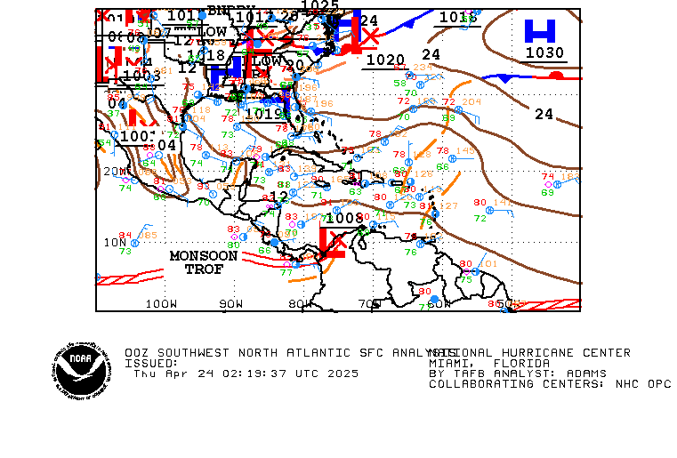
#115 Postby cycloneye » Thu Jul 15, 2010 10:09 pm

00z Surface Analysis by TAFB:

Image
0 likes   
Visit the Caribbean-Central America Weather Thread where you can find at first post web cams,radars
and observations from Caribbean basin members Click Here

Wx_Warrior
Category 5
Category 5
Posts: 2718
Joined: Thu Aug 03, 2006 3:58 pm
Location: Beaumont, TX

Re: Models develop SW Caribbean system-Code Yellow

#116 Postby Wx_Warrior » Thu Jul 15, 2010 11:18 pm

0z gfs para 102h

Image
0 likes   

Wx_Warrior
Category 5
Category 5
Posts: 2718
Joined: Thu Aug 03, 2006 3:58 pm
Location: Beaumont, TX

Re: Models develop SW Caribbean system-Code Yellow

#117 Postby Wx_Warrior » Thu Jul 15, 2010 11:30 pm

gfs para 144h

Image
0 likes   

Wx_Warrior
Category 5
Category 5
Posts: 2718
Joined: Thu Aug 03, 2006 3:58 pm
Location: Beaumont, TX

Re: Models develop SW Caribbean system-Code Yellow

#118 Postby Wx_Warrior » Thu Jul 15, 2010 11:34 pm

last one:

168h gfs para 0z

Image
0 likes   

User avatar
Ivanhater
Storm2k Moderator
Storm2k Moderator
Posts: 11162
Age: 38
Joined: Fri Jul 01, 2005 8:25 am
Location: Pensacola

Re: Models develop SW Caribbean system-Code Yellow

#119 Postby Ivanhater » Thu Jul 15, 2010 11:35 pm

Quite a large system in the gulf...

Image
0 likes   
Michael

Wx_Warrior
Category 5
Category 5
Posts: 2718
Joined: Thu Aug 03, 2006 3:58 pm
Location: Beaumont, TX

Re: Models develop SW Caribbean system-Code Yellow

#120 Postby Wx_Warrior » Thu Jul 15, 2010 11:37 pm

large & messy...IE the other 2....let's see what the EURO has ot offer.

EDIT: gfs para has skipped development the last run then picked back up.
0 likes   


Return to “Talkin' Tropics”

Who is online

Users browsing this forum: Google [Bot], lilbump3000, Sunnydays, wwizard and 71 guests