Possible Development in the BOC (Is Invest 93L)
Moderator: S2k Moderators
Forum rules

The posts in this forum are NOT official forecasts and should not be used as such. They are just the opinion of the poster and may or may not be backed by sound meteorological data. They are NOT endorsed by any professional institution or STORM2K. For official information, please refer to products from the National Hurricane Center and National Weather Service.
-
DESTRUCTION5

- Category 5

- Posts: 4430
- Age: 44
- Joined: Wed Sep 03, 2003 11:25 am
- Location: Stuart, FL
-
SFLcane

- S2K Supporter

- Posts: 10281
- Age: 48
- Joined: Sat Jun 05, 2010 1:44 pm
- Location: Lake Worth Florida
Re:
Alyono wrote:how tropical is this? That looks like a frontal low based upon the SLP depiction
Regardless sub-tropical or not can still cause problems. needs to be watched especially for heavy rainfall potential. Reality most wont even know difference
Last edited by SFLcane on Sun Oct 19, 2014 5:33 pm, edited 1 time in total.
0 likes


-
cycloneye

- Admin

- Posts: 149283
- Age: 69
- Joined: Thu Oct 10, 2002 10:54 am
- Location: San Juan, Puerto Rico
Re: weather statement
sammy126 wrote:Should I be worried? I live in Sarasota county.https://www.facebook.com/pages/Sarasota-County-Emergency-Management/623466111005511?hc_location=timeline
I moved your post to this thread to not have duplicated threads about the same topic.
0 likes
Visit the Caribbean-Central America Weather Thread where you can find at first post web cams,radars
and observations from Caribbean basin members Click Here
and observations from Caribbean basin members Click Here

-
JKingTampa

- Tropical Storm

- Posts: 101
- Joined: Wed Sep 10, 2014 8:16 pm
- Location: St. Petersburg, FL

Re: Possible Development in the BOC
Who do we trust at this point, GFS further south or Euro further north?
GFS hasn't exactly been trustworthy this year, but is it more accurate in the short range once something HAS developed?
GFS hasn't exactly been trustworthy this year, but is it more accurate in the short range once something HAS developed?
0 likes
-
floridasun78
- Category 5
- Posts: 3755
- Joined: Sun May 17, 2009 10:16 pm
- Location: miami fl
-
jlauderdal
- S2K Supporter
- Posts: 7240
- Joined: Wed May 19, 2004 5:46 am
- Location: NE Fort Lauderdale
- Contact:
Re: Possible Development in the BOC
N2FSU wrote:Who do we trust at this point, GFS further south or Euro further north?
GFS hasn't exactly been trustworthy this year, but is it more accurate in the short range once something HAS developed?
i will make this easy...euro until further notice...enjoy the rain florida
0 likes
-
cycloneye
- Admin
- Posts: 149283
- Age: 69
- Joined: Thu Oct 10, 2002 10:54 am
- Location: San Juan, Puerto Rico
Re: Possible Development in the BOC
8 PM TWO:
A broad area of low pressure located over the extreme southwestern
Bay of Campeche is producing disorganized showers and thunderstorms.
Some gradual development of this system is possible during the next
several days while it moves east-northeastward at 5 to 10 mph.
* Formation chance through 48 hours...low...10 percent.
* Formation chance through 5 days...medium...30 percent.
0 likes
Visit the Caribbean-Central America Weather Thread where you can find at first post web cams,radars
and observations from Caribbean basin members Click Here
and observations from Caribbean basin members Click Here
-
SFLcane
- S2K Supporter
- Posts: 10281
- Age: 48
- Joined: Sat Jun 05, 2010 1:44 pm
- Location: Lake Worth Florida
Re: Possible Development in the BOC
joe b on twitter...
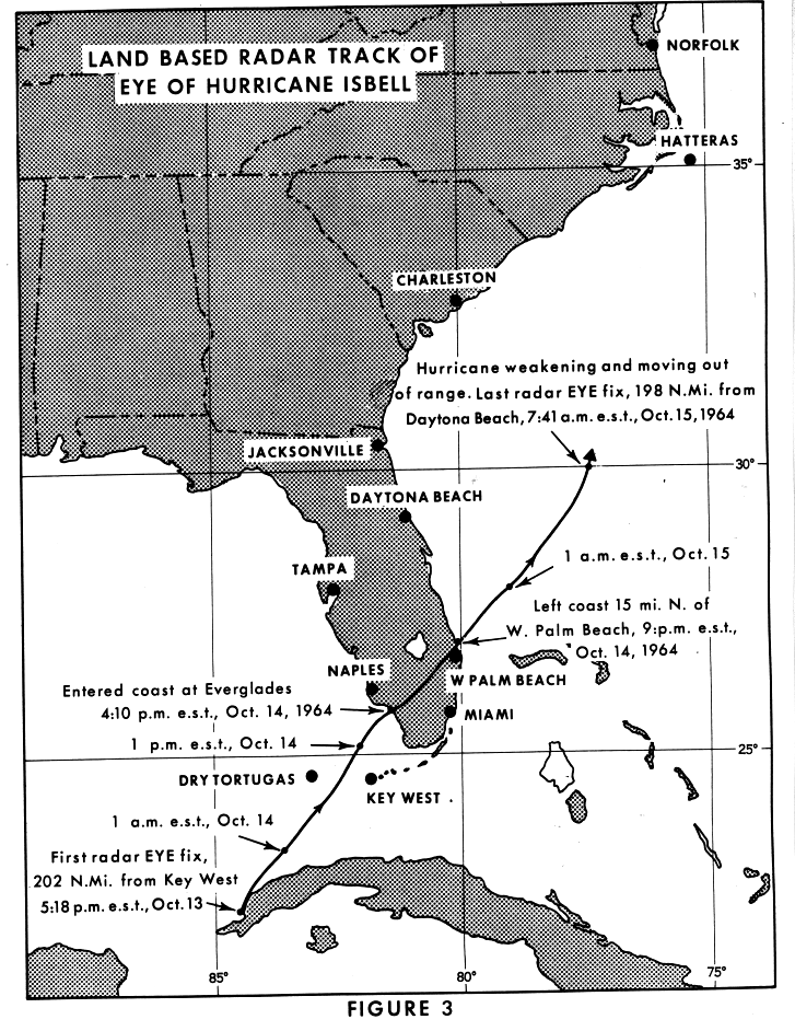
pm post on http://weatherbell.com showed members "Isbell" (1964) set up for Fla. 18z GFS went to it

pm post on http://weatherbell.com showed members "Isbell" (1964) set up for Fla. 18z GFS went to it
0 likes
-
HurricaneBelle

- S2K Supporter
- Posts: 1209
- Joined: Sun Aug 27, 2006 6:12 pm
- Location: Clearwater, FL
Forget Isbell, the analog I have in mind is Mitch from 1998. After it was a Cat 5 and devastated Honduras, it kind of died in Mexico and then reformed in the extreme southern Bay of Campeche and moved ENE as a sheared 55-MPH TS across South Florida during the first week in November.
http://en.wikipedia.org/wiki/Hurricane_ ... infall.gif
http://en.wikipedia.org/wiki/Hurricane_ ... infall.gif
0 likes
-
jlauderdal
- S2K Supporter
- Posts: 7240
- Joined: Wed May 19, 2004 5:46 am
- Location: NE Fort Lauderdale
- Contact:
Re: Possible Development in the BOC
HurricaneBelle wrote:Forget Isbell, the analog I have in mind is Mitch from 1998. After it was a Cat 5 and devastated Honduras, it kind of died in Mexico and then reformed in the extreme southern Bay of Campeche and moved ENE as a sheared 55-MPH TS across South Florida during the first week in November.
http://en.wikipedia.org/wiki/Hurricane_ ... infall.gif
mitch was a nasty storm..no debate about that
0 likes


-
Hurricane Alexis

- Category 2

- Posts: 683
- Age: 29
- Joined: Thu Jun 14, 2012 7:59 pm
- Location: Miami,Florida
Re:
Alyono wrote:thats not even subtropical, that is frontal. Look at the precip pattern. There is a clear front extending from the system
How different are the impacts from a frontal low rather than a tropical or sub-tropical one?
0 likes
Personal Forecast Disclaimer:
The posts in this forum are NOT official forecast and should not be used as such. They are just the opinion of the poster and may or may not be backed by sound meteorological data. They are NOT endorsed by any professional institution or storm2k.org. For official information, please refer to the NHC and NWS products.
The posts in this forum are NOT official forecast and should not be used as such. They are just the opinion of the poster and may or may not be backed by sound meteorological data. They are NOT endorsed by any professional institution or storm2k.org. For official information, please refer to the NHC and NWS products.

Re: Possible Development in the BOC
I've seen that low on Florida so many times this year, and nothing has come of any of them. It makes it hard for me to take that seriously although I know anything can happen.
0 likes
-
jlauderdal
- S2K Supporter
- Posts: 7240
- Joined: Wed May 19, 2004 5:46 am
- Location: NE Fort Lauderdale
- Contact:
Re: Possible Development in the BOC
sunnyday wrote:I've seen that low on Florida so many times this year, and nothing has come of any of them. It makes it hard for me to take that seriously although I know anything can happen.
south florida gets hit alot in the gfs world
0 likes

Re: Possible Development in the BOC
sunnyday wrote:I've seen that low on Florida so many times this year, and nothing has come of any of them. It makes it hard for me to take that seriously although I know anything can happen.
Euro has never showed it before now.
That said, this could be a possible analog as far as track/intensity, if the Euro is any indication

0 likes
The above post is not official and should not be used as such. It is the opinion of the poster and may or may not be backed by sound meteorological data. It is not endorsed by any professional institution or storm2k.org. For official information, please refer to the NHC and NWS products.
Who is online
Users browsing this forum: Yellow Evan and 117 guests