Low pressure to organize over the Southwestern Gulf of Mexico (Is INVEST 91L)

This is the general tropical discussion area. Anyone can take their shot at predicting a storms path.

Moderator: S2k Moderators

Forum rules

The posts in this forum are NOT official forecasts and should not be used as such. They are just the opinion of the poster and may or may not be backed by sound meteorological data. They are NOT endorsed by any professional institution or STORM2K. For official information, please refer to products from the National Hurricane Center and National Weather Service.

Help Support Storm2K
Message
Author
sphelps8681
Category 2
Category 2
Posts: 785
Joined: Thu Aug 16, 2007 5:37 pm
Location: Somewhere over the rainbow

Re: Low pressure to organize over the Southwestern Gulf of Mexico (30/70)

#101 Postby sphelps8681 » Sun Jun 16, 2024 5:49 pm

Cpv17 wrote:
sphelps8681 wrote:I live in Lumberton Tx 20 mins from Beaumont. We have been getting some bad weather lately here in the area. So great more rain if this storm becomes a TD or TS. Thanks for the updates.


Lumberton almost always gets plenty of rain. Very rarely is lack of rain an issue there.


I live down the street on my road from the Neches river. We have to go down and check levels. The last storms we got had people evacuating down there.
0 likes   

User avatar
South Texas Storms
Professional-Met
Professional-Met
Posts: 4197
Joined: Thu Jun 24, 2010 12:28 am
Location: Houston, TX

Re: Low pressure to organize over the Southwestern Gulf of Mexico (30/70)

#102 Postby South Texas Storms » Sun Jun 16, 2024 5:52 pm

Portastorm wrote:Areas of southeast Texas are still flooded by earlier spring rains and haven't recovered from those events. I'm very concerned about copious amounts of tropical moisture falling on those same areas and making a bad situation even worse.

If anyone is asking, I'd gladly take some of that tropical moisture along the I-35 corridor for Austin and San Antonio.


Yeah Porta, SA, Austin and the Hill Country still really need the rain. Lake levels are so low across the region. A good soaking from a tropical system like this would be so beneficial for us.
1 likes   

utweather
Category 1
Category 1
Posts: 252
Joined: Tue Jan 26, 2010 10:51 pm
Location: SE Austin, TX

Re: Low pressure to organize over the Southwestern Gulf of Mexico (30/70)

#103 Postby utweather » Sun Jun 16, 2024 6:09 pm

Portastorm wrote:Areas of southeast Texas are still flooded by earlier spring rains and haven't recovered from those events. I'm very concerned about copious amounts of tropical moisture falling on those same areas and making a bad situation even worse.

If anyone is asking, I'd gladly take some of that tropical moisture along the I-35 corridor for Austin and San Antonio
.


Tropical clouds are cool to look at and rains without wind and hail are a win.
1 likes   

User avatar
cycloneye
Admin
Admin
Posts: 143861
Age: 68
Joined: Thu Oct 10, 2002 10:54 am
Location: San Juan, Puerto Rico

Re: Low pressure to organize over the Southwestern Gulf of Mexico (50/70)

#104 Postby cycloneye » Sun Jun 16, 2024 6:15 pm

8 PM:

Southwestern Gulf of Mexico:
A large area of disturbed weather is located over Central America,
the Yucatan Peninsula of Mexico, and the adjacent waters of the
northwestern Caribbean Sea and southern Gulf of Mexico. A broad
area of low pressure is forecast to form from this system over the
southwestern Gulf of Mexico within the next day or so.
Environmental conditions appear conducive for subsequent gradual
development of the low, and a tropical depression or tropical storm
is likely to form by midweek while it moves slowly westward or
west-northwestward toward the western Gulf coast.

Regardless of development, several days of heavy rainfall are
expected across portions of southern Mexico and Central America, and
these rains are likely to cause life-threatening flooding and flash
flooding. Locally heavy rainfall is also expected to spread over
portions of the northwestern coast of the Gulf of Mexico by the
middle of the week. In addition, gale warnings have been issued
for portions of the Gulf of Mexico, and more information on
those warnings is available in High Seas Forecasts issued by the
National Weather Service.
* Formation chance through 48 hours...medium...50 percent.
* Formation chance through 7 days...high...70 percent.
1 likes   
Visit the Caribbean-Central America Weather Thread where you can find at first post web cams,radars
and observations from Caribbean basin members Click Here

User avatar
mpic
S2K Supporter
S2K Supporter
Posts: 619
Joined: Thu Oct 20, 2005 11:24 am
Location: Splendora, TX

Re: Low pressure to organize over the Southwestern Gulf of Mexico (50/70)

#105 Postby mpic » Sun Jun 16, 2024 6:37 pm

Has there ever been many times when a storm that originated down there didn't end up going northeast or at least affecting southeast Texas/Louisiana? I started getting ready the minute it showed up. In my mind, there's a reason June 1st starts hurricane season and there have been plenty of tropical events that may as well have been hurricanes with the amount of rain that fell. My ground is still saturated after the last 2.5 months of rain so that I am barely able to mow and ditches still have water.
0 likes   
Alicia, Rita, Ike, Harvey and Beryl...moved to Splendora lol

User avatar
Cpv17
Category 5
Category 5
Posts: 4914
Joined: Wed Dec 07, 2016 2:24 pm
Location: Wharton/El Campo, TX

Re: Low pressure to organize over the Southwestern Gulf of Mexico (50/70)

#106 Postby Cpv17 » Sun Jun 16, 2024 6:51 pm

mpic wrote:Has there ever been many times when a storm that originated down there didn't end up going northeast or at least affecting southeast Texas/Louisiana? I started getting ready the minute it showed up. In my mind, there's a reason June 1st starts hurricane season and there have been plenty of tropical events that may as well have been hurricanes with the amount of rain that fell. My ground is still saturated after the last 2.5 months of rain so that I am barely able to mow and ditches still have water.


Most systems that form in the Gulf during June are sheared systems. So the rain is mostly displaced well away from the center.
1 likes   

User avatar
skyline385
Category 5
Category 5
Posts: 2728
Age: 34
Joined: Wed Aug 26, 2020 11:15 pm
Location: Houston TX

Re: Low pressure to organize over the Southwestern Gulf of Mexico (50/70)

#107 Postby skyline385 » Sun Jun 16, 2024 8:48 pm

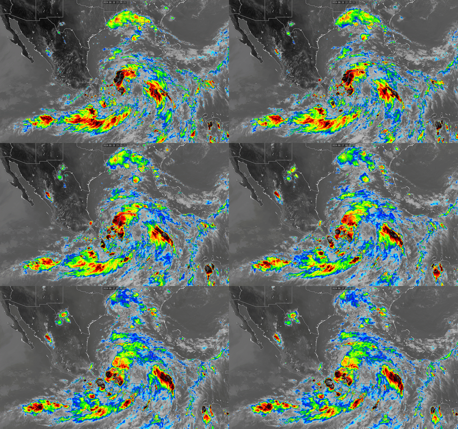
The size of the CAG is pretty incredible

Image
9 likes   

Wampadawg
Tropical Storm
Tropical Storm
Posts: 235
Joined: Wed Oct 14, 2020 10:28 am
Location: South Texas

Re: Low pressure to organize over the Southwestern Gulf of Mexico (50/70)

#108 Postby Wampadawg » Sun Jun 16, 2024 8:58 pm

skyline385 wrote:The size of the CAG is pretty incredible

[url]https://i.postimg.cc/Qtk9YwKw/G16-ABI-FD-BAND13-GRAD-20240616-224021-1.gif [/url]

You can say that again
0 likes   
Harvey,Hanna,Beta,Texas Winter storm2021,Nicholas,Beryl

User avatar
Category5Kaiju
Category 5
Category 5
Posts: 4051
Joined: Thu Dec 24, 2020 12:45 pm
Location: Seattle

Re: Low pressure to organize over the Southwestern Gulf of Mexico (50/70)

#109 Postby Category5Kaiju » Sun Jun 16, 2024 10:28 pm

skyline385 wrote:The size of the CAG is pretty incredible

[url]https://i.postimg.cc/Qtk9YwKw/G16-ABI-FD-BAND13-GRAD-20240616-224021-1.gif [/url]


It definitely has that "look." That "look" that it's about to generate a TC soon.
0 likes   
Unless explicitly stated, all info in my posts is based on my own opinions and observations. Tropical storms and hurricanes can be extremely dangerous. Do not think you can beat Mother Nature. Refer to an accredited weather research agency or meteorologist if you need to make serious decisions regarding an approaching storm.

LarryWx
Category 5
Category 5
Posts: 6246
Joined: Sun Sep 07, 2003 2:04 pm
Location: GA

Re: Low pressure to organize over the Southwestern Gulf of Mexico (50/70)

#110 Postby LarryWx » Sun Jun 16, 2024 11:50 pm

0Z UKMET: a little further north than the 12Z run; still has a TS
NEW TROPICAL CYCLONE FORECAST TO DEVELOP AFTER 54 HOURS
FORECAST POSITION AT T+ 54 : 23.6N 94.4W

LEAD CENTRAL MAXIMUM WIND
VERIFYING TIME TIME POSITION PRESSURE (MB) SPEED (KNOTS)
-------------- ---- -------- ------------- -------------
1200UTC 19.06.2024 60 23.5N 94.7W 998 35
0000UTC 20.06.2024 72 23.4N 95.6W 997 39
1200UTC 20.06.2024 84 24.9N 97.9W 999 38
0000UTC 21.06.2024 96 CEASED TRACKING
0 likes   
Personal Forecast Disclaimer:
The posts in this forum are NOT official forecasts and should not be used as such. They are just the opinion of the poster and may or may not be backed by sound meteorological data. They are NOT endorsed by any professional institution or storm2k.org. For official information, please refer to the NHC and NWS products.

User avatar
REDHurricane
Category 1
Category 1
Posts: 394
Age: 27
Joined: Sun Jul 03, 2022 2:36 pm
Location: Northeast Pacific Ocean

Re: Low pressure to organize over the Southwestern Gulf of Mexico (50/70)

#111 Postby REDHurricane » Mon Jun 17, 2024 4:03 am

Image

Image

Woof :eek:
1 likes   

User avatar
cycloneye
Admin
Admin
Posts: 143861
Age: 68
Joined: Thu Oct 10, 2002 10:54 am
Location: San Juan, Puerto Rico

Re: Low pressure to organize over the Southwestern Gulf of Mexico (70/70)

#112 Postby cycloneye » Mon Jun 17, 2024 6:42 am

Southwestern Gulf of Mexico:
Satellite imagery and surface observations indicate that a broad
area of low pressure is forming over the Bay of Campeche.
Environmental conditions appear conducive for additional gradual
development, and a tropical depression or tropical storm is likely
to form by midweek while it moves slowly westward or
west-northwestward toward the western Gulf coast.

Regardless of development, several days of heavy rainfall are
expected across portions of southern Mexico and Central America, and
these rains are likely to cause life-threatening flooding and flash
flooding. Locally heavy rainfall is also expected to spread over
portions of the northwestern coast of the Gulf of Mexico by the
middle of the week. In addition, gale warnings have been issued for
portions of the Gulf of Mexico, and more information on those
warnings is available in High Seas Forecasts issued by the National
Weather Service. Interests along the western and northwestern Gulf
coasts should monitor the progress of this system. An Air Force
Reserve Hurricane Hunter aircraft is scheduled to investigate the
system later today.
* Formation chance through 48 hours...high...70 percent.
* Formation chance through 7 days...high...70 percent.
0 likes   
Visit the Caribbean-Central America Weather Thread where you can find at first post web cams,radars
and observations from Caribbean basin members Click Here

User avatar
wxman57
Moderator-Pro Met
Moderator-Pro Met
Posts: 22950
Age: 67
Joined: Sat Jun 21, 2003 8:06 pm
Location: Houston, TX (southwest)

Re: Low pressure to organize over the Southwestern Gulf of Mexico (70/70)

#113 Postby wxman57 » Mon Jun 17, 2024 7:13 am

NHC should be starting PTC advisories today, as TS watches will be needed since TS coastal winds are within 48 hrs
1 likes   

User avatar
NDG
S2K Supporter
S2K Supporter
Posts: 15444
Joined: Sun Jul 09, 2006 10:14 pm
Location: Orlando, FL

Re: Low pressure to organize over the Southwestern Gulf of Mexico (70/70)

#114 Postby NDG » Mon Jun 17, 2024 7:25 am

COC appears to be barely offshore, appears to be broad at this time but pressures in the area continue to drop.
Ciudad del Carmen reports a pressure of 1001mb, a 6 mb drop from 24 hrs ago.
3 likes   

User avatar
cycloneye
Admin
Admin
Posts: 143861
Age: 68
Joined: Thu Oct 10, 2002 10:54 am
Location: San Juan, Puerto Rico

Re: Low pressure to organize over the Southwestern Gulf of Mexico (Is INVEST 91L)

#115 Postby cycloneye » Mon Jun 17, 2024 7:39 am

0 likes   
Visit the Caribbean-Central America Weather Thread where you can find at first post web cams,radars
and observations from Caribbean basin members Click Here


Return to “Talkin' Tropics”

Who is online

Users browsing this forum: Google Adsense [Bot], Hurricane2022, Kingarabian, riapal, Teban54 and 75 guests