12z GFS has a future MH Karen forming off the northeastern tip of the Yucatan at +168 hrs, then meandering around the western Gulf for a week+
Still hasn't actually gotten anywhere at +342 hrs in the model that's still running.
2025 Global Model Runs Discussion (Out thru day 16)
Moderator: S2k Moderators
Forum rules

The posts in this forum are NOT official forecasts and should not be used as such. They are just the opinion of the poster and may or may not be backed by sound meteorological data. They are NOT endorsed by any professional institution or STORM2K. For official information, please refer to products from the National Hurricane Center and National Weather Service.
-
TampaWxLurker
- Tropical Storm

- Posts: 196
- Joined: Thu Aug 01, 2024 8:20 am

Re: 2025 Global Model Runs Discussion (Out thru day 16)
TampaWxLurker wrote:12z GFS has a future MH Karen forming off the northeastern tip of the Yucatan at +168 hrs, then meandering around the western Gulf for a week+
Still hasn't actually gotten anywhere at +342 hrs in the model that's still running.
I believe that’s the new lowriding wave some models have been showing.
1 likes
Igor 2010, Sandy 2012, Fay 2014, Gonzalo 2014, Joaquin 2015, Nicole 2016, Humberto 2019, Imelda 2025
I am only a tropical weather enthusiast. My predictions are not official and may or may not be backed by sound meteorological data. For official information, please refer to the NHC and NWS products.
I am only a tropical weather enthusiast. My predictions are not official and may or may not be backed by sound meteorological data. For official information, please refer to the NHC and NWS products.

Re: 2025 Global Model Runs Discussion (Out thru day 16)
TampaWxLurker wrote:12z GFS has a future MH Karen forming off the northeastern tip of the Yucatan at +168 hrs, then meandering around the western Gulf for a week+
Still hasn't actually gotten anywhere at +342 hrs in the model that's still running.
I’m pretty sure Karen will be taken by the East Coast storm in a few days so that will likely be L
1 likes
Re: 2025 Global Model Runs Discussion (Out thru day 16)
Fancy1002 wrote:TampaWxLurker wrote:12z GFS has a future MH Karen forming off the northeastern tip of the Yucatan at +168 hrs, then meandering around the western Gulf for a week+
Still hasn't actually gotten anywhere at +342 hrs in the model that's still running.
I’m pretty sure Karen will be taken by the East Coast storm in a few days so that will likely be L
1. But that’s only if the NHC were to classify it as a subtropical storm. They may, but so far there’s not even been a mention of it in the TWO.
2. OTOH, 96L has been mentioned in the TWOs as having a chance for subtropical or tropical development, either of which would earn it a name.
3 likes
Personal Forecast Disclaimer:
The posts in this forum are NOT official forecasts and should not be used as such. They are just the opinion of the poster and may or may not be backed by sound meteorological data. They are NOT endorsed by any professional institution or storm2k.org. For official information, please refer to the NHC and NWS products.
The posts in this forum are NOT official forecasts and should not be used as such. They are just the opinion of the poster and may or may not be backed by sound meteorological data. They are NOT endorsed by any professional institution or storm2k.org. For official information, please refer to the NHC and NWS products.
-
AnnularCane

- S2K Supporter

- Posts: 2957
- Joined: Thu Jun 08, 2006 9:18 am
- Location: Wytheville, VA
Re: 2025 Global Model Runs Discussion (Out thru day 16)
TampaWxLurker wrote:12z GFS has a future MH Karen forming off the northeastern tip of the Yucatan at +168 hrs, then meandering around the western Gulf for a week+
Still hasn't actually gotten anywhere at +342 hrs in the model that's still running.
Almost does an Isidore there.
Runs over the mouth of the Mississippi and then the FL panhandle.

1 likes
"But it never rained rain. It never snowed snow. And it never blew just wind. It rained things like soup and juice. It snowed mashed potatoes and green peas. And sometimes the wind blew in storms of hamburgers." -- Judi Barrett, Cloudy with a Chance of Meatballs
-
Ivanhater

- Storm2k Moderator

- Posts: 11221
- Age: 39
- Joined: Fri Jul 01, 2005 8:25 am
- Location: Pensacola
Re: 2025 Global Model Runs Discussion (Out thru day 16)
AnnularCane wrote:TampaWxLurker wrote:12z GFS has a future MH Karen forming off the northeastern tip of the Yucatan at +168 hrs, then meandering around the western Gulf for a week+
Still hasn't actually gotten anywhere at +342 hrs in the model that's still running.
Almost does an Isidore there.
Runs over the mouth of the Mississippi and then the FL panhandle.
Common track for October
4 likes
Michael
-
TheDreamTraveler

- Category 2

- Posts: 645
- Joined: Sun Aug 22, 2010 3:10 am
- Location: PA
Re: 2025 Global Model Runs Discussion (Out thru day 16)
Fancy1002 wrote:TampaWxLurker wrote:12z GFS has a future MH Karen forming off the northeastern tip of the Yucatan at +168 hrs, then meandering around the western Gulf for a week+
Still hasn't actually gotten anywhere at +342 hrs in the model that's still running.
I’m pretty sure Karen will be taken by the East Coast storm in a few days so that will likely be L
Funnily enough neither of those 2 storms took the Karen name and instead that one way north east in the Atlantic did
1 likes
-
cycloneye

- Admin

- Posts: 149261
- Age: 69
- Joined: Thu Oct 10, 2002 10:54 am
- Location: San Juan, Puerto Rico
Re: 2025 Global Model Runs Discussion (Out thru day 16)
12z GFS on long range with East-Central Caribbean Sea area.

0 likes
Visit the Caribbean-Central America Weather Thread where you can find at first post web cams,radars
and observations from Caribbean basin members Click Here
and observations from Caribbean basin members Click Here
-
cycloneye
- Admin
- Posts: 149261
- Age: 69
- Joined: Thu Oct 10, 2002 10:54 am
- Location: San Juan, Puerto Rico
Re: 2025 Global Model Runs Discussion (Out thru day 16)
Whoa, AI Deepmind has also activity in Caribbean.

4 likes
Visit the Caribbean-Central America Weather Thread where you can find at first post web cams,radars
and observations from Caribbean basin members Click Here
and observations from Caribbean basin members Click Here
Re: 2025 Global Model Runs Discussion (Out thru day 16)
The happy hour GFS does too…
0 likes
Igor 2010, Sandy 2012, Fay 2014, Gonzalo 2014, Joaquin 2015, Nicole 2016, Humberto 2019, Imelda 2025
I am only a tropical weather enthusiast. My predictions are not official and may or may not be backed by sound meteorological data. For official information, please refer to the NHC and NWS products.
I am only a tropical weather enthusiast. My predictions are not official and may or may not be backed by sound meteorological data. For official information, please refer to the NHC and NWS products.
-
DorkyMcDorkface

- Category 4

- Posts: 984
- Age: 28
- Joined: Mon Sep 30, 2019 1:32 pm
- Location: Mid-Atlantic
Re: 2025 Global Model Runs Discussion (Out thru day 16)
Looking past sloppy Jerry...18z GFS develops those two waves the EPS has been interested in the past few days.

2 likes
Please note the thougths expressed by this account are solely those of the user and are from a hobbyist perspective. For more comprehensive analysis, consult an actual professional meteorologist or meteorology agency.
Floyd 1999 | Isabel 2003 | Hanna 2008 | Irene 2011 | Sandy 2012 | Isaias 2020
-
Category5Kaiju

- Category 5

- Posts: 4330
- Joined: Thu Dec 24, 2020 12:45 pm
- Location: Seattle and Phoenix
Re: 2025 Global Model Runs Discussion (Out thru day 16)
Ngl, with storm after storm this year turning out to sea, it does feel somewhat odd to see some of these long-range models, especially the deepmind AI ones, showing a possible signal in the ECAR later this month. The absolute hotspot for activity this year has been the Sargasso Sea....but will this season manage to produce something noteworthy in the Caribbean or Gulf before the end? We shall see.
1 likes
Unless explicitly stated, all info in my posts is based on my own opinions and observations. Tropical storms and hurricanes can be extremely dangerous. Refer to an accredited weather research agency or meteorologist if you need to make serious decisions regarding an approaching storm.
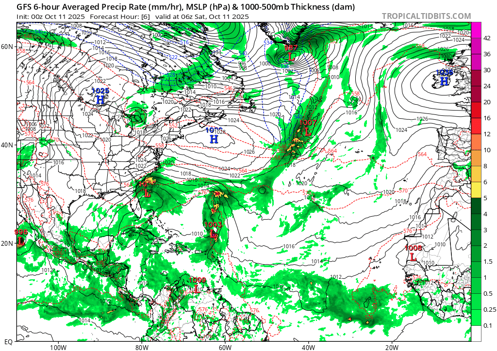
Re: 2025 Global Model Runs Discussion (Out thru day 16)
The end of the 00z gfs is looking scary for florida.
Looks to be taking the Ian/charley route, or maybe Miami
Looks to be taking the Ian/charley route, or maybe Miami
0 likes
Re: 2025 Global Model Runs Discussion (Out thru day 16)
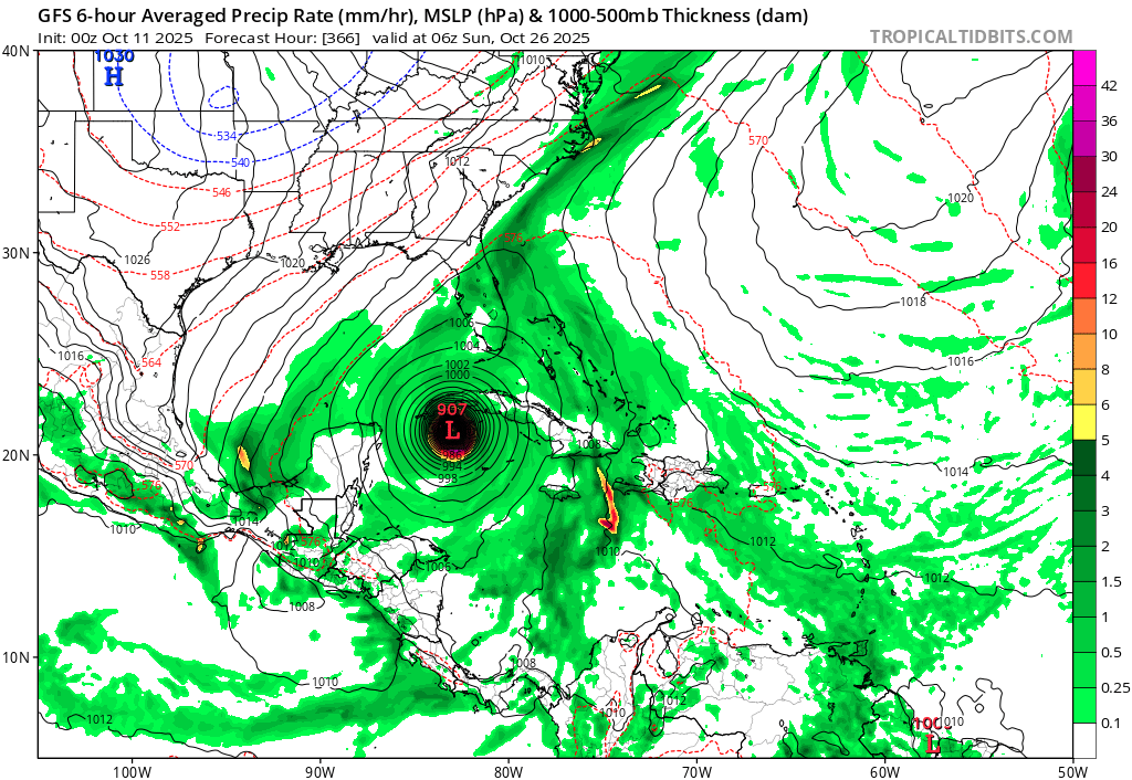
GFS 00z run decided to go absolutely nuts. Of course, this is fantasy land, so this is probably not going to happen (although that second low rider wave does seem concerning). Let's hope this doesn't happen since this is nightmare fuel, especially since that area of the basin hasn't been touched all year.
2 likes
Re: 2025 Global Model Runs Discussion (Out thru day 16)
zhukm29 wrote:GFS 00z run decided to go absolutely nuts. Of course, this is fantasy land, so this is probably not going to happen (although that second low rider wave does seem concerning). Let's hope this doesn't happen since this is nightmare fuel, especially since that area of the basin hasn't been touched all year.
https://i.postimg.cc/Fs0bVRgQ/gfs-mslp-pcpn-atl-fh6-384-2.gif
https://i.postimg.cc/KzsK57wJ/gfs-mslp-pcpn-watl-61.png
https://i.postimg.cc/fTd3x9KB/image-1.webp
That’s such a cool looking boundary of storms to its north
0 likes
-
ConvergenceZone
.gif)
- Category 5
- Posts: 5241
- Joined: Fri Jul 29, 2005 1:40 am
- Location: Northern California
Re: 2025 Global Model Runs Discussion (Out thru day 16)
zhukm29 wrote:GFS 00z run decided to go absolutely nuts. Of course, this is fantasy land, so this is probably not going to happen (although that second low rider wave does seem concerning). Let's hope this doesn't happen since this is nightmare fuel, especially since that area of the basin hasn't been touched all year.
https://i.postimg.cc/Fs0bVRgQ/gfs-mslp-pcpn-atl-fh6-384-2.gif
https://i.postimg.cc/KzsK57wJ/gfs-mslp-pcpn-watl-61.png
https://i.postimg.cc/fTd3x9KB/image-1.webp
GFS has been abysmal this year. It's honestly been so bad that I don't even pay attention to it anymore. It's had more happy hour catastrophic runs this year of storms that just popped out of nowhere than any other year I can remember. It's fun to get a chuckle out of though. I'm sure the other models get a laugh of it also. GFS reminds of the kid in school that loved to show off only to fall flat on his face later.
0 likes

Re: 2025 Global Model Runs Discussion (Out thru day 16)
ConvergenceZone wrote:zhukm29 wrote:GFS 00z run decided to go absolutely nuts. Of course, this is fantasy land, so this is probably not going to happen (although that second low rider wave does seem concerning). Let's hope this doesn't happen since this is nightmare fuel, especially since that area of the basin hasn't been touched all year.
https://i.postimg.cc/Fs0bVRgQ/gfs-mslp-pcpn-atl-fh6-384-2.gif
https://i.postimg.cc/KzsK57wJ/gfs-mslp-pcpn-watl-61.png
https://i.postimg.cc/fTd3x9KB/image-1.webp
GFS has been abysmal this year. It's honestly been so bad that I don't even pay attention to it anymore. It's had more happy hour catastrophic runs this year of storms that just popped out of nowhere than any other year I can remember. It's fun to get a chuckle out of though. I'm sure the other models get a laugh of it also. GFS reminds of the kid in school that loved to show off only to fall flat on his face later.
Yeah it'll probably be gone the next run, but this at least seems to come from an actual wave that is expected to come off of Africa and not just some spurious vorticity that pops out of nowhere. AEWs that form in late October typically never reach the US though, so this specific path is probably unlikely and is just for entertainment purposes.
1 likes
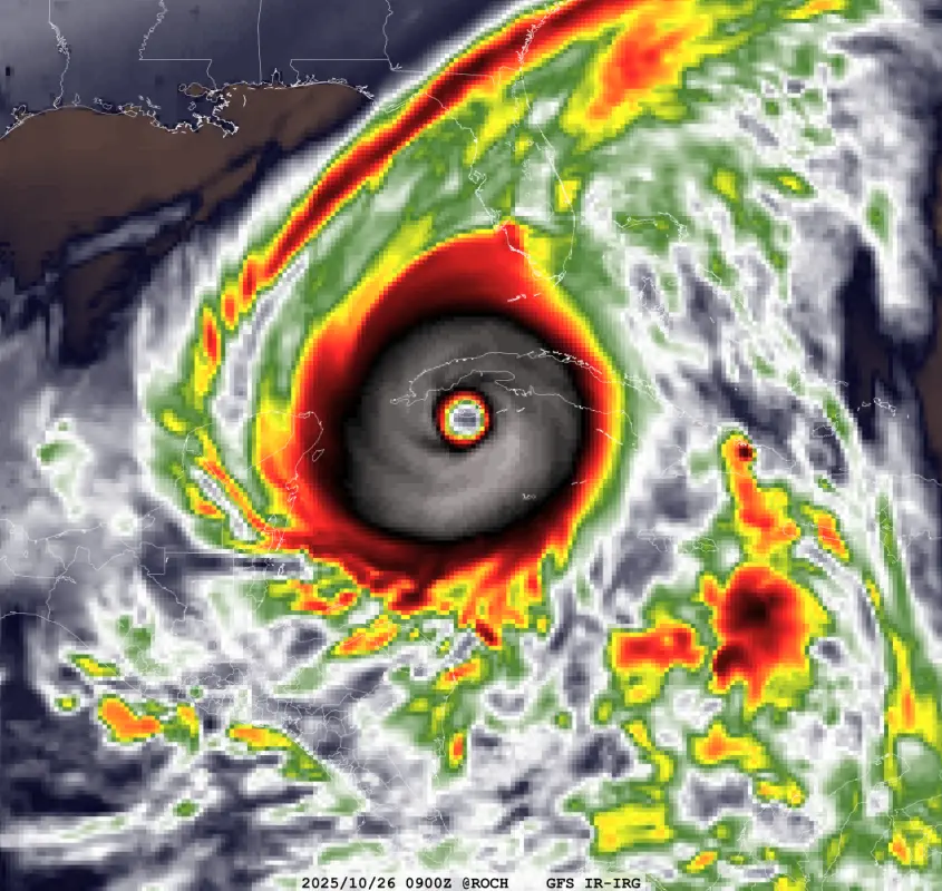
Re: 2025 Global Model Runs Discussion (Out thru day 16)
Sharing the simulated IR satellite for this insane run for posterity, in case someone from the future wanted to see how crazy the GFS was:
1 likes
-
ElectricStorm

- Category 5
- Posts: 5139
- Age: 25
- Joined: Tue Aug 13, 2019 11:23 pm
- Location: Norman, OK
Re: 2025 Global Model Runs Discussion (Out thru day 16)
Obviously this 907mb GFS run is likely out to lunch, but it's worth noting this wave appears on the 12z Euro, as well as the 0z ICON and CMC to an extent, so this upcoming wave will definitely need to be watched. Especially it stays weaker initially and makes its way further west before developing (if at all)
1 likes
B.S Meteorology, University of Oklahoma '25
Please refer to the NHC, NWS, or SPC for official information.
Please refer to the NHC, NWS, or SPC for official information.
Who is online
Users browsing this forum: No registered users and 90 guests