
It looks like the low is now stationary.
http://www.ssd.noaa.gov/goes/east/watl/loop-rb.html
http://www.ssd.noaa.gov/goes/east/watl/loop-vis.html
Low Pressure in Gulf of Mexico
Moderator: S2k Moderators
Forum rules

The posts in this forum are NOT official forecasts and should not be used as such. They are just the opinion of the poster and may or may not be backed by sound meteorological data. They are NOT endorsed by any professional institution or STORM2K. For official information, please refer to products from the National Hurricane Center and National Weather Service.


-
brunota2003

- S2K Supporter

- Posts: 9476
- Age: 35
- Joined: Sat Jul 30, 2005 9:56 pm
- Location: Stanton, KY...formerly Havelock, NC
- Contact:

Re: Low Pressure in Gulf of Mexico
Check out the difference in the 200 mb Vorticty ite last 24 hrs.
yesterday
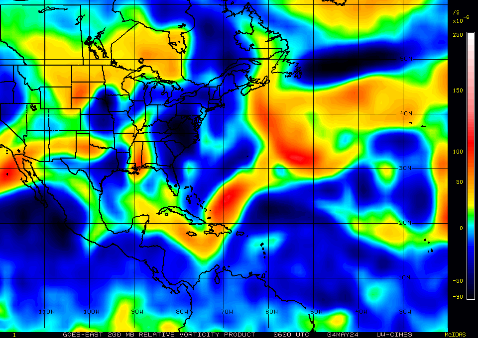
today


I think it deserves a bear watch
yesterday
today
I think it deserves a bear watch
Last edited by tailgater on Thu May 21, 2009 11:58 am, edited 1 time in total.
0 likes


-
tolakram
- Admin

- Posts: 20168
- Age: 62
- Joined: Sun Aug 27, 2006 8:23 pm
- Location: Florence, KY (name is Mark)
Re: Low Pressure in Gulf of Mexico
Sure does appear to be making a slow transition to something, let's say, less than non tropical. 
http://hadar.cira.colostate.edu/ramsdis ... ive_0.html

http://hadar.cira.colostate.edu/ramsdis ... ive_0.html
0 likes
-
cycloneye

- Admin
- Posts: 148737
- Age: 69
- Joined: Thu Oct 10, 2002 10:54 am
- Location: San Juan, Puerto Rico
Re: Low Pressure in Gulf of Mexico
If it continues to organize,I would not rule out a invest tagged this afternoon or evening.
0 likes
-
Stormcenter
- S2K Supporter
- Posts: 6685
- Joined: Wed Sep 03, 2003 11:27 am
- Location: Houston, TX
Re:
I mentioned the same things (more northerly trackand very slow movement) in an early post. Anyway it really still does look sickly. The water only gets cooler as it heads more north. Oh well we shall see.
brunota2003 wrote:The low appears to be moving to the NNW at about 5 mph (guesstimate, maybe less). There is also some convection starting to go up on the NW side of the low. Will be interesting to watch to see if it just dies, or if the convection keeps developing.
0 likes
-
Stormcenter
- S2K Supporter
- Posts: 6685
- Joined: Wed Sep 03, 2003 11:27 am
- Location: Houston, TX
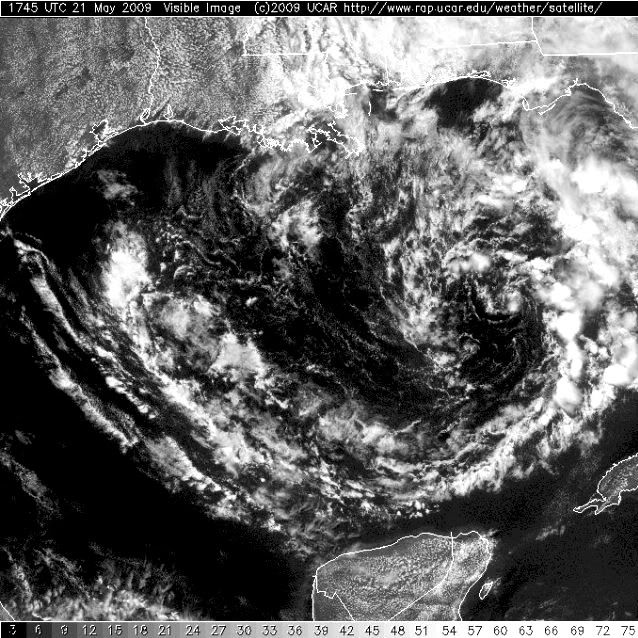
Re: Low Pressure in Gulf of Mexico
It sure looks like it's headed on a more northerly track.
I'm not so sure this is going to make landfall on the SE LA. coastline.
It looks more like maybe MS. and eastward.
http://www.ssd.noaa.gov/goes/east/gmex/loop-vis.html
I'm not so sure this is going to make landfall on the SE LA. coastline.
It looks more like maybe MS. and eastward.
http://www.ssd.noaa.gov/goes/east/gmex/loop-vis.html
Last edited by Stormcenter on Thu May 21, 2009 12:28 pm, edited 1 time in total.
0 likes
Re: Low Pressure in Gulf of Mexico
It is holding it's own and that's about it for the moment to me at least.The fact that we have 20kt shear over it now is making it tough to keep any convection to futher aide the engine.I think we along the NGOM be in for some fun winds and rain just a PIA it's on Memorial W/E 
0 likes

Re: Low Pressure in Gulf of Mexico
[quote="Javlin"]It is holding it's own and that's about it for the moment to me at least.The fact that we have 20kt shear over it now is making it tough to keep any convection to futher aide the engine.I think we along the NGOM be in for some fun winds and rain just a PIA it's on Memorial W/E [/quote]
I think folks on the Mississippi and Alabama Gulf Coasts are going to be in for some heavy rain this weekend no matter if it makes it to LA or a little more east of that
[/quote]I think folks on the Mississippi and Alabama Gulf Coasts are going to be in for some heavy rain this weekend no matter if it makes it to LA or a little more east of that
0 likes
-
HURAKAN

- Professional-Met

- Posts: 46086
- Age: 38
- Joined: Thu May 20, 2004 4:34 pm
- Location: Key West, FL
- Contact:
TROPICAL WEATHER DISCUSSION
NWS TPC/NATIONAL HURRICANE CENTER MIAMI FL
205 PM EDT THU MAY 21 2009
...DISCUSSION...
THE GULF OF MEXICO...
A 1006 MB LOW IS OVER THE E GULF OF MEXICO NEAR 26N86W. BANDS OF
WIDELY SCATTERED MODERATE CONVECTION ARE OVER THE NE GULF OF
MEXICO AND FLORIDA FROM 24N-29N BETWEEN 80W-86W. A TIGHT
PRESSURE GRADIENT OVER THE NE GULF IS PRODUCING 20-25 KT WINDS N
OF 27N E OF 90W. THE W GULF OF MEXICO W OF 90W HAS PARTLY CLOUDY
SKIES WITH 10-15 KT N WINDS. IN THE UPPER LEVELS...AN UPPER
LEVEL LOW IS CENTERED OVER THE E GULF NEAR 28N85W. THE NE GULF
AND FLORIDA HAS ABUNDANT UPPER AIR MOISTURE WHILE STRONG
SUBSIDENCE IS OVER THE REMAINDER OF THE GULF. EXPECT...THE
SURFACE LOW TO DRIFT NW TO THE CENTRAL GULF OF MEXICO OVER THE
NEXT 24 HOURS WITH CONVECTION MOSTLY N OF THE CENTER.
0 likes
-
Tampa Bay Hurricane

- Category 5

- Posts: 5598
- Age: 38
- Joined: Fri Jul 22, 2005 7:54 pm
- Location: St. Petersburg, FL
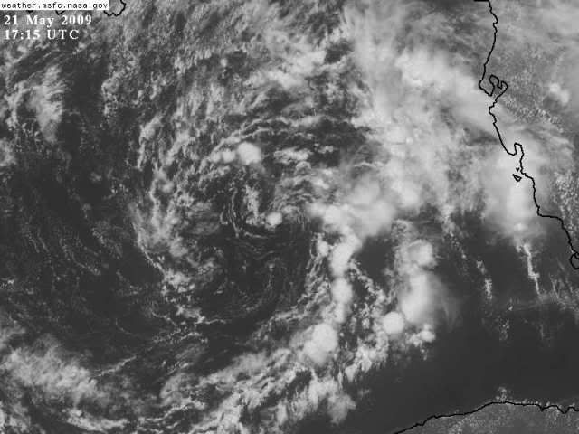
The heaviest spiral band of this low is right on the SW FL coast.
It does look like a slow transition to a tropical low is taking place.
Looks close to the loop current. I think we may get a minimal
tropical storm out of this IF it remains over the loop current.
Water temperatures of 78+ will maintain a minimal TS provided
shear is low.
It does look like a slow transition to a tropical low is taking place.
Looks close to the loop current. I think we may get a minimal
tropical storm out of this IF it remains over the loop current.
Water temperatures of 78+ will maintain a minimal TS provided
shear is low.
0 likes
-
Stormcenter
- S2K Supporter
- Posts: 6685
- Joined: Wed Sep 03, 2003 11:27 am
- Location: Houston, TX
Re:
An optimistic call (minimal TS) I must say but hey crazier things have happened.
By the way the Gale warnings along the LA. & MS, has been dropped.
By the way the Gale warnings along the LA. & MS, has been dropped.
Tampa Bay Hurricane wrote:The heaviest spiral band of this low is right on the SW FL coast.
It does look like a slow transition to a tropical low is taking place.
Looks close to the loop current. I think we may get a minimal
tropical storm out of this IF it remains over the loop current.
Water temperatures of 78+ will maintain a minimal TS provided
shear is low.
0 likes
-
Stormcenter
- S2K Supporter
- Posts: 6685
- Joined: Wed Sep 03, 2003 11:27 am
- Location: Houston, TX
Re: Low Pressure in Gulf of Mexico
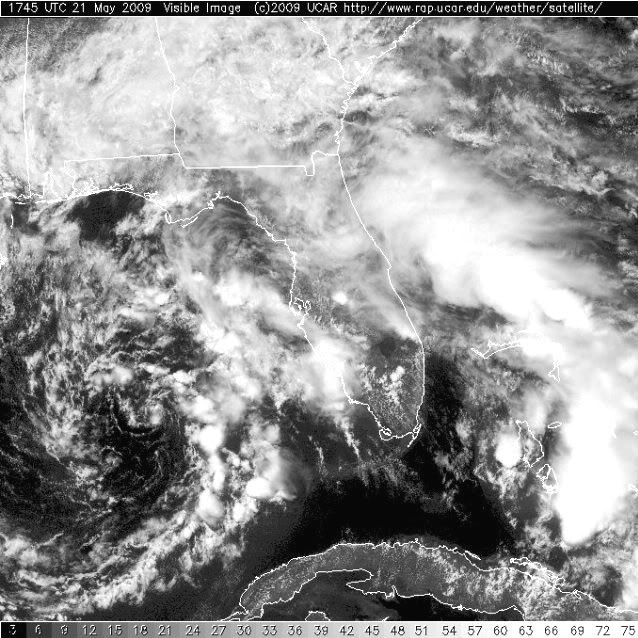
So what is this spin headed toward the FL. panhandle?
http://www.rap.ucar.edu/weather/satelli ... uration=12
http://www.rap.ucar.edu/weather/satelli ... uration=12
0 likes
Re: Low Pressure in Gulf of Mexico
Stormcenter wrote:So what is this spin headed toward the FL. panhandle?
http://www.rap.ucar.edu/weather/satelli ... uration=12
Is that the upper low?
0 likes
Who is online
Users browsing this forum: No registered users and 124 guests