
Moderator: S2k Moderators


GCANE wrote:Currently no model support, but going to be watching the W GoM around Thursday and Friday, this upcoming week.
The massive Rossby Wave will sweep down and setup an Anticyclone Rossby Wave Break in the GoM and develop a large Anticyclone over the weekend.
There should be some very strong LL convergence along the MX coast.
Need to watch how this may move out into the GoM.
Very moist troposphere then.
I can see a possible fast spin up that may effect the E-TX / LA Coast.
UL Ventilation would be very notable.
https://i.imgur.com/uB04F8P.png
https://i.imgur.com/5vprxTh.png
https://i.imgur.com/EQaIXOF.png
https://i.imgur.com/IwOYyct.png


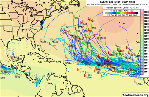
aspen wrote:There is one hell of a wave train that’ll be going on for the next 7-10+ days according to the GFS, Euro, CMC, and ICON.
Wave 1: Invest 91L, unlikely to develop but could interact with some of the other waves
Wave 2: Invest 92L, likely to develop within 2-4 days according to the models. This is probably future Paulette.
Wave 3: recently given a high chance of development, although most models recurve this quicker and don’t give it a ton of time to do anything.
Wave 4: expected to emerge into the east Atlantic on Thursday or Friday, and most models show significant development
Wave 5: expected to emerge into the Atlantic next weekend, will probably need to be watched for development.


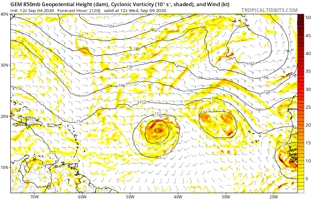
LarryWx wrote:gatorcane wrote:12Z CMC has it too. Animation below. Getting a little late to have something make the journey across to impact the CONUS especially that deep, but will need to watch the islands:
https://i.postimg.cc/Vkb1Dxgk/gem-z850-vort-eatl-fh120-240.gif
Gator is right to say that something becoming a TD in the E MDR ~9/10 (as the last two Euro and CMC runs have) is getting late to make it to the CONUS. However, it is according to climo/history still within the "higher risk" interval as per the following:
Here is a breakdown of the 51 1851-2020 (through 9/4/20) CV storms** that hit the CONUS based on dates of initial FORMATION of a TD+:
7/5, 7/11, 7/15, 7/31, 8/3, 8/3, 8/5, 8/7, 8/7, 8/15, 8/15, 8/16, 8/16, 8/17, 8/17, 8/18, 8/19, 8/19, 8/20, 8/20, 8/21, 8/21, 8/23, 8/24, 8/25, 8/25, 8/27, 8/28, 8/28, 8/29, 8/29, 8/29, 8/31, 9/1, 9/2, 9/3, 9/4, 9/6, 9/6, 9/7, 9/8, 9/9, 9/10, 9/10, 9/10, 9/11, 9/15, 9/16, 9/21, 9/21, 9/25
As you can see, Sept 9-11 has been just about as active for geneses of CONUS hitters as any other three day period with five of them. It is just after Sept 11 that the chances of an E MDR genesis later hitting the CONUS go way down.
Which 5 CV storms formed on Sept 9-11 and later hit the CONUS?
1. 9/11/1926: formed 15N, 46W; hit S FL at its peak, a cat 4 on 9/18
2. 9/9/1938: formed 13N, 19W; hit NY/NE 9/21 as a cat 3 after peaking at cat 5
3. 9/10/1955: Ione formed 14N, 41W ; hit NC 9/18 as a cat 2 after peaking as a cat 4
4. 9/10/1961: Esther formed 12N, 32W; hit NE 9/25 as a TS after peaking at 919 mb/cat 5
5. 9/10/1989: Hugo formed 13N, 20W; hit SC 9/22 as a cat 4 after peaking at cat 5
In addition, there were 3 geneses in the far E Atlantic (near 25W) a good bit later that later hit the CONUS:
- Formed 9/25/1893 and hit SC near its cat 3 peak
- Formed 9/16/1985 and hit NC/NY (Gloria) at cat 2/1 after peaking at cat 4
- Formed 9/15/1998 and hit FL/MS/AL (Georges) as a cat 2 after peaking at cat 4
**My def. of CV storm: TS/H that first became a TD+ E of 50W and S of 20N
Spacecoast wrote::uarrow:
How about this CV storm?
1893-10-13 (formed 09-25-1893) -SC -Cat 3 - 105 knots - unnamed


TheStormExpert wrote:00z EPS is showing nothing but fishes.
https://thumbs.gfycat.com/ScaredPlayfulAtlanticspadefish-size_restricted.gif
https://iili.io/29kxQp.md.png


Users browsing this forum: Iceresistance, MarioProtVI and 262 guests


