2020 Global Model Runs Discussion (Out thru day 16)

This is the general tropical discussion area. Anyone can take their shot at predicting a storms path.

Moderator: S2k Moderators

Forum rules

The posts in this forum are NOT official forecasts and should not be used as such. They are just the opinion of the poster and may or may not be backed by sound meteorological data. They are NOT endorsed by any professional institution or STORM2K. For official information, please refer to products from the National Hurricane Center and National Weather Service.

Help Support Storm2K
Message
Author
TheStormExpert

Re: 2020 Global Model Runs Discussion (Out thru day 16)

#2061 Postby TheStormExpert » Sat Sep 05, 2020 3:56 am

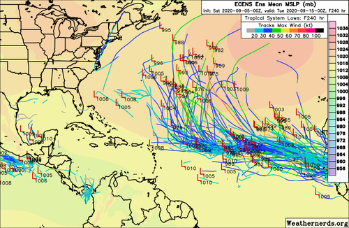
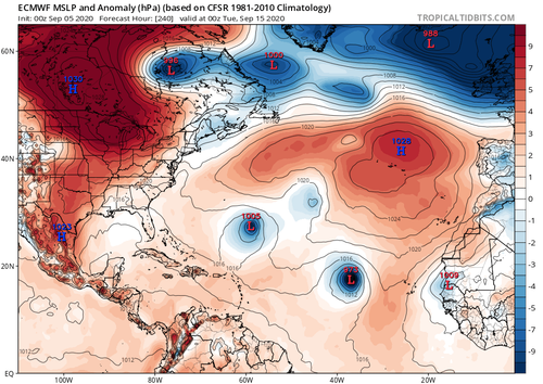
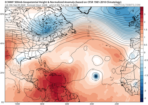
00z Euro smells awfully fishy through 10 days! No dangerous ridges in sight.
:fishing:

Image

Image
0 likes   

User avatar
Hammy
Category 5
Category 5
Posts: 5849
Age: 42
Joined: Fri May 25, 2012 5:25 pm
Contact:

Re: 2020 Global Model Runs Discussion (Out thru day 16)

#2062 Postby Hammy » Sat Sep 05, 2020 5:04 am

GFS now has three storms by Tuesday, all forming within 72 hours.

Image
0 likes   
The above post is not official and should not be used as such. It is the opinion of the poster and may or may not be backed by sound meteorological data. It is not endorsed by any professional institution or storm2k.org. For official information, please refer to the NHC and NWS products.

User avatar
GCANE
S2K Supporter
S2K Supporter
Posts: 11500
Joined: Mon Oct 22, 2007 8:03 am

Re: 2020 Global Model Runs Discussion (Out thru day 16)

#2063 Postby GCANE » Sat Sep 05, 2020 6:08 am

Currently no model support, but going to be watching the W GoM around Thursday and Friday, this upcoming week.
The massive Rossby Wave will sweep down and setup an Anticyclone Rossby Wave Break in the GoM and develop a large Anticyclone over the weekend.
There should be some very strong LL convergence along the MX coast.
Need to watch how this may move out into the GoM.
Very moist troposphere then.
I can see a possible fast spin up that may effect the E-TX / LA Coast.
UL Ventilation would be very notable.


Image

Image

Image

Image
2 likes   

TheStormExpert

Re: 2020 Global Model Runs Discussion (Out thru day 16)

#2064 Postby TheStormExpert » Sat Sep 05, 2020 7:25 am

00z EPS is showing nothing but fishes.

Image

Image
1 likes   

User avatar
GCANE
S2K Supporter
S2K Supporter
Posts: 11500
Joined: Mon Oct 22, 2007 8:03 am

Re: 2020 Global Model Runs Discussion (Out thru day 16)

#2065 Postby GCANE » Sat Sep 05, 2020 7:53 am

GCANE wrote:Currently no model support, but going to be watching the W GoM around Thursday and Friday, this upcoming week.
The massive Rossby Wave will sweep down and setup an Anticyclone Rossby Wave Break in the GoM and develop a large Anticyclone over the weekend.
There should be some very strong LL convergence along the MX coast.
Need to watch how this may move out into the GoM.
Very moist troposphere then.
I can see a possible fast spin up that may effect the E-TX / LA Coast.
UL Ventilation would be very notable.


https://i.imgur.com/uB04F8P.png

https://i.imgur.com/5vprxTh.png

https://i.imgur.com/EQaIXOF.png

https://i.imgur.com/IwOYyct.png


ICON is spinning up more east than what I am figuring, along the W FL coast.
It all depends how the Rossby Wave evolves.
Could be the whole N GoM maybe in play in about 6 days.

Image
0 likes   

User avatar
aspen
Category 5
Category 5
Posts: 8818
Joined: Sat Oct 12, 2019 7:10 pm
Location: Connecticut, USA

Re: 2020 Global Model Runs Discussion (Out thru day 16)

#2066 Postby aspen » Sat Sep 05, 2020 7:58 am

There is one hell of a wave train that’ll be going on for the next 7-10+ days according to the GFS, Euro, CMC, and ICON.

Wave 1: Invest 91L, unlikely to develop but could interact with some of the other waves

Wave 2: Invest 92L, likely to develop within 2-4 days according to the models. This is probably future Paulette.

Wave 3: recently given a high chance of development, although most models recurve this quicker and don’t give it a ton of time to do anything.

Wave 4: expected to emerge into the east Atlantic on Thursday or Friday, and most models show significant development

Wave 5: expected to emerge into the Atlantic next weekend, will probably need to be watched for development.
2 likes   
Irene '11 Sandy '12 Hermine '16 5/15/2018 Derecho Fay '20 Isaias '20 Elsa '21 Henri '21 Ida '21

I am only a meteorology enthusiast who knows a decent amount about tropical cyclones. Look to the professional mets, the NHC, or your local weather office for the best information.

User avatar
DorkyMcDorkface
Category 3
Category 3
Posts: 890
Age: 27
Joined: Mon Sep 30, 2019 1:32 pm
Location: Mid-Atlantic

Re: 2020 Global Model Runs Discussion (Out thru day 16)

#2067 Postby DorkyMcDorkface » Sat Sep 05, 2020 9:14 am

Dunno where exactly to post this but I guess this thread is relatively appropriate.

 https://twitter.com/Weathernerds/status/1302244479945052160


4 likes   
Please note the thougths expressed by this account are solely those of the user and are from a hobbyist perspective. For more comprehensive analysis, consult an actual professional meteorologist or meteorology agency.


Floyd 1999 | Isabel 2003 | Hanna 2008 | Irene 2011 | Sandy 2012 | Isaias 2020

User avatar
Spacecoast
Category 2
Category 2
Posts: 758
Joined: Thu Aug 31, 2017 2:03 pm

Re: 2020 Global Model Runs Discussion (Out thru day 16)

#2068 Postby Spacecoast » Sat Sep 05, 2020 9:50 am

aspen wrote:There is one hell of a wave train that’ll be going on for the next 7-10+ days according to the GFS, Euro, CMC, and ICON.

Wave 1: Invest 91L, unlikely to develop but could interact with some of the other waves

Wave 2: Invest 92L, likely to develop within 2-4 days according to the models. This is probably future Paulette.

Wave 3: recently given a high chance of development, although most models recurve this quicker and don’t give it a ton of time to do anything.

Wave 4: expected to emerge into the east Atlantic on Thursday or Friday, and most models show significant development

Wave 5: expected to emerge into the Atlantic next weekend, will probably need to be watched for development.

09/05 06z GEFS ensemble genesis probabilities show Wave 1, Wave 2, and Wave 3, and 9% prob for Wave 4:
Image

ECMF 00Z ENS shows only Wave 2, and Wave 3, with very high probability (>90%) in next 24 hrs:
Image
1 likes   

User avatar
SFLcane
S2K Supporter
S2K Supporter
Posts: 10163
Age: 47
Joined: Sat Jun 05, 2010 1:44 pm
Location: Lake Worth Florida

Re: 2020 Global Model Runs Discussion (Out thru day 16)

#2069 Postby SFLcane » Sat Sep 05, 2020 10:12 am

Overnight icon offered this...

Image
0 likes   

User avatar
Hypercane_Kyle
Category 5
Category 5
Posts: 3354
Joined: Sat Mar 07, 2015 7:58 pm
Location: Cape Canaveral, FL

Re: 2020 Global Model Runs Discussion (Out thru day 16)

#2070 Postby Hypercane_Kyle » Sat Sep 05, 2020 10:31 am

06z GFS-Para showing three powerful hurricanes trekking across the Atlantic.
1 likes   
My posts are my own personal opinion, defer to the National Hurricane Center (NHC) and other NOAA products for decision making during hurricane season.

shiny-pebble
Category 1
Category 1
Posts: 299
Joined: Thu Jul 05, 2018 1:38 pm

Re: 2020 Global Model Runs Discussion (Out thru day 16)

#2071 Postby shiny-pebble » Sat Sep 05, 2020 10:46 am

If the GFS-Para were to verify the Atlantic would rack up some crazy ACE in a short period of time. Two are fishes but one effects Bermuda.

Sent from my SM-G970U using Tapatalk
0 likes   
Not an meteorologist! Just someone who is interested in weather. Please refer to the NHC and local weather officials to make decisions.
-Jack 8-)

Shell Mound
Category 5
Category 5
Posts: 2434
Age: 32
Joined: Thu Sep 07, 2017 3:39 pm
Location: St. Petersburg, FL → Scandinavia

Re: 2020 Global Model Runs Discussion (Out thru day 16)

#2072 Postby Shell Mound » Sat Sep 05, 2020 11:03 am

LarryWx wrote:
gatorcane wrote:12Z CMC has it too. Animation below. Getting a little late to have something make the journey across to impact the CONUS especially that deep, but will need to watch the islands:

https://i.postimg.cc/Vkb1Dxgk/gem-z850-vort-eatl-fh120-240.gif


Gator is right to say that something becoming a TD in the E MDR ~9/10 (as the last two Euro and CMC runs have) is getting late to make it to the CONUS. However, it is according to climo/history still within the "higher risk" interval as per the following:

Here is a breakdown of the 51 1851-2020 (through 9/4/20) CV storms** that hit the CONUS based on dates of initial FORMATION of a TD+:

7/5, 7/11, 7/15, 7/31, 8/3, 8/3, 8/5, 8/7, 8/7, 8/15, 8/15, 8/16, 8/16, 8/17, 8/17, 8/18, 8/19, 8/19, 8/20, 8/20, 8/21, 8/21, 8/23, 8/24, 8/25, 8/25, 8/27, 8/28, 8/28, 8/29, 8/29, 8/29, 8/31, 9/1, 9/2, 9/3, 9/4, 9/6, 9/6, 9/7, 9/8, 9/9, 9/10, 9/10, 9/10, 9/11, 9/15, 9/16, 9/21, 9/21, 9/25

As you can see, Sept 9-11 has been just about as active for geneses of CONUS hitters as any other three day period with five of them. It is just after Sept 11 that the chances of an E MDR genesis later hitting the CONUS go way down.

Which 5 CV storms formed on Sept 9-11 and later hit the CONUS?

1. 9/11/1926: formed 15N, 46W; hit S FL at its peak, a cat 4 on 9/18
2. 9/9/1938: formed 13N, 19W; hit NY/NE 9/21 as a cat 3 after peaking at cat 5
3. 9/10/1955: Ione formed 14N, 41W ; hit NC 9/18 as a cat 2 after peaking as a cat 4
4. 9/10/1961: Esther formed 12N, 32W; hit NE 9/25 as a TS after peaking at 919 mb/cat 5
5. 9/10/1989: Hugo formed 13N, 20W; hit SC 9/22 as a cat 4 after peaking at cat 5


In addition, there were 3 geneses in the far E Atlantic (near 25W) a good bit later that later hit the CONUS:

- Formed 9/25/1893 and hit SC near its cat 3 peak
- Formed 9/16/1985 and hit NC/NY (Gloria) at cat 2/1 after peaking at cat 4
- Formed 9/15/1998 and hit FL/MS/AL (Georges) as a cat 2 after peaking at cat 4

**My def. of CV storm: TS/H that first became a TD+ E of 50W and S of 20N

:uarrow: I would highly recommend that people read Larry’s statistics as posted above.

Here are the dates (month/day), from earliest to latest, of all (30) individual Cat-4+ landfalls on the mainland U.S. from 1851–present:

8/10, 8/13, 8/14, 8/17, 8/18, 8/18, 8/20, 8/24, 8/25, 8/26, 8/27, 9/3, 9/8, 9/9, 9/10, 9/10, 9/10, 9/11, 9/15, 9/16, 9/17, 9/18, 9/22, 9/22, 9/29, 10/2, 10/2, 10/10, 10/14, 10/18

As to the formative (TD or stronger) dates of these storms, here they are—note that each is arranged in chronological order and does not necessarily correspond to its partner in the column above:

8/5, 8/9, 8/9, 8/12, 8/12, 8/12, 8/14, 8/16, 8/16, 8/20, 8/23, 8/27, 8/27, 8/29, 8/29, 8/30, 9/2, 9/3, 9/4, 9/6, 9/10, 9/11, 9/12, 9/18, 9/20, 9/25, 9/27, 10/5, 10/6, 10/13

Here is a listing of the storms by YYYY, MM, and DD, with the date of landfall listed first, then the date of formation (TD or stronger) in parentheses:

  • 1856–08–10 (formed: 1856–08–09) — LA — Cat 4 — 130 knots — “Last Island”
  • 2004–08–13 (formed: 2004–08–09) — FL — Cat 4 — 130 knots — Charley
  • 1932–08–14 (formed: 1932–08–12) — TX — Cat 4 — 130 knots — “Freeport”
  • 1915–08–17 (formed: 1915–08–05) — TX — Cat 4 — 115 knots — “Galveston II”
  • 1916–08–18 (formed: 1916–08–12) — TX — Cat 4 — 115 knots — “Texas” (Kingsville / Baffin Bay)
  • 1969–08–18 (formed: 1969–08–14) — MS — Cat 5 — 150 knots — Camille
  • 1886–08–20 (formed: 1886–08–12) — TX — Cat 4 — 130 knots — “Indianola II”*
  • 1992–08–24 (formed: 1992–08–16) — FL — Cat 5 — 145 knots — Andrew
  • 2017–08–25 (formed: 2017–08–16) — TX — Cat 4 — 115 knots — Harvey
  • 1949–08–26 (formed: 1949–08–23) — FL — Cat 4 — 115 knots — “Florida” (Lake Worth)
  • 2020–08–27 (formed: 2020–08–20) — LA — Cat 4 — 130 knots — Laura
  • 1935–09–03 (formed: 1935–08–29) — FL — Cat 5 — 160 knots — “Labor Day” (Craig Key)
  • 1965–09–08 (formed: 1965–08–27) — LA — Cat 4 — 115 knots — Betsy
  • 1900–09–09 (formed: 1900–08–27) — TX — Cat 4 — 120 knots — “Galveston I”
  • 1919–09–10 (formed: 1919–09–02) — FL — Cat 4 — 130 knots — “Florida Keys”
  • 1960–09–10 (formed: 1960–08–29) — FL — Cat 4 — 125 knots — Donna
  • 2017–09–10 (formed: 2017–08–30) — FL — Cat 4 — 115 knots — Irma
  • 1961–09–11 (formed: 1961–09–03) — TX — Cat 4 — 125 knots — Carla
  • 1945–09–15 (formed: 1945–09–12) — FL — Cat 4 — 115 knots — “Homestead”
  • 1947–09–16 (formed: 1947–09–04) — FL — Cat 4 — 115 knots — “Fort Lauderdale”
  • 1928–09–17 (formed: 1928–09–06) — FL — Cat 4 — 125 knots — “San Felipe II / Lake Okeechobee” (Palm Beach)
  • 1926–09–18 (formed: 1926–09–11) — FL — Cat 4 — 125 knots — “Great Miami”
  • 1948–09–22 (formed: 1948–09–18) — FL — Cat 4 — 115 knots — “Florida” (Chokoloskee)
  • 1989–09–22 (formed: 1989–09–10) — SC — Cat 4 — 120 knots — Hugo
  • 1959–09–29 (formed: 1959–09–20) — SC — Cat 4 — 115 knots — Gracie
  • 1893–10–02 (formed: 1893–09–27) — LA — Cat 4 — 115 knots — “Chenière Caminada”
  • 1898–10–02 (formed: 1898–09–25) — GA — Cat 4 — 115 knots — “Georgia” (Brunswick)
  • 2018–10–10 (formed: 2018–10–06) — FL — Cat 5 — 140 knots — Michael
  • 1954–10–14 (formed: 1954–10–05) — SC — Cat 4 — 115 knots — Hazel
  • 1950–10–18 (formed: 1950–10–13) — FL — Cat 4 — 115 knots — King
Bold: met Larry’s definition of a CV storm
*First major Indianola hurricane occurred in 1875 and made landfall as a 100-knot Cat-3 in the same area

Out of these 30 cases, the earliest Cat-4+ LF occurred on 8/10 (“Last Island,” LA, 1856) and the latest on 10/18 (King, FL, 1950). Of all the cases, only 37% or a little more than a third were CV-type systems. 63% or roughly two-thirds of all the cases formed on or before September 5. Taken together, all these data indicate that, based on climatology, most Cat-4+ landfalls on the mainland U.S. originate from homegrown systems that usually form on or before September 5. In 2020 thus far we have already seen one long-tracking, CV-type, Cat-4+ landfall: Laura in LA, a high-end Cat-4 at that. Only 2017 featured two or more Cat-4+ landfalls on the mainland U.S., both of which were CV-type systems, which makes the occurrence even more impressive. Since we’ve already seen Laura, no one should be surprised if we see no additional major, much less Cat-4+, impacts to the mainland U.S. for the rest of 2020, even if we end up with a very active season. Currently, modelled indicators suggest that if the U.S. were to witness one more major, let alone Cat-4+, impact, it would likely be a homegrown system in the western Caribbean or Gulf during late September or October, much like Michael (2018), Hazel (1954), King (1950), or the 1948 Florida hurricane. Bear in mind that, besides Laura, the mainland U.S. has already seen three other Cat-4+ impacts since 2017: Harvey, Irma, and Michael.
10 likes   
CVW / MiamiensisWx / Shell Mound
The posts in this forum are NOT official forecasts and should not be used as such. They are just the opinion of the poster and may or may not be backed by sound meteorological data. They are NOT endorsed by any professional institution or STORM2K. For official information, please refer to products from the NHC and NWS.

User avatar
Spacecoast
Category 2
Category 2
Posts: 758
Joined: Thu Aug 31, 2017 2:03 pm

Re: 2020 Global Model Runs Discussion (Out thru day 16)

#2073 Postby Spacecoast » Sat Sep 05, 2020 11:35 am

:uarrow:
How about this CV storm?
1893-10-13 (formed 09-25-1893) -SC -Cat 3 - 105 knots - unnamed
* edit neverming, LarryWx listed it above
Last edited by Spacecoast on Sat Sep 05, 2020 11:40 am, edited 1 time in total.
1 likes   

Shell Mound
Category 5
Category 5
Posts: 2434
Age: 32
Joined: Thu Sep 07, 2017 3:39 pm
Location: St. Petersburg, FL → Scandinavia

Re: 2020 Global Model Runs Discussion (Out thru day 16)

#2074 Postby Shell Mound » Sat Sep 05, 2020 11:39 am

Spacecoast wrote::uarrow:
How about this CV storm?
1893-10-13 (formed 09-25-1893) -SC -Cat 3 - 105 knots - unnamed

I only listed Cat-4+ impacts.
0 likes   
CVW / MiamiensisWx / Shell Mound
The posts in this forum are NOT official forecasts and should not be used as such. They are just the opinion of the poster and may or may not be backed by sound meteorological data. They are NOT endorsed by any professional institution or STORM2K. For official information, please refer to products from the NHC and NWS.

User avatar
cycloneye
Admin
Admin
Posts: 145480
Age: 68
Joined: Thu Oct 10, 2002 10:54 am
Location: San Juan, Puerto Rico

Re: 2020 Global Model Runs Discussion (Out thru day 16)

#2075 Postby cycloneye » Sat Sep 05, 2020 12:13 pm

I moved the posts of what GFS has to the wave that emerges on Sunday thread.

viewtopic.php?f=31&t=121286&p=2850321#p2850321
1 likes   
Visit the Caribbean-Central America Weather Thread where you can find at first post web cams,radars
and observations from Caribbean basin members Click Here

User avatar
chaser1
S2K Supporter
S2K Supporter
Posts: 5476
Age: 64
Joined: Sat Oct 15, 2005 5:59 pm
Location: Longwood, Fl

Re: 2020 Global Model Runs Discussion (Out thru day 16)

#2076 Postby chaser1 » Sat Sep 05, 2020 12:13 pm

SFLcane, yeah I think so?? Looks like your post, Larry's post, and mine regarding the latest 12Z GFS long long range forecast all got deleted but not sure why. Certainly wasn't any kind of flame war going on.... odd.
1 likes   
Andy D

(For official information, please refer to the NHC and NWS products.)

User avatar
aspen
Category 5
Category 5
Posts: 8818
Joined: Sat Oct 12, 2019 7:10 pm
Location: Connecticut, USA

Re: 2020 Global Model Runs Discussion (Out thru day 16)

#2077 Postby aspen » Sat Sep 05, 2020 12:17 pm


Lots of phish and lots of ACE. That first system looks like it’ll be going through the large area of unusually warm mid-latitude waters around and east of Bermuda, where it could become a major given other favorable environmental conditions.
0 likes   
Irene '11 Sandy '12 Hermine '16 5/15/2018 Derecho Fay '20 Isaias '20 Elsa '21 Henri '21 Ida '21

I am only a meteorology enthusiast who knows a decent amount about tropical cyclones. Look to the professional mets, the NHC, or your local weather office for the best information.

User avatar
drezee
S2K Supporter
S2K Supporter
Posts: 3664
Joined: Mon Jun 09, 2003 12:49 pm
Location: FL

Re: 2020 Global Model Runs Discussion (Out thru day 16)

#2078 Postby drezee » Sat Sep 05, 2020 1:32 pm

1 likes   

User avatar
northjaxpro
S2K Supporter
S2K Supporter
Posts: 8900
Joined: Mon Sep 27, 2010 11:21 am
Location: Jacksonville, FL

Re: 2020 Global Model Runs Discussion (Out thru day 16)

#2079 Postby northjaxpro » Sat Sep 05, 2020 1:40 pm


Ahh, I was just about to post about this myself. Actually, I am.

Just a reminder of the latest Teleconnection forecast. A very strong +NAO looks to continue right on through Sept19 and possibly longer. The EPS Ensembles look potentially very worrisome down the road. It corresponds to the teleconnections forecast if it verifies...

Image
3 likes   
NEVER, EVER SAY NEVER in the tropics and weather in general, and most importantly, with life itself!!

________________________________________________________________________________________

Fay 2008 Beryl 2012 Debby 2012 Colin 2016 Hermine 2016 Julia 2016 Matthew 2016 Irma 2017 Dorian 2019

User avatar
SFLcane
S2K Supporter
S2K Supporter
Posts: 10163
Age: 47
Joined: Sat Jun 05, 2010 1:44 pm
Location: Lake Worth Florida

Re: 2020 Global Model Runs Discussion (Out thru day 16)

#2080 Postby SFLcane » Sat Sep 05, 2020 1:51 pm

0 likes   


Return to “Talkin' Tropics”

Who is online

Users browsing this forum: Lizzytiz1, Sps123 and 28 guests