2018 EPAC Season
Moderator: S2k Moderators
Forum rules
The posts in this forum are NOT official forecasts and should not be used as such. They are just the opinion of the poster and may or may not be backed by sound meteorological data. They are NOT endorsed by any professional institution or STORM2K. For official information, please refer to products from the National Hurricane Center and National Weather Service.
- Yellow Evan
- Professional-Met
- Posts: 15960
- Age: 25
- Joined: Fri Jul 15, 2011 12:48 pm
- Location: Henderson, Nevada/Honolulu, HI
- Contact:
Re: 2018 EPAC Season
18z FV3. Has the two interacting off the MX coast for a bit in the long range.
0 likes
- cycloneye
- Admin
- Posts: 139593
- Age: 67
- Joined: Thu Oct 10, 2002 10:54 am
- Location: San Juan, Puerto Rico
Re: 2018 EPAC Season
Tropical Weather Outlook
NWS National Hurricane Center Miami FL
1100 PM PDT Sat Jun 2 2018
For the eastern North Pacific...east of 140 degrees west longitude:
1. A large area of disorganized cloudiness and showers is centered a
few hundred miles south of the southern coast of Mexico.
Environmental conditions are forecast to support development of this
system over the next several days, and a tropical depression is
likely to form on Wednesday or Thursday while it moves slowly
west-northwestward.
* Formation chance through 48 hours...low...20 percent.
* Formation chance through 5 days...high...80 percent.
Forecaster Blake
0 likes
Visit the Caribbean-Central America Weather Thread where you can find at first post web cams,radars
and observations from Caribbean basin members Click Here
- cycloneye
- Admin
- Posts: 139593
- Age: 67
- Joined: Thu Oct 10, 2002 10:54 am
- Location: San Juan, Puerto Rico
Re: 2018 EPAC Season
20%-90%
Tropical Weather Outlook
NWS National Hurricane Center Miami FL
500 AM PDT Sun Jun 3 2018
For the eastern North Pacific...east of 140 degrees west longitude:
A large area of disorganized showers and thunderstorms is centered
a few hundred miles south of the southern coast of Mexico.
Environmental conditions are forecast to support development of this
system during the next several days, and a tropical depression is
expected to form on Wednesday or Thursday while it moves slowly
west-northwestward.
* Formation chance through 48 hours...low...20 percent.
* Formation chance through 5 days...high...90 percent.
$$
Forecaster Cangialosi
0 likes
Visit the Caribbean-Central America Weather Thread where you can find at first post web cams,radars
and observations from Caribbean basin members Click Here
- cycloneye
- Admin
- Posts: 139593
- Age: 67
- Joined: Thu Oct 10, 2002 10:54 am
- Location: San Juan, Puerto Rico
Re: 2018 EPAC Season
12z GFS has a Cat 3 for the 9th
1 likes
Visit the Caribbean-Central America Weather Thread where you can find at first post web cams,radars
and observations from Caribbean basin members Click Here
- cycloneye
- Admin
- Posts: 139593
- Age: 67
- Joined: Thu Oct 10, 2002 10:54 am
- Location: San Juan, Puerto Rico
Re: 2018 EPAC Season
Tropical Weather Outlook
NWS National Hurricane Center Miami FL
1100 AM PDT Sun Jun 3 2018
For the eastern North Pacific...east of 140 degrees west longitude:
Disorganized showers and thunderstorms continue in association with
a trough of low pressure located a few hundred miles south of
the southern coast of Mexico. Environmental conditions are forecast
to support development of this system, and a tropical depression is
expected to form on Wednesday or Thursday while it moves slowly
west-northwestward.
* Formation chance through 48 hours...low...30 percent.
* Formation chance through 5 days...high...90 percent.
$$
Forecaster Cangialosi
0 likes
Visit the Caribbean-Central America Weather Thread where you can find at first post web cams,radars
and observations from Caribbean basin members Click Here
- AnnularCane
- S2K Supporter
- Posts: 2656
- Joined: Thu Jun 08, 2006 9:18 am
- Location: Wytheville, VA
-
- Category 5
- Posts: 2904
- Joined: Sat Jul 28, 2012 6:19 pm
- Location: Trinidad and Tobago
Re: 2018 EPAC Season: 11 AM PDT TWO=30%-90%
I've noticed that EPAC systems usually take a bit longer to get their invest title.
0 likes
PLEASE NOTE: With the exception of information from weather agencies that I may copy and paste here, my posts will NEVER be official, since I am NOT a meteorologist. They are solely my amateur opinion, and may or may not be accurate. Therefore, please DO NOT use them as official details, particularly when making important decisions. Thank you.
- Yellow Evan
- Professional-Met
- Posts: 15960
- Age: 25
- Joined: Fri Jul 15, 2011 12:48 pm
- Location: Henderson, Nevada/Honolulu, HI
- Contact:
Re: 2018 EPAC Season: 11 AM PDT TWO=30%-90%
hurricanes1234 wrote:I've noticed that EPAC systems usually take a bit longer to get their invest title.
Well EPAC storms are generally have less for a lack of a better term complexity in their forecasts so less of an urge for the NHC to seek the data they get when they call something an invest
1 likes
Re: 2018 EPAC Season: 11 AM PDT TWO=30%-90%
Interesting of how the Euro is not aggressive at all for development over the next 72 hours while the GFS is.
0 likes
- cycloneye
- Admin
- Posts: 139593
- Age: 67
- Joined: Thu Oct 10, 2002 10:54 am
- Location: San Juan, Puerto Rico
Re: 2018 EPAC Season: 11 AM PDT TWO=30%-90%
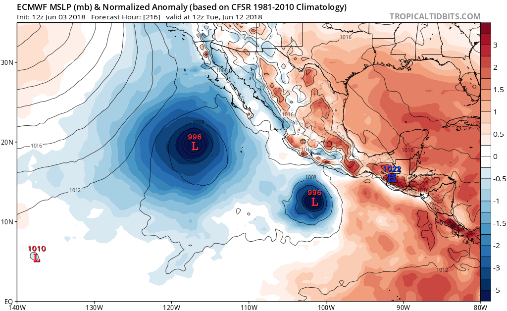
NDG wrote:Interesting of how the Euro is not aggressive at all for development over the next 72 hours while the GFS is.
Overall,Euro is weaker than GFS on the first one but are the same developing the second system.
0 likes
Visit the Caribbean-Central America Weather Thread where you can find at first post web cams,radars
and observations from Caribbean basin members Click Here
- cycloneye
- Admin
- Posts: 139593
- Age: 67
- Joined: Thu Oct 10, 2002 10:54 am
- Location: San Juan, Puerto Rico
Re: 2018 EPAC Season
For the second system is the opposite NDG as Euro is a little more stronger than GFS and on the track are different. Same timeframe at 240 hours.
GFS
Euro
GFS
Euro
1 likes
Visit the Caribbean-Central America Weather Thread where you can find at first post web cams,radars
and observations from Caribbean basin members Click Here
- Yellow Evan
- Professional-Met
- Posts: 15960
- Age: 25
- Joined: Fri Jul 15, 2011 12:48 pm
- Location: Henderson, Nevada/Honolulu, HI
- Contact:
Re: 2018 EPAC Season
Major difference in setup in day 5
ECMWF has more of a ridge extending more south leading to a shorter window of favorable conditions.
GFS has this moving NW right into Soccoro Island on a parallel track
FV3 is the most reasonable through day 5 but long-term not so much as it has an interaction with the second system.
ECMWF has more of a ridge extending more south leading to a shorter window of favorable conditions.
GFS has this moving NW right into Soccoro Island on a parallel track
FV3 is the most reasonable through day 5 but long-term not so much as it has an interaction with the second system.
0 likes
- cycloneye
- Admin
- Posts: 139593
- Age: 67
- Joined: Thu Oct 10, 2002 10:54 am
- Location: San Juan, Puerto Rico
Re: 2018 EPAC Season: 11 AM PDT TWO=30%-90%
AnnularCane wrote:Still no invest?
Is imminent that Invest 91E will be up in a few hours.The only thing holding them to put it up may be where a low pressure forms but I guess they have been tracking on best track in a not public version.
0 likes
Visit the Caribbean-Central America Weather Thread where you can find at first post web cams,radars
and observations from Caribbean basin members Click Here
- cycloneye
- Admin
- Posts: 139593
- Age: 67
- Joined: Thu Oct 10, 2002 10:54 am
- Location: San Juan, Puerto Rico
Re: 2018 EPAC Season
Near 9N-100W?
1 likes
Visit the Caribbean-Central America Weather Thread where you can find at first post web cams,radars
and observations from Caribbean basin members Click Here
- cycloneye
- Admin
- Posts: 139593
- Age: 67
- Joined: Thu Oct 10, 2002 10:54 am
- Location: San Juan, Puerto Rico
Re: 2018 EPAC Season
0 likes
Visit the Caribbean-Central America Weather Thread where you can find at first post web cams,radars
and observations from Caribbean basin members Click Here
- Kingarabian
- S2K Supporter
- Posts: 15461
- Joined: Sat Aug 08, 2009 3:06 am
- Location: Honolulu, Hawaii
Re: 2018 EPAC Season
cycloneye wrote:Near 9N-100W?
[img]http://rammb.cira.colostate.edu/ramsdis/online/images/latest/tropical/tropical_ge_4km_visir2_floater_1.gif[img]
Should be tagged anytime now. Looks good on satellite to warrant 50% development chances in the next 48 hours IMO.
1 likes
RIP Kobe Bryant
- Kingarabian
- S2K Supporter
- Posts: 15461
- Joined: Sat Aug 08, 2009 3:06 am
- Location: Honolulu, Hawaii
Re: 2018 EPAC Season
Large disturbance. Both the Euro and the GFS solutions make sense. It could take a bit more time to develop due to its size, but because of improving conditions and good structure, it could also take off within the next 48 hours.
0 likes
RIP Kobe Bryant
- cycloneye
- Admin
- Posts: 139593
- Age: 67
- Joined: Thu Oct 10, 2002 10:54 am
- Location: San Juan, Puerto Rico
Re: 2018 EPAC Season
cycloneye wrote:Near 9N-100W?
Are we looking to the right at the second system?
0 likes
Visit the Caribbean-Central America Weather Thread where you can find at first post web cams,radars
and observations from Caribbean basin members Click Here
- cycloneye
- Admin
- Posts: 139593
- Age: 67
- Joined: Thu Oct 10, 2002 10:54 am
- Location: San Juan, Puerto Rico
Re: 2018 EPAC Season
Yikes.943 mbs.
1 likes
Visit the Caribbean-Central America Weather Thread where you can find at first post web cams,radars
and observations from Caribbean basin members Click Here
Who is online
Users browsing this forum: Christiana, Cpv17, Google Adsense [Bot], Landy, TexasF6 and 62 guests