Possible Development Near the GA/Bahamas (Is Invest 98L)

This is the general tropical discussion area. Anyone can take their shot at predicting a storms path.

Moderator: S2k Moderators

Forum rules

The posts in this forum are NOT official forecasts and should not be used as such. They are just the opinion of the poster and may or may not be backed by sound meteorological data. They are NOT endorsed by any professional institution or STORM2K. For official information, please refer to products from the National Hurricane Center and National Weather Service.

Help Support Storm2K
Message
Author
User avatar
cycloneye
Admin
Admin
Posts: 139344
Age: 67
Joined: Thu Oct 10, 2002 10:54 am
Location: San Juan, Puerto Rico

Re: Possible Development Near the GA/Bahamas Early Next Week (40/70)

#241 Postby cycloneye » Sat Nov 05, 2022 4:23 pm

gatorcane wrote:ICON coming in a bit stronger, approaching Florida east coast at 993MB as opposed to 1001MB on the 12Z (108 hours).


Yes indeed.

Image
0 likes   
Visit the Caribbean-Central America Weather Thread where you can find at first post web cams,radars
and observations from Caribbean basin members Click Here

User avatar
Blown Away
S2K Supporter
S2K Supporter
Posts: 9867
Joined: Wed May 26, 2004 6:17 am

Re: Possible Development Near the GA/Bahamas Early Next Week (40/70)

#242 Postby Blown Away » Sat Nov 05, 2022 4:25 pm

Image

18z ICON… Farther W and much stronger Cat 1/2 into Melbourne.
Last edited by Blown Away on Sat Nov 05, 2022 4:26 pm, edited 1 time in total.
1 likes   
Hurricane Eye Experience: David 79, Irene 99, Frances 04, Jeanne 04, Wilma 05... EYE COMING MY WAY IN 2024…
Hurricane Brush Experience: Andrew 92, Erin 95, Floyd 99, Matthew 16, Irma 17, Ian 22, Nicole 22…

cane5
Tropical Storm
Tropical Storm
Posts: 249
Joined: Fri Jul 02, 2021 4:24 pm

Re: Possible Development Near the GA/Bahamas Early Next Week (40/70)

#243 Postby cane5 » Sat Nov 05, 2022 4:26 pm

GCANE wrote:
cane5 wrote:Can someone please give update on the ICON MODEL ???


Makes a landfall around JAX.
Kinda hard to believe due to the strong Rossby Wave in the vicinity then.
GFS is good at forecasting UL synoptic patterns.
I am going with the S FL landfall as advertised by GFS.

Thank you but the ICON seems to make the call early and end up right. Being in South Florida I’m even a bigger fan of ICON.
1 likes   

User avatar
toad strangler
S2K Supporter
S2K Supporter
Posts: 4172
Joined: Sun Jul 28, 2013 3:09 pm
Location: Earth
Contact:

Re: RE: Re: RE: Re: Possible Development Near the GA/Bahamas Early Next Week (40/70)

#244 Postby toad strangler » Sat Nov 05, 2022 4:27 pm

jlauderdal wrote:
AutoPenalti wrote:
jlauderdal wrote:He was rather bearish yesterday.

When isn’t he bearish

I can agree with his forecast, light breeze for south florida, a complete non-event for everybody in the east coast. If he doesn’t trust the GFS in any run, then I would agree with him.
I was bearish yesterday, today im mid range ts


I’m not sure if a warm core true TC would be worse than a subtropical gale. The latter in this case may have far greater implications for a huge swath of FL and SE CONUS coast. Precip & winds.
0 likes   

User avatar
AtlanticWind
S2K Supporter
S2K Supporter
Posts: 1805
Age: 65
Joined: Sun Aug 08, 2004 9:57 pm
Location: Plantation,Fla

Re: Possible Development Near the GA/Bahamas Early Next Week (40/70)

#245 Postby AtlanticWind » Sat Nov 05, 2022 4:30 pm

cane5 wrote:
GCANE wrote:
cane5 wrote:Can someone please give update on the ICON MODEL ???


Makes a landfall around JAX.
Kinda hard to believe due to the strong Rossby Wave in the vicinity then.
GFS is good at forecasting UL synoptic patterns.
I am going with the S FL landfall as advertised by GFS.

Thank you but the ICON seems to make the call early and end up right. Being in South Florida I’m even a bigger fan of ICON.

The trend in all the models today has been further south , I will trust GFS/Euro
over Icon everytime , I dont believe the Icon is even used for NHC consensus models.
0 likes   

BobHarlem
Category 5
Category 5
Posts: 1665
Joined: Thu Oct 20, 2005 6:11 pm

Re: RE: Re: RE: Re: Possible Development Near the GA/Bahamas Early Next Week (40/70)

#246 Postby BobHarlem » Sat Nov 05, 2022 4:35 pm

This thing is already overachieving with what it's bringing to Puerto Rico right now (more flooding), not liking these trends.
1 likes   

TheHurricaneGod
Tropical Storm
Tropical Storm
Posts: 146
Age: 21
Joined: Thu Apr 16, 2020 6:19 pm
Location: Fort Lauderdale

Re: Possible Development Near the GA/Bahamas Early Next Week (40/70)

#247 Postby TheHurricaneGod » Sat Nov 05, 2022 4:48 pm

Well well look what we have here. Haven't paid attention to the tropics for a while until today. When did the models start showing this potential storm?
0 likes   

User avatar
cycloneye
Admin
Admin
Posts: 139344
Age: 67
Joined: Thu Oct 10, 2002 10:54 am
Location: San Juan, Puerto Rico

Re: Possible Development Near the GA/Bahamas Early Next Week (40/70)

#248 Postby cycloneye » Sat Nov 05, 2022 4:48 pm

Flooding is occuring in many places and also some mudslides. Preliminary estimates so far are between 8-10 inches in parts of south and SE part of the island.

Image
1 likes   
Visit the Caribbean-Central America Weather Thread where you can find at first post web cams,radars
and observations from Caribbean basin members Click Here

User avatar
Jr0d
S2K Supporter
S2K Supporter
Posts: 1176
Joined: Tue Aug 27, 2019 10:52 am
Location: Cayo Hueso

Re: Possible Development Near the GA/Bahamas Early Next Week (40/70)

#249 Postby Jr0d » Sat Nov 05, 2022 4:49 pm

This is getting interesting. There was the Yankee Hurricane of 1935 that hit MIami in November with estimated 100 mph winds. While rare it is not unheard of for a hurricane to hit the east coast of Florida. Interesting is the Yankee hurricane formed near Bermuda and dove south toward Florida before taking a WSW path through the state (obviously we do not know the exact track).

Model consensus looks like we will see a hurricane and Florida will likely see landfall. The further south, the warmer the water and the water off the Keys is still warm enough to support a major storm.

Until a low is closed off and we have something to track, I am sure we will see more model swings. November storms are difficult to forecast, climatology is simply not there and the models in my opinion seem confused how to handle a tropical system this late in the year.

Going to be interesteing to see Wxman's take, he may not be so bearish anymore.
2 likes   

User avatar
GCANE
S2K Supporter
S2K Supporter
Posts: 10787
Joined: Mon Oct 22, 2007 8:03 am

Re: Possible Development Near the GA/Bahamas Early Next Week (40/70)

#250 Postby GCANE » Sat Nov 05, 2022 4:54 pm

ML vort is kicking in north of Hispaniola as can be seen on WV imagery
0 likes   

User avatar
gatorcane
S2K Supporter
S2K Supporter
Posts: 23499
Age: 46
Joined: Sun Mar 13, 2005 3:54 pm
Location: Boca Raton, FL

Re: Possible Development Near the GA/Bahamas Early Next Week (40/70)

#251 Postby gatorcane » Sat Nov 05, 2022 5:15 pm

Somehow misses the east coast of Florida at the last second but stronger since it has more time over water. The GFS is slower so the trough gets it. The Euro and its ensembles are way south so we will see. Conditions seems favorable near Florida so that is a bit concerning.

Image
0 likes   

User avatar
Blown Away
S2K Supporter
S2K Supporter
Posts: 9867
Joined: Wed May 26, 2004 6:17 am

Re: Possible Development Near the GA/Bahamas Early Next Week (40/70)

#252 Postby Blown Away » Sat Nov 05, 2022 5:18 pm

cycloneye wrote:Flooding is occuring in many places and also some mudslides. Preliminary estimates so far are between 8-10 inches in parts of south and SE part of the island.

https://i.imgur.com/mD5U0Us.gif


Wow, that is a soaking!
0 likes   
Hurricane Eye Experience: David 79, Irene 99, Frances 04, Jeanne 04, Wilma 05... EYE COMING MY WAY IN 2024…
Hurricane Brush Experience: Andrew 92, Erin 95, Floyd 99, Matthew 16, Irma 17, Ian 22, Nicole 22…

User avatar
gatorcane
S2K Supporter
S2K Supporter
Posts: 23499
Age: 46
Joined: Sun Mar 13, 2005 3:54 pm
Location: Boca Raton, FL

Re: Possible Development Near the GA/Bahamas Early Next Week (40/70)

#253 Postby gatorcane » Sat Nov 05, 2022 5:19 pm

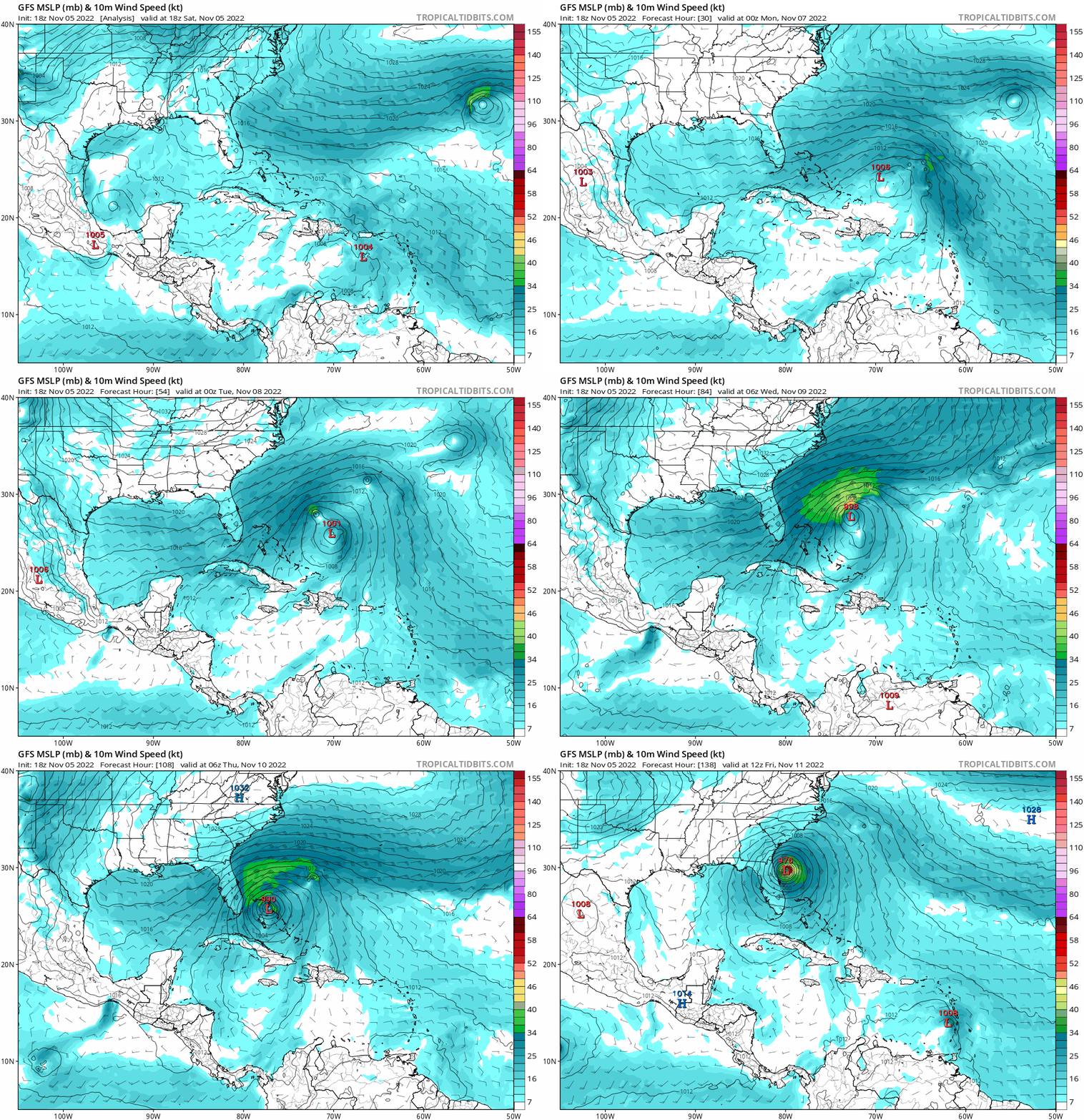
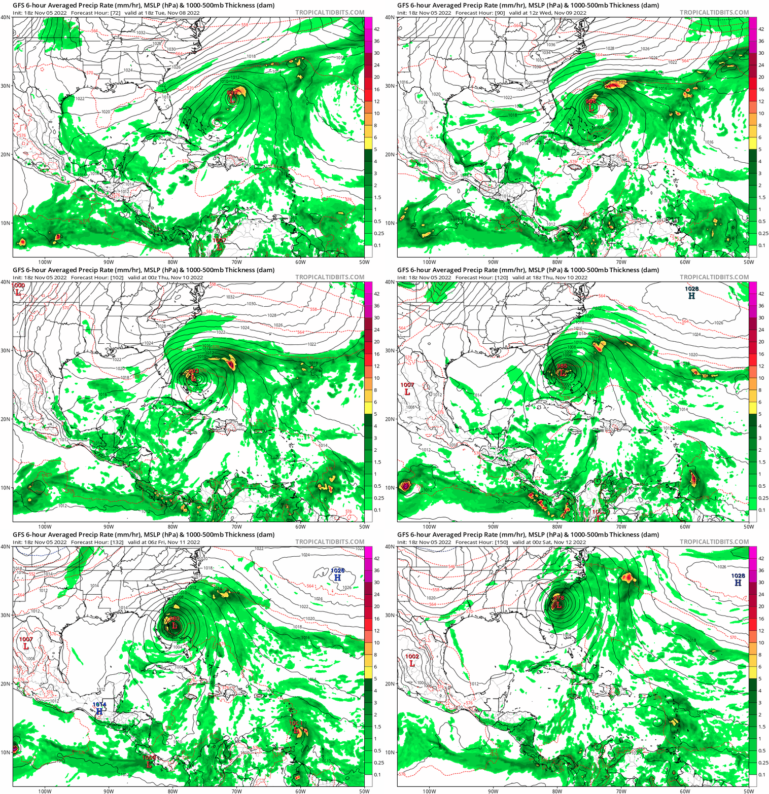
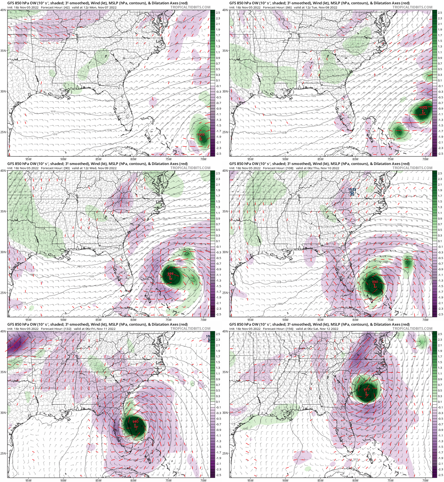
18Z GFS, somehow makes no landfall in the US at all, big change from prior runs. :double:

Image
0 likes   

User avatar
Blown Away
S2K Supporter
S2K Supporter
Posts: 9867
Joined: Wed May 26, 2004 6:17 am

Re: Possible Development Near the GA/Bahamas Early Next Week (40/70)

#254 Postby Blown Away » Sat Nov 05, 2022 5:25 pm

Image

18z GFS… CONUS miss after Bahamas… Much slower than previous runs and some weird big gyre before Bahamas…
0 likes   
Hurricane Eye Experience: David 79, Irene 99, Frances 04, Jeanne 04, Wilma 05... EYE COMING MY WAY IN 2024…
Hurricane Brush Experience: Andrew 92, Erin 95, Floyd 99, Matthew 16, Irma 17, Ian 22, Nicole 22…

jlauderdal
S2K Supporter
S2K Supporter
Posts: 6776
Joined: Wed May 19, 2004 5:46 am
Location: NE Fort Lauderdale
Contact:

Re: RE: Re: Possible Development Near the GA/Bahamas Early Next Week (40/70)

#255 Postby jlauderdal » Sat Nov 05, 2022 5:34 pm

Blown Away wrote:Image

18z GFS… CONUS miss after Bahamas… Much slower than previous runs and some weird big gyre before Bahamas…
Yeah, the gyre deal seems highly unlikely, toss it
0 likes   

User avatar
gatorcane
S2K Supporter
S2K Supporter
Posts: 23499
Age: 46
Joined: Sun Mar 13, 2005 3:54 pm
Location: Boca Raton, FL

Re: Possible Development Near the GA/Bahamas Early Next Week (40/70)

#256 Postby gatorcane » Sat Nov 05, 2022 5:34 pm

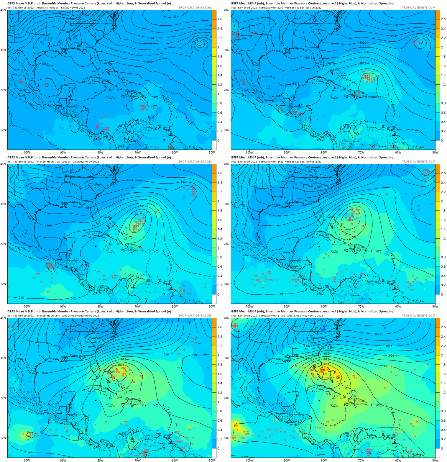
The GFS ensembles are coming in stronger so far and look to generally head into South Florida, not the recurve at the last minute before Florida the OP is showing.

Image
Last edited by gatorcane on Sat Nov 05, 2022 5:39 pm, edited 1 time in total.
2 likes   

User avatar
N2FSU
S2K Supporter
S2K Supporter
Posts: 1010
Joined: Thu Sep 04, 2003 2:04 pm
Location: Tallahassee, FL

Re: Possible Development Near the GA/Bahamas Early Next Week (40/70)

#257 Postby N2FSU » Sat Nov 05, 2022 5:39 pm

GFS is slower and misses Florida because of a weird Fujiwara thing. Throw this run out.
2 likes   

User avatar
blp
Category 5
Category 5
Posts: 2807
Age: 45
Joined: Thu Sep 09, 2004 7:51 pm
Location: Miami, FL
Contact:

Re: Possible Development Near the GA/Bahamas Early Next Week (40/70)

#258 Postby blp » Sat Nov 05, 2022 6:18 pm

We need an invest on this. Too much model support to be ignored any longer. Interesting to see what the HWRF does with this.
3 likes   
The following post is NOT an official forecast and should not be used as such. It is just the opinion of the poster and may or may not be backed by sound meteorological data. It is NOT endorsed by any professional institution including storm2k.org For Official Information please refer to the NHC and NWS products.

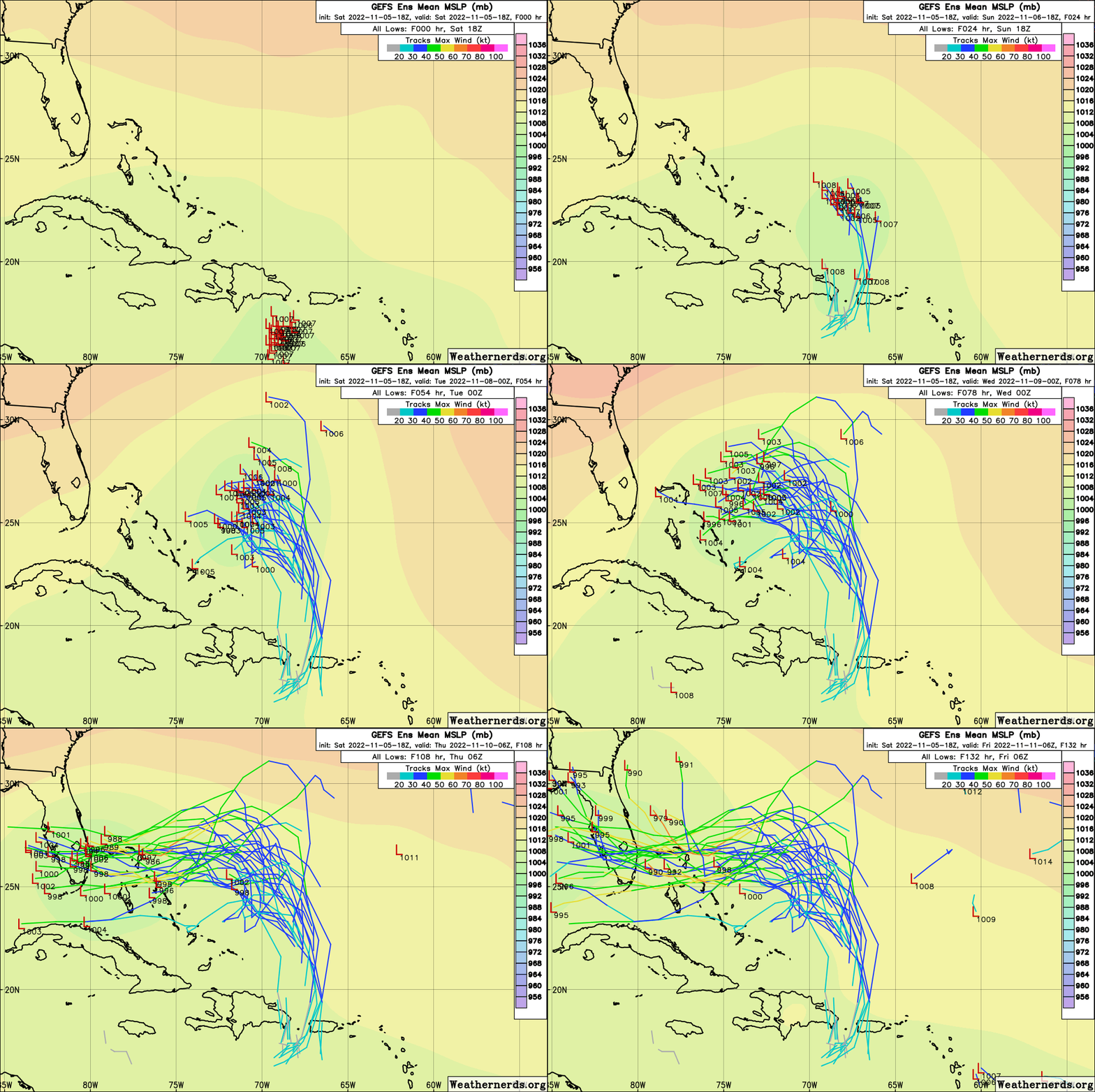
User avatar
Blown Away
S2K Supporter
S2K Supporter
Posts: 9867
Joined: Wed May 26, 2004 6:17 am

Re: Possible Development Near the GA/Bahamas Early Next Week (40/70)

#259 Postby Blown Away » Sat Nov 05, 2022 6:21 pm

Image

18z GEFS… Many more greens, yellows, and now a few oranges… Appears the more latitude our AOI gets before HP pushes SW the longer it takes getting to CONUS and trough could catch it and miss… Majority of GEFS show FL impact in 4+ days…
0 likes   
Hurricane Eye Experience: David 79, Irene 99, Frances 04, Jeanne 04, Wilma 05... EYE COMING MY WAY IN 2024…
Hurricane Brush Experience: Andrew 92, Erin 95, Floyd 99, Matthew 16, Irma 17, Ian 22, Nicole 22…

User avatar
cycloneye
Admin
Admin
Posts: 139344
Age: 67
Joined: Thu Oct 10, 2002 10:54 am
Location: San Juan, Puerto Rico

Re: Possible Development Near the GA/Bahamas Early Next Week (50/80)

#260 Postby cycloneye » Sat Nov 05, 2022 6:48 pm

50/80.

Southwestern Atlantic:
A trough of low pressure located over the northeastern Caribbean Sea
is producing a large area of disorganized showers and thunderstorms.
The trough is forecast to move northward over the southwestern
Atlantic on Sunday, where a broad area of low pressure is expected
to form north of Hispaniola. Environmental conditions are forecast
to be conducive for gradual development, and a subtropical or
tropical depression is likely to form early next week while the
system moves generally westward to west-northwestward over the
southwestern Atlantic. Regardless of development, there is an
increasing risk of coastal flooding, gale-force winds, heavy
rainfall, rough surf, and beach erosion along much of the
southeastern United States coast, the Florida east coast, and
portions of the central and northwestern Bahamas during the early to
middle part of next week. The disturbance is also expected to bring
locally heavy rainfall to Puerto Rico and the Virgin Islands this
weekend. Interests in those areas should monitor the progress of
this system.
* Formation chance through 48 hours...medium...50 percent.
* Formation chance through 5 days...high...80 percent.
0 likes   
Visit the Caribbean-Central America Weather Thread where you can find at first post web cams,radars
and observations from Caribbean basin members Click Here


Return to “Talkin' Tropics”

Who is online

Users browsing this forum: CFLHurricane, IcyTundra, Stratton23, Teban54, zzzh and 47 guests