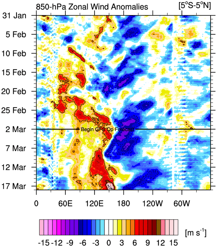
2026 ENSO Updates

This is the general tropical discussion area. Anyone can take their shot at predicting a storms path.

Moderator: S2k Moderators

Forum rules

The posts in this forum are NOT official forecasts and should not be used as such. They are just the opinion of the poster and may or may not be backed by sound meteorological data. They are NOT endorsed by any professional institution or STORM2K. For official information, please refer to products from the National Hurricane Center and National Weather Service.

Help Support Storm2K
Message
Author
mixedDanilo.E
Tropical Storm
Tropical Storm
Posts: 100
Joined: Sun Nov 21, 2021 8:00 am
Location: NY

Re: 2026 ENSO Updates

#241 Postby mixedDanilo.E » Thu Feb 26, 2026 5:05 pm

cycloneye wrote:
Kingarabian wrote:NCEP models are all in on a strong MJO in the WPAC. Euro is still weaker.


Do you have graphic(s)?


Image
Image

Long range GEFS and CFS
1 likes   

User avatar
cycloneye
Admin
Admin
Posts: 149214
Age: 69
Joined: Thu Oct 10, 2002 10:54 am
Location: San Juan, Puerto Rico

Re: 2026 ENSO Updates

#242 Postby cycloneye » Fri Feb 27, 2026 6:50 pm

0 likes   
Visit the Caribbean-Central America Weather Thread where you can find at first post web cams,radars
and observations from Caribbean basin members Click Here

User avatar
Kingarabian
S2K Supporter
S2K Supporter
Posts: 16342
Joined: Sat Aug 08, 2009 3:06 am
Location: Honolulu, Hawaii

Re: 2026 ENSO Updates

#243 Postby Kingarabian » Fri Feb 27, 2026 9:44 pm


Need the - OLR anomalies further east than that :uarrow:

Waiting for the Euro to get on board for a big WPAC MJO event still.
1 likes   
RIP Kobe Bryant

User avatar
cycloneye
Admin
Admin
Posts: 149214
Age: 69
Joined: Thu Oct 10, 2002 10:54 am
Location: San Juan, Puerto Rico

Re: 2026 ENSO Updates

#244 Postby cycloneye » Sat Feb 28, 2026 1:22 pm

0 likes   
Visit the Caribbean-Central America Weather Thread where you can find at first post web cams,radars
and observations from Caribbean basin members Click Here

User avatar
cycloneye
Admin
Admin
Posts: 149214
Age: 69
Joined: Thu Oct 10, 2002 10:54 am
Location: San Juan, Puerto Rico

Re: 2026 ENSO Updates

#245 Postby cycloneye » Sun Mar 01, 2026 8:37 am

Few words but may be very important down the road.

 https://x.com/PaulRoundy1/status/2028081575246577782

0 likes   
Visit the Caribbean-Central America Weather Thread where you can find at first post web cams,radars
and observations from Caribbean basin members Click Here

User avatar
cycloneye
Admin
Admin
Posts: 149214
Age: 69
Joined: Thu Oct 10, 2002 10:54 am
Location: San Juan, Puerto Rico

Re: 2026 ENSO Updates

#246 Postby cycloneye » Sun Mar 01, 2026 3:40 pm

MJO amplification on phase 7 from ECMWF.

Image
0 likes   
Visit the Caribbean-Central America Weather Thread where you can find at first post web cams,radars
and observations from Caribbean basin members Click Here

User avatar
DorkyMcDorkface
Category 4
Category 4
Posts: 980
Age: 28
Joined: Mon Sep 30, 2019 1:32 pm
Location: Mid-Atlantic

Re: 2026 ENSO Updates

#247 Postby DorkyMcDorkface » Sun Mar 01, 2026 5:39 pm

cycloneye wrote:MJO amplification on phase 7 from ECMWF.

https://i.imgur.com/dA4FlAA.jpeg

I think "amplification" is generous, the ensembles are all over the place and the mean is hovering pretty close to null. Compare to the GEFS which has more members that very clearly show an amplified signal (although the mean itself isn't super impressive). Remains to be seen as to whether or not this is a byproduct of its known WPAC MJO bias though
Image
2 likes   
Please note the thougths expressed by this account are solely those of the user and are from a hobbyist perspective. For more comprehensive analysis, consult an actual professional meteorologist or meteorology agency.


Floyd 1999 | Isabel 2003 | Hanna 2008 | Irene 2011 | Sandy 2012 | Isaias 2020

User avatar
Yellow Evan
Professional-Met
Professional-Met
Posts: 16222
Age: 27
Joined: Fri Jul 15, 2011 12:48 pm
Location: Henderson, Nevada/Honolulu, HI
Contact:

Re: 2026 ENSO Updates

#248 Postby Yellow Evan » Sun Mar 01, 2026 7:50 pm

:uarrow: EPS extended range has definitely trended upwards towards Pacific westerlies. See https://charts.ecmwf.int/products/mofc_ ... 0850%20hPa
0 likes   

User avatar
Kingarabian
S2K Supporter
S2K Supporter
Posts: 16342
Joined: Sat Aug 08, 2009 3:06 am
Location: Honolulu, Hawaii

Re: 2026 ENSO Updates

#249 Postby Kingarabian » Sun Mar 01, 2026 9:08 pm

Big WPAC WWB on the GFS now. Let's see if it verifies compared to the late December bust.
0 likes   
RIP Kobe Bryant

User avatar
cycloneye
Admin
Admin
Posts: 149214
Age: 69
Joined: Thu Oct 10, 2002 10:54 am
Location: San Juan, Puerto Rico

Re: 2026 ENSO Updates

#250 Postby cycloneye » Mon Mar 02, 2026 7:02 am

BoM has Niño 3.4 going up to +2.0C by August and has Niño 3 up to +2.7C also by August.

https://www.bom.gov.au/climate/ocean/ou ... abs=Graphs

Image

Image
0 likes   
Visit the Caribbean-Central America Weather Thread where you can find at first post web cams,radars
and observations from Caribbean basin members Click Here

jconsor
Professional-Met
Professional-Met
Posts: 577
Joined: Mon Jun 30, 2008 9:31 pm
Location: Jerusalem, Israel
Contact:

Re: 2026 ENSO Updates

#251 Postby jconsor » Mon Mar 02, 2026 8:31 am

Scott is an experienced long range forecaster who clearly explains his reasoning. He intimates that the gap between atmospheric impacts of El Nino and the SST anomalies in the ENSO region may be even larger than 2023:

https://www.linkedin.com/posts/scott-yu ... 7X02RAnqV4
0 likes   

jconsor
Professional-Met
Professional-Met
Posts: 577
Joined: Mon Jun 30, 2008 9:31 pm
Location: Jerusalem, Israel
Contact:

Re: 2026 ENSO Updates

#252 Postby jconsor » Mon Mar 02, 2026 8:37 am

My personal take on Scott's LinkedIn post:
One important diference between 2023 and 2026 is that warmest SST anomalies in spring-summer 2023 were well concentrated in the tropics (a rare phenomenon prior to an El Nino, likely related to Hunga Tonga eruption). Meanwhile what we are seeing this year so far is warmest anomalies concentrated in the mid-latitudes (especially NW Pacific and NW Atlantic). No sign from climate models that will change by the time hurricane season is underway.

So while I think the road to good atmospheric coupling will be bumpy and we likely will see WWBs struggle to cross the dateline at times, it's hard for me to imagine the Atlantic would be as favorable as 2023.

Also re: Scott's last sentence about the global SST (anomalies) being twice as high/warm as 2023 (at this point e.g. beginning of Mar). While that is true when averaging global SST anomalies,

1) The global anomalies will have a hard time keeping up with 2023 heading into late spring-early summer, absent any large volcanic eruption trapping water vapor in atmosphere like Hunga Tonga

2) The warmth is less concentrated in the Atlantic and Indian Ocean vs Pacific this year than spring 2023

jconsor wrote:Scott is an experienced long range forecaster who clearly explains his reasoning. He intimates that the gap between atmospheric impacts of El Nino and the SST anomalies in the ENSO region may be even larger than 2023:

https://www.linkedin.com/posts/scott-yu ... 7X02RAnqV4
Last edited by jconsor on Mon Mar 02, 2026 9:15 am, edited 1 time in total.
1 likes   

User avatar
cycloneye
Admin
Admin
Posts: 149214
Age: 69
Joined: Thu Oct 10, 2002 10:54 am
Location: San Juan, Puerto Rico

Re: 2026 ENSO Updates

#253 Postby cycloneye » Mon Mar 02, 2026 9:10 am

1 likes   
Visit the Caribbean-Central America Weather Thread where you can find at first post web cams,radars
and observations from Caribbean basin members Click Here

User avatar
cycloneye
Admin
Admin
Posts: 149214
Age: 69
Joined: Thu Oct 10, 2002 10:54 am
Location: San Juan, Puerto Rico

Re: 2026 ENSO Updates

#254 Postby cycloneye » Mon Mar 02, 2026 10:17 am

The weekly CPC update of 3/2/26 has niño 3.4 at -0.6C.

https://www.cpc.ncep.noaa.gov/products/ ... ts-web.pdf
0 likes   
Visit the Caribbean-Central America Weather Thread where you can find at first post web cams,radars
and observations from Caribbean basin members Click Here

User avatar
DorkyMcDorkface
Category 4
Category 4
Posts: 980
Age: 28
Joined: Mon Sep 30, 2019 1:32 pm
Location: Mid-Atlantic

Re: 2026 ENSO Updates

#255 Postby DorkyMcDorkface » Mon Mar 02, 2026 10:27 am


That's more like what you'd expect in a (developing) Niño atmospheric response, especially given how volatile ENSO is this time of year
1 likes   

Please note the thougths expressed by this account are solely those of the user and are from a hobbyist perspective. For more comprehensive analysis, consult an actual professional meteorologist or meteorology agency.


Floyd 1999 | Isabel 2003 | Hanna 2008 | Irene 2011 | Sandy 2012 | Isaias 2020

User avatar
cycloneye
Admin
Admin
Posts: 149214
Age: 69
Joined: Thu Oct 10, 2002 10:54 am
Location: San Juan, Puerto Rico

Re: 2026 ENSO Updates

#256 Postby cycloneye » Mon Mar 02, 2026 10:42 am

0 likes   
Visit the Caribbean-Central America Weather Thread where you can find at first post web cams,radars
and observations from Caribbean basin members Click Here

User avatar
Kingarabian
S2K Supporter
S2K Supporter
Posts: 16342
Joined: Sat Aug 08, 2009 3:06 am
Location: Honolulu, Hawaii

Re: 2026 ENSO Updates

#257 Postby Kingarabian » Mon Mar 02, 2026 12:54 pm

Image

Let's see how this evolves.
0 likes   
RIP Kobe Bryant

User avatar
Ntxw
Storm2k Moderator
Storm2k Moderator
Posts: 23461
Joined: Wed Oct 21, 2009 6:34 pm
Location: DFW, Texas

Re: 2026 ENSO Updates

#258 Postby Ntxw » Mon Mar 02, 2026 1:14 pm

It won't take much to push the thermocline a little more. We aren't at the levels 2015 was, which depressed it much more so but more in line with 2009-2023 look to it, at this early stage. April will likely feature another round to further push the waters.

Image

Image

Image

Surface remaining cool anomalies are shallow and reserved to the west-central basin. Once that gets flushed out, weeklies will steadily climb as warmer waters pinch in from both the west and the east.
3 likes   
The above post and any post by Ntxw is NOT an official forecast and should not be used as such. It is just the opinion of the poster and may or may not be backed by sound meteorological data. It is NOT endorsed by any professional institution including Storm2k. For official information, please refer to NWS products.

  Help support Storm2K!
Help Support Storm2K

zzzh
Category 5
Category 5
Posts: 1032
Joined: Thu Sep 02, 2021 1:13 pm

Re: 2026 ENSO Updates

#259 Postby zzzh » Mon Mar 02, 2026 6:33 pm

Image
Image
Models are forecasting strong westerlies north of the equator with slightly enhanced trades on the south side. This doesn't look like 1997 or 2015, which they had strong equatorial WWB with a focus on the southern side. It does look very similar to other Nino years though
0 likes   


Return to “Talkin' Tropics”

Who is online

Users browsing this forum: No registered users and 77 guests