

Confirming model support on both.
2021 Global Model Runs Discussion (Out thru day 16)
Moderator: S2k Moderators
Forum rules

The posts in this forum are NOT official forecasts and should not be used as such. They are just the opinion of the poster and may or may not be backed by sound meteorological data. They are NOT endorsed by any professional institution or STORM2K. For official information, please refer to products from the National Hurricane Center and National Weather Service.
Re: 2021 Global Model Runs Discussion (Out thru day 16)
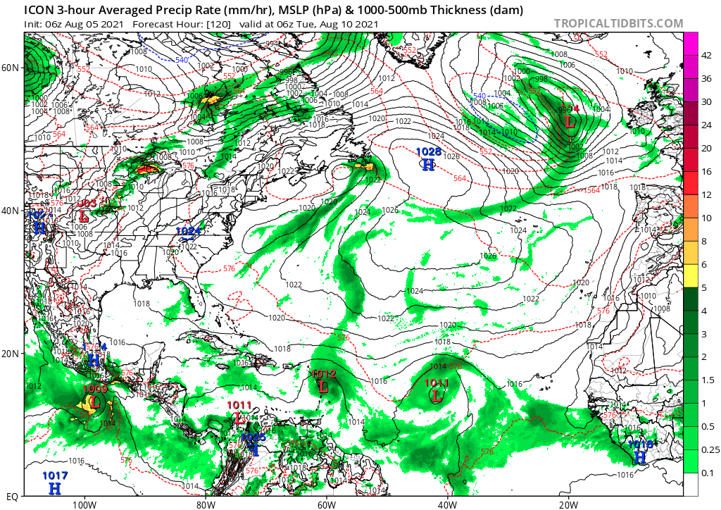
ICON is picking up on two possible TCs
Confirming model support on both.
Confirming model support on both.
1 likes
-
jconsor
- Professional-Met

- Posts: 580
- Joined: Mon Jun 30, 2008 9:31 pm
- Location: Jerusalem, Israel
- Contact:
Re: 2021 Global Model Runs Discussion (Out thru day 16)
Better resolution CFS forecast maps are available at:
https://www.pivotalweather.com/model.ph ... &dpdt=&mc= (N America/Caribbean/W Atlantic)
https://www.pivotalweather.com/model.ph ... h_nb&m=cfs (E Atlantic/W Africa)
https://weather.cod.edu/forecast/ (click on CFS in menu, then North America domain)
https://www.pivotalweather.com/model.ph ... &dpdt=&mc= (N America/Caribbean/W Atlantic)
https://www.pivotalweather.com/model.ph ... h_nb&m=cfs (E Atlantic/W Africa)
https://weather.cod.edu/forecast/ (click on CFS in menu, then North America domain)
Stormybajan wrote:Category5Kaiju wrote:aspen wrote:00z CFS is suggesting that a storm could form in the eastern MDR in the August 21st-25th and become a monster of a Cape Verde storm in the following week. This is obviously really far out, but the model has been consistent suggesting an increase in MDR activity after we hit the August 20th mark.
Do you mind if you share the link to that run? I for some reason am not sure where exactly to find the CFS runs?
https://www.weatheronline.co.uk/cgi-bin/expertcharts?LANG=en&MENU=0000000000&CONT=noat&MODELL=cfs&MODELLTYP=1&BASE=-&VAR=pslv&HH=12&ZOOM=0&WMO=&ARCHIV=0&LOOP=1&RES=0
0 likes
-
AlphaToOmega
- Category 5

- Posts: 1448
- Joined: Sat Jun 26, 2021 10:51 am
- Location: Somewhere in Massachusetts
Re: 2021 Global Model Runs Discussion (Out thru day 16)
jconsor wrote:Better resolution CFS forecast maps are available at:
https://www.pivotalweather.com/model.ph ... &dpdt=&mc= (N America/Caribbean/W Atlantic)
https://www.pivotalweather.com/model.ph ... h_nb&m=cfs (E Atlantic/W Africa)
https://weather.cod.edu/forecast/ (click on CFS in menu, then North America domain)Stormybajan wrote:Category5Kaiju wrote:
Do you mind if you share the link to that run? I for some reason am not sure where exactly to find the CFS runs?
https://www.weatheronline.co.uk/cgi-bin/expertcharts?LANG=en&MENU=0000000000&CONT=noat&MODELL=cfs&MODELLTYP=1&BASE=-&VAR=pslv&HH=12&ZOOM=0&WMO=&ARCHIV=0&LOOP=1&RES=0
If we are to trust the CFS run (and I am very skeptical of a model run 672 hours out
0 likes
Re: 2021 Global Model Runs Discussion (Out thru day 16)
Interesting, to say the least.
In 4 days, the African Easterly Jet all but disappears.
In 4 days, the African Easterly Jet all but disappears.
2 likes

Re: 2021 Global Model Runs Discussion (Out thru day 16)
jconsor wrote:Better resolution CFS forecast maps are available at:
https://www.pivotalweather.com/model.ph ... &dpdt=&mc= (N America/Caribbean/W Atlantic)
https://www.pivotalweather.com/model.ph ... h_nb&m=cfs (E Atlantic/W Africa)
https://weather.cod.edu/forecast/ (click on CFS in menu, then North America domain)Stormybajan wrote:Category5Kaiju wrote:
Do you mind if you share the link to that run? I for some reason am not sure where exactly to find the CFS runs?
https://www.weatheronline.co.uk/cgi-bin/expertcharts?LANG=en&MENU=0000000000&CONT=noat&MODELL=cfs&MODELLTYP=1&BASE=-&VAR=pslv&HH=12&ZOOM=0&WMO=&ARCHIV=0&LOOP=1&RES=0
I hope the CFS is nowhere near right about Hurricane Fred plowing right into Connecticut in a few weeks.
0 likes
Irene '11 Sandy '12 Hermine '16 5/15/2018 Derecho Fay '20 Isaias '20 Elsa '21 Henri '21 Ida '21
I am only a meteorology enthusiast who knows a decent amount about tropical cyclones. Look to the professional mets, the NHC, or your local weather office for the best information.
I am only a meteorology enthusiast who knows a decent amount about tropical cyclones. Look to the professional mets, the NHC, or your local weather office for the best information.
Re: 2021 Global Model Runs Discussion (Out thru day 16)
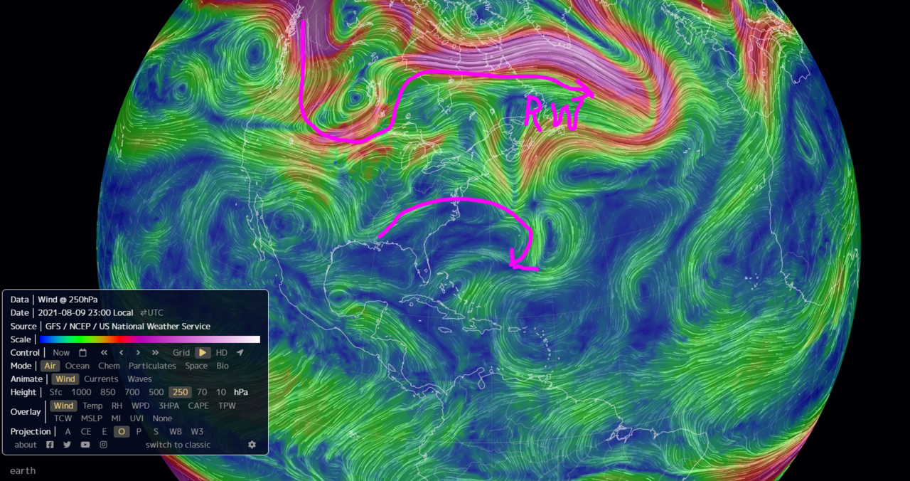
The Blocking High over the NW CONUS has broken down.
This was hindering any ARWB from developing in the GOM / MDR.
With the upper troposphere cooling off, Rossby Waves will be dropping further south creating good ARWBs to occur in the TC development regions in the next couple weeks.
Looks like these waves will have potential to develop.
This was hindering any ARWB from developing in the GOM / MDR.
With the upper troposphere cooling off, Rossby Waves will be dropping further south creating good ARWBs to occur in the TC development regions in the next couple weeks.
Looks like these waves will have potential to develop.
4 likes
-
Shell Mound
- Category 5
- Posts: 2432
- Age: 33
- Joined: Thu Sep 07, 2017 3:39 pm
- Location: St. Petersburg, FL → Scandinavia
Re: 2021 Global Model Runs Discussion (Out thru day 16)
jconsor wrote:Look to the western Atlantic and Caribbean for development as we approach mid-August.
https://twitter.com/yconsor/status/1423240994452017157
The EPS no longer develops the western system to any significant degree. It only focuses on the eastern system, which gets ejected OTS due to the monsoon.
0 likes
CVW / MiamiensisWx / Shell Mound
The posts in this forum are NOT official forecasts and should not be used as such. They are just the opinion of the poster and may or may not be backed by sound meteorological data. They are NOT endorsed by any professional institution or STORM2K. For official information, please refer to products from the NHC and NWS.
Re: 2021 Global Model Runs Discussion (Out thru day 16)
GCANE wrote:The Blocking High over the NW CONUS has broken down.
This was hindering any ARWB from developing in the GOM / MDR.
With the upper troposphere cooling off, Rossby Waves will be dropping further south creating good ARWBs to occur in the TC development regions in the next couple weeks.
Looks like these waves will have potential to develop.
[url]https://i.postimg.cc/T3rB8C9t/RW1.png [/url]
What are ARWBs, and how do they influence TCG?
0 likes
Irene '11 Sandy '12 Hermine '16 5/15/2018 Derecho Fay '20 Isaias '20 Elsa '21 Henri '21 Ida '21
I am only a meteorology enthusiast who knows a decent amount about tropical cyclones. Look to the professional mets, the NHC, or your local weather office for the best information.
I am only a meteorology enthusiast who knows a decent amount about tropical cyclones. Look to the professional mets, the NHC, or your local weather office for the best information.
Re: 2021 Global Model Runs Discussion (Out thru day 16)
aspen wrote:GCANE wrote:The Blocking High over the NW CONUS has broken down.
This was hindering any ARWB from developing in the GOM / MDR.
With the upper troposphere cooling off, Rossby Waves will be dropping further south creating good ARWBs to occur in the TC development regions in the next couple weeks.
Looks like these waves will have potential to develop.
[url]https://i.postimg.cc/T3rB8C9t/RW1.png [/url]
What are ARWBs, and how do they influence TCG?
ARWB = Anticyclonic Rossby Wave Break
They occur around 250mb altitude and on the SE side of the bottom trof of a Rossby Wave.
The general public knows Rossby Waves as the Jet Stream.
The region of a ARWB creates lift in the troposphere allowing convection to develop.
Most of the strong TCs develop within ARWBs.
8 likes
-
Category5Kaiju

- Category 5
- Posts: 4334
- Joined: Thu Dec 24, 2020 12:45 pm
- Location: Seattle and Phoenix
Re: 2021 Global Model Runs Discussion (Out thru day 16)
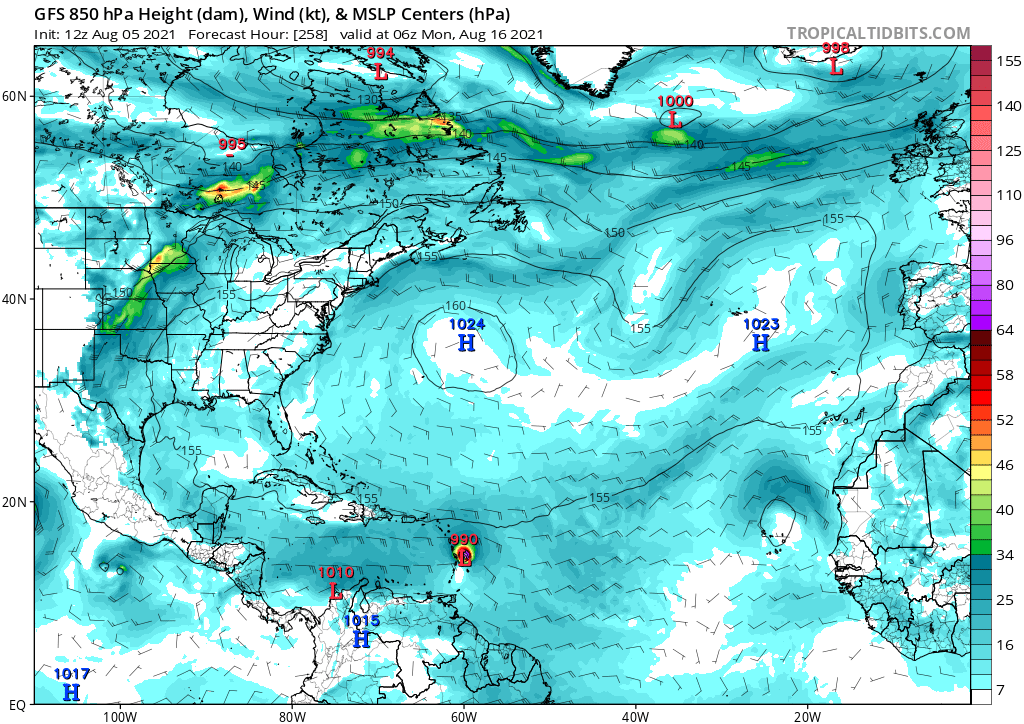
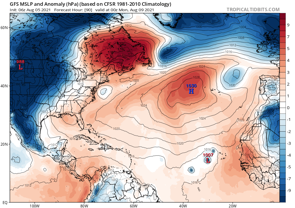
AlphaToOmega wrote:There are four storms in this model: three near Cape Verde and one near the East Coast. This gets us Fred, Grace, Henri, and Ida. Plus, if the system in the Gulf develops, that gets us to Julian.
https://i.postimg.cc/vTV1nMyt/gfs-mslpa-atl-16.png
While I am not saying it is impossible, I would be a bit careful with classifying the East Coast system as a TC; this year at least so far we have not been getting these TCs spin up as easily near the Eastern Seaboard like last year, although I may be wrong
2 likes
Unless explicitly stated, all info in my posts is based on my own opinions and observations. Tropical storms and hurricanes can be extremely dangerous. Refer to an accredited weather research agency or meteorologist if you need to make serious decisions regarding an approaching storm.
Re: 2021 Global Model Runs Discussion (Out thru day 16)
12z GFS has a low off of the Mid-Atlantic seemingly attempting to spin up into something by 102hr.
Update: now there’s a tiny Cape Verde low-rider that forms by August 13th.
Update: now there’s a tiny Cape Verde low-rider that forms by August 13th.
2 likes
Irene '11 Sandy '12 Hermine '16 5/15/2018 Derecho Fay '20 Isaias '20 Elsa '21 Henri '21 Ida '21
I am only a meteorology enthusiast who knows a decent amount about tropical cyclones. Look to the professional mets, the NHC, or your local weather office for the best information.
I am only a meteorology enthusiast who knows a decent amount about tropical cyclones. Look to the professional mets, the NHC, or your local weather office for the best information.
-
AlphaToOmega
- Category 5
- Posts: 1448
- Joined: Sat Jun 26, 2021 10:51 am
- Location: Somewhere in Massachusetts
-
captainbarbossa19

- Professional-Met
- Posts: 1094
- Age: 27
- Joined: Wed Aug 21, 2019 11:09 pm
- Location: Beaumont, TX
Re: 2021 Global Model Runs Discussion (Out thru day 16)
AlphaToOmega wrote:https://i.postimg.cc/t4G8NYnm/gfs-mslp-uv850-atl-44.png
Surprisingly, the models are actually showing storms. Then again, these could be phantom ones. I think we are going to see a TC soon in the MDR though.
2 likes

Re: 2021 Global Model Runs Discussion (Out thru day 16)
captainbarbossa19 wrote:AlphaToOmega wrote:https://i.postimg.cc/t4G8NYnm/gfs-mslp-uv850-atl-44.png
Surprisingly, the models are actually showing storms. Then again, these could be phantom ones. I think we are going to see a TC soon in the MDR though.
Ensembles don’t really have anything of interest in the western part of the basin yet. I suppose that’ll change in another week or two. I couldn’t care less about what happens elsewhere but that’s just me.
3 likes
-
Stormybajan

- Category 1

- Posts: 453
- Joined: Thu May 20, 2021 3:21 pm
- Location: Windward Islands
Re: 2021 Global Model Runs Discussion (Out thru day 16)
3 likes
Sad West Indies and Manchester United fan ⚽️
Re: 2021 Global Model Runs Discussion (Out thru day 16)
Yes, I believe so. Strong convection firing to the se of the islands off the coast of Africa.
0 likes
Re: 2021 Global Model Runs Discussion (Out thru day 16)
The next month according to today’s CFS:
—Hurricane Fred making it to the East Coast by mid-August
—Grace forming in the subtropics and Henri forming in the MDR right after the August 20th “bell-ringing” mark
—A bit of a break in the 1st week of September
—Hurricane Julian forming in the MDR at the start of the second week of September
These are far out and likely to change, but this does tell us that there’s potential for multiple MDR storms — possibly a few long-tracking hurricanes — over the next few weeks, as well as some action in the subtropics in two weeks. The CFS has also significantly favored 92L over any other wave currently out there or set to emerge before August 20th, but there’s always a chance it misses some storms.
3 likes
Irene '11 Sandy '12 Hermine '16 5/15/2018 Derecho Fay '20 Isaias '20 Elsa '21 Henri '21 Ida '21
I am only a meteorology enthusiast who knows a decent amount about tropical cyclones. Look to the professional mets, the NHC, or your local weather office for the best information.
I am only a meteorology enthusiast who knows a decent amount about tropical cyclones. Look to the professional mets, the NHC, or your local weather office for the best information.
Re: 2021 Global Model Runs Discussion (Out thru day 16)
We might need to watch an area off the Mid-Atlantic/NE Coast starting late Sunday.
0 likes
Irene '11 Sandy '12 Hermine '16 5/15/2018 Derecho Fay '20 Isaias '20 Elsa '21 Henri '21 Ida '21
I am only a meteorology enthusiast who knows a decent amount about tropical cyclones. Look to the professional mets, the NHC, or your local weather office for the best information.
I am only a meteorology enthusiast who knows a decent amount about tropical cyclones. Look to the professional mets, the NHC, or your local weather office for the best information.
-
Category5Kaiju
- Category 5
- Posts: 4334
- Joined: Thu Dec 24, 2020 12:45 pm
- Location: Seattle and Phoenix
Re: 2021 Global Model Runs Discussion (Out thru day 16)
The latest GFS run is interesting to say the least; it develops two concentrated areas of spin with 92L, then has a wave go right over Venezuela and Colombia westward and develop into a storm that hits Nicaragua.
0 likes
Unless explicitly stated, all info in my posts is based on my own opinions and observations. Tropical storms and hurricanes can be extremely dangerous. Refer to an accredited weather research agency or meteorologist if you need to make serious decisions regarding an approaching storm.
-
Stormybajan
- Category 1
- Posts: 453
- Joined: Thu May 20, 2021 3:21 pm
- Location: Windward Islands
Re: 2021 Global Model Runs Discussion (Out thru day 16)
Category5Kaiju wrote:The latest GFS run is funny; it develops two concentrated areas of spin with 92L, then has a wave go right over Venezuela and Colombia westward and develop into a storm that hits Nicaragua.
I have NEVER seen a tropical cyclone so close Guyana in history lol. Im not sure whats going on there
2 likes
Sad West Indies and Manchester United fan ⚽️
Who is online
Users browsing this forum: No registered users and 275 guests