ENSO Updates (2007 thru 2023)
Moderator: S2k Moderators
Forum rules
The posts in this forum are NOT official forecasts and should not be used as such. They are just the opinion of the poster and may or may not be backed by sound meteorological data. They are NOT endorsed by any professional institution or STORM2K. For official information, please refer to products from the National Hurricane Center and National Weather Service.
- Hurricaneman
- Category 5

- Posts: 7404
- Age: 45
- Joined: Tue Aug 31, 2004 3:24 pm
- Location: central florida
Re: ENSO Updates
We've been in a positive PDO since 2002 overall which means that any year now it will probably switch negative at some point the next few years
0 likes
Re: ENSO Updates
Kingarabian wrote:Based on the 850mb U-wind Anomalies 5 day averages, the latest GEFS, GFS, and the Euro (to an extent) runs keep the easterlies weak to non existent over the equatorial Pacific. At the same time, they show the easterlies returning and strengthening over the Atlantic MDR, extending into the far eastern Caribbean. That's typically what we see in an El-Nino and this may mean that a broader El-Nino pattern is beginning to take place.. We'll see if this materializes.
I don't know if I want to believe that the easterlies will be above average across the Atlantic MDR, when both the GFS and Euro show the MSLPs to be average to below average with the Azore's High to be non existent thanks to a -NAO over the next few days.
BTW, during El Nino event we see one heck of a low level jet across the central Caribbean, it has yet to materialize in that area nor forecasted by the CFSv2 for the next couple of months.
1 likes
- Yellow Evan
- Professional-Met

- Posts: 16240
- Age: 27
- Joined: Fri Jul 15, 2011 12:48 pm
- Location: Henderson, Nevada/Honolulu, HI
- Contact:
Re: ENSO Updates
Hurricaneman wrote:We've been in a positive PDO since 2002 overall which means that any year now it will probably switch negative at some point the next few years
PDO was largely negative from 1998-2013 (especially after 2007), and positive since 2014.
1 likes
-
dexterlabio
- Category 5

- Posts: 3506
- Joined: Sat Oct 24, 2009 11:50 pm
Re: ENSO Updates
Yellow Evan wrote:Hurricaneman wrote:We've been in a positive PDO since 2002 overall which means that any year now it will probably switch negative at some point the next few years
PDO was largely negative from 1998-2013 (especially after 2007), and positive since 2014.
That's what I thought so, too. I remember we had a lot of talk about the botched 2012 El Nino due to -PDO that seemed to be not going away until 2014.
1 likes
Personal Forecast Disclaimer:
The posts in this forum are NOT official forecast and should not be used as such. They are just the opinion of the poster and may or may not be backed by sound meteorological data. They are NOT endorsed by any professional institution or storm2k.org. For official information, please refer to the NHC and NWS products.
The posts in this forum are NOT official forecast and should not be used as such. They are just the opinion of the poster and may or may not be backed by sound meteorological data. They are NOT endorsed by any professional institution or storm2k.org. For official information, please refer to the NHC and NWS products.
- cycloneye
- Admin

- Posts: 149441
- Age: 69
- Joined: Thu Oct 10, 2002 10:54 am
- Location: San Juan, Puerto Rico
Re: ENSO Updates
0 likes
Visit the Caribbean-Central America Weather Thread where you can find at first post web cams,radars
and observations from Caribbean basin members Click Here
and observations from Caribbean basin members Click Here
- cycloneye
- Admin

- Posts: 149441
- Age: 69
- Joined: Thu Oct 10, 2002 10:54 am
- Location: San Juan, Puerto Rico
Re: ENSO Updates
Trade surge coming.
@MJVentrice
Upcoming strong suppressed Kelvin wave phsae will produce a trade surge over the Pacific during the 2nd-3rd week of May.
https://twitter.com/MJVentrice/status/860127404676837376
@MJVentrice
Upcoming strong suppressed Kelvin wave phsae will produce a trade surge over the Pacific during the 2nd-3rd week of May.
https://twitter.com/MJVentrice/status/860127404676837376
0 likes
Visit the Caribbean-Central America Weather Thread where you can find at first post web cams,radars
and observations from Caribbean basin members Click Here
and observations from Caribbean basin members Click Here
-
WeatherEmperor
- S2K Supporter

- Posts: 4806
- Age: 42
- Joined: Thu Sep 04, 2003 2:54 pm
- Location: South Florida
Re: ENSO Updates
cycloneye wrote:Trade surge coming.
@MJVentrice
Upcoming strong suppressed Kelvin wave phsae will produce a trade surge over the Pacific during the 2nd-3rd week of May.
https://twitter.com/MJVentrice/status/860127404676837376
Luis,
Sorry for the stupid question...but does it help or hurt the chances of El Nino?
Sent from my iPhone 7 using Tapatalk
0 likes
- cycloneye
- Admin

- Posts: 149441
- Age: 69
- Joined: Thu Oct 10, 2002 10:54 am
- Location: San Juan, Puerto Rico
Re: ENSO Updates
WeatherEmperor wrote:cycloneye wrote:Trade surge coming.
@MJVentrice
Upcoming strong suppressed Kelvin wave phsae will produce a trade surge over the Pacific during the 2nd-3rd week of May.
https://twitter.com/MJVentrice/status/860127404676837376
Luis,
Sorry for the stupid question...but does it help or hurt the chances of El Nino?
Sent from my iPhone 7 using Tapatalk
Hurts El Nino chances as waters dont warm with the trades.
0 likes
Visit the Caribbean-Central America Weather Thread where you can find at first post web cams,radars
and observations from Caribbean basin members Click Here
and observations from Caribbean basin members Click Here
-
tolakram
- Admin

- Posts: 20185
- Age: 62
- Joined: Sun Aug 27, 2006 8:23 pm
- Location: Florence, KY (name is Mark)
Re: ENSO Updates
0 likes
M a r k
- - - - -
Join us in chat: Storm2K Chatroom Invite. Android and IOS apps also available.
The posts in this forum are NOT official forecasts and should not be used as such. Posts are NOT endorsed by any professional institution or STORM2K.org. For official information and forecasts, please refer to NHC and NWS products.
- Hurricaneman
- Category 5

- Posts: 7404
- Age: 45
- Joined: Tue Aug 31, 2004 3:24 pm
- Location: central florida
Re: ENSO Updates
0 likes
-
WeatherEmperor
- S2K Supporter

- Posts: 4806
- Age: 42
- Joined: Thu Sep 04, 2003 2:54 pm
- Location: South Florida
Re: ENSO Updates
My head is spinning now. Just a few days ago members like Kingarabian were providing solid evidence that the El Nino is slowly developing and now this? Cfs is backing off its El Nino even more and the Twitter post about trades showing up later this months in the Pacific to potentially slow/halt the Nino. Can somebody pass me a bottle of Jack Daniels???
Sent from my iPhone 7 using Tapatalk
Sent from my iPhone 7 using Tapatalk
2 likes
-
TheStormExpert
Re: ENSO Updates
WeatherEmperor wrote:My head is spinning now. Just a few days ago members like Kingarabian were providing solid evidence that the El Nino is slowly developing and now this? Cfs is backing off its El Nino even more and the Twitter post about trades showing up later this months in the Pacific to potentially slow/halt the Nino. Can somebody pass me a bottle of Jack Daniels???
Sent from my iPhone 7 using Tapatalk
Couldn't agree more! I don't think anyone knows what the outcome will be for this season(especially for the Atlantic). Too much back and forth to even know the littlest bit about what might happen with the ENSO. Just back in January there was no talk of an El Niño and just weeks after that bam, everyone is screaming another El Niño is about to happen.
In my opinion I think if the El Niño were to evolve it will be a Modoki or very weak at that. Atlantic-wise I think we will see very little(if any) effects from this.
0 likes
Re: ENSO Updates
Lol, one day all indications are for a full blown El Nino then the next day we see the contrary. That's the reason for only a 50/50 chance for an El Nino from the Pros 
0 likes
- Kingarabian
- S2K Supporter

- Posts: 16361
- Joined: Sat Aug 08, 2009 3:06 am
- Location: Honolulu, Hawaii
Re: ENSO Updates
To be fair, the CFS keeps getting quoted for some reason and it's the main reason why there's a lot of confusion.
ENSO is composed of many variables. We still don't know everything about it and how it completely works. But it moves very slowly, over a period of time. We can't focus on daily movements/oscillations especially if the indicators don't work that way.
But if you take a look at the main variables for ENSO, there's hard evidence that they favor an El Nino compared to a Neutral and a La Nina. Warm PDO, tanking SOI, warming of the Nino regions, and WWB's. It's all there. These aren't anomalies, or predictions. The Nino regions will continue to warm as these WWB's pass through, and we'll see what this trade burst will do. Because the last one in March was not all that impressive.
0 likes
RIP Kobe Bryant
Re: ENSO Updates
TheStormExpert wrote:WeatherEmperor wrote:My head is spinning now. Just a few days ago members like Kingarabian were providing solid evidence that the El Nino is slowly developing and now this? Cfs is backing off its El Nino even more and the Twitter post about trades showing up later this months in the Pacific to potentially slow/halt the Nino. Can somebody pass me a bottle of Jack Daniels???
Sent from my iPhone 7 using Tapatalk
Couldn't agree more! I don't think anyone knows what the outcome will be for this season(especially for the Atlantic). Too much back and forth to even know the littlest bit about what might happen with the ENSO. Just back in January there was no talk of an El Niño and just weeks after that bam, everyone is screaming another El Niño is about to happen.
In my opinion I think if the El Niño were to evolve it will be a Modoki or very weak at that. Atlantic-wise I think we will see very little(if any) effects from this.
Factors affecting ENSO can change quickly, which results in predictions that can change quickly as well. I suspect we'll see a lot of "back and forth" with the forecasts until we can get a clearer idea of what will happen. But I agree with you, I don't think the effects of an El Niño (if one forms) will be that significant.
1 likes
Igor 2010, Sandy 2012, Fay 2014, Gonzalo 2014, Joaquin 2015, Nicole 2016, Humberto 2019, Imelda 2025
I am only a tropical weather enthusiast. My predictions are not official and may or may not be backed by sound meteorological data. For official information, please refer to the NHC and NWS products.
I am only a tropical weather enthusiast. My predictions are not official and may or may not be backed by sound meteorological data. For official information, please refer to the NHC and NWS products.
- weathaguyry
- Category 5

- Posts: 1273
- Age: 22
- Joined: Wed Jun 15, 2016 5:16 am
- Location: Long Island, NY
Re: ENSO Updates
I had a feeling that something was wrong with the El-NIno when that snake of neutral/below average water formed, because I'm pretty sure that isn't something you see before an El-Nino is about to form. I would say 50/50 of a Weak Modoki/ Warm-Neutral at this point
0 likes
My posts are only my opinions and NOT official forecasts. For official forecasts, consult the National Hurricane Center or the National Weather Service.
Irene 11', Sandy 12', Fay 20’, Isaias 20’, Elsa 21’, Henri 21’, Ida 21’
Irene 11', Sandy 12', Fay 20’, Isaias 20’, Elsa 21’, Henri 21’, Ida 21’
Re: ENSO Updates
WeatherEmperor wrote:My head is spinning now. Just a few days ago members like Kingarabian were providing solid evidence that the El Nino is slowly developing and now this? Cfs is backing off its El Nino even more and the Twitter post about trades showing up later this months in the Pacific to potentially slow/halt the Nino. Can somebody pass me a bottle of Jack Daniels???
Sent from my iPhone 7 using Tapatalk
If you get past the ENSO politics (those favoring Atlantic activity finding data for no Nino, those in Pacific for bigger season there and quiet Atlantic looking for Nino) the empirical data hasn't changed much. Its postive neutral trying for a weak Nino which may sneak out by end of the year
2 likes
The above post and any post by Ntxw is NOT an official forecast and should not be used as such. It is just the opinion of the poster and may or may not be backed by sound meteorological data. It is NOT endorsed by any professional institution including Storm2k. For official information, please refer to NWS products.
- cycloneye
- Admin

- Posts: 149441
- Age: 69
- Joined: Thu Oct 10, 2002 10:54 am
- Location: San Juan, Puerto Rico
Re: ENSO Updates
"Its postive neutral trying for a weak Nino which may sneak out by end of the year"
If that is the case,it may not be too bad for Atlantic at peak ASO.
1 likes
Visit the Caribbean-Central America Weather Thread where you can find at first post web cams,radars
and observations from Caribbean basin members Click Here
and observations from Caribbean basin members Click Here
Re: ENSO Updates
cycloneye wrote::uarrow:
"Its postive neutral trying for a weak Nino which may sneak out by end of the year"
If that is the case,it may not be too bad for Atlantic at peak ASO.
In the end it may not be that ENSO has a huge influence in the Atlantic given a weak event but rather local conditions.
0 likes
The above post and any post by Ntxw is NOT an official forecast and should not be used as such. It is just the opinion of the poster and may or may not be backed by sound meteorological data. It is NOT endorsed by any professional institution including Storm2k. For official information, please refer to NWS products.
- weathaguyry
- Category 5

- Posts: 1273
- Age: 22
- Joined: Wed Jun 15, 2016 5:16 am
- Location: Long Island, NY
Re: ENSO Updates
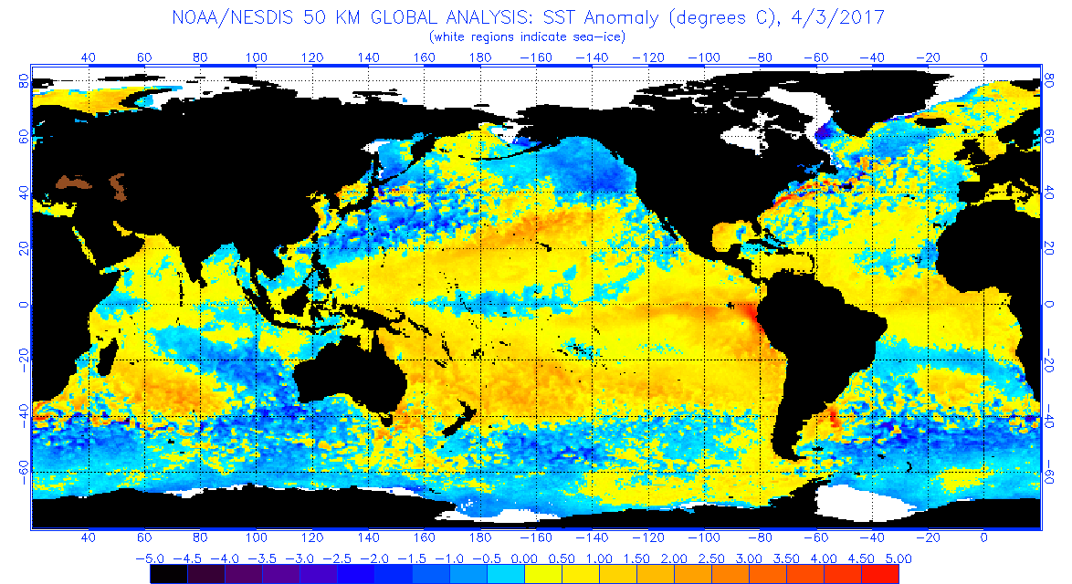
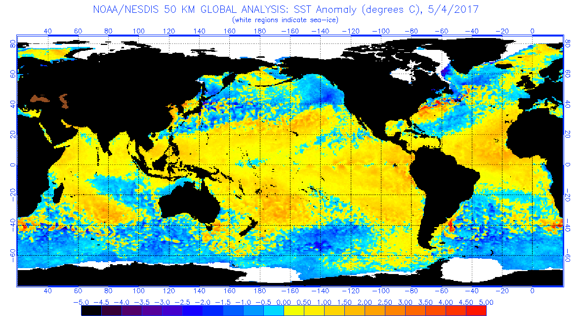
You can see the difference a month makes in terms of an El-Nino trying to form...


0 likes
My posts are only my opinions and NOT official forecasts. For official forecasts, consult the National Hurricane Center or the National Weather Service.
Irene 11', Sandy 12', Fay 20’, Isaias 20’, Elsa 21’, Henri 21’, Ida 21’
Irene 11', Sandy 12', Fay 20’, Isaias 20’, Elsa 21’, Henri 21’, Ida 21’
Who is online
Users browsing this forum: hurricanes1234 and 607 guests


