GFS/NAM Develop a Closed Low in the GOM End of This Week

This is the general tropical discussion area. Anyone can take their shot at predicting a storms path.

Moderator: S2k Moderators

Forum rules

The posts in this forum are NOT official forecasts and should not be used as such. They are just the opinion of the poster and may or may not be backed by sound meteorological data. They are NOT endorsed by any professional institution or STORM2K. For official information, please refer to products from the National Hurricane Center and National Weather Service.

Help Support Storm2K
Message
Author
User avatar
gatorcane
S2K Supporter
S2K Supporter
Posts: 23689
Age: 47
Joined: Sun Mar 13, 2005 3:54 pm
Location: Boca Raton, FL

GFS/NAM Develop a Closed Low in the GOM End of This Week

#1 Postby gatorcane » Wed May 27, 2009 8:23 am

I don't expect any tropical development out of this low. In fact, the AFDs suggest convective feedback problems with the latest GFS runs, however, are not totally discounting the possibility of a closed surface feature tracking in from the GOM and passing through FL in a few days bringing even more rainfall to the peninsula.

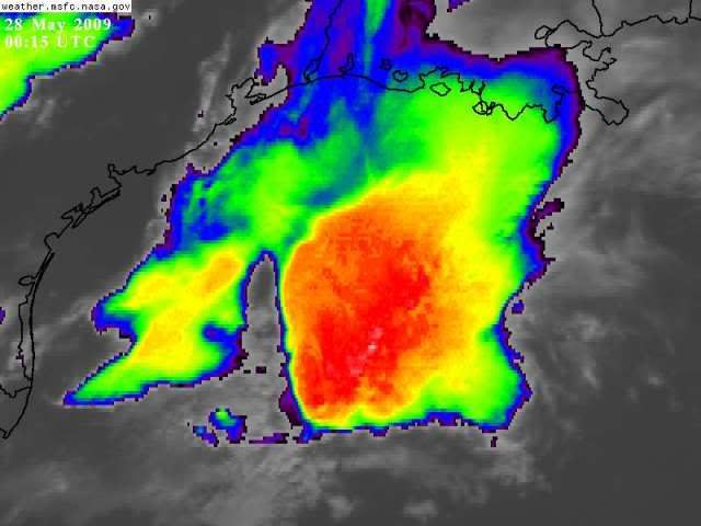
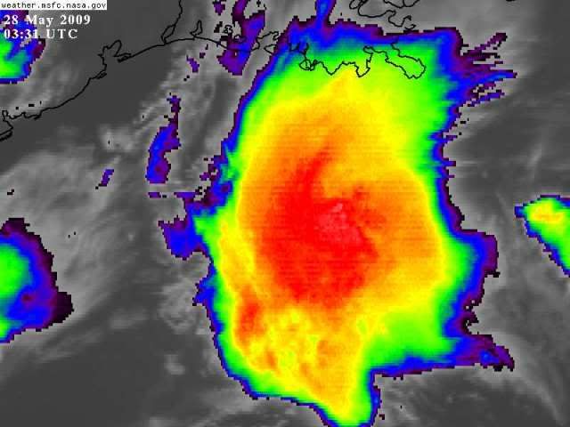
Discussions snippets:

NWS Miami:

THE GFS SEEMS TO BE
SUFFERING FROM CONVECTIVE FEEDBACK WITH THIS STRONG SOUTHEAST U.S.
TROUGH AS IT CONTINUES TO SPIN UP SURFACE FEATURES. ONE SUCH
FEATURE IS THAT SEVERAL WEAK SHORT WAVES HAVE BEEN ROTATING
THROUGH THE BASE OF THE TROUGH ENHANCING SOME OF OUR CONVECTION.
IT SHOWS A STRONG SHORT WAVE MOVING ACROSS SOUTH FLORIDA ON FRIDAY
AND THEN SPINS UP A SURFACE LOW OVER THE EASTERN GULF OF MEXICO.
NEITHER THE NAM NOR THE ECMWF INDICATE THIS WAVE. SO FOR THE TIME
BEING, WILL GO WITH LIKELY POPS EASTERN HALF OF THE REGION BOTH
THIS AFTERNOON AND AGAIN ON THURSDAY WITH SCATTERED POPS ON FRIDAY
UNTIL WE GET A BETTER FEEL WHETHER OR NOT ANY SHORT WAVE WILL HAVE
AN INFLUENCE. ONE THING IS FOR CERTAIN, IF THE GFS IS SEEING
SOMETHING THE OTHER MODELS ARE NOT, IT COULD BE A VERY ACTIVE
CONVECTIVE DAY ON FRIDAY SO THIS WILL BE WATCHED CLOSELY FOR SURE


http://forecast.weather.gov/product.php ... glossary=1

NWS Tampa:

GFS CONTINUES TO SHOW CONV FEEDBACK PROBLEMS BRINGING A CLOSED LOW
OVER WESTERN FL FRIDAY AFTERNOON. FOR NOW WILL FOLLOW PREVIOUS
FORECAST PHILOSOPHY AND LOAD GFS FOR WED AND THU THEN POPULATING
WINDS WITH NAM ON FRIDAY. NAM WINDS LOOK MORE REASONABLE WITH THE
RIDGE POSITIONING ITSELF ACROSS SOUTHERN FL ON FRIDAY.

http://www.srh.noaa.gov/tbw/getprodvers ... at=pretty;

NWS Melbourne:

THU-SAT...CONVECTIVE FEEDBACK APPARENT IN THIS PORTION OF THE
FORECAST. BROAD TROUGH OVER THE SOUTHEAST KEEPS SURFACE RIDGE
SUPPRESSED TO THE SOUTHEAST RESULTING IN A PERSISTENT SOUTHWEST
FLOW WHILE SLOWLY PUSHING A SURFACE TROUGH ACROSS THE SOUTHEAST
CLEARING CENTRAL FLORIDA SAT NIGHT.

http://www.srh.noaa.gov/productview.php ... MLB&max=10

00Z GFS 60 Hours:
Image
Last edited by gatorcane on Tue Jun 02, 2009 11:19 am, edited 3 times in total.
0 likes   

Ed Mahmoud

Re: GFS Develops a Closed Low in the GOM This Week

#2 Postby Ed Mahmoud » Wed May 27, 2009 9:21 am

Even the GFS low is pretty unspectacular.
0 likes   

meteorologyman
Category 2
Category 2
Posts: 541
Joined: Wed Mar 15, 2006 6:48 pm
Location: Florida, Kissimmee/St.CLoud

Re: GFS Develops a Closed Low in the GOM This Week

#3 Postby meteorologyman » Wed May 27, 2009 10:21 am

From GFS model it forecasted the storm to develop over sout texas then enter into the Gulf, then it becomes a closed low and makes lanfall at Florida if I am not mistaken on this infrared satellite. the storm over texas now is the one that "bears" watching.
http://www.ssd.noaa.gov/goes/east/tatl/loop-avn.html
0 likes   

meteorologyman
Category 2
Category 2
Posts: 541
Joined: Wed Mar 15, 2006 6:48 pm
Location: Florida, Kissimmee/St.CLoud

#4 Postby meteorologyman » Wed May 27, 2009 10:33 am

0 likes   

User avatar
srainhoutx
S2K Supporter
S2K Supporter
Posts: 6919
Age: 67
Joined: Sun Jan 14, 2007 11:34 am
Location: Haywood County, NC
Contact:

Re: GFS Develops a Closed Low in the GOM This Week

#5 Postby srainhoutx » Wed May 27, 2009 10:36 am

Another frontal boundry trough issue for late May. Would appear more rain for FL and parts of the SE.
0 likes   

User avatar
tailgater
S2K Supporter
S2K Supporter
Posts: 3339
Joined: Sun Jul 11, 2004 9:13 pm
Location: St. Amant La.

Re: GFS Develops a Closed Low in the GOM This Week

#6 Postby tailgater » Wed May 27, 2009 10:57 am

http://radar.weather.gov/radar.php?prod ... x&loop=yes
[img]http://radar.weather.gov/radar.php?product=N0V&rid=hgx&loop=yes[/img

I wouldn't won't be out there in that!
0 likes   

User avatar
gatorcane
S2K Supporter
S2K Supporter
Posts: 23689
Age: 47
Joined: Sun Mar 13, 2005 3:54 pm
Location: Boca Raton, FL

Re: GFS Develops a Closed Low in the GOM This Week

#7 Postby gatorcane » Wed May 27, 2009 11:00 am

meteorologyman wrote:From GFS model it forecasted the storm to develop over sout texas then enter into the Gulf, then it becomes a closed low and makes lanfall at Florida if I am not mistaken on this infrared satellite. the storm over texas now is the one that "bears" watching.
http://www.ssd.noaa.gov/goes/east/tatl/loop-avn.html


That is exactly right.

Look at the convection blowing up over SE Texas now (it blew up rather quickly this morning, was basically not there a few hours ago). Watch for that to push offshore SE into the GOM and traverse east over the Central GOM. Then the GFS thinks it closes off.

It's a bit far-fetched but who knows we'll see. I'd say that rain chances for Fri.-Sat. for peninsula Florida will be above climo.

Image

We should note the 12Z GFS just in does not develop a closed feature but instead pushes a concentrated area of convection more south now, through the FL straits and northern Cuba..

Image
0 likes   

meteorologyman
Category 2
Category 2
Posts: 541
Joined: Wed Mar 15, 2006 6:48 pm
Location: Florida, Kissimmee/St.CLoud

Re: GFS Develops a Closed Low in the GOM This Week

#8 Postby meteorologyman » Wed May 27, 2009 11:52 am

Switching subjects here a little whats is up with the storm in the EPAC and what is the status and heading of it. from image :uarrow:
0 likes   

Ed Mahmoud

Re: GFS Develops a Closed Low in the GOM This Week

#9 Postby Ed Mahmoud » Wed May 27, 2009 12:56 pm

meteorologyman wrote:Switching subjects here a little whats is up with the storm in the EPAC and what is the status and heading of it. from image :uarrow:


Seemed thread worthy...


Models not super-enthusiastic, but do close off week surface low pressure in the East Pac next 5 to 7 days from vorticity starting in this general area.
0 likes   

User avatar
hurricanetrack
HurricaneTrack.com
HurricaneTrack.com
Posts: 1781
Joined: Tue Dec 02, 2003 10:46 pm
Location: Wilmington, NC
Contact:

#10 Postby hurricanetrack » Wed May 27, 2009 2:17 pm

That is a heck of a complex of t-storms. Corpus is being rocked at the moment. Offshore, I bet the oil rigs are in the thick of it. Amazing weather these last few weeks.
0 likes   

floridasun78
Category 5
Category 5
Posts: 3755
Joined: Sun May 17, 2009 10:16 pm
Location: miami fl

#11 Postby floridasun78 » Wed May 27, 2009 2:30 pm

we need to see if that what gfs forecast or area of storm that form doing heating of day after move over water it disapear
0 likes   

User avatar
gatorcane
S2K Supporter
S2K Supporter
Posts: 23689
Age: 47
Joined: Sun Mar 13, 2005 3:54 pm
Location: Boca Raton, FL

#12 Postby gatorcane » Wed May 27, 2009 3:12 pm

Image
0 likes   

floridasun78
Category 5
Category 5
Posts: 3755
Joined: Sun May 17, 2009 10:16 pm
Location: miami fl

#13 Postby floridasun78 » Wed May 27, 2009 3:38 pm

here what miami weather office say about gfs this afternoon FOR THE WEEKEND...HAVE DISCOUNTED THE GFS AS THE LATEST 12Z RUN
(ALONG WITH PREVIOUS RUNS) HAVE BEEN SUFFERING FROM A SEVERE CASE
OF CONVECTIVE FEEDBACK AND SO IS UNRELIABLE. ECWMF LOOKS MORE
REASONABLE...AND HAS BEEN MORE CONSISTENT. THIS MODEL SHOWS A
POTENTIALLY VERY ACTIVE SATURDAY AS A LARGE AMPLITUDE TROUGH MOVES
ACROSS THE AREA. HAVE INCREASED POPS SLIGHTLY ALONG THE ATLANTIC
COAST FOR SATURDAY. IF THE ECWMF VERIFIES...THESE POPS ARE STILL
WAY TOO LOW. BUT GIVEN UNCERTAINTIES FOR THIS WEEKEND...DID NOT
MAKE SIGNIFICANT CHANGES AND WE CAN REFINE THIS DOWN THE ROAD.

http://forecast.weather.gov/product.php ... glossary=1
0 likes   

meteorologyman
Category 2
Category 2
Posts: 541
Joined: Wed Mar 15, 2006 6:48 pm
Location: Florida, Kissimmee/St.CLoud

Re: GFS Develops a Closed Low in the GOM This Week

#14 Postby meteorologyman » Wed May 27, 2009 4:14 pm

Ed Mahmoud wrote:
meteorologyman wrote:Switching subjects here a little whats is up with the storm in the EPAC and what is the status and heading of it. from image :uarrow:


Seemed thread worthy...


Models not super-enthusiastic, but do close off week surface low pressure in the East Pac next 5 to 7 days from vorticity starting in this general area.


Thank you Ed Mahmoud I had trouble finding Pacific weather satellites so I did not make a new thread since I had no data to give or to support
0 likes   

Jagno
Category 3
Category 3
Posts: 825
Joined: Tue Sep 07, 2004 10:40 pm
Location: SW Louisiana

Re: GFS Develops a Closed Low in the GOM This Week

#15 Postby Jagno » Wed May 27, 2009 5:55 pm

We will be leaving SW Louisiana(at the Texas border) Saturday morning early and traveling the coast to Orlando, Florida with a large camper, a Wells Cargo trailer, 2 trucks, a Harley and another car to move my son there for college. I pray this weather clears out before we get there. It's a 14 + hour drive and this is NOT what I wanted to face. Thanks for keeping us updated. The information is always appreciated.
0 likes   

User avatar
AdamFirst
S2K Supporter
S2K Supporter
Posts: 2491
Age: 36
Joined: Thu Aug 14, 2008 10:54 am
Location: Port Saint Lucie, FL

#16 Postby AdamFirst » Wed May 27, 2009 6:02 pm

Bring on the rain.

More! More! More!
0 likes   

User avatar
tailgater
S2K Supporter
S2K Supporter
Posts: 3339
Joined: Sun Jul 11, 2004 9:13 pm
Location: St. Amant La.

Re: GFS Develops a Closed Low in the GOM This Week

#17 Postby tailgater » Wed May 27, 2009 6:08 pm

fast moving complex, nothing at the suface as for as low developing but none the less impressive.
Image
0 likes   

User avatar
HURAKAN
Professional-Met
Professional-Met
Posts: 46086
Age: 38
Joined: Thu May 20, 2004 4:34 pm
Location: Key West, FL
Contact:

#18 Postby HURAKAN » Wed May 27, 2009 7:43 pm

Image

Continues to look powerful. Lets see how long it lasts.
0 likes   

Ed Mahmoud

Re: GFS Develops a Closed Low in the GOM This Week

#19 Postby Ed Mahmoud » Wed May 27, 2009 9:40 pm

Thirty to fifty knots of wind pushing it along seems to have given it a very sharp back edge to the convection.

Image

Image
0 likes   

User avatar
HURAKAN
Professional-Met
Professional-Met
Posts: 46086
Age: 38
Joined: Thu May 20, 2004 4:34 pm
Location: Key West, FL
Contact:

#20 Postby HURAKAN » Wed May 27, 2009 10:44 pm

Image
0 likes   


Return to “Talkin' Tropics”

Who is online

Users browsing this forum: No registered users and 95 guests