
Personal Disclaimer: For all official information, please view the National Hurricane Center at http://www.nhc.noaa.gov/ . For local statements and evacuation information, please go to http://www.srh.noaa.gov/ and click on the appropriate location for your hometown.
Graphics Disclaimer: The graphic here is for visualization purposes only and is NOT endorsed by S2K, NWS, NHC, or NOAA.
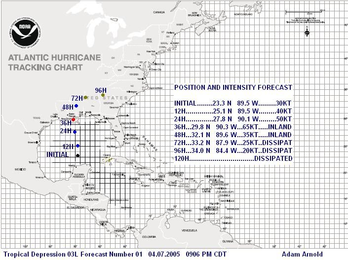
SUN 04.07.2005 0924 PM CDT
03L.NONAME Discussion
03L briefly became disorganized earlier today, but recent satellite photographs have showed that it may be getting better organized. Current movement is towards the NNW, which should put it on the coast sometime in the 36 HR range. It appears that the center is trying to get vertically stacked, but is not having much luck. We need more information from the recon to be able to tell for sure. I am concerned that it could really start to get its act together overnight tonight during the diurnal maximum, but we will have to see. My forecast on the graphic is conservative and at a steady intensification pace, however, if 03L gets better organized overnight tonight, there is a pocket of warmer waters that it may be traversing, and it could be stronger than forecasted here. All persons along the Northern Gulf Coast should continue to monitor this system.
04L.NONAME Brief
I will be brief until I gather more information and 03L is less of a threat, in which then I will be creating forecast graphics for 04L. 04L has consistently been getting better organized throughout the day to warrant the classification at 11 PM. Right now, I expect 04L to maintain a quick pace to the WNW, and possibly slow down as it approaches the Hispanola region. It may pass over Eastern Cuba as it traverses in a WNW/NW direction towards SE FL. Right now, conditions are favorable for a steady development of the system and I would not be surprised to see it become a hurricane in 72 HR. More information and in-depth discussions will be given in later discussions throughout the week.
*END

