Quick Diagram I drew up in Photoshop....
http://img514.imageshack.us/my.php?imag ... te1cu6.jpg
This image shows the following:
- Light Gray Cirle: Claudette's Eye
- Opaque Gray Circle: Claudette's Eyewall
- Yellow Circle: Downtown Houston
I made this to illustrate just how vulnerable Houston is to extreme wind damage from a high end category hurricane...despite some claims ive heard that Houston is pretty safe from destruction from a Category 4-5 hurricane. I disagree, and this diagram shows why. Notice that the actual hurricane itself has just made landfall in this diagram, and already the northern eyewall is approaching downtown houston, while the southern eyewall is still battering extreme western galveston. If this hurricane were strengthening like Claudette, and it was a high end 4 or low end 5 (lets say 155-160 mph), Houston would no doubt see either high-end 2 or lower end major hurricane conditions imo (somewhere between 100-120, depending on speed of movement). Anything higher than 155-160 and Houston would be really devastated (Although i dont think a high-end cat 5 could strike Houston due to land interaction/dry air). I know most mets would say (well it will weaken over land and lower 2-3 categories), but I offer this quote as my disagreement:
"As slow as Claudette was to strengthen, it was also slow to dissipate over land. Inland hurricane warnings were issued for several counties away from the coastline and winds gusted to 83 mph at Victoria Regional Airport.[2] It maintained tropical storm intensity for over 24 hours after landfall, a rarity for such a weak storm; most tropical systems weaken rapidly after landfall, as they are separated from the warm waters that power them. The storm finally lost its low-level circulation early on July 17 over Chihuahua, although its rainfall and upper-level circulation continued into the Pacific Ocean."
If Claudette could warrant inland hurricane warnings that far inland, then imagine what a High-end 4 or low-end 5 could do?
More Evidence:
- Victoria, TX recorded sustained winds of 55-60 mph with gusts to 80+. Mind you this is from an intensifying 85-90 mph storm.
- Victoria is located about 36-40 miles from the shore (Port O'Connor, landfall location).
- Houston is also located about 36-40 miles from Galveston (perhaps a shade more, but not much).
Same situation (movement, intesification). Lets double Claudette's windspeed. Instead of 85-90, lets make it 170-180 (very unlikely, but possible)
- Victoria would have recorded 110-120 mph sustained winds, with gusts to 160 mph. Thats major hurricane conditions.
*One more thing to note, Claudette did not strike the Texas coast in perpendicular fashion, so it actually interacted with land more than say a Katrina would have (which hit MS/LA straight on). If you look at the loop, Claudette approached the Texas coast from the west, and continued west towards port O'Connor. In fact, Claudette's northern eyewall struck East Matagorda Bay first, barely missing Freeport....so Claudette's eyewall began interacting with land about 2-3 hours before it made landfall.
If the track of Claudette had been perpendicular to the coast Victoria sits on, Victoria probably would have seen higher winds.
So whats my point? Evacuations for a hurricane of this magnitude is necesarry for everyone south of I-10 imo, because everybody south of I-10 would definitely see major hurricane conditions from a storm like the one im proposing, given it hit the coastline at the perfect angle (much like Katrina). Anyone agree/disagree?
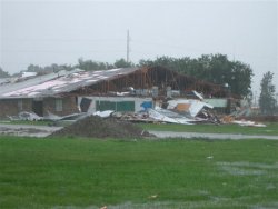
Also, imo this is the best idea of what damage to a high-rise would look like under major hurricane conditions.

I know comparing a tornado and a hurricane isn't the best thing to do, but winds between a major and an f-2 are comparable, especially for high-rises (since the wind is higher the farther up you go). Probably not a totally accurate depiction, or maybe it is, I dunno, but I would say this picture shows what damage could potentially look like in downtown Houston if storm like the one I proposed ever hit.


