
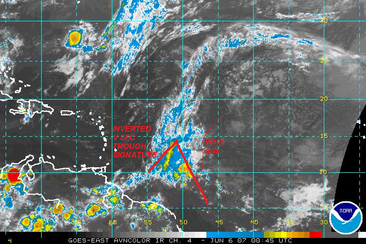
I just decided to offer some thoughts on the developing situation with the wave east of the Windward Islands. Although I don't believe that we will observe development over the shorter term, it is possible that the upcoming pattern could play a role if the wave axis survives as it moves into the western Caribbean Sea. I'm not jumping to conclusions, but I believe that the potential for slow development may exist over the next several days.
While the wave axis is visible, I do not expect significant development. Sfc covergence is weak, and mid-level shear is significant. In addition, the wave lacks a defined low-level circulation, and I have not noticed any signs of a sfc low. See the latest visible loop. Although the mid-level environment is more favorable in the eastern Caribbean, there is a significant convective cap in place across that region. In addition, note the mid-level dry air. As the wave is weak, the Windward Islands graveyard may claim another victim.
There is caveat. If the wave axis survives this journey, the prospects may become more interesting within the western Caribbean. A sfc trough (and sfc low) has been established over the Yucatan Peninsula, northern BOC, and southern GOM. As the Southeast trough moves away from the region, ridging may build northward over the course of the next several days. If I am correct, this might reduce shear and provide a better environment for slow development. The chances may increase as the wave axis interacts with the low pressure environment south of Jamaica and Cuba. The Miami NWS mentions the the ridge in their discussion.
.DISCUSSION...SURFACE HIGH PRESSURE RIDGE OVER THE FLORIDA STRAITS
WILL CONTINUE TO MOVE NORTHWARD ONTO SOUTH FLORIDA BY WEDNESDAY.
MOISTURE IS MOVING NORTH WITH THE RIDGE BUT NOT AS FAST AS EARLIER
EXPECTED. GPS WATER VAPOR IS RANGING FROM 1.85" OVER THE KEYS TO 1.7"
OVER MIAMI TO 1.4" NEAR THE LAKE. LOWERED THE POPS A TAD FOR THE
REST OF TODAY. FOR WEDNESDAY, THE GFS40 IS GOING CRAZY WITH THE
POPS WHICH SEEMS TO BE FROM CONVECTIVE FEEDBACK SO LEANED MORE TO THE
NAM/MET DATA. BUT A SHORT WAVE WILL APPROACH THE CWA FROM THE WEST
THROUGH WEDNESDAY. ON THURSDAY, WITH INCREASING EASTERLY FLOW
WITH THE RIDGE MOVING NORTH, THE HIGHEST POPS WILL BE FOCUSED OVER
THE INTERIOR AND WEST. POPS WILL DECREASE STEADILY THROUGH SUNDAY
TO SLGT CHC AS DRIER AIR FINALLY WORKS IN. POPS WILL INCREASE
AGAIN TO CHC FOR MONDAY AND TUESDAY. HUMIDITIES WILL BE HIGHER
THAN THEY HAD BEEN IN PREVIOUS WEEKS.
In addition, the GFS and Euro indicates that we may observe the development of lower pressures over the western Caribbean Sea and southern Gulf of Mexico. The reliable Euro ensembles have been providing some hints of a favorable environment. As I can't find the Euro link, I'll post the latest GFS data.
http://www.nco.ncep.noaa.gov/pmb/nwprod ... _078.shtml
Note the higher sfc pressures over the region. This provides an easterly flow regime and it aids the development of low-level systems. This could reduce low-level shear. What do you think?


Note that the ingredients are in their place. We have low pressures, an adjacent sfc trough, and an upcoming pattern that may favor development. If the wave axis survives into the western Caribbean, we may observe an interesting scenario over the next several days.


