EPAC: KRISTY - Remnants - Discussion

Moderator: S2k Moderators

Message
Author
User avatar
cycloneye
Admin
Admin
Posts: 143862
Age: 68
Joined: Thu Oct 10, 2002 10:54 am
Location: San Juan, Puerto Rico

EPAC: KRISTY - Remnants - Discussion

#1 Postby cycloneye » Sun Oct 20, 2024 7:44 pm

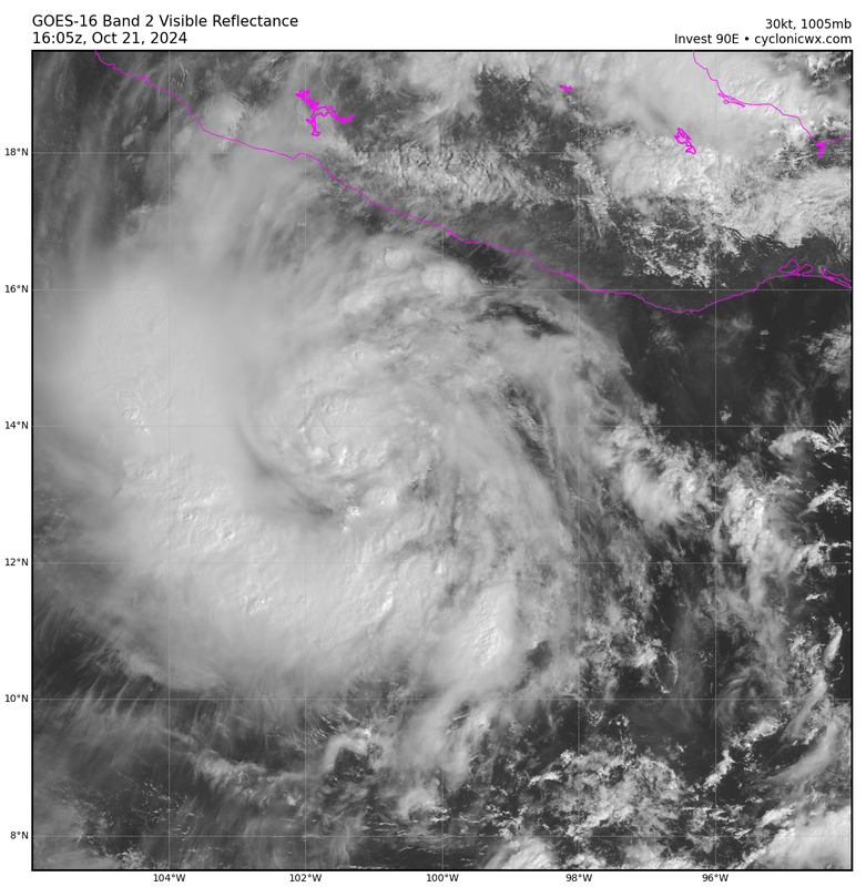
EP, 90, 2024102100, , BEST, 0, 150N, 972W, 25, 1007, DB, 34, NEQ, 0, 0, 0, 0, 1009, 100, 50, 0, 0, E, 0, , 0, 0, INVEST, S, 0, , 0, 0, 0, 0, genesis-num, 032, SPAWNINVEST, ep752024 to ep902024,


https://ftp.nhc.noaa.gov/atcf/btk/bep902024.dat

Image
0 likes   
Visit the Caribbean-Central America Weather Thread where you can find at first post web cams,radars
and observations from Caribbean basin members Click Here

TallyTracker
Category 2
Category 2
Posts: 719
Joined: Thu Oct 11, 2018 2:46 pm

Re: EPAC: INVEST 90E - Discussion

#2 Postby TallyTracker » Sun Oct 20, 2024 8:02 pm

Is this from the remnants of Nadine or a completely separate system?
0 likes   
Fran '96, Georges '98, Gordon '00, Gabrielle '01, Charley '04, Frances '04, Jeanne '04, Barry '07, Fay '08, Debby '12, Matthew '16, Emily '17, Irma '17, Michael ‘18, Elsa ‘21, Fred ‘21, Mindy ‘21, Nicole ‘22, Idalia ‘23, Debby ‘24, Helene ‘24

User avatar
cycloneye
Admin
Admin
Posts: 143862
Age: 68
Joined: Thu Oct 10, 2002 10:54 am
Location: San Juan, Puerto Rico

Re: EPAC: INVEST 90E - Discussion

#3 Postby cycloneye » Sun Oct 20, 2024 8:43 pm

TallyTracker wrote:Is this from the remnants of Nadine or a completely separate system?


The TWO did not mention the remnants so it will have the Kristy name.
0 likes   
Visit the Caribbean-Central America Weather Thread where you can find at first post web cams,radars
and observations from Caribbean basin members Click Here

User avatar
cycloneye
Admin
Admin
Posts: 143862
Age: 68
Joined: Thu Oct 10, 2002 10:54 am
Location: San Juan, Puerto Rico

Re: EPAC: INVEST 90E - Discussion

#4 Postby cycloneye » Sun Oct 20, 2024 9:38 pm

Is not wasting time.

Image
0 likes   
Visit the Caribbean-Central America Weather Thread where you can find at first post web cams,radars
and observations from Caribbean basin members Click Here

User avatar
Travorum
Category 1
Category 1
Posts: 406
Joined: Tue Sep 05, 2023 9:36 am
Location: Dunedin, FL

Re: EPAC: INVEST 90E - Discussion

#5 Postby Travorum » Mon Oct 21, 2024 12:17 am

Microwave pass from 2 hours ago, with the rough center (linearly interpolated from 0z BT) marked by the X:

ImageImage

The strongest convection is in that band off to the west, but the structure under the hood is definitely there.
1 likes   

User avatar
cycloneye
Admin
Admin
Posts: 143862
Age: 68
Joined: Thu Oct 10, 2002 10:54 am
Location: San Juan, Puerto Rico

Re: EPAC: INVEST 90E - Discussion

#6 Postby cycloneye » Mon Oct 21, 2024 4:42 am

South of Southwestern Mexico (EP90):
Showers and thunderstorms associated with a trough of low pressure
located more than 100 miles offshore the coast of southern Mexico
have become a little better organized over the past several hours.
Environmental conditions are favorable for additional development,
and a tropical depression or storm is expected to form within the
next day or so while the system moves westward at around 15 mph away
from the coast of Mexico. Additional information on this system,
including gale warnings, can be found in High Seas Forecasts issued
by the National Weather Service.
* Formation chance through 48 hours...high...90 percent.
* Formation chance through 7 days...high...90 percent.
0 likes   
Visit the Caribbean-Central America Weather Thread where you can find at first post web cams,radars
and observations from Caribbean basin members Click Here

User avatar
cycloneye
Admin
Admin
Posts: 143862
Age: 68
Joined: Thu Oct 10, 2002 10:54 am
Location: San Juan, Puerto Rico

Re: EPAC: INVEST 90E - Discussion

#7 Postby cycloneye » Mon Oct 21, 2024 6:41 am

Tropical Weather Outlook
NWS National Hurricane Center Miami FL
500 AM PDT Mon Oct 21 2024

For the eastern North Pacific...east of 140 degrees west longitude:

South of Southwestern Mexico (EP90):
Showers and thunderstorms continue to show signs of organization
with a trough of low pressure located a few hundred miles offshore
of the coast of southern Mexico. Environmental conditions are
favorable for additional development, and a tropical depression or
storm is expected to form within the next day or so while the system
moves westward at around 15 mph away from the coast of Mexico.
Additional information on this system, including gale warnings, can
be found in High Seas Forecasts issued by the National Weather
Service.
* Formation chance through 48 hours...high...90 percent.
* Formation chance through 7 days...high...90 percent.

&&
High Seas Forecasts issued by the National Weather Service
can be found under AWIPS header NFDHSFEPI, WMO header FZPN02
KWBC, and on the web at ocean.weather.gov/shtml/NFDHSFEPI.php

$$
Forecaster Papin/Delgado
0 likes   
Visit the Caribbean-Central America Weather Thread where you can find at first post web cams,radars
and observations from Caribbean basin members Click Here

User avatar
Kingarabian
S2K Supporter
S2K Supporter
Posts: 15827
Joined: Sat Aug 08, 2009 3:06 am
Location: Honolulu, Hawaii

Re: EPAC: INVEST 90E - Discussion

#8 Postby Kingarabian » Mon Oct 21, 2024 9:07 am

This is a TC. Not sure about the whole 90/90 thing for 12 hrs straight and continuing.
1 likes   
RIP Kobe Bryant

User avatar
Kingarabian
S2K Supporter
S2K Supporter
Posts: 15827
Joined: Sat Aug 08, 2009 3:06 am
Location: Honolulu, Hawaii

Re: EPAC: INVEST 90E - Discussion

#9 Postby Kingarabian » Mon Oct 21, 2024 11:19 am

Image
Large feeder band and a developing CDO.

How can they look at this say it's not even a TD? Dvorak at this stage is pretty subjective but this is at least a T2.0 if not a T2.5(TS).
0 likes   
RIP Kobe Bryant

User avatar
Hurricane2022
Category 5
Category 5
Posts: 1496
Joined: Tue Aug 23, 2022 11:38 pm
Location: Araçatuba, Brazil

Re: EPAC: INVEST 90E - Discussion

#10 Postby Hurricane2022 » Mon Oct 21, 2024 11:31 am

Hot take: I think this will become a powerful C5 (unofficially of course :lol:)
0 likes   
Sorry for the bad English sometimes...!
For reliable and detailed information for any meteorological phenomenon, please consult the National Hurricane Center, Joint Typhoon Warning Center , or your local Meteo Center.

--------

Una cvm Christo, pro Christo, et in Christo. Sit nomen Domini benedictvm.

zzzh
Category 3
Category 3
Posts: 833
Joined: Thu Sep 02, 2021 1:13 pm

Re: EPAC: INVEST 90E - Discussion

#11 Postby zzzh » Mon Oct 21, 2024 12:31 pm

Kingarabian wrote:https://i.postimg.cc/1XMVpSRJ/goes16-90-E-band02-202410211605.png
Large feeder band and a developing CDO.

How can they look at this say it's not even a TD? Dvorak at this stage is pretty subjective but this is at least a T2.0 if not a T2.5(TS).

Agreed with this being at least a TD, but I don't think that's a CDO.
1 likes   

User avatar
cycloneye
Admin
Admin
Posts: 143862
Age: 68
Joined: Thu Oct 10, 2002 10:54 am
Location: San Juan, Puerto Rico

Re: EPAC: INVEST 90E - Discussion

#12 Postby cycloneye » Mon Oct 21, 2024 12:57 pm

TD or TS at 2 PM PDT.


South of Southwestern Mexico (EP90):
Recent satellite-derived wind data indicates that a well-defined
surface circulation is forming with an area of low pressure located
a few hundred miles offshore of the coast of southern Mexico.
Shower and thunderstorm activity associated with this system also
continues to become better organized. If these trends continue,
advisories will likely be initiated on this system as a tropical
depression or storm at 2 PM PDT. This system is forecast to move
westward at around 15 mph away from the coast of Mexico. Additional
information on this system, including storm warnings, can be found
in High Seas Forecasts issued by the National Weather Service.
* Formation chance through 48 hours...high...near 100 percent.
* Formation chance through 7 days...high...near 100 percent.
[b]
[/b]
0 likes   
Visit the Caribbean-Central America Weather Thread where you can find at first post web cams,radars
and observations from Caribbean basin members Click Here

User avatar
Travorum
Category 1
Category 1
Posts: 406
Joined: Tue Sep 05, 2023 9:36 am
Location: Dunedin, FL

Re: EPAC: INVEST 90E - Discussion

#13 Postby Travorum » Mon Oct 21, 2024 3:43 pm

The ASCAT data in question, from about 16-17z. Would support a tropical storm in a few minutes.
ImageImage
0 likes   

User avatar
Travorum
Category 1
Category 1
Posts: 406
Joined: Tue Sep 05, 2023 9:36 am
Location: Dunedin, FL

Re: EPAC: INVEST 90E - Discussion

#14 Postby Travorum » Mon Oct 21, 2024 3:43 pm

Speak of the devil:
BULLETIN
Tropical Storm Kristy Advisory Number 1
NWS National Hurricane Center Miami FL EP122024
300 PM CST Mon Oct 21 2024

...TROPICAL STORM KRISTY FORMS WELL SOUTH OF MEXICO...


SUMMARY OF 300 PM CST...2100 UTC...INFORMATION
----------------------------------------------
LOCATION...13.5N 102.0W
ABOUT 275 MI...440 KM SSW OF ACAPULCO MEXICO
ABOUT 700 MI...1125 KM ESE OF SOCORRO ISLAND
MAXIMUM SUSTAINED WINDS...40 MPH...65 KM/H
PRESENT MOVEMENT...W OR 270 DEGREES AT 17 MPH...28 KM/H
MINIMUM CENTRAL PRESSURE...1005 MB...29.68 INCHES
1 likes   

MEANINGLESS_NUMBERS
Category 1
Category 1
Posts: 325
Joined: Mon Nov 02, 2020 1:43 pm

Re: EPAC: INVEST 90E - Discussion

#15 Postby MEANINGLESS_NUMBERS » Mon Oct 21, 2024 4:18 pm

cycloneye wrote:
TallyTracker wrote:Is this from the remnants of Nadine or a completely separate system?


The TWO did not mention the remnants so it will have the Kristy name.


One TOW did mention Nadine, but then the later ones dropped the mention.
1 likes   
Emily '87, Felix '95, Gert '99, Fabian '03, Humberto '19, Paulette '20, Teddy '20, Fiona '22, Lee '23, Ernesto '24

emeraldislenc
Category 2
Category 2
Posts: 558
Joined: Fri Aug 24, 2012 4:49 pm
Location: Emerald Isle NC

Re: EPAC: KRISTY - Tropical Storm - Discussion

#16 Postby emeraldislenc » Mon Oct 21, 2024 6:07 pm

Remnants of Nadine
Amazing it happened in Atlantic when the famous M storm crossed over
1 likes   

User avatar
Travorum
Category 1
Category 1
Posts: 406
Joined: Tue Sep 05, 2023 9:36 am
Location: Dunedin, FL

Re: EPAC: KRISTY - Tropical Storm - Discussion

#17 Postby Travorum » Mon Oct 21, 2024 6:23 pm

emeraldislenc wrote:Remnants of Nadine
Amazing it happened in Atlantic when the famous M storm crossed over


Crazy to think that had TD11-E and Nadine developed more/had their circulations remained intact over Mexico, we would have had a Kristy impacting Florida and a Milton out in the Pacific right now.
0 likes   

User avatar
AnnularCane
S2K Supporter
S2K Supporter
Posts: 2836
Joined: Thu Jun 08, 2006 9:18 am
Location: Wytheville, VA

Re: EPAC: KRISTY - Tropical Storm - Discussion

#18 Postby AnnularCane » Mon Oct 21, 2024 6:54 pm

Kristy looks a lot like Nadine. 8-)
0 likes   
"But it never rained rain. It never snowed snow. And it never blew just wind. It rained things like soup and juice. It snowed mashed potatoes and green peas. And sometimes the wind blew in storms of hamburgers." -- Judi Barrett, Cloudy with a Chance of Meatballs

User avatar
Yellow Evan
Professional-Met
Professional-Met
Posts: 16058
Age: 26
Joined: Fri Jul 15, 2011 12:48 pm
Location: Henderson, Nevada/Honolulu, HI
Contact:

Re: EPAC: KRISTY - Tropical Storm - Discussion

#19 Postby Yellow Evan » Mon Oct 21, 2024 7:22 pm

Upper environment supports a strong hurricane in 3-4 days, possibly the strongest of the season, before the subtropical jet shears it. Shades of Kenneth 11.
3 likes   

User avatar
cycloneye
Admin
Admin
Posts: 143862
Age: 68
Joined: Thu Oct 10, 2002 10:54 am
Location: San Juan, Puerto Rico

Re: EPAC: KRISTY - Tropical Storm - Discussion

#20 Postby cycloneye » Mon Oct 21, 2024 9:45 pm

Tropical Storm Kristy Discussion Number 2
NWS National Hurricane Center Miami FL EP122024
900 PM CST Mon Oct 21 2024

Kristy is becoming better organized this evening. Bursts of deep
convection are wrapping around the western semicircle of the
circulation with upper-level outflow also present in this region.
Subjective and objective Dvorak estimates range between 35 to 53 kt.
The initial intensity for this advisory is raised to 40 kt, closest
to the UW-CIMSS DMINT objective Dvorak estimate.

The tropical storm is heading westward at 270/14 kt. This general
motion should continue through Thursday while Kristy moves along the
southern side of a subtropical ridge. By Friday and Saturday, the
storm will reach a weakness in the ridge caused by a cutoff low
over the north Pacific and gradually turn west-northwestward to
northwestward. The latest track forecast is quite similar to the
previous forecast and lies near the various consensus aids.

The fragmented convection seen on satellite infrared imagery seems
to indicate that there is a dry air intrusion possibly slowing
Kristy's present organization. However, atmospheric and oceanic
conditions are quickly becoming more conducive for significant to
rapid intensification. Statistical guidance from SHIPS-RII is
showing a high chance (72 percent) of 25 kt of strengthening in 24
h. Therefore, the latest NHC intensity forecast now explicitly
forecasts this increase, making Kristy a hurricane on Tuesday and
nudging up the peak to 100 kt in 60 h. On Friday and Saturday, the
vertical wind shear is expected to increase and induce a weakening
trend. This intensity forecast lies in the middle of the guidance
envelope, between the HCCA and the previous prediction.


FORECAST POSITIONS AND MAX WINDS

INIT 22/0300Z 13.7N 103.3W 40 KT 45 MPH
12H 22/1200Z 13.9N 105.4W 50 KT 60 MPH
24H 23/0000Z 14.2N 108.5W 65 KT 75 MPH
36H 23/1200Z 14.2N 111.9W 80 KT 90 MPH
48H 24/0000Z 14.2N 115.4W 95 KT 110 MPH
60H 24/1200Z 14.1N 118.6W 100 KT 115 MPH
72H 25/0000Z 14.4N 121.6W 100 KT 115 MPH
96H 26/0000Z 16.4N 126.7W 90 KT 105 MPH
120H 27/0000Z 19.7N 131.0W 75 KT 85 MPH

$$
Forecaster Bucci
0 likes   
Visit the Caribbean-Central America Weather Thread where you can find at first post web cams,radars
and observations from Caribbean basin members Click Here


Return to “2024”

Who is online

Users browsing this forum: No registered users and 13 guests