
ATL: ERIN - Tropical Storm - Discussion
Moderators: hurricanetrack, S2k Moderators

The posts in this forum are NOT official forecasts and should not be used as such. They are just the opinion of the poster and may or may not be backed by sound meteorological data. They are NOT endorsed by any professional institution or STORM2K. For official information, please refer to products from the National Hurricane Center and National Weather Service.

-
Sciencerocks
- Category 5

- Posts: 9166
- Age: 39
- Joined: Thu Jul 06, 2017 1:51 am
-
cycloneye

- Admin

- Posts: 145867
- Age: 69
- Joined: Thu Oct 10, 2002 10:54 am
- Location: San Juan, Puerto Rico
Re: ATL: ERIN - Tropical Storm - Discussion
Beef Stew wrote:A recurve is definitely the most likely outcome here, but I won't feel reaching that conclusion for at least a few more days. Mid-August climo suggests that, while still less likely than a recurve, the sub-seasonal risk for a US east coast landfall from an MDR storm remains comparatively elevated. Until Erin completes her forecasted WSW motion and we have a better idea of the position and strength of the ridge over the North Atlantic, we won't be able to say where this storm ends up definitively. The synoptic pattern surrounding Florence was also favoring a recurve... until the building ridge turned out to be far stronger than originally modeled.
And even if the likely recurve does happen, I think it's important to remember that recurve ≠ fish storm. An impact to Bermuda or Atlantic Canada are both well within the range of realistic outcomes.
Moved your post from the models thread to here.
2 likes
Visit the Caribbean-Central America Weather Thread where you can find at first post web cams,radars
and observations from Caribbean basin members Click Here
and observations from Caribbean basin members Click Here


Re: ATL: ERIN - Tropical Storm - Discussion
cycloneye wrote:Beef Stew wrote:A recurve is definitely the most likely outcome here, but I won't feel reaching that conclusion for at least a few more days. Mid-August climo suggests that, while still less likely than a recurve, the sub-seasonal risk for a US east coast landfall from an MDR storm remains comparatively elevated. Until Erin completes her forecasted WSW motion and we have a better idea of the position and strength of the ridge over the North Atlantic, we won't be able to say where this storm ends up definitively. The synoptic pattern surrounding Florence was also favoring a recurve... until the building ridge turned out to be far stronger than originally modeled.
And even if the likely recurve does happen, I think it's important to remember that recurve ≠ fish storm. An impact to Bermuda or Atlantic Canada are both well within the range of realistic outcomes.
Moved your post from the models thread to here.
Thanks! Yeah, it's more relevant here than in the models thread.
2 likes
-
Cachondo23
- Tropical Depression

- Posts: 83
- Joined: Wed May 25, 2022 5:56 am
Re: ATL: INVEST 97L - Discussion
Hurricane2022 wrote:Unfortunately, Cape Verde has reported damages and 5 deaths from the newly-upgraded Tropical Storm ERIN.
https://x.com/dtudo1poucocv/status/1954862958984540427
Who knows if PTC advisories could have avoided this situation. At least have them prepared that squally weather was in their geographical area.
2 likes
-
Hurricane2022

- Category 5
- Posts: 1596
- Joined: Tue Aug 23, 2022 11:38 pm
- Location: Araçatuba, Brazil
Re: ATL: ERIN - Tropical Storm - Discussion
2 likes
Sorry for the bad English sometimes...!
For reliable and detailed information for any meteorological phenomenon, please consult the National Hurricane Center, Joint Typhoon Warning Center , or your local Meteo Center.
--------
Una cvm Christo, pro Christo, et in Christo. Sit nomen Domini benedictvm.
For reliable and detailed information for any meteorological phenomenon, please consult the National Hurricane Center, Joint Typhoon Warning Center , or your local Meteo Center.
--------
Una cvm Christo, pro Christo, et in Christo. Sit nomen Domini benedictvm.
-
cycloneye
- Admin
- Posts: 145867
- Age: 69
- Joined: Thu Oct 10, 2002 10:54 am
- Location: San Juan, Puerto Rico
Re: ATL: ERIN - Tropical Storm - Discussion
18z Best Track:

AL, 05, 2025081118, , BEST, 0, 174N, 293W, 40, 1004, TS
0 likes
Visit the Caribbean-Central America Weather Thread where you can find at first post web cams,radars
and observations from Caribbean basin members Click Here
and observations from Caribbean basin members Click Here
-
eastcoastFL

- Category 5
- Posts: 3907
- Age: 43
- Joined: Thu Apr 12, 2007 12:29 pm
- Location: Palm City, FL
Re: ATL: INVEST 97L - Discussion
Cachondo23 wrote:Hurricane2022 wrote:Unfortunately, Cape Verde has reported damages and 5 deaths from the newly-upgraded Tropical Storm ERIN.
https://x.com/dtudo1poucocv/status/1954862958984540427
Who knows if PTC advisories could have avoided this situation. At least have them prepared that squally weather was in their geographical area.
That would've been a decision for the local authorities. They apparently didn't think it was necessary
0 likes
Personal Forecast Disclaimer:
The posts in this forum are NOT official forecast and should not be used as such. They are just the opinion of the poster and may or may not be backed by sound meteorological data. They are NOT endorsed by any professional institution or storm2k.org. For official information, please refer to the NHC and NWS products.
The posts in this forum are NOT official forecast and should not be used as such. They are just the opinion of the poster and may or may not be backed by sound meteorological data. They are NOT endorsed by any professional institution or storm2k.org. For official information, please refer to the NHC and NWS products.
-
wxman57

- Moderator-Pro Met

- Posts: 22991
- Age: 67
- Joined: Sat Jun 21, 2003 8:06 pm
- Location: Houston, TX (southwest)
Re: ATL: ERIN - Tropical Storm - Discussion
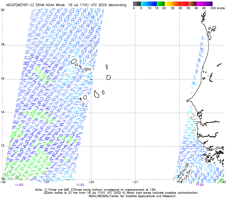
ASCAT-C descending pass from 11Z did not indicate an LLC or 35kt winds. This may still be an open wave. It's fighting another round of SAL coming in from the east now. May not really get going until it passes north of the eastern Caribbean on Saturday. 12Z EC shifted about 60 miles east, passing closer to Bermuda next Monday evening.
0 likes
-
Sciencerocks
- Category 5
- Posts: 9166
- Age: 39
- Joined: Thu Jul 06, 2017 1:51 am

-
JetFuel_SE

- Category 1

- Posts: 284
- Age: 25
- Joined: Thu Apr 30, 2020 3:57 pm
Re: ATL: ERIN - Tropical Storm - Discussion
wxman57 wrote:ASCAT-C descending pass from 11Z did not indicate an LLC or 35kt winds. This may still be an open wave. It's fighting another round of SAL coming in from the east now. May not really get going until it passes north of the eastern Caribbean on Saturday. 12Z EC shifted about 60 miles east, passing closer to Bermuda next Monday evening.
would you be kind enough to show said ASCAT pass?
0 likes


Re: ATL: ERIN - Tropical Storm - Discussion
wxman57 wrote:ASCAT-C descending pass from 11Z did not indicate an LLC or 35kt winds. This may still be an open wave. It's fighting another round of SAL coming in from the east now. May not really get going until it passes north of the eastern Caribbean on Saturday. 12Z EC shifted about 60 miles east, passing closer to Bermuda next Monday evening.
The official forecast and model intensity guidance suggests otherwise, and there was plenty of support for a closed circulation last night as assessed by the NHC. It's true that satellite intensity estimates have dropped off since last night, but scatterometer data from the same timeframe seems to indicate that there were winds of 35~40 kts and a closed albeit elongated circulation, at least at that time:
We also received scatterometer data at 1107 UTC
with a peak wind retrieval of 39 kt embedded in this convection,
with an ambiguity analysis suggesting the circulation is also
well defined, albeit still somewhat elongated on the eastern edge.
with a peak wind retrieval of 39 kt embedded in this convection,
with an ambiguity analysis suggesting the circulation is also
well defined, albeit still somewhat elongated on the eastern edge.
There's a lot of uncertainty in the forecast long-term but the support for for gradual intensification over the next 48 hours is strong, assuming the NHC's assesment of the 11z scatterometry was correct.
1 likes
-
Ian2401
- Category 1
- Posts: 315
- Joined: Thu Sep 14, 2017 5:55 pm
- Location: Tallahassee, Florida
- Contact:
Re: ATL: ERIN - Tropical Storm - Discussion
JetFuel_SE wrote:wxman57 wrote:ASCAT-C descending pass from 11Z did not indicate an LLC or 35kt winds. This may still be an open wave. It's fighting another round of SAL coming in from the east now. May not really get going until it passes north of the eastern Caribbean on Saturday. 12Z EC shifted about 60 miles east, passing closer to Bermuda next Monday evening.
would you be kind enough to show said ASCAT pass?
Definitely no LLC based purely on this pass. ASCAT is pretty coarse however, and it's possible the circulation is too small for ASCAT to resolve
2 likes
B.S. Meteorology from Florida State '24 // Current M.S. Meteorology student at Florida State
Research Interests: Rapid Intensification, TC Climatology, TC Modeling
Consult the NHC for official information
Research Interests: Rapid Intensification, TC Climatology, TC Modeling
Consult the NHC for official information
Return to “Active Storms/Invests - Atlantic/EastPAC/CentralPAC/MED”
Who is online
Users browsing this forum: Google Adsense [Bot] and 71 guests