AL, 05, 2025081118, , BEST, 0, 174N, 293W, 40, 1004, TS

Moderator: S2k Moderators


Cachondo23 wrote:Hurricane2022 wrote:Unfortunately, Cape Verde has reported damages and 5 deaths from the newly-upgraded Tropical Storm ERIN.
https://x.com/dtudo1poucocv/status/1954862958984540427
Who knows if PTC advisories could have avoided this situation. At least have them prepared that squally weather was in their geographical area.


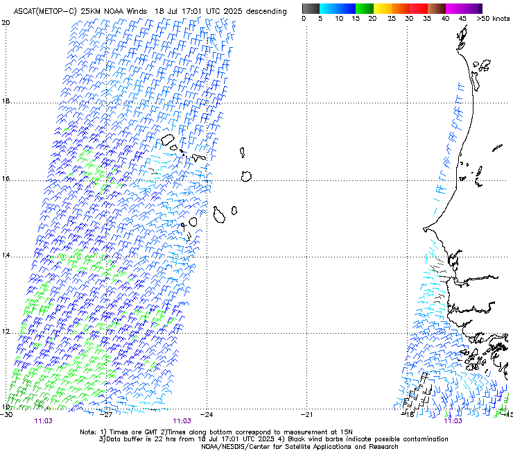
wxman57 wrote:ASCAT-C descending pass from 11Z did not indicate an LLC or 35kt winds. This may still be an open wave. It's fighting another round of SAL coming in from the east now. May not really get going until it passes north of the eastern Caribbean on Saturday. 12Z EC shifted about 60 miles east, passing closer to Bermuda next Monday evening.
wxman57 wrote:ASCAT-C descending pass from 11Z did not indicate an LLC or 35kt winds. This may still be an open wave. It's fighting another round of SAL coming in from the east now. May not really get going until it passes north of the eastern Caribbean on Saturday. 12Z EC shifted about 60 miles east, passing closer to Bermuda next Monday evening.
JetFuel_SE wrote:wxman57 wrote:ASCAT-C descending pass from 11Z did not indicate an LLC or 35kt winds. This may still be an open wave. It's fighting another round of SAL coming in from the east now. May not really get going until it passes north of the eastern Caribbean on Saturday. 12Z EC shifted about 60 miles east, passing closer to Bermuda next Monday evening.
would you be kind enough to show said ASCAT pass?
There are some
indications there might some northwesterly shear impinging on the
cyclone in 96-120 h, so I elected to stay under these aids for this
cycle.


Cachondo23 wrote:Hurricane2022 wrote:Unfortunately, Cape Verde has reported damages and 5 deaths from the newly-upgraded Tropical Storm ERIN.
https://x.com/dtudo1poucocv/status/1954862958984540427
Who knows if PTC advisories could have avoided this situation. At least have them prepared that squally weather was in their geographical area.


cycloneye wrote:Dont know if my eyes are tricking me, but it looks like a little bend WSW.
https://i.imgur.com/iG2QJxe.gif
cycloneye wrote:Dont know if my eyes are tricking me, but it looks like a little bend WSW.
https://i.imgur.com/iG2QJxe.gif


cycloneye wrote:Dont know if my eyes are tricking me, but it looks like a little bend WSW.
https://i.imgur.com/iG2QJxe.gif
Users browsing this forum: No registered users and 12 guests