InfernoFlameCat wrote:When is the next plane?
4 AM NOAA.
Moderators: hurricanetrack, S2k Moderators


InfernoFlameCat wrote:When is the next plane?

InfernoFlameCat wrote:When is the next plane?
cycloneye wrote:InfernoFlameCat wrote:When is the next plane?
4 AM NOAA.


cycloneye wrote:The pressure did not work so wait for the dropsonde.

cycloneye wrote:InfernoFlameCat wrote:When is the next plane?
4 AM NOAA.


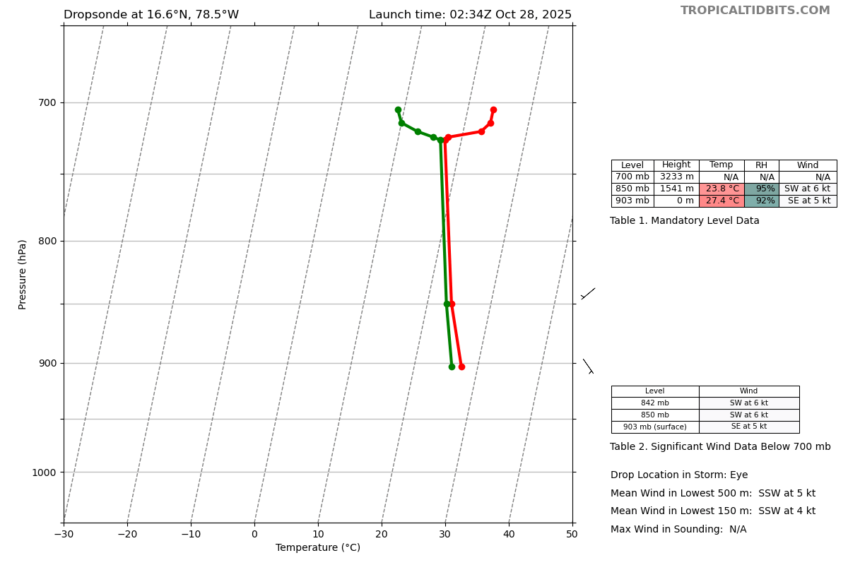
zzzh wrote:972
UZNT13 KNHC 280247
XXAA 78038 99166 70785 04468 99903 27415 14505 00/// ///// /////
92/// ///// ///// 85541 23808 22006 70233 ///// 88999 77999
31313 09608 80234
61616 AF301 2213A MELISSA OB 22
62626 CENTER MBL WND 20505 AEV 40002 DLM WND 21005 903842 WL150 2
0504 080 REL 1660N07854W 023616 SPG 1660N07854W 023706 =
XXBB 78038 99166 70785 04468 00903 27415 11850 23808 22726 17407
33724 17823 44720 22860 55714 24064 66705 24065
21212 00903 14505 11850 22006 22842 23006
31313 09608 80234
61616 AF301 2213A MELISSA OB 22
62626 CENTER MBL WND 20505 AEV 40002 DLM WND 21005 903842 WL150 2
0504 080 REL 1660N07854W 023616 SPG 1660N07854W 023706 =
;
dropsonde 903mb

Teban54 wrote:Travorum wrote:Teban54 wrote:Keep in mind that this AF plane's extrap pressure on the last pass was too low: it was extrapolating 903 mb, when two dropsonades from different aircraft confirmed 907 mb.
So hold your breath once you see the pressure, until the dropsonade confirms it.
Or the AF plane could just not broadcast extrap pressure and we can wait for the dropsonde apparently.

Anyway, NE quad has 162 kt FL, similar to SW. Some other recent passes also had surprisingly high FL winds in the SW quad as well.
Teban54 wrote:cycloneye wrote:InfernoFlameCat wrote:When is the next plane?
4 AM NOAA.
The current AF plane has an exit time of 0530z (1:30 am EDT) for a 6-hour-long mission, so it should do a few more passes (if I understood it correctly).

Fancy1002 wrote:
It seems like it broke and didn’t reach the surface.
Return to “Active Storms/Invests - Atlantic/EastPAC/CentralPAC/MED”
Users browsing this forum: No registered users and 118 guests