NATL: KAREN - Post-Tropical - Discussion
Moderators: hurricanetrack, S2k Moderators

The posts in this forum are NOT official forecasts and should not be used as such. They are just the opinion of the poster and may or may not be backed by sound meteorological data. They are NOT endorsed by any professional institution or STORM2K. For official information, please refer to products from the National Hurricane Center and National Weather Service.


Re: NATL: INVEST 96L - Discussion (40/40): Update - STWO issued at 635 PM
I hate myself for buying into to the idea of 96L being tagged as a TD or TS but........ if it is - IT IS. This this has the prerequisite features that would define a T.D. (or stronger). I don't know what the hell the SST's are up there, but i'm willing to give it it's due. If the T #'s are there - name it.
0 likes
Andy D
(For official information, please refer to the NHC and NWS products.)
(For official information, please refer to the NHC and NWS products.)
-
tropicwatch

- Category 5

- Posts: 3419
- Age: 61
- Joined: Sat Jun 02, 2007 10:01 am
- Location: Panama City Florida
- Contact:
Re: NATL: INVEST 96L - Discussion (40/40): Update - STWO issued at 635 PM
chaser1 wrote:I hate myself for buying into to the idea of 96L being tagged as a TD or TS but........ if it is - IT IS. This this has the prerequisite features that would define a T.D. (or stronger). I don't know what the hell the SST's are up there, but i'm willing to give it it's due. If the T #'s are there - name it.
Not very warm i would guess.. Closest buoy about 800 miles to its northeast reporting 60 and about 1100 miles to its east 62.
0 likes
Tropicwatch
Agnes 72', Eloise 75, Elena 85', Kate 85', Charley 86', Florence 88', Beryl 94', Dean 95', Erin 95', Opal 95', Earl 98', Georges 98', Ivan 2004', Arlene 2005', Dennis 2005', Ida 2009' Debby 2012' Irma 2017' Michael 2018'
Agnes 72', Eloise 75, Elena 85', Kate 85', Charley 86', Florence 88', Beryl 94', Dean 95', Erin 95', Opal 95', Earl 98', Georges 98', Ivan 2004', Arlene 2005', Dennis 2005', Ida 2009' Debby 2012' Irma 2017' Michael 2018'
Re: NATL: INVEST 96L - Discussion (40/40): Update - STWO issued at 635 PM
Europa non è lontana wrote:TallyTracker wrote:I find it odd that the NHC would potentially initiate advisories on a system that is near 45N even if it has tropical characteristics. I would think being at least at in or near the subtropics would be part of the criteria.
To paraphrase Dr Knabb — if it looks like a subtropical storm, it probably is, despite its environment and unusual location. Anyway, the NHC's area of responsibility extends throughout the entire North Atlantic basin, as far as I'm aware.
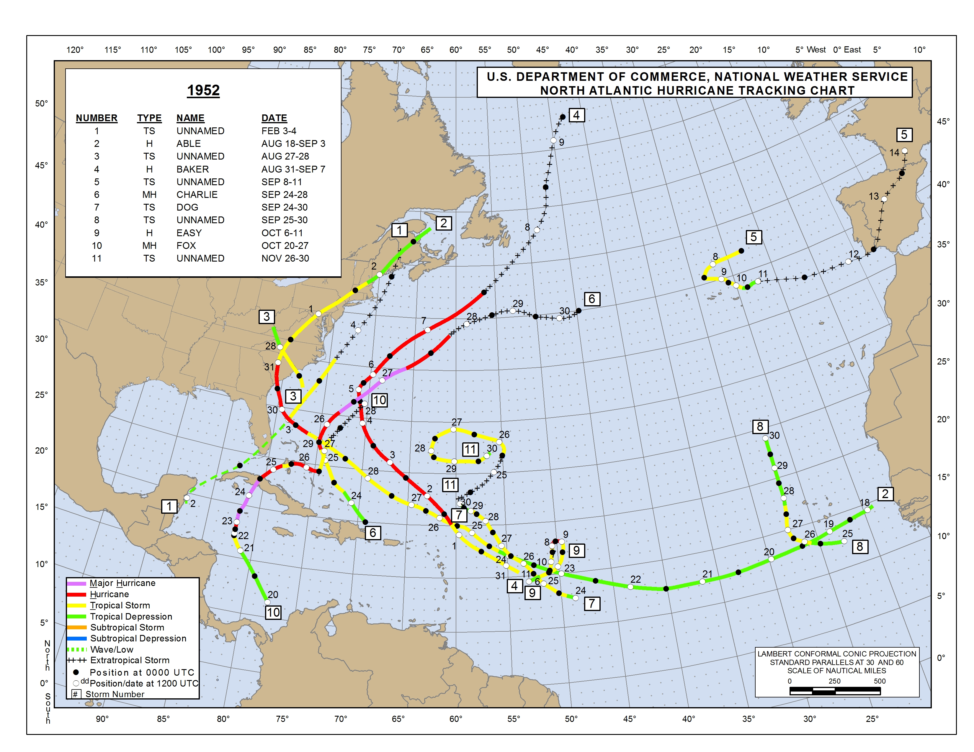
Folks, As weird as this season has been, it may get weirder!
A look just now at historical genesis locations on record tells me that 96L, already way up near 44.5N, would easily become the furthest N genesis for either a TC or STC as the furthest N on record is 42N (unnamed storm in 1952)!
https://en.wikipedia.org/wiki/1952_Atla ... Storm_Five
https://www.nhc.noaa.gov/data/tracks/tracks-at-1952.png
0 likes
Personal Forecast Disclaimer:
The posts in this forum are NOT official forecasts and should not be used as such. They are just the opinion of the poster and may or may not be backed by sound meteorological data. They are NOT endorsed by any professional institution or storm2k.org. For official information, please refer to the NHC and NWS products.
The posts in this forum are NOT official forecasts and should not be used as such. They are just the opinion of the poster and may or may not be backed by sound meteorological data. They are NOT endorsed by any professional institution or storm2k.org. For official information, please refer to the NHC and NWS products.
-
Europa non è lontana

- Tropical Storm

- Posts: 113
- Joined: Wed Nov 11, 2020 10:01 pm
Re: NATL: INVEST 96L - Discussion (40/40): Update - STWO issued at 635 PM
chaser1 wrote:I don't know what the hell the SST's are up there, but i'm willing to give it it's due. If the T #'s are there - name it.
20°C at the moment, which is very marginal, but Pablo in 2019 managed to become a hurricane with similar SSTs.
0 likes
-
JetFuel_SE

- Category 1

- Posts: 286
- Age: 26
- Joined: Thu Apr 30, 2020 3:57 pm
Re: NATL: INVEST 96L - Discussion (40/40): Update - STWO issued at 635 PM
Europa non è lontana wrote:chaser1 wrote:I don't know what the hell the SST's are up there, but i'm willing to give it it's due. If the T #'s are there - name it.
20°C at the moment, which is very marginal, but Pablo in 2019 managed to become a hurricane with similar SSTs.
I believe Arlene 2017 formed over even colder SSTs.
0 likes
-
Sciencerocks
- Category 5
- Posts: 9781
- Age: 39
- Joined: Thu Jul 06, 2017 1:51 am
Re: NATL: INVEST 96L - Discussion (40/40): Update - STWO issued at 635 PM

I'd estimate 55 knts and certainly the better looking of the Atlantic systems!
4 likes
-
Europa non è lontana
- Tropical Storm
- Posts: 113
- Joined: Wed Nov 11, 2020 10:01 pm
Re: NATL: INVEST 96L - Discussion (60/60)
60/60
North Atlantic (AL96):
Showers and thunderstorms continue to show signs of organization
with a small gale-force area of low pressure located several hundred
miles to the northwest of the Azores. Only a small increase in
organization could result in the formation of a subtropical
or tropical storm as soon as tonight, as the system moves slowly
northwestward. Over the weekend, the system is expected to move
over cooler waters, ending its chances of further development. For
more information on this system, including gale warnings, see High
Seas Forecasts issued by the National Weather Service and Meteo
France.
* Formation chance through 48 hours...medium...60 percent.
* Formation chance through 7 days...medium...60 percent.
0 likes
Re: NATL: INVEST 96L - Discussion (60/60)
Instead of complaining to the manager, Karen complained to forecaster Papin because she insisted on this storm being named for her so she can be almost guaranteed a return in 2031 to bother us yet again. 
6 likes
Personal Forecast Disclaimer:
The posts in this forum are NOT official forecasts and should not be used as such. They are just the opinion of the poster and may or may not be backed by sound meteorological data. They are NOT endorsed by any professional institution or storm2k.org. For official information, please refer to the NHC and NWS products.
The posts in this forum are NOT official forecasts and should not be used as such. They are just the opinion of the poster and may or may not be backed by sound meteorological data. They are NOT endorsed by any professional institution or storm2k.org. For official information, please refer to the NHC and NWS products.
-
Sciencerocks
- Category 5
- Posts: 9781
- Age: 39
- Joined: Thu Jul 06, 2017 1:51 am
Re: NATL: INVEST 96L - Discussion (60/60)
Should have gone 100% for that one.  It is a certainty. This thing would have to be decoupled in the next 2.5 hours to not be deserving.
7 likes
-
cycloneye

- Admin

- Posts: 147739
- Age: 69
- Joined: Thu Oct 10, 2002 10:54 am
- Location: San Juan, Puerto Rico
Re: NATL: INVEST 96L - Discussion (60/60)
Dvorak at 3.0. 
A. TROPICAL DISTURBANCE (96L)
B. 10/0000Z
C. 44.4N
D. 33.3W
E. THREE/GOES-E
F. T3.0/3.0
G. IR/EIR/PRXY
H. REMARKS...6.5/10 BANDING RESULTS IN A DT OF 3.0. SYSTEM HAS
TRANSITIONED TO MORE TROPICAL STATUS. MDTLY COLD CONVECTIVE TOPS TO -52
C. MET AND PT N/A. FT BASED ON DT.
I. ADDL POSITIONS
NIL
...KONON
B. 10/0000Z
C. 44.4N
D. 33.3W
E. THREE/GOES-E
F. T3.0/3.0
G. IR/EIR/PRXY
H. REMARKS...6.5/10 BANDING RESULTS IN A DT OF 3.0. SYSTEM HAS
TRANSITIONED TO MORE TROPICAL STATUS. MDTLY COLD CONVECTIVE TOPS TO -52
C. MET AND PT N/A. FT BASED ON DT.
I. ADDL POSITIONS
NIL
...KONON
1 likes
Visit the Caribbean-Central America Weather Thread where you can find at first post web cams,radars
and observations from Caribbean basin members Click Here
and observations from Caribbean basin members Click Here
-
StormWeather

- Category 1
- Posts: 442
- Joined: Wed Jun 05, 2024 2:34 pm
Re: NATL: INVEST 96L - Discussion (60/60)
cycloneye wrote:Dvorak at 3.0.A. TROPICAL DISTURBANCE (96L)
B. 10/0000Z
C. 44.4N
D. 33.3W
E. THREE/GOES-E
F. T3.0/3.0
G. IR/EIR/PRXY
H. REMARKS...6.5/10 BANDING RESULTS IN A DT OF 3.0. SYSTEM HAS
TRANSITIONED TO MORE TROPICAL STATUS. MDTLY COLD CONVECTIVE TOPS TO -52
C. MET AND PT N/A. FT BASED ON DT.
I. ADDL POSITIONS
NIL
...KONON
Is this thing gunning to become an unexpected hurricane as well?!
2 likes
Just an average cyclone tracker
The posts in this forum are NOT official forecasts and should not be used as such. They are just the opinion of the poster and may or may not be backed by sound meteorological data. They are NOT endorsed by any professional institution or storm2k.org. For official information, please refer to the NHC and NWS products
The posts in this forum are NOT official forecasts and should not be used as such. They are just the opinion of the poster and may or may not be backed by sound meteorological data. They are NOT endorsed by any professional institution or storm2k.org. For official information, please refer to the NHC and NWS products

Re: NATL: KAREN - Subtropical Storm - Discussion
AL, 11, 2025101000, , BEST, 0, 444N, 334W, 40, 998, SS, 34, NEQ, 20, 50, 50, 30, 1012, 190, 20, 55, 0, L, 0, , 0, 0, KAREN, S, 0, , 0, 0, 0, 0, genesis-num, 033, TRANSITIONED, alB62025 to al112025,
7 likes
-
CrazyC83
- Professional-Met

- Posts: 34127
- Joined: Tue Mar 07, 2006 11:57 pm
- Location: Deep South, for the first time!
Re: NATL: Karen - Subtropical Storm - Discussion
Even though, most likely in the ultimate track, genesis will be moved upwards (maybe to this morning), genesis would still be north of 40°N. But operationally this is so far north...about the same latitude as Burlington, VT or Halifax, NS.
I would also take the sub off of it - I would give it a full tropical classification. It doesn't look to be embedded in any upper level system and it has a small RMW.
I would also take the sub off of it - I would give it a full tropical classification. It doesn't look to be embedded in any upper level system and it has a small RMW.
3 likes
-
AJC3

- Admin
- Posts: 4105
- Age: 61
- Joined: Tue Aug 31, 2004 7:04 pm
- Location: Ballston Spa, New York
- Contact:
Re: NATL: Karen - Subtropical Storm - Discussion
CrazyC83 wrote:Even though, most likely in the ultimate track, genesis will be moved upwards (maybe to this morning), genesis would still be north of 40°N. But operationally this is so far north...about the same latitude as Burlington, VT or Halifax, NS.
I would also take the sub off of it - I would give it a full tropical classification. It doesn't look to be embedded in any upper level system and it has a small RMW.
Phil did a great job explaining his rationale for the STS designation, which I totally agree with. It's hard to justify this being "fully tropical" given the low was baroclinically initiated beneath a mid to upper level low which is still located over the top of it. While the RMW did shrink as you mentioned, the convective top temperatures, supported by that cold core low (and needed given the low SSTs), aren't all that cold, as Phil mentioned. That's not surprising for a system this far north. More often than not, these high-latitude ST systems wind up decaying by their own hand - the latent heat release from the convection being generated warms the air aloft, in turn weakening the cold low aloft and the associated temperature lapse rates needed to maintain the convection. SSTs would need to warm along its path to compensate for this, which isn't usually the case (and not here either).
In any event, as you well know, cyclone structure/phase lies along a spectrum. Categorization is sometimes difficult, to a large degree subjective, and usually generates a lot of dicussion. It's no different with Karen, on S2K and elsewhere.
3 likes
-
Vince_and_Grace_fan

- Category 1
- Posts: 320
- Joined: Thu Nov 03, 2016 9:25 am
- Location: Szombathely (Hungary)
Re: NATL: KAREN - Subtropical Storm - Discussion
Here is a satellite animation from yesterday afternoon/evening (from my new X site).
https://x.com/Zivipotty/status/1976550495549591654
https://x.com/Zivipotty/status/1976550495549591654
2 likes
-
Europa non è lontana
- Tropical Storm
- Posts: 113
- Joined: Wed Nov 11, 2020 10:01 pm

-
Sciencerocks
- Category 5
- Posts: 9781
- Age: 39
- Joined: Thu Jul 06, 2017 1:51 am

-
MarioProtVI
- Category 5
- Posts: 1001
- Age: 24
- Joined: Sun Sep 29, 2019 7:33 pm
- Location: New Jersey
Re: NATL: KAREN - Post-Tropical - Discussion
Karen found the manager.
Post-Tropical Cyclone Karen RSS Feed icon Satellite | Buoys | Grids | Storm Archive
...KAREN LOSES SUBTROPICAL CHARACTERISTICS OVER THE NORTH ATLANTIC...
9:00 PM GMT Fri Oct 10
Location: 47.5°N 30.2°W
Moving: NNE at 16 mph
Min pressure: 1000 mb
Max sustained: 45 mph
...KAREN LOSES SUBTROPICAL CHARACTERISTICS OVER THE NORTH ATLANTIC...
9:00 PM GMT Fri Oct 10
Location: 47.5°N 30.2°W
Moving: NNE at 16 mph
Min pressure: 1000 mb
Max sustained: 45 mph
3 likes
-
Europa non è lontana
- Tropical Storm
- Posts: 113
- Joined: Wed Nov 11, 2020 10:01 pm
Re: NATL: KAREN - Post-Tropical - Discussion
I'd hazard a guess that formation time will be pushed back around 6-12 hours, but a recordbreaker either way.
0 likes
-
Sciencerocks
- Category 5
- Posts: 9781
- Age: 39
- Joined: Thu Jul 06, 2017 1:51 am
Re: NATL: KAREN - Post-Tropical - Discussion
Probably closer to 18 hours. This thing looked good the next before. I also think it peaked at 55 knts yesterday.
0 likes
Return to “Active Storms/Invests - Atlantic/EastPAC/CentralPAC/MED”
Who is online
Users browsing this forum: No registered users and 74 guests