NATL: MELISSA - Hurricane - Discussion
Moderators: hurricanetrack, S2k Moderators

The posts in this forum are NOT official forecasts and should not be used as such. They are just the opinion of the poster and may or may not be backed by sound meteorological data. They are NOT endorsed by any professional institution or STORM2K. For official information, please refer to products from the National Hurricane Center and National Weather Service.

Re: NATL: MELISSA - Hurricane - Discussion
Most major hurricanes approach Jamaica from the ESE. With the mountainous island oriented that same direction, hurricanes frequently duck in a game of chicken with the island and miss... Gilbert being a very noteworthy exception. Now we have a hurricane pointed perpendicular at the island....making escape impossible. This is a remarkable event...not just the storm intensity but the direction of attack. this one will stand out on historical maps
4 likes
-
Hurricane2022

- Category 5

- Posts: 1908
- Joined: Tue Aug 23, 2022 11:38 pm
- Location: Araçatuba, Brazil
Re: NATL: MELISSA - Hurricane - Discussion
COLD AS HELL 

4 likes
Sorry for the bad English sometimes...!
For reliable and detailed information for any meteorological phenomenon, please consult the National Hurricane Center, Joint Typhoon Warning Center , or your local Meteo Center.
--------
ECCE OMNIA NOVA FACIAM (Ap 21,5).
For reliable and detailed information for any meteorological phenomenon, please consult the National Hurricane Center, Joint Typhoon Warning Center , or your local Meteo Center.
--------
ECCE OMNIA NOVA FACIAM (Ap 21,5).
-
eastcoastFL

- Category 5
- Posts: 3993
- Age: 43
- Joined: Thu Apr 12, 2007 12:29 pm
- Location: Palm City, FL
Re: NATL: MELISSA - Hurricane - Discussion
Keldeo1997 wrote:https://media.discordapp.net/attachments/1157676956674949152/1432562041914130462/Screenshot_2025-10-27_214917.png?ex=690180de&is=69002f5e&hm=a05b8de0c86aa20a3a50242dde972b09ac76d622ec18abc2ba647d545752dc15&=&format=webp&quality=lossless
https://media.discordapp.net/attachments/1157676956674949152/1432562042484686918/image1.png?ex=690180de&is=69002f5e&hm=2af831500debd242480702edba4cd732588a502362ed794697603cfb5fd551fb&=&format=webp&quality=lossless&width=825&height=702
Hmm there is no Double wind max
Is Jamaica under all that rain?
0 likes
Personal Forecast Disclaimer:
The posts in this forum are NOT official forecast and should not be used as such. They are just the opinion of the poster and may or may not be backed by sound meteorological data. They are NOT endorsed by any professional institution or storm2k.org. For official information, please refer to the NHC and NWS products.
The posts in this forum are NOT official forecast and should not be used as such. They are just the opinion of the poster and may or may not be backed by sound meteorological data. They are NOT endorsed by any professional institution or storm2k.org. For official information, please refer to the NHC and NWS products.

Re: NATL: MELISSA - Hurricane - Discussion
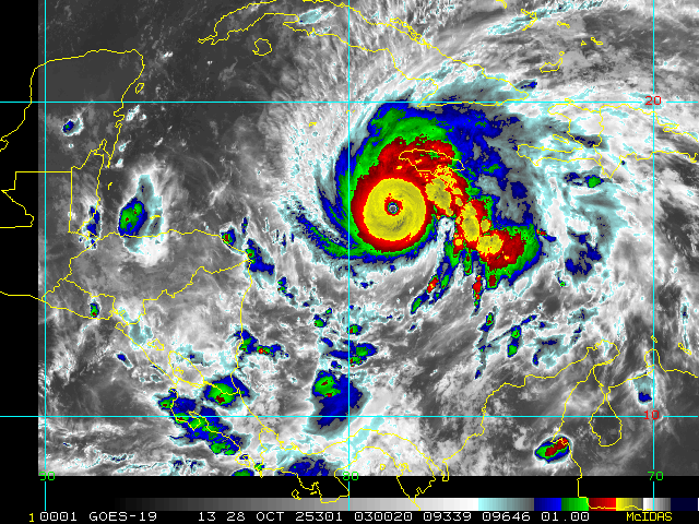
aspen wrote:As if Melissa couldn’t get any more ludicrous, the eye looks to be warming and the CDG is thickening on Dvorak imagery. I’ll be very surprised if next pass doesn’t yield 898-900mb, or lower.
I find CyclonicWx (by Alex Boreham, aka NotSparta on S2K) to be pretty good at viewing the -80~90 C range with greater detail. What it's showing right now is straight up ridiculous.

16 likes

Re: NATL: MELISSA - Hurricane - Discussion
Weird how each intense Hurricane is different, it hasn't had an EWRC at all since it became a MH while others barely last a few hours to start their EWRCs.
2 likes
Re: NATL: MELISSA - Hurricane - Discussion
CrazyC83 wrote:wx98 wrote:xtyphooncyclonex wrote:
Crazy how we have two "M" storms from two years in a row making the list. Guess the M curse is a thing
Weird that despite the “I” curse, there’s no I storms here and 3 M storms.
Strongest of the "I" storms was Ivan at 910 mb, followed by Irma at 914 mb.
Crazy that Irma wasn't lower in her lifespan. Was she just too large?
2 likes
Andrew (1992), Irene (1999), Frances (2004), Katrina (2005), Wilma (2005), Fay (2008), Irma (2017), Eta (2020), Ian (2022)
-
HurricaneRyan
- Category 3

- Posts: 839
- Age: 31
- Joined: Sun Dec 05, 2010 3:05 pm
Re: NATL: MELISSA - Hurricane - Discussion
When you realize that this will probably be landfalling tomorrow morning California time. 
0 likes
Kay '22 Hilary '23
-
CrazyC83
- Professional-Met

- Posts: 34286
- Joined: Tue Mar 07, 2006 11:57 pm
- Location: Deep South, for the first time!
Re: NATL: MELISSA - Hurricane - Discussion
One thing that is scary: these -90C cloud top outer bands are hitting Jamaica and likely producing massive flooding and mudslides in the mountains...and will continue to do so...
5 likes
Re: NATL: MELISSA - Hurricane - Discussion
Nuno wrote:CrazyC83 wrote:wx98 wrote:
Weird that despite the “I” curse, there’s no I storms here and 3 M storms.
Strongest of the "I" storms was Ivan at 910 mb, followed by Irma at 914 mb.
Crazy that Irma wasn't lower in her lifespan. Was she just too large?
Higher background pressure in the open Atlantic, especially at an earlier time of the year, would be my guess.
4 likes
Re: NATL: MELISSA - Hurricane - Discussion
CrazyC83 wrote:One thing that is scary: these -90C cloud top outer bands are hitting Jamaica and likely producing massive flooding and mudslides in the mountains...and will continue to do so...
And when they stop doing so, it wouldn't be long before they're replaced with -90C CDO instead, or if you're lucky, a 150 kt eye.
2 likes
-
Hurricane2022
- Category 5
- Posts: 1908
- Joined: Tue Aug 23, 2022 11:38 pm
- Location: Araçatuba, Brazil
Re: NATL: MELISSA - Hurricane - Discussion
Did I hear someone saying "next pass"?? 

1 likes
Sorry for the bad English sometimes...!
For reliable and detailed information for any meteorological phenomenon, please consult the National Hurricane Center, Joint Typhoon Warning Center , or your local Meteo Center.
--------
ECCE OMNIA NOVA FACIAM (Ap 21,5).
For reliable and detailed information for any meteorological phenomenon, please consult the National Hurricane Center, Joint Typhoon Warning Center , or your local Meteo Center.
--------
ECCE OMNIA NOVA FACIAM (Ap 21,5).
-
USTropics
- Professional-Met
- Posts: 2727
- Joined: Sun Aug 12, 2007 3:45 am
- Location: Florida State University
Re: NATL: MELISSA - Hurricane - Discussion
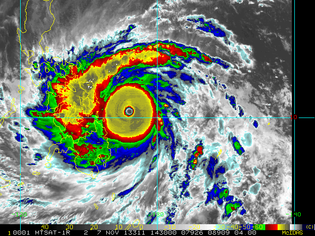
REDHurricane wrote:Hurricane models have Melissa strengthening up until landfall -- if that holds true we maaaaaybe could get in the ballpark of Wilma. Maybe.
That's truly the scary part, the satellite presentation and environment are quite literally pristine. The only thing holding Melissa back from reaching MPI is herself basically (e.g., inner core changes, like EWRC). Theoretically, Melissa could push ~875mb if the stars aligned:

8 likes
-
cheezyWXguy

- Category 5
- Posts: 6227
- Joined: Mon Feb 13, 2006 12:29 am
- Location: Dallas, TX
Re: NATL: MELISSA - Hurricane - Discussion
REDHurricane wrote:Hurricane models have Melissa strengthening up until landfall -- if that holds true we maaaaaybe could get in the ballpark of Wilma. Maybe.
Shaving off another 20mb could be a stretch, though I suppose it’s not impossible. Rivaling Allen’s wind speed record is also a tall order but seems more achievable to me if it can mix those winds aloft down a bit more efficiently.
0 likes
-
CrazyC83
- Professional-Met
- Posts: 34286
- Joined: Tue Mar 07, 2006 11:57 pm
- Location: Deep South, for the first time!
Re: NATL: MELISSA - Hurricane - Discussion
It has to move around Jamaica. It won't fly over it due to the mountains unless at cruising altitude.
1 likes
Re: NATL: MELISSA - Hurricane - Discussion
Nuno wrote:CrazyC83 wrote:wx98 wrote:
Weird that despite the “I” curse, there’s no I storms here and 3 M storms.
Strongest of the "I" storms was Ivan at 910 mb, followed by Irma at 914 mb.
Crazy that Irma wasn't lower in her lifespan. Was she just too large?
Probably higher background pressure in the Atlantic making it harder to get lower (but low relative to the surrounding environment).
1 likes
-
mrbagyo

- Category 5
- Posts: 3875
- Age: 33
- Joined: Thu Apr 12, 2012 9:18 am
- Location: 14.13N 120.98E
- Contact:
Re: NATL: MELISSA - Hurricane - Discussion
As good as it gets but ill still give the crown to Haiyan in terms of savage appearance (its pretty close)
11 likes
The posts in this forum are NOT official forecast and should not be used as such. They are just the opinion of the poster and may or may not be backed by sound meteorological data. They are NOT endorsed by any professional institution or storm2k.org. For official information, please refer to RSMC, NHC and NWS products.
-
dukeblue219
- S2K Supporter

- Posts: 556
- Joined: Fri Sep 30, 2016 3:52 pm
Re: NATL: MELISSA - Hurricane - Discussion
The plane didn't turn around, if that's what you're suggesting. There's something weird in the very last data point so the plane looked stationary to the plotting app, which must have defaulted to pointing Eastward.
3 likes
-
drewschmaltz
- S2K Supporter
- Posts: 351
- Joined: Thu Aug 27, 2015 8:19 pm
Re: NATL: MELISSA - Hurricane - Discussion
I just learned a bit about mountain "prominence" while hiking mt rainer. Though it's not the tallest in the lower 48, it has by far the most prominence. Is such a record kept for hurricanes? Their mb differential?
1 likes
I HAVE ABSOLUTELY NO IDEA WHAT I'M TALKING ABOUT. PLEASE CONSULT SOMEONE WHO DOES. START WITH THE NHC. ALL POSTS ARE FOR ENTERTAINMENT PURPOSES ONLY.
-
ElectricStorm

- Category 5
- Posts: 5121
- Age: 24
- Joined: Tue Aug 13, 2019 11:23 pm
- Location: Skiatook, OK / Norman, OK
Re: NATL: MELISSA - Hurricane - Discussion
I think that's just a TT error, it says bearing 90 degrees at 0kts. This happened with last night's mission a couple times as well.
3 likes
B.S Meteorology, University of Oklahoma '25
Please refer to the NHC, NWS, or SPC for official information.
Please refer to the NHC, NWS, or SPC for official information.
-
Hurrilurker

- Category 2

- Posts: 738
- Joined: Mon Jun 09, 2003 3:32 pm
- Location: San Francisco, CA
Re: NATL: MELISSA - Hurricane - Discussion
aspen wrote:The CDO is getting even smoother on recent meso floater frames. This is really pushing what is physically possible for an Atlantic storm.
I’m praying enough people in Jamaica have realized how bad this is and have taken all the necessary precautions, because I don’t like how public officials were downplaying Melissa’s threats a few days ago. Bad communication in a situation like this could lead to a devastating loss of life.
Even if they pack the shelters with tons of people, I'm starting to worry that structurally they may not be up to the task of this kind of storm intensity, like we're almost in 5+ territory. I guess the good news is it looks like Kingston will be spared a direct hit from the worst of the storm, if I were on the island I would head as far east as possible (though not on the coast).
2 likes
Return to “Active Storms/Invests - Atlantic/EastPAC/CentralPAC/MED”
Who is online
Users browsing this forum: No registered users and 114 guests