
https://x.com/JamaicaObserver/status/1982109709982150875
NATL: MELISSA - Hurricane - Discussion
Moderators: hurricanetrack, S2k Moderators

The posts in this forum are NOT official forecasts and should not be used as such. They are just the opinion of the poster and may or may not be backed by sound meteorological data. They are NOT endorsed by any professional institution or STORM2K. For official information, please refer to products from the National Hurricane Center and National Weather Service.

-
cheezyWXguy

- Category 5

- Posts: 6195
- Joined: Mon Feb 13, 2006 12:29 am
- Location: Dallas, TX
Re: NATL: MELISSA - Tropical Storm - Discussion
I’m not sold on the contraction to pinhole eye though, that eye looks about average sized. Good news is that probably means a Milton or Wilma-level explosion isn’t as likely, but bad news is a larger core won’t collapse as quickly into an ewrc upon reaching peak. Could still undergo one, but would probably stabilize for a while first. Won’t matter much either way though, it’s hard to bet against a cat5 peak at this point so Jamaica better be taking this seriously
3 likes
Re: NATL: MELISSA - Tropical Storm - Discussion
Not going to see an eye for a while.
Cirrus spewing from the hot towers will obscure it.
Probably a high-end Cat 1 within the hour.
Cirrus spewing from the hot towers will obscure it.
Probably a high-end Cat 1 within the hour.
0 likes
-
cycloneye

- Admin

- Posts: 148049
- Age: 69
- Joined: Thu Oct 10, 2002 10:54 am
- Location: San Juan, Puerto Rico
Re: NATL: MELISSA - Tropical Storm - Discussion
cheezyWXguy wrote:I’m not sold on the contraction to pinhole eye though, that eye looks about average sized. Good news is that probably means a Milton or Wilma-level explosion isn’t as likely, but bad news is a larger core won’t collapse as quickly into an ewrc upon reaching peak. Could still undergo one, but would probably stabilize for a while first. Won’t matter much either way though, it’s hard to bet against a cat5 peak at this point so Jamaica better be taking this seriously
The worse part is that it will move very slow to prolong the effects for 48 hours or more on the island.
3 likes
Visit the Caribbean-Central America Weather Thread where you can find at first post web cams,radars
and observations from Caribbean basin members Click Here
and observations from Caribbean basin members Click Here
-
ScottNAtlanta

- Category 5
- Posts: 2487
- Joined: Sat May 25, 2013 3:11 pm
- Location: Atlanta, GA
Re: NATL: MELISSA - Tropical Storm - Discussion
Radar is showing a west movement
https://zoom.earth/places/jamaica/#map=radar
https://zoom.earth/places/jamaica/#map=radar
1 likes
The posts in this forum are NOT official forecast and should not be used as such. They are just the opinion of the poster and may or may not be backed by sound meteorological data. They are NOT endorsed by any professional institution or storm2k.org. For official information, please refer to the NHC and NWS products.
-
MHC Tracking
- Tropical Storm

- Posts: 203
- Joined: Mon Mar 15, 2021 10:05 am
Re: NATL: MELISSA - Tropical Storm - Discussion
GCANE wrote:Usually when a strong RI occurs a EWRC quickly ensues right after.
Wonder if one will be underway before Jamaica.
Praying that it does.
An EWRC would likely exacerbate the situation by broadening the radius of hurricane-force winds and in turn increasing surge
1 likes
-
MHC Tracking
- Tropical Storm
- Posts: 203
- Joined: Mon Mar 15, 2021 10:05 am
Re: NATL: MELISSA - Tropical Storm - Discussion
cheezyWXguy wrote:I’m not sold on the contraction to pinhole eye though, that eye looks about average sized. Good news is that probably means a Milton or Wilma-level explosion isn’t as likely, but bad news is a larger core won’t collapse as quickly into an ewrc upon reaching peak. Could still undergo one, but would probably stabilize for a while first. Won’t matter much either way though, it’s hard to bet against a cat5 peak at this point so Jamaica better be taking this seriously
I'm not "downcasting" but I remain a bit doubtful of a Cat 5 peak. Downsloping from Jamaica has interfered with the development of hurricanes in the past (see: Grace 2021), it feels possible that it does so here as well.
0 likes
-
Iceresistance

- Category 5
- Posts: 9333
- Age: 22
- Joined: Sat Oct 10, 2020 9:45 am
- Location: Tecumseh, OK/Norman, OK
Re: NATL: MELISSA - Tropical Storm - Discussion
GCANE wrote:Tower is tightening up the eyewall
Likely a pinhole in 24 hrs.
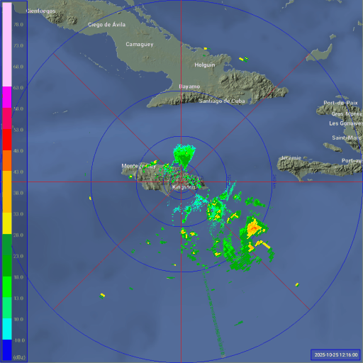
https://metservice.gov.jm/daily-forecast/radar/
Can you post the radar image for me? I can't see it for some reason
2 likes
Bill 2015 & Beta 2020
Winter 2020-2021
All observations are in Tecumseh, OK unless otherwise noted.
Winter posts are focused mainly for Oklahoma & Texas.
Take any of my forecasts with a grain of salt, refer to the NWS, SPC, and NHC for official information
Never say Never with weather! Because ANYTHING is possible!
Winter 2020-2021
All observations are in Tecumseh, OK unless otherwise noted.
Winter posts are focused mainly for Oklahoma & Texas.
Take any of my forecasts with a grain of salt, refer to the NWS, SPC, and NHC for official information
Never say Never with weather! Because ANYTHING is possible!


Re: NATL: MELISSA - Hurricane - Discussion
There it is. We officially have Hurricane Melissa.
3 likes
-
HurricaneRyan
- Category 3

- Posts: 832
- Age: 31
- Joined: Sun Dec 05, 2010 3:05 pm

Re: NATL: MELISSA - Tropical Storm - Discussion
ScottNAtlanta wrote:Radar is showing a west movement
https://zoom.earth/places/jamaica/#map=radar
NHC is blending the ECM track a little, the 2 PM NHC update still reporting a WNW motion.
Could be a wobble or start of a new 6 hour motion, the sooner the west turn comes the better for Kingston.
Current forecast would put Kingston in the core winds for about 24 hours starting around Monday noon.
Mostly focusing on the flooding potential which is a much larger area.
0 likes
-
USTropics
- Professional-Met

- Posts: 2692
- Joined: Sun Aug 12, 2007 3:45 am
- Location: Florida State University
Re: NATL: MELISSA - Tropical Storm - Discussion
MHC Tracking wrote:cheezyWXguy wrote:I’m not sold on the contraction to pinhole eye though, that eye looks about average sized. Good news is that probably means a Milton or Wilma-level explosion isn’t as likely, but bad news is a larger core won’t collapse as quickly into an ewrc upon reaching peak. Could still undergo one, but would probably stabilize for a while first. Won’t matter much either way though, it’s hard to bet against a cat5 peak at this point so Jamaica better be taking this seriously
I'm not "downcasting" but I remain a bit doubtful of a Cat 5 peak. Downsloping from Jamaica has interfered with the development of hurricanes in the past (see: Grace 2021), it feels possible that it does so here as well.
We we will need six things to achieve maximum potential intensity (MPI) here (a real possibility), I'll list it from very likely -> unknown:
1) High OHC (obvious we have this)
2) Wind shear to decrease to > 10kt (very likely)
3) Subsidence/dry air entrainment to be minimal (very likely)
4) Efficient outflow to rapidly advect updrafted air away (likely)
5) A pinhole eye to sustain RI to cat 5 (unknown, only mesoscale models can parameterize this)
6) Like you stated, it needs to stay far enough south of Jamaica to not have inflow disrupted (uncertain)
The NHC is following the consensus models (particularly HCCA) and hedging towards the Google DeepMind/EAIFS ensemble tracks currently (they've done shockingly well this year). Looking at mesoscale models that are following this track currently, HAFS-A again has the most accurate run at 12z:

HAFS-B has its peak at the same time, but more to the north in location:

HMON is similar to HAFS-B

I'm not buying the HWRF, as it's track is far too quick (landfall already tomorrow evening in Jamaica):

Again, I think the HAFS-A has done really well with the structural changes and speed of Melissa, and is supported by the best performing consensus model and the AI ensemble suite. I think RI is almost certain imo and Cat 4/5 is a real possibility depending on that initial structure (i.e., no EWRC and ability for radial winds to refine a pinhole eye structure).

9 likes
-
Hurricane2022

- Category 5
- Posts: 1772
- Joined: Tue Aug 23, 2022 11:38 pm
- Location: Araçatuba, Brazil
Re: NATL: MELISSA - Hurricane - Discussion
1 likes
Sorry for the bad English sometimes...!
For reliable and detailed information for any meteorological phenomenon, please consult the National Hurricane Center, Joint Typhoon Warning Center , or your local Meteo Center.
--------
ECCE OMNIA NOVA FACIAM (Ap 21,5).
For reliable and detailed information for any meteorological phenomenon, please consult the National Hurricane Center, Joint Typhoon Warning Center , or your local Meteo Center.
--------
ECCE OMNIA NOVA FACIAM (Ap 21,5).

Re: NATL: MELISSA - Tropical Storm - Discussion
USTropics wrote:MHC Tracking wrote:cheezyWXguy wrote:I’m not sold on the contraction to pinhole eye though, that eye looks about average sized. Good news is that probably means a Milton or Wilma-level explosion isn’t as likely, but bad news is a larger core won’t collapse as quickly into an ewrc upon reaching peak. Could still undergo one, but would probably stabilize for a while first. Won’t matter much either way though, it’s hard to bet against a cat5 peak at this point so Jamaica better be taking this seriously
I'm not "downcasting" but I remain a bit doubtful of a Cat 5 peak. Downsloping from Jamaica has interfered with the development of hurricanes in the past (see: Grace 2021), it feels possible that it does so here as well.
We we will need six things to achieve maximum potential intensity (MPI) here (a real possibility), I'll list it from very likely -> unknown:
1) High OHC (obvious we have this)
2) Wind shear to decrease to > 10kt (very likely)
3) Subsidence/dry air entrainment to be minimal (very likely)
4) Efficient outflow to rapidly advect updrafted air away (likely)
5) A pinhole eye to sustain RI to cat 5 (unknown, only mesoscale models can parameterize this)
6) Like you stated, it needs to stay far enough south of Jamaica to not have inflow disrupted (uncertain)
The NHC is following the consensus models (particularly HCCA) and hedging towards the Google DeepMind/EAIFS ensemble tracks currently (they've done shockingly well this year). Looking at mesoscale models that are following this track currently, HAFS-A again has the most accurate run at 12z:
https://i.imgur.com/9dgtsNI.png
HAFS-B has its peak at the same time, but more to the north in location:
https://i.imgur.com/rVLVqBm.png
HMON is similar to HAFS-B
https://i.imgur.com/tdL3qjo.png
I'm not buying the HWRF, as it's track is far too quick (landfall already tomorrow evening in Jamaica):
https://i.imgur.com/RnFgpIR.png
Again, I think the HAFS-A has done really well with the structural changes and speed of Melissa, and is supported by the best performing consensus model and the AI ensemble suite. I think RI is almost certain imo and Cat 4/5 is a real possibility depending on that initial structure (i.e., no EWRC and ability for radial winds to refine a pinhole eye structure).
https://i.imgur.com/KhP5z5D.gif
Something interesting about both HAFS models is that for days they’ve shown Melissa being unable to fully clear out a nice eye, either pinhole or normal-sized. Could be due to structural factors or a tiny bit of shear left inhibiting effective clearing. It may also be an indication that we’ll see a high-end 4 peak, not a Cat 5. Although the difference in impacts between 150 and 160 mph is going to be pretty minimal — an absolute nightmare scenario regardless.
2 likes
Irene '11 Sandy '12 Hermine '16 5/15/2018 Derecho Fay '20 Isaias '20 Elsa '21 Henri '21 Ida '21
I am only a meteorology enthusiast who knows a decent amount about tropical cyclones. Look to the professional mets, the NHC, or your local weather office for the best information.
I am only a meteorology enthusiast who knows a decent amount about tropical cyclones. Look to the professional mets, the NHC, or your local weather office for the best information.
Re: NATL: MELISSA - Hurricane - Discussion
The 12z HAFS-B and A solution would be near-worst case scenarios for the Kingston area, with the core either just to the left or into the harbor.
Also, I did not know that Kingston's international airport is essentially in the middle of the harbor. Seems like a pretty bad place for an airport.


Also, I did not know that Kingston's international airport is essentially in the middle of the harbor. Seems like a pretty bad place for an airport.
3 likes

Re: NATL: MELISSA - Hurricane - Discussion
Pelicane wrote:
https://i.imgur.com/jUbxyTc.jpeg
Probably the worst place you could choose for a major airport in a hurricane-prone area.
2 likes
-
Blown Away

- S2K Supporter

- Posts: 10226
- Joined: Wed May 26, 2004 6:17 am
Re: NATL: MELISSA - Hurricane - Discussion
2:00 PM EDT Sat Oct 25
Location: 16.6°N 75.2°W
Moving: WNW at 1 mph
Min pressure: 980 mb
Max sustained: 75 mph
.1 degree N of 11am and was predicted to move .1 degrees S before W turn. May change angle towards Jamaica?
1 likes
Hurricane Eye Experience: David 79, Irene 99, Frances 04, Jeanne 04, Wilma 05… Hurricane Brush Experience: Andrew 92, Erin 95, Floyd 99, Matthew 16, Irma 17, Ian 22, Nicole 22…
-
cycloneye
- Admin
- Posts: 148049
- Age: 69
- Joined: Thu Oct 10, 2002 10:54 am
- Location: San Juan, Puerto Rico
Re: NATL: MELISSA - Hurricane - Discussion
Breaking News
Dvorak up to 5.0.
A. 13L (MELISSA)
B. 25/1800Z
C. 16.9N
D. 75.4W
E. THREE/GOES-E
F. T5.0/5.0
G. IR/EIR/VIS/GMI
H. REMARKS...LLCC EMBEDDED IN W RESULTS IN A DT OF 5.0. THE MET IS
4.5 BASED ON A RAPID DEVELOPMENT TREND OVER THE PAST 24 HOURS. THE PT
IS 5.0. THE FT IS BASED ON THE PT DUE TO THE UNCERTAINTY OF THE EXACT
CENTER POSITION.
B. 25/1800Z
C. 16.9N
D. 75.4W
E. THREE/GOES-E
F. T5.0/5.0
G. IR/EIR/VIS/GMI
H. REMARKS...LLCC EMBEDDED IN W RESULTS IN A DT OF 5.0. THE MET IS
4.5 BASED ON A RAPID DEVELOPMENT TREND OVER THE PAST 24 HOURS. THE PT
IS 5.0. THE FT IS BASED ON THE PT DUE TO THE UNCERTAINTY OF THE EXACT
CENTER POSITION.
3 likes
Visit the Caribbean-Central America Weather Thread where you can find at first post web cams,radars
and observations from Caribbean basin members Click Here
and observations from Caribbean basin members Click Here

Re: NATL: MELISSA - Hurricane - Discussion
H. REMARKS...LLCC EMBEDDED IN W RESULTS IN A DT OF 5.0. THE MET IS
4.5 BASED ON A RAPID DEVELOPMENT TREND OVER THE PAST 24 HOURS. THE PT
IS 5.0. THE FT IS BASED ON THE PT DUE TO THE UNCERTAINTY OF THE EXACT
CENTER POSITION.
4.5 BASED ON A RAPID DEVELOPMENT TREND OVER THE PAST 24 HOURS. THE PT
IS 5.0. THE FT IS BASED ON THE PT DUE TO THE UNCERTAINTY OF THE EXACT
CENTER POSITION.
We have a T5.0 fix on OSPO's 18z satellite bulletin.
1 likes
Return to “Active Storms/Invests - Atlantic/EastPAC/CentralPAC/MED”
Who is online
Users browsing this forum: Gladstone and 108 guests