NATL: MELISSA - Models
Moderators: hurricanetrack, S2k Moderators

The posts in this forum are NOT official forecasts and should not be used as such. They are just the opinion of the poster and may or may not be backed by sound meteorological data. They are NOT endorsed by any professional institution or STORM2K. For official information, please refer to products from the National Hurricane Center and National Weather Service.

-
IsabelaWeather
- Category 1

- Posts: 309
- Age: 36
- Joined: Tue Jul 07, 2020 7:29 am
- Location: Isabela, Puerto Rico
NATL: MELISSA - Models
Latest GFS run has it running into the DR and stalling, dropping feet of rain.
0 likes

Re: NATL: INVEST 98L - Models
IsabelaWeather wrote:Latest GFS run has it running into the DR and stalling, dropping feet of rain.
Then reforming as a gargantuan Sandy-style storm over the Bahamas.
0 likes
Igor 2010, Sandy 2012, Fay 2014, Gonzalo 2014, Joaquin 2015, Nicole 2016, Humberto 2019, Imelda 2025
I am only a tropical weather enthusiast. My predictions are not official and may or may not be backed by sound meteorological data. For official information, please refer to the NHC and NWS products.
I am only a tropical weather enthusiast. My predictions are not official and may or may not be backed by sound meteorological data. For official information, please refer to the NHC and NWS products.

Re: NATL: INVEST 98L - Models
Kazmit wrote:IsabelaWeather wrote:Latest GFS run has it running into the DR and stalling, dropping feet of rain.
Then reforming as a gargantuan Sandy-style storm over the Bahamas.
The last few runs of the deterministic GFS have been ticking west
1 likes
Re: NATL: INVEST 98L - Models
12z CMC ends in a precarious position for western Cuba and SFL with the trough approaching
https://www.tropicaltidbits.com/analysis/models/?model=gem®ion=atl&pkg=mslp_pcpn&runtime=2025101812&fh=6
https://www.tropicaltidbits.com/analysis/models/?model=gem®ion=atl&pkg=mslp_pcpn&runtime=2025101812&fh=6
0 likes
-
USTropics
- Professional-Met

- Posts: 2689
- Joined: Sun Aug 12, 2007 3:45 am
- Location: Florida State University
Re: NATL: INVEST 98L - Models
That's what we call Multiple Vorticity Disorder on the 12z GFS run:

That's quite the difference from the previous 06z run, where we had a dipole Central American Gyre (CAG) scenario centered over the central Caribbean:

Meanwhile, the 00z ECMWF keeps the CAG over...well..Central America

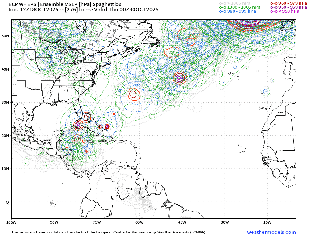
The 12z GFS ensembles are significantly spread as well:

Compared to 00z EMCWF ensembles:

It is CAG season, so definitely keeping tabs on how this unfolds. Typically the central point of the CAG does not lift as far north as the GFS is suggesting, and the ECMWF ensembles (+ the AI ensembles support) make me inclined to believe this could potentially be developing further south than the GFS is suggesting at 12z.
Something getting pulled north into Cuba, Jamaica, or Hispaniola is definitely a possibility if something is able to organize and deepen. Based on the synoptic agreement between the major ensemble models (GFS, ECMWF, and CMC) I don't see the potential for a system to make it as far west as the GOM (they're all showing a significant shortwave moving eastward during this timeframe):
GFS Ensembles

ECMWF Ensembles

CMC Ensembles

That's quite the difference from the previous 06z run, where we had a dipole Central American Gyre (CAG) scenario centered over the central Caribbean:
Meanwhile, the 00z ECMWF keeps the CAG over...well..Central America
The 12z GFS ensembles are significantly spread as well:
Compared to 00z EMCWF ensembles:
It is CAG season, so definitely keeping tabs on how this unfolds. Typically the central point of the CAG does not lift as far north as the GFS is suggesting, and the ECMWF ensembles (+ the AI ensembles support) make me inclined to believe this could potentially be developing further south than the GFS is suggesting at 12z.
Something getting pulled north into Cuba, Jamaica, or Hispaniola is definitely a possibility if something is able to organize and deepen. Based on the synoptic agreement between the major ensemble models (GFS, ECMWF, and CMC) I don't see the potential for a system to make it as far west as the GOM (they're all showing a significant shortwave moving eastward during this timeframe):
GFS Ensembles
ECMWF Ensembles
CMC Ensembles
6 likes
-
cycloneye

- Admin

- Posts: 147893
- Age: 69
- Joined: Thu Oct 10, 2002 10:54 am
- Location: San Juan, Puerto Rico
Re: NATL: INVEST 98L - Models
12z EURO develops after stalling near Nicaragua.

2 likes
Visit the Caribbean-Central America Weather Thread where you can find at first post web cams,radars
and observations from Caribbean basin members Click Here
and observations from Caribbean basin members Click Here

Re: NATL: INVEST 98L - Models
12Z UK: Nicaragua
0 likes
Personal Forecast Disclaimer:
The posts in this forum are NOT official forecasts and should not be used as such. They are just the opinion of the poster and may or may not be backed by sound meteorological data. They are NOT endorsed by any professional institution or storm2k.org. For official information, please refer to the NHC and NWS products.
The posts in this forum are NOT official forecasts and should not be used as such. They are just the opinion of the poster and may or may not be backed by sound meteorological data. They are NOT endorsed by any professional institution or storm2k.org. For official information, please refer to the NHC and NWS products.


-
cycloneye
- Admin
- Posts: 147893
- Age: 69
- Joined: Thu Oct 10, 2002 10:54 am
- Location: San Juan, Puerto Rico
Re: NATL: INVEST 98L - Models
18z GFS has huge gyre TC stalling over Hispaniola and if that occurs, it may be probably a top 5 humanitarian disaster. 

5 likes
Visit the Caribbean-Central America Weather Thread where you can find at first post web cams,radars
and observations from Caribbean basin members Click Here
and observations from Caribbean basin members Click Here
-
IsabelaWeather
- Category 1
- Posts: 309
- Age: 36
- Joined: Tue Jul 07, 2020 7:29 am
- Location: Isabela, Puerto Rico
Re: NATL: INVEST 98L - Models
cycloneye wrote:18z GFS has huge gyre TC stalling over Hispaniola and if that occurs, it may be probably a top 5 humanitarian disaster.
https://i.imgur.com/pY5POcs.gif
That would be insane, but I dont think thats really possible, is it? Seems too odd.
0 likes
-
cycloneye
- Admin
- Posts: 147893
- Age: 69
- Joined: Thu Oct 10, 2002 10:54 am
- Location: San Juan, Puerto Rico
Re: NATL: INVEST 98L - Models
Over 75 inches of rain for PR and DR.

3 likes
Visit the Caribbean-Central America Weather Thread where you can find at first post web cams,radars
and observations from Caribbean basin members Click Here
and observations from Caribbean basin members Click Here
-
Stormlover70
- Tropical Storm

- Posts: 193
- Age: 55
- Joined: Fri Jun 21, 2024 5:31 am
- Location: New port richey
-
DorkyMcDorkface

- Category 4

- Posts: 959
- Age: 27
- Joined: Mon Sep 30, 2019 1:32 pm
- Location: Mid-Atlantic
Re: NATL: INVEST 98L - Models
Euro might actually be correcting towards the GFS - it's showing a more consolidated system in the medium range and appears to be slowly ticking E from the SW part of the Caribbean to the Central Caribbean.

2 likes
Please note the thougths expressed by this account are solely those of the user and are from a hobbyist perspective. For more comprehensive analysis, consult an actual professional meteorologist or meteorology agency.
Floyd 1999 | Isabel 2003 | Hanna 2008 | Irene 2011 | Sandy 2012 | Isaias 2020
Re: NATL: INVEST 98L - Models
18Z ECAI also trended stronger in short term. The track is similar to GFS.
0 likes
Re: NATL: INVEST 98L - Models
It looks like the hurricane models aren’t going to be very helpful for the next couple days.
1 likes
-
ScottNAtlanta

- Category 5

- Posts: 2474
- Joined: Sat May 25, 2013 3:11 pm
- Location: Atlanta, GA
Re: NATL: INVEST 98L - Models
Thats 6 1/4 FEET of rain...wow
0 likes
The posts in this forum are NOT official forecast and should not be used as such. They are just the opinion of the poster and may or may not be backed by sound meteorological data. They are NOT endorsed by any professional institution or storm2k.org. For official information, please refer to the NHC and NWS products.
-
MEANINGLESS_NUMBERS
- Category 1
- Posts: 443
- Joined: Mon Nov 02, 2020 1:43 pm
Re: NATL: INVEST 98L - Models
Saw this. Unreal
0 likes
Emily '87, Felix '95, Gert '99, Fabian '03, Humberto '19, Paulette '20, Teddy '20, Fiona '22, Lee '23, Ernesto '24, Humberto/Imelda '25
Re: NATL: INVEST 98L - Models
At least that 75 inches isn’t over Haiti, I know it’s still bad, but the Dominican has better infrastructure.
0 likes
-
tropicwatch

- Category 5
- Posts: 3423
- Age: 61
- Joined: Sat Jun 02, 2007 10:01 am
- Location: Panama City Florida
- Contact:
Re: NATL: INVEST 98L - Models
ScottNAtlanta wrote:
Thats 6 1/4 FEET of rain...wow
13 days out, I would put a big grain of salt with it.
3 likes
Tropicwatch
Agnes 72', Eloise 75, Elena 85', Kate 85', Charley 86', Florence 88', Beryl 94', Dean 95', Erin 95', Opal 95', Earl 98', Georges 98', Ivan 2004', Arlene 2005', Dennis 2005', Ida 2009' Debby 2012' Irma 2017' Michael 2018'
Agnes 72', Eloise 75, Elena 85', Kate 85', Charley 86', Florence 88', Beryl 94', Dean 95', Erin 95', Opal 95', Earl 98', Georges 98', Ivan 2004', Arlene 2005', Dennis 2005', Ida 2009' Debby 2012' Irma 2017' Michael 2018'
Return to “Active Storms/Invests - Atlantic/EastPAC/CentralPAC/MED”
Who is online
Users browsing this forum: Majestic-12 [Bot] and 119 guests