INVEST 91L -Discussions,Analysis and Imagery
Moderator: S2k Moderators
-
HouTXmetro

- Category 5

- Posts: 3949
- Joined: Sun Jun 13, 2004 6:00 pm
- Location: District of Columbia, USA
Re: INVEST 91L: in SE GOM,Discussions,Analysis and Sat Pics
Can someone post the latest models?
0 likes
-
PauleinHouston
- Tropical Storm

- Posts: 102
- Joined: Mon Aug 13, 2007 10:23 am
- Location: League City, TX
- Contact:
Re: INVEST 91L: in SE GOM,Discussions,Analysis and Sat Pics
I'm by now means an expert to this, but hey, we all have our opinions. As a definite LLC has formed and evident via the gulf floater before we get the good images, I also see, based on WV and IR loops what appears to be a mid level circulation center near 87.2W/22.5N. Images appear to be showing interaction with both circulation centers IMHO.
At any rate, thought I'd throw that out there for everyone's comments.
At any rate, thought I'd throw that out there for everyone's comments.
0 likes
-
canetracker

- S2K Supporter

- Posts: 751
- Age: 63
- Joined: Wed Jul 27, 2005 8:49 pm
- Location: Suburbia New Orleans...Harahan, LA


Re:
Derek Ortt wrote:very well-defined LLC now just SW of the convection
I doubt that this reforms to the NE now
Derek do still think relocation is doubtful, the area @ 23N 87W continues to refire? Just a question don't read anything into it.
0 likes
-
HouTXmetro
- Category 5
- Posts: 3949
- Joined: Sun Jun 13, 2004 6:00 pm
- Location: District of Columbia, USA
Re: INVEST 91L: in SE GOM,Discussions,Analysis and Sat Pics
That LLC looks like it's getting sheared from the SE.
0 likes


-
Extremeweatherguy

- Category 5
- Posts: 11095
- Joined: Mon Oct 10, 2005 8:13 pm
- Location: Florida
You can make out the center very well on shortwave IR this morning...
http://www.ssd.noaa.gov/goes/flt/t2/loop-ir2.html
...It looks to be getting much better organized as it moves northwestward and is definitely be more convective on the NE side.
http://www.ssd.noaa.gov/goes/flt/t2/loop-ir2.html
...It looks to be getting much better organized as it moves northwestward and is definitely be more convective on the NE side.
0 likes
-
Derek Ortt
-
HouTXmetro
- Category 5
- Posts: 3949
- Joined: Sun Jun 13, 2004 6:00 pm
- Location: District of Columbia, USA
Re:
Derek Ortt wrote:this thing has lollygagged during the last 24 hours pushing landfall time well back
would not be surprised to see a landfalling hurricane out of this since conditions are becoming obscenely favorable
I figured it wouldn't move too fast with the ULL in front.
0 likes
-
Extremeweatherguy
- Category 5
- Posts: 11095
- Joined: Mon Oct 10, 2005 8:13 pm
- Location: Florida


-
HouTXmetro
- Category 5
- Posts: 3949
- Joined: Sun Jun 13, 2004 6:00 pm
- Location: District of Columbia, USA
Re:
Extremeweatherguy wrote:Derek, is this one of those cases where the stronger it gets the further north it makes landfall? or should this generally stay on a similar track (toward south Texas) either way?
Unless the convection can find and maintain itself over the center I wouldn't count on too much strengthening.
Any thoughts on the competing LLC and Vigorous MLC to it's East under the convection. Is reformation possible or will the system likley continue to remain unstacked?
0 likes


-
Chris_in_Tampa
- Category 5
- Posts: 5101
- Age: 42
- Joined: Thu Jun 21, 2007 11:06 pm
- Location: Tampa, Florida, USA
- Contact:
Re: INVEST 91L: in SE GOM,Discussions,Analysis and Sat Pics
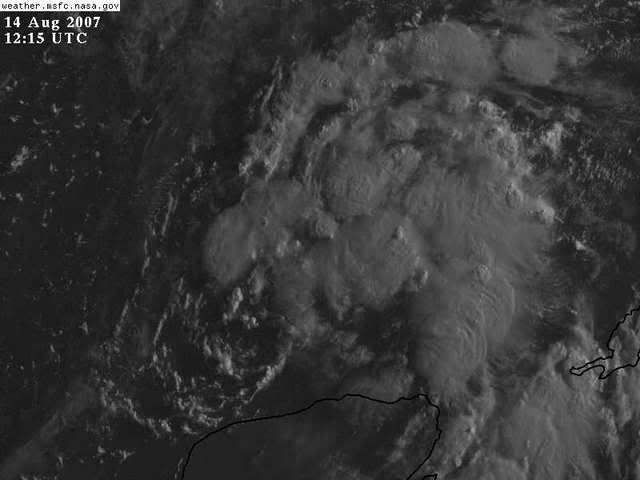
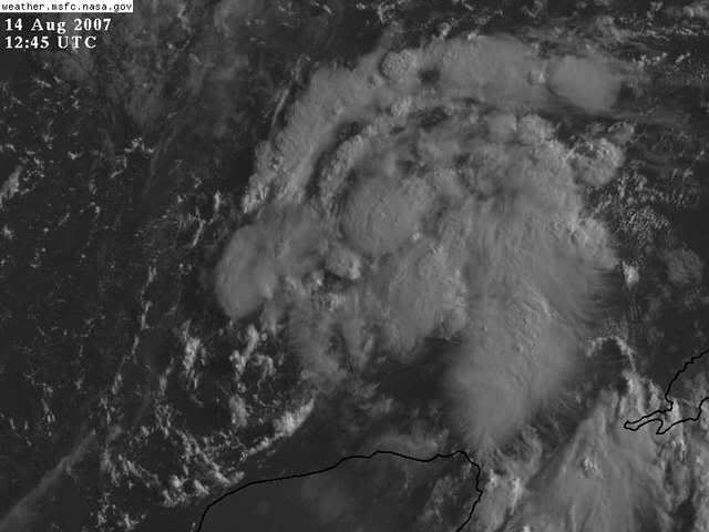
Since NOAA imagery has been out to lunch lately, here are some alternatives:
http://www.nrlmry.navy.mil/tcdat/tc07/A ... LATEST.jpg
http://adds.aviationweather.gov/satelli ... &itype=vis
http://hadar.cira.colostate.edu/ramsdis ... at2_0.html
http://www.meteo.psu.edu/~gadomski/SAT_ ... ntvis.html
http://www.nrlmry.navy.mil/tcdat/tc07/A ... LATEST.jpg
http://adds.aviationweather.gov/satelli ... &itype=vis
http://hadar.cira.colostate.edu/ramsdis ... at2_0.html
http://www.meteo.psu.edu/~gadomski/SAT_ ... ntvis.html
0 likes

Who is online
Users browsing this forum: No registered users and 13 guests