Myanmar / TC NARGIS (TC 01B) Update: 84,500 dead

Moderator: S2k Moderators

Message
Author
User avatar
Cyclenall
Category 5
Category 5
Posts: 6666
Joined: Thu Jun 08, 2006 10:01 pm
Location: Ontario, Canada

Re:

#201 Postby Cyclenall » Thu May 01, 2008 8:53 pm

Derek Ortt wrote:http://www.nrlmry.navy.mil/tc_pages/tc08/IO/01B.NARGIS/ssmi/85h/2degreeticks/full/Latest.html

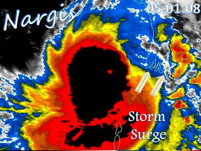
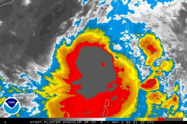
The eye is more than fine

This is likely an upper cat 4 or a lower cat 5, but due to the eye size, the IR is having a little trouble detecting the eye. It is surrounded by cloud top temps of <193K

How cleared out do you think the eye really is? It's doesn't look good on current images.
0 likes   

User avatar
HURAKAN
Professional-Met
Professional-Met
Posts: 46086
Age: 38
Joined: Thu May 20, 2004 4:34 pm
Location: Key West, FL
Contact:

#202 Postby HURAKAN » Thu May 01, 2008 9:10 pm

Image

Image

Eye becoming better defined.
0 likes   

User avatar
HURAKAN
Professional-Met
Professional-Met
Posts: 46086
Age: 38
Joined: Thu May 20, 2004 4:34 pm
Location: Key West, FL
Contact:

#203 Postby HURAKAN » Thu May 01, 2008 9:24 pm

Image
0 likes   

User avatar
Tampa Bay Hurricane
Category 5
Category 5
Posts: 5597
Age: 37
Joined: Fri Jul 22, 2005 7:54 pm
Location: St. Petersburg, FL

#204 Postby Tampa Bay Hurricane » Thu May 01, 2008 9:37 pm

Looks like 150-165 mph Maximum Winds- as Derek said High 4 or
low 5; the satellite is not resolved well- anyway the deep ring
of convection over a tiny eye and the convection is explosive.
0 likes   

User avatar
HURAKAN
Professional-Met
Professional-Met
Posts: 46086
Age: 38
Joined: Thu May 20, 2004 4:34 pm
Location: Key West, FL
Contact:

#205 Postby HURAKAN » Thu May 01, 2008 9:53 pm

:uarrow: I altered the intensity of the colors of the image above. Don't think it's that intense!!!

This is the real color.

Image
0 likes   

User avatar
Tampa Bay Hurricane
Category 5
Category 5
Posts: 5597
Age: 37
Joined: Fri Jul 22, 2005 7:54 pm
Location: St. Petersburg, FL

#206 Postby Tampa Bay Hurricane » Thu May 01, 2008 9:56 pm

Oh ok thanks Hurakan!
Looks like with the small eye about 145 mph but weakening
as dry air is intruding from the northeast quadrant.

It is hard to tell the intensity just from seeing satellite but
I think with what Derek said it is high.
But still it may be between 125-145 mph.
0 likes   

User avatar
HURAKAN
Professional-Met
Professional-Met
Posts: 46086
Age: 38
Joined: Thu May 20, 2004 4:34 pm
Location: Key West, FL
Contact:

#207 Postby HURAKAN » Thu May 01, 2008 9:58 pm

Image

Image

Eye becoming more clear.
0 likes   

ugaap
Tropical Depression
Tropical Depression
Posts: 72
Joined: Tue Apr 29, 2008 3:10 am
Location: India
Contact:

Re: Bay of Bengal: Very Severe Cyclonic Storm NARGIS (TC 01B)

#208 Postby ugaap » Thu May 01, 2008 10:00 pm

Estimated time for the Eye to hit Ayeyarwady Coast 0800 UTC around five hours from now
Last edited by ugaap on Fri May 02, 2008 12:19 am, edited 1 time in total.
0 likes   

User avatar
Chacor
Category 5
Category 5
Posts: 10229
Joined: Mon Oct 02, 2006 10:43 pm
Location: Singapore

Re: Bay of Bengal: Very Severe Cyclonic Storm NARGIS (TC 01B)

#209 Postby Chacor » Thu May 01, 2008 10:02 pm

IMD's forecast landfall is for evening/night, which would mean later (around 1200Z or later).
0 likes   

User avatar
HURAKAN
Professional-Met
Professional-Met
Posts: 46086
Age: 38
Joined: Thu May 20, 2004 4:34 pm
Location: Key West, FL
Contact:

#210 Postby HURAKAN » Thu May 01, 2008 10:06 pm

Image

Image

Even better now.

_________________________

02/0230 UTC 15.8N 93.2E T6.0/6.0 NARGIS -- Bay of Bengal
0 likes   

Derek Ortt

#211 Postby Derek Ortt » Thu May 01, 2008 10:06 pm

JTWC lowered the winds due to likely flawed Dvorak estimates. IMO, they are not exactly doing much better than IMD with this storm
0 likes   

User avatar
Chacor
Category 5
Category 5
Posts: 10229
Joined: Mon Oct 02, 2006 10:43 pm
Location: Singapore

#212 Postby Chacor » Thu May 01, 2008 10:23 pm

IMD's up to T4.5.
0 likes   

RL3AO
Moderator-Pro Met
Moderator-Pro Met
Posts: 16308
Joined: Thu Jun 14, 2007 10:03 pm
Location: NC

#213 Postby RL3AO » Thu May 01, 2008 10:29 pm

75 kts? What a joke.
0 likes   

User avatar
Chacor
Category 5
Category 5
Posts: 10229
Joined: Mon Oct 02, 2006 10:43 pm
Location: Singapore

Re:

#214 Postby Chacor » Thu May 01, 2008 10:32 pm

RL3AO wrote:75 kts? What a joke.


It had it at 75 kts T4.0 at 18z, so it's possible they're going higher.
0 likes   

User avatar
senorpepr
Military Met/Moderator
Posts: 12542
Age: 43
Joined: Fri Aug 22, 2003 9:22 pm
Location: Mackenbach, Germany
Contact:

#215 Postby senorpepr » Thu May 01, 2008 10:33 pm

FWIW...


UW - CIMSS
ADVANCED DVORAK TECHNIQUE
ADT-Version 7.2.1
Tropical Cyclone Intensity Algorithm

----- Current Analysis -----
Date : 02 MAY 2008 Time : 013000 UTC
Lat : 15:42:30 N Lon : 92:50:29 E


CI# /Pressure/ Vmax
3.8 / 979.2mb/ 61.0kt


6hr-Avg T# 3hr-Avg T# Adj T# Raw T#
3.7 3.7 4.0 4.0

Latitude bias adjustment to MSLP : +0.0mb

Center Temp : -75.3C Cloud Region Temp : -85.9C

Scene Type : UNIFORM CDO CLOUD REGION

Positioning Method : FORECAST INTERPOLATION

Ocean Basin : INDIAN
Dvorak CI > MSLP Conversion Used : PACIFIC

Tno/CI Rules : Constraint Limits : NO LIMIT
Weakening Flag : ON
Rapid Dissipation Flag : OFF
0 likes   

User avatar
HURAKAN
Professional-Met
Professional-Met
Posts: 46086
Age: 38
Joined: Thu May 20, 2004 4:34 pm
Location: Key West, FL
Contact:

Re: Bay of Bengal: Very Severe Cyclonic Storm NARGIS (TC 01B)

#216 Postby HURAKAN » Thu May 01, 2008 10:39 pm

Image

Image

Eye continues to become more clear and defined.
0 likes   

User avatar
Chacor
Category 5
Category 5
Posts: 10229
Joined: Mon Oct 02, 2006 10:43 pm
Location: Singapore

#217 Postby Chacor » Thu May 01, 2008 10:40 pm

Probably not as clear as you think. Still pretty cloudy on IR.
0 likes   

User avatar
HURAKAN
Professional-Met
Professional-Met
Posts: 46086
Age: 38
Joined: Thu May 20, 2004 4:34 pm
Location: Key West, FL
Contact:

Re: Bay of Bengal: Very Severe Cyclonic Storm NARGIS (TC 01B)

#218 Postby HURAKAN » Thu May 01, 2008 10:47 pm

Image

Image

Image
0 likes   

User avatar
Chacor
Category 5
Category 5
Posts: 10229
Joined: Mon Oct 02, 2006 10:43 pm
Location: Singapore

#219 Postby Chacor » Thu May 01, 2008 10:48 pm

FKIN20 VIDP 020340

DTG: 20080502/0000Z
TCAC: NEW DELHI
TC: NARGIS
NR: 17

PSN: N1600 E09230
MOV: E10KT
C: 972 HPA

MAX WIND: 80KT GUSTING TO 90KT

FCST PSN+ 12 HRS: 021200 N1630 E09400
MAX WIND+12 HRS: 9OKT

FCST PSN +18HRS: OVER LAND

NEXT MSG: 20080502/0600Z

-----
0 likes   

ugaap
Tropical Depression
Tropical Depression
Posts: 72
Joined: Tue Apr 29, 2008 3:10 am
Location: India
Contact:

Re: Bay of Bengal: Very Severe Cyclonic Storm NARGIS (TC 01B)

#220 Postby ugaap » Thu May 01, 2008 10:54 pm

Chacor wrote:IMD's forecast landfall is for evening/night, which would mean later (around 1200Z or later).


IMD is the official agency monitoring this Storm but their Bulletins/Advisories comeout after the event happens. They are yet talking of landfall around 17N. The Eye of Nargis is currently located at 15.8N 93.4E which is just 1.1 Degree to landfall (Approximatey 120 Kms.)
0 likes   


Return to “2008”

Who is online

Users browsing this forum: No registered users and 6 guests