TC Bertha
Moderator: S2k Moderators
-
Stormavoider
- Category 2

- Posts: 671
- Joined: Sat Jul 01, 2006 4:37 pm
- Location: Spring Hill Fl.
Re: Hurricane Bertha in Central Atlantic
Bertha seems to be moving almost due north over the last few frames.
0 likes

If it gets that high deltadog03 it would be very impressive, indeed it would quite possibly be up there with some of the strongest July hurricanes. Right now its got to strenghen more to get that title as its only a low end cat-3 BUT with a central pressure of 948mbs its got to be close to the top 10 storngest July storms ever, if not in it already?
0 likes
-
cheezyWXguy

- Category 5

- Posts: 6282
- Joined: Mon Feb 13, 2006 12:29 am
- Location: Dallas, TX
Re: Hurricane Bertha in Central Atlantic
Stormavoider wrote:Bertha seems to be moving almost due north over the last few frames.
yeah..should continue for another 6 hours or so...although I think despite the northward movement, higher than the current forecast position, it should begin to even out to a more westward movement, coming directly at, or just to the north of, the next forecast point.
I wonder how strong bertha currently is...
0 likes
-
Mecklenburg
Re: Hurricane Bertha in Central Atlantic
could bertha manage to pull off a cat 4 on the next advisory?... this season is beginning to get interesting
0 likes
-
Mecklenburg
Re: Hurricane Bertha in Central Atlantic
bertha really did made a shocker this early in the season
0 likes
-
CrazyC83
- Professional-Met

- Posts: 34315
- Joined: Tue Mar 07, 2006 11:57 pm
- Location: Deep South, for the first time!
Re:
KWT wrote:Hmm all depends on what the Sat.estimates are for this system as they are all we've really got with no recon being out there.
Probably they'll need consensus T6.0 to go there.
0 likes
-
MiamiensisWx
Re: Hurricane Bertha in Central Atlantic
Based on trends and analysis, it appears that the northward movement is permanent. Bertha will likely recurve slowly and pass well east of Bermuda in the wake of the TUTT.
http://www.ssd.noaa.gov/goes/east/tatl/loop-vis.html
My forecasts for a track along the western perimeter of the cone and model guidance will be a significant bust; in fact, it is recurving east of the guidance!
http://www.ssd.noaa.gov/goes/east/tatl/loop-vis.html
My forecasts for a track along the western perimeter of the cone and model guidance will be a significant bust; in fact, it is recurving east of the guidance!
Last edited by MiamiensisWx on Mon Jul 07, 2008 6:40 pm, edited 1 time in total.
0 likes
-
Mecklenburg
Re: Hurricane Bertha in Central Atlantic
the cape verde season awakens from it's slumber in 2005, 2006 and 2007
0 likes
-
JonathanBelles
- Professional-Met
- Posts: 11430
- Age: 35
- Joined: Sat Dec 24, 2005 9:00 pm
- Location: School: Florida State University (Tallahassee, FL) Home: St. Petersburg, Florida
- Contact:
Re: Hurricane Bertha in Central Atlantic
The posts in this forum are NOT official forecast and should not be used as such. They are just the opinion of the poster and may or may not be backed by sound meteorological data. They are NOT endorsed by any professional institution or storm2k.org. For official information, please refer to the NHC and NWS products.
Advisory 070708 update
Hurricane Bertha has been upgraded to Major Hurricane Bertha.
No graphic at this time.
Central Atlantic....Major Hurricane Bertha. Hurricane Bertha has skipped over the category 2 status surprisingly and has become a Major Hurricane. Bertha's eye has continued to clear. I think that it is accurate to say Bertha has continued to strengthen up to 120mph. I dont see Bertha weakening or peaking in the next 6 hours. Category 4 may very well be in the cards.
No track change at this time, but will likely be changed at my next update. Bermuda needs to prepare now for a possible category 4.
It would be great if we could see what Bertha's real intensity is. At the moment I feel that it is being underestimated.
Fact789-Jonathan
0 likes
-
JonathanBelles
- Professional-Met
- Posts: 11430
- Age: 35
- Joined: Sat Dec 24, 2005 9:00 pm
- Location: School: Florida State University (Tallahassee, FL) Home: St. Petersburg, Florida
- Contact:
Re: Hurricane Bertha in Central Atlantic
Mecklenburg wrote:the cape verde season awakens from it's slumber in 2005, 2006 and 2007
\
Big Bertha earns her name!
0 likes
Re: Hurricane Bertha in Central Atlantic
miami you are jumping the gun and i'm surprised at this type of post from you
the steering flow (200-700) clearly showed a NW movement even more than 315 degrees until either 22.5 N latitude or 52.5 longitude and after that bent to the west, this current movement does not mean the system will not move westward tomorrow and bermuda may very well be effected
the steering flow (200-700) clearly showed a NW movement even more than 315 degrees until either 22.5 N latitude or 52.5 longitude and after that bent to the west, this current movement does not mean the system will not move westward tomorrow and bermuda may very well be effected
Last edited by cpdaman on Mon Jul 07, 2008 6:43 pm, edited 1 time in total.
0 likes
-
weatherman21

- Tropical Depression

- Posts: 67
- Joined: Mon Apr 23, 2007 11:07 am
Re: Hurricane Bertha in Central Atlantic
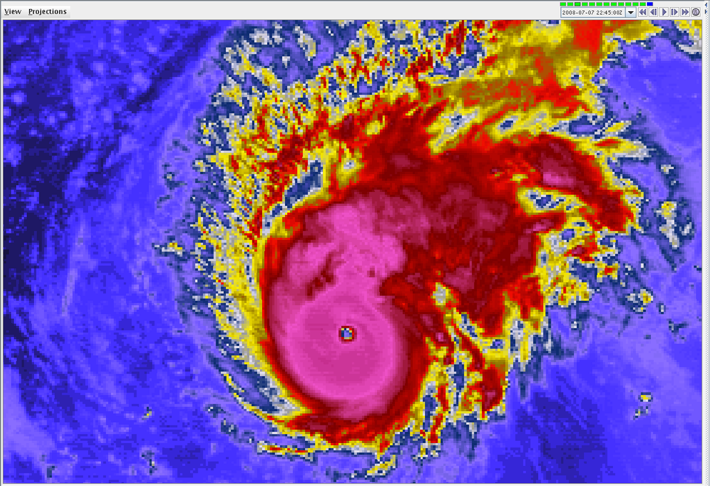
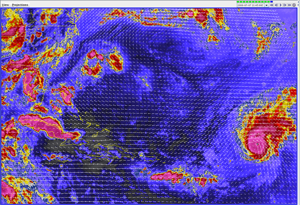
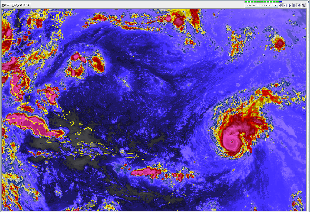
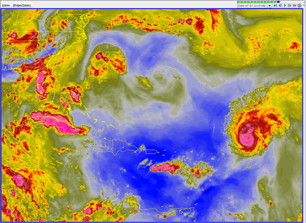
A few images from the Integrated Data Viewer:
GOES Close Infrared Satellite:
GOES Infrared Satellite with 1000MB Winds from GFS 18Z Initialization:
GOES Infrared Satellite:
GOES Water Vapor:
GOES Close Infrared Satellite:
GOES Infrared Satellite with 1000MB Winds from GFS 18Z Initialization:
GOES Infrared Satellite:
GOES Water Vapor:
0 likes
-
Stratosphere747
- Category 5
- Posts: 3772
- Joined: Thu Sep 11, 2003 8:34 pm
- Location: Surfside Beach/Freeport Tx
- Contact:
-
MiamiensisWx
Re:
KWT wrote:Npot so fast MiamiensisWx the weakness is now moving away and the upper high will start to effect it soon. The GFDL does show the recurve starting now though so I'm not going to dismiss that but equally it may just be a breif movement towards the weakness before it gets shunted back WNW.
WV suggests that a slow recurvature is occurring now:
http://www.ssd.noaa.gov/goes/east/tatl/loop-wv.html
It's encountering the upper level weakness and gradually moving north. Although the ridging will move east over the next few days, it will be weaker, so it won't halt a long term recurvature. The evidence has become too convincing now.
Last edited by MiamiensisWx on Mon Jul 07, 2008 6:47 pm, edited 1 time in total.
0 likes
-
brunota2003

- S2K Supporter

- Posts: 9476
- Age: 35
- Joined: Sat Jul 30, 2005 9:56 pm
- Location: Stanton, KY...formerly Havelock, NC
- Contact:
Re: Re:
MiamiensisWx wrote:KWT wrote:Npot so fast MiamiensisWx the weakness is now moving away and the upper high will start to effect it soon. The GFDL does show the recurve starting now though so I'm not going to dismiss that but equally it may just be a breif movement towards the weakness before it gets shunted back WNW.
WV suggests that a slow recurvature is occurring now:
http://www.ssd.noaa.gov/goes/east/tatl/loop-wv.html
Steering currents suggest that it is about to turn back towards the wnw/w too.
0 likes
Stratosphere747, nope he clearly states its going to go east of model concensus, in other words its recurving already.
IMO there clearly is NW movement right now probably around 310 I'd guess, though this is probably just a fling towards the weakness. If it can gain enough latitude then as its a very deep storm now its not impossible for it to get picked up here and now but it should be able to escape this first weakness if it carries on slowly.
IMO there clearly is NW movement right now probably around 310 I'd guess, though this is probably just a fling towards the weakness. If it can gain enough latitude then as its a very deep storm now its not impossible for it to get picked up here and now but it should be able to escape this first weakness if it carries on slowly.
0 likes

-
weatherman21
- Tropical Depression
- Posts: 67
- Joined: Mon Apr 23, 2007 11:07 am

Who is online
Users browsing this forum: No registered users and 15 guests