ATL: Tropical Storm Kyle : Discussion

Moderator: S2k Moderators

Message
Author
User avatar
Hurricaneman
Category 5
Category 5
Posts: 7351
Age: 45
Joined: Tue Aug 31, 2004 3:24 pm
Location: central florida

Re: ATL INVEST 93L: Discussion

#521 Postby Hurricaneman » Mon Sep 22, 2008 1:42 pm

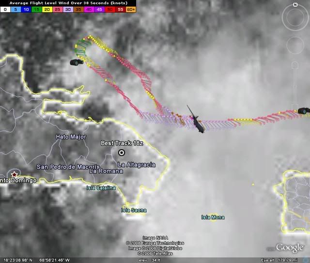
vacanechaser wrote:anyone looked at radar...?? i see the low level center wher nhc says it is.. but a small tight vigerous spin is due south of ponce!! look for yourselves.. this could be redeveloping under what appears to be a mid level circulation... not saying it will, could.... pretty vigerous little spin there


http://radar.weather.gov/radar.php?rid=JUA&product=N0Z&overlay=11111111&loop=yes


Jesse V. Bass III
http://www.vastormphoto.com
Hurricane Intercept Research Team


I think there are two areas of low pressure, one off the northeast tip of the DR and one just south of PR near Ponce
0 likes   

Ed Mahmoud

Re: ATL INVEST 93L: Discussion

#522 Postby Ed Mahmoud » Mon Sep 22, 2008 1:46 pm

I see stronger echoes moving from the South, while lighter echoes in the same area moving from the West-Northwest. Or, probably a very poorly stacked system.

Image
0 likes   

User avatar
BensonTCwatcher
Category 5
Category 5
Posts: 1046
Joined: Sat Aug 28, 2004 10:11 pm
Location: Southport NC

#523 Postby BensonTCwatcher » Mon Sep 22, 2008 1:48 pm

The one over DR is the closest to being a true LLC (check wind obs) and it looks to be trying to develp some convection BUT the synoptics look to be tee'd up for shear for as far out as I can see. If this thing pinballs around a developing high (not seen on GFS by the way) and the ULL's it could have a snowball's chance if you get my meaning :D If it does take off it will have to pull fast one or bide it's time past 36 hours or more. Just the opinion of the poster 8-)
0 likes   

User avatar
vbhoutex
Storm2k Executive
Storm2k Executive
Posts: 29112
Age: 73
Joined: Wed Oct 09, 2002 11:31 pm
Location: Cypress, TX
Contact:

Re: ATL INVEST 93L: Discussion

#524 Postby vbhoutex » Mon Sep 22, 2008 1:49 pm

I only see the one in the Mona passage. It is very obvious. If there is another one I don't see it. I do see storms growing and then tops warming in the area you are talking about and even some of the curving I think you are seeing, but I don't think it is a low center at any level. I do see what I would consider outflow boundaries heading north from that area.
0 likes   

User avatar
cycloneye
Admin
Admin
Posts: 145322
Age: 68
Joined: Thu Oct 10, 2002 10:54 am
Location: San Juan, Puerto Rico

Re: ATL INVEST 93L: Discussion

#525 Postby cycloneye » Mon Sep 22, 2008 1:51 pm

18:00 UTC Best track.

AL, 93, 2008092218, , BEST, 0, 187N, 688W, 30, 1009, DB,
0 likes   

User avatar
Cyclenall
Category 5
Category 5
Posts: 6666
Joined: Thu Jun 08, 2006 10:01 pm
Location: Ontario, Canada

#526 Postby Cyclenall » Mon Sep 22, 2008 1:52 pm

Hopefully it becomes a named storm (Kyle) tomorrow so my prediction is spot on (exact) in the "When is Kyle going to form" thread.

Frank2 wrote:I think everyone will be very happy at this point if it just poofs out, for sure...

Not everyone, see above.

Frank2 wrote:Steve,

Too early to say if it'll dissipate, however, the conditions are becoming less and less favorable as we get closer to October (more shear and troughs, but, less of a ridge than just two or three weeks ago) - per the chilly temps up north the past few days, it's looking like an early or seasonally "on-time" end to the hurricane season this year, thankfully...

There is a secondary peak in October so conditions becoming less and less favorable isn't a good way to put it. This is not an end to the hurricane season.

Frank2 wrote:Even if 93L does form into something significant, the EC trough is certainly strong enough to keep it offshore, for sure (pardon the "sounds like" double entendre)...

For sure? More like unlikely. The models aren't favoring that solution.
0 likes   

User avatar
BensonTCwatcher
Category 5
Category 5
Posts: 1046
Joined: Sat Aug 28, 2004 10:11 pm
Location: Southport NC

Re: ATL INVEST 93L: Discussion

#527 Postby BensonTCwatcher » Mon Sep 22, 2008 1:53 pm

cycloneye wrote:18:00 UTC Best track.

AL, 93, 2008092218, , BEST, 0, 187N, 688W, 30, 1009, DB,


That's about where I see it maybe even a little bit east of there based on visibles and wind obs
0 likes   

User avatar
HURAKAN
Professional-Met
Professional-Met
Posts: 46086
Age: 38
Joined: Thu May 20, 2004 4:34 pm
Location: Key West, FL
Contact:

#528 Postby HURAKAN » Mon Sep 22, 2008 1:54 pm

Image
0 likes   

User avatar
cycloneye
Admin
Admin
Posts: 145322
Age: 68
Joined: Thu Oct 10, 2002 10:54 am
Location: San Juan, Puerto Rico

Re: ATL INVEST 93L: Discussion

#529 Postby cycloneye » Mon Sep 22, 2008 1:56 pm

SSD Dvorak almost coincides with best track.

22/1745 UTC 18.7N 68.6W OVERLAND 93L -- Atlantic Ocean
0 likes   

User avatar
HURAKAN
Professional-Met
Professional-Met
Posts: 46086
Age: 38
Joined: Thu May 20, 2004 4:34 pm
Location: Key West, FL
Contact:

#530 Postby HURAKAN » Mon Sep 22, 2008 2:03 pm

Loop: http://rammb.cira.colostate.edu/product ... 152115.GIF

The loop clearly shows the circulation.
0 likes   

User avatar
HURAKAN
Professional-Met
Professional-Met
Posts: 46086
Age: 38
Joined: Thu May 20, 2004 4:34 pm
Location: Key West, FL
Contact:

#531 Postby HURAKAN » Mon Sep 22, 2008 2:07 pm

Image

Image
0 likes   

User avatar
caribepr
Category 5
Category 5
Posts: 1794
Joined: Fri Sep 05, 2003 10:43 pm
Location: Culebra, PR 18.33 65.33

Re:

#532 Postby caribepr » Mon Sep 22, 2008 2:10 pm

Cyclenall wrote:Hopefully it becomes a named storm (Kyle) tomorrow so my prediction is spot on (exact) in the "When is Kyle going to form" thread.

Frank2 wrote:I think everyone will be very happy at this point if it just poofs out, for sure...

Not everyone, see above.


Nice to be in Canada and hope it develops so you can have a spot on prediction...sheesh! :roll:
0 likes   

User avatar
HURAKAN
Professional-Met
Professional-Met
Posts: 46086
Age: 38
Joined: Thu May 20, 2004 4:34 pm
Location: Key West, FL
Contact:

#533 Postby HURAKAN » Mon Sep 22, 2008 2:13 pm

Image

There is the LLC and appears to be moving towards the coast.
0 likes   

Ed Mahmoud

Re: ATL INVEST 93L: Discussion

#534 Postby Ed Mahmoud » Mon Sep 22, 2008 2:16 pm

There may be a little surface spin on the Eastern tip of the DR, but looking at the satellite and radar, this is a disorganized mess, and being that the surface spin is moving overland, and the heaviest storms are sheared/displaced well to the East and Southeast, I'd say that isn't the center that becomes the real Kyle. IMHO.
0 likes   

storm4u
Category 2
Category 2
Posts: 651
Joined: Wed Aug 11, 2004 7:26 am
Location: agawam, ma
Contact:

Re: ATL INVEST 93L: Discussion

#535 Postby storm4u » Mon Sep 22, 2008 2:23 pm

This is starting to make me a little nervous. Alot of the models are starting to show a northeast hit. I know that things can change and we dont even have a system really yet but I dont like the looks of this one! For now though for what could be a kyle in a couple of days doent look to good but it still has me on edge!
0 likes   

Ed Mahmoud

Re: ATL INVEST 93L: Discussion

#536 Postby Ed Mahmoud » Mon Sep 22, 2008 2:25 pm

I see 93L has a few storms popping near the surface center now, but that may be a result of upslope flow into the mountains. I think, unofficially, that center is stillborn, and 93L either never develops, or a new center forms well South, down between 16 and 17ºN, under the deepest thunderstorms.


Unofficially, in my humble and amateur opinion.

Only way DR center survives is if it quickly gets North of land. But shear increases to the North, so I am not at all sure it has a future.
0 likes   

HurricaneFreak

Re: ATL INVEST 93L: Discussion

#537 Postby HurricaneFreak » Mon Sep 22, 2008 2:34 pm

Yeah this is not going to be the last storm were getting cause we have 2 full months left and Wilma came in October.It appears this is moving NW instead of a NNW direction
0 likes   

User avatar
bvigal
S2K Supporter
S2K Supporter
Posts: 2276
Joined: Sun Jul 24, 2005 8:49 am
Location: British Virgin Islands
Contact:

Re: Re:

#538 Postby bvigal » Mon Sep 22, 2008 2:41 pm

caribepr wrote:
Cyclenall wrote:Hopefully it becomes a named storm (Kyle) tomorrow so my prediction is spot on (exact) in the "When is Kyle going to form" thread.

Frank2 wrote:I think everyone will be very happy at this point if it just poofs out, for sure...

Not everyone, see above.


Nice to be in Canada and hope it develops so you can have a spot on prediction...sheesh! :roll:

My sentiment exactly! What's a bit stronger storm and a few more deaths matter, if one's ego can be stroked by 'being right'? :double:
0 likes   

Ed Mahmoud

Re: ATL INVEST 93L: Discussion

#539 Postby Ed Mahmoud » Mon Sep 22, 2008 2:44 pm

18ºN and 69ºW, about a 1008 mb center by recon, but I don't think this lasts. IMHO.


ETA:

I wish recon would wander South, down around 16º or 17º, to see if a new and improved center is trying to form...
0 likes   

Sanibel
Category 5
Category 5
Posts: 10375
Joined: Mon Aug 30, 2004 11:06 pm
Location: Offshore SW Florida

Re: ATL INVEST 93L: Discussion

#540 Postby Sanibel » Mon Sep 22, 2008 2:57 pm

Can't tell which is the real center. Mona Passage center has more deep convection. Headed right towards land. Mid center is definitely north of Hispaniola and headed W of NW.

Shear will prevent any strengthening.

Storm looks better and more active on visible.
0 likes   


Return to “2008”

Who is online

Users browsing this forum: Majestic-12 [Bot] and 15 guests