WPAC : TROPICAL DEPRESSION PARMA (19W)
Moderator: S2k Moderators
-
cycloneye

- Admin

- Posts: 149275
- Age: 69
- Joined: Thu Oct 10, 2002 10:54 am
- Location: San Juan, Puerto Rico
Re: WPAC : TYPHOON PARMA (19W)
0 likes
Visit the Caribbean-Central America Weather Thread where you can find at first post web cams,radars
and observations from Caribbean basin members Click Here
and observations from Caribbean basin members Click Here
-
brunota2003

- S2K Supporter

- Posts: 9476
- Age: 35
- Joined: Sat Jul 30, 2005 9:56 pm
- Location: Stanton, KY...formerly Havelock, NC
- Contact:


-
Derek Ortt

Re: WPAC : TYPHOON PARMA (19W)
I'm very worried about the possibility of Parma stalling on Philippines after what happened with Ketsana, also I have a friend on Taiwan I think I should warn him about Parma.
0 likes
-
Squarethecircle
- Category 5

- Posts: 2165
- Joined: Fri Oct 19, 2007 4:00 pm
- Location: Fairfax, VA
Re: WPAC : TYPHOON PARMA (19W)
First vis out:

Quite impressive.
Also:
CI# /Pressure/ Vmax
5.8 / 936.4mb/109.8kt
Final T# Adj T# Raw T#
(3hr avg)
5.8 6.8 7.3
Latitude bias adjustment to MSLP : +3.8mb
Estimated radius of max. wind based on IR :N/A km
Center Temp : -12.9C Cloud Region Temp : -82.3C
Quite impressive.
Also:
CI# /Pressure/ Vmax
5.8 / 936.4mb/109.8kt
Final T# Adj T# Raw T#
(3hr avg)
5.8 6.8 7.3
Latitude bias adjustment to MSLP : +3.8mb
Estimated radius of max. wind based on IR :N/A km
Center Temp : -12.9C Cloud Region Temp : -82.3C
0 likes

-
cycloneye
- Admin
- Posts: 149275
- Age: 69
- Joined: Thu Oct 10, 2002 10:54 am
- Location: San Juan, Puerto Rico
Re: WPAC : TYPHOON PARMA (19W)
30/2030 UTC 11.5N 131.7E T6.5/6.5 PARMA -- West Pacific
That is intensity of 127kts. http://www.ssd.noaa.gov/PS/TROP/CI-chart.html
That is intensity of 127kts. http://www.ssd.noaa.gov/PS/TROP/CI-chart.html
0 likes
Visit the Caribbean-Central America Weather Thread where you can find at first post web cams,radars
and observations from Caribbean basin members Click Here
and observations from Caribbean basin members Click Here
-
brunota2003
- S2K Supporter
- Posts: 9476
- Age: 35
- Joined: Sat Jul 30, 2005 9:56 pm
- Location: Stanton, KY...formerly Havelock, NC
- Contact:

-
Squarethecircle
- Category 5
- Posts: 2165
- Joined: Fri Oct 19, 2007 4:00 pm
- Location: Fairfax, VA
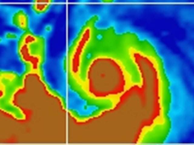
 Parma:
-
brunota2003
- S2K Supporter
- Posts: 9476
- Age: 35
- Joined: Sat Jul 30, 2005 9:56 pm
- Location: Stanton, KY...formerly Havelock, NC
- Contact:
-
somethingfunny

- ChatStaff

- Posts: 3926
- Age: 37
- Joined: Thu May 31, 2007 10:30 pm
- Location: McKinney, Texas
Re: WPAC : TYPHOON PARMA (19W)
That's a strange looking typhoon. I mean, the eye is miniscule and I believe it's very powerful...but the structure doesn't look right at all. It's lopsided and appears to only have one decent outflow channel. Compared to the bottom busters I'm used to seeing in the Atlantic, or even to Jimena or Choi-Wan, this storm doesn't look especially healthy. Is there some shear in the vicinity or a dry slot off to the storm's east? I certainly hope this thing collapses as quickly as it's intensified.
0 likes
-
StormingB81

- S2K Supporter
- Posts: 5676
- Age: 44
- Joined: Thu Aug 27, 2009 1:45 am
- Location: Rockledge, Florida
-
Squarethecircle
- Category 5
- Posts: 2165
- Joined: Fri Oct 19, 2007 4:00 pm
- Location: Fairfax, VA

-
wxmann_91

- Category 5
- Posts: 8007
- Age: 34
- Joined: Fri Jul 15, 2005 2:49 pm
- Location: Southern California
- Contact:
It's too bad there's no recon out there. They would easily find something ~900mb in there (you know, with the -90C ring of cloud tops, the pinhole eye...). Should be bottoming out right now as an ERC should begin soon.
Another thing, the deep layer ridging seems to be stronger than what models progged. I think this will make landfall in northern Luzon in about 36-48 hr, despite what the agencies forecast.
Another thing, the deep layer ridging seems to be stronger than what models progged. I think this will make landfall in northern Luzon in about 36-48 hr, despite what the agencies forecast.
0 likes
-
StormingB81
- S2K Supporter
- Posts: 5676
- Age: 44
- Joined: Thu Aug 27, 2009 1:45 am
- Location: Rockledge, Florida
Who is online
Users browsing this forum: No registered users and 34 guests