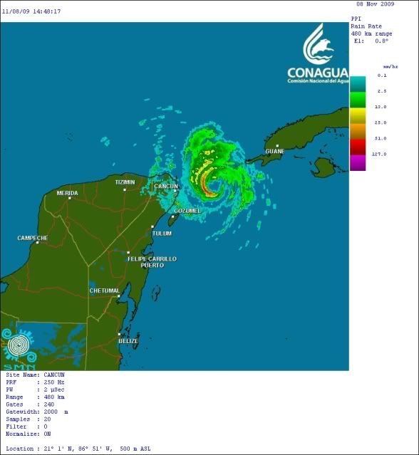
wxman57 wrote:I think Ida's about peaked in intensity now. Cloud tops are starting to warm. Latest model guidance puts what's left of Ida on the Gulf Coast Monday night. At that point it will be embedded in the jet core along the cold front. Moisture will be stripped off north of the center during the day Monday, so there won't be much to make "landfall" on the Gulf Coast. Ida will merge with the frontal low Tuesday morning and the whole mess will become a big Nor'easter Wednesday night/Thursday.
I just don't buy that hooking track to the southeast. I don't think there will be anything left of Ida to do that. Fewer models are showing the hook, and I suspect the NHC will give up on it soon.
The posts in this forum are NOT official forecast and should not be used as such. They are just the opinion of the poster and may or may not be backed by sound meteorological data. They are NOT endorsed by any professional institution or storm2k.org. For official information, please refer to the NHC and NWS products.
Yeah I agree with this forecast. In fact I think its starting the process of getting that large "comma" shape as it now starts to gain more lattitude and wind shear begins to increase from here on out. Should be a sheared mess by the time it reaches the Northern GOM and likely absorbed into the front and ejected NE. In fact probably won't be too tropical in the Northern GOM at all, more of a winter-like system. There will be some good winds, but mostly because of tight pressure gradients and not because of any "eye-wall" or hurricane-induced winds. The majority of the strongest winds will stay well offshore the Panhandle and Northern Gulf coast.