ATL: TROPICAL DEPRESSION ANA (02L)

Moderator: S2k Moderators

Message
Author
User avatar
cycloneye
Admin
Admin
Posts: 139593
Age: 67
Joined: Thu Oct 10, 2002 10:54 am
Location: San Juan, Puerto Rico

Re: ATL : INVEST 99L

#61 Postby cycloneye » Sun Aug 09, 2009 10:36 am

NHC may go with code red at 2 PM TWO.

Image

http://www.nhc.noaa.gov/tafb_latest/dan ... testBW.gif
0 likes   

Cyclone1
Category 5
Category 5
Posts: 2739
Age: 32
Joined: Tue Jun 12, 2007 12:03 pm
Location: Florida

#62 Postby Cyclone1 » Sun Aug 09, 2009 10:41 am

Funny how we've been following the blobs for weeks at a time, and then this little lady rolls off of Africa and immediately starts developing.

I'm watching.
0 likes   

User avatar
hurricanetrack
HurricaneTrack.com
HurricaneTrack.com
Posts: 1776
Joined: Tue Dec 02, 2003 10:46 pm
Location: Wilmington, NC
Contact:

#63 Postby hurricanetrack » Sun Aug 09, 2009 10:41 am

So in Dr. Masters' update, he mentions the SAL possibly playing a role here in a day or two, if that is the case and this does not develop quickly, then it would not be as susceptible to turning out to sea. Still, 12.5 north this early is kind of up there. Anyone want to throw together some stats on other TCs that had a similar lat at their genesis this far east and where they ended up?
0 likes   

User avatar
Jevo
S2K Supporter
S2K Supporter
Posts: 1729
Age: 46
Joined: Tue Aug 03, 2004 8:45 pm
Location: The Flemish Cap
Contact:

Re: ATL : INVEST 99L

#64 Postby Jevo » Sun Aug 09, 2009 10:43 am

I would definitly say this

Image

Bears Watching

hahah i had to do it.... lord knows there have not been enough opportunities this season
0 likes   

User avatar
HURAKAN
Professional-Met
Professional-Met
Posts: 46086
Age: 37
Joined: Thu May 20, 2004 4:34 pm
Location: Key West, FL
Contact:

#65 Postby HURAKAN » Sun Aug 09, 2009 11:07 am

Image

The train is ready to depart
0 likes   

User avatar
HURAKAN
Professional-Met
Professional-Met
Posts: 46086
Age: 37
Joined: Thu May 20, 2004 4:34 pm
Location: Key West, FL
Contact:

#66 Postby HURAKAN » Sun Aug 09, 2009 11:21 am

Image

Latest
0 likes   

User avatar
BigA
Professional-Met
Professional-Met
Posts: 1317
Joined: Sun Jul 24, 2005 10:56 pm

Re: ATL : INVEST 99L

#67 Postby BigA » Sun Aug 09, 2009 11:25 am

Nice Proto CDO, with what looks like another blowup of white (high) cloud tops near the center.
0 likes   

User avatar
SEASON_CANCELED
Category 3
Category 3
Posts: 887
Joined: Mon Jul 06, 2009 5:17 am
Location: 8 Bit Charlie Sheen

Re:

#68 Postby SEASON_CANCELED » Sun Aug 09, 2009 11:26 am

HURAKAN wrote:Image

The train is ready to depart


:double: looks like we will busy 2 weeks from now. i think september will be pretty violent aswell. Alot of that energy from the pacific will have made its way back over to africa in mid september.
0 likes   

User avatar
HURAKAN
Professional-Met
Professional-Met
Posts: 46086
Age: 37
Joined: Thu May 20, 2004 4:34 pm
Location: Key West, FL
Contact:

#69 Postby HURAKAN » Sun Aug 09, 2009 11:37 am

Image

For anyone interested this link updates every 15 minutes: http://oiswww.eumetsat.org/IPPS/html/la ... Africa.jpg
0 likes   

User avatar
cycloneye
Admin
Admin
Posts: 139593
Age: 67
Joined: Thu Oct 10, 2002 10:54 am
Location: San Juan, Puerto Rico

Re: ATL : INVEST 99L

#70 Postby cycloneye » Sun Aug 09, 2009 11:40 am

Good closeup visible image.I smell code red at 2 PM.

Image
0 likes   

User avatar
vbhoutex
Storm2k Executive
Storm2k Executive
Posts: 28979
Age: 72
Joined: Wed Oct 09, 2002 11:31 pm
Location: Spring Branch area, Houston, TX
Contact:

Re:

#71 Postby vbhoutex » Sun Aug 09, 2009 11:44 am

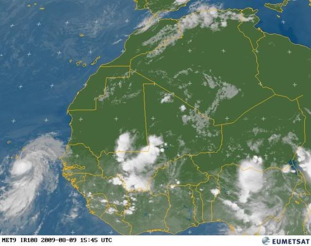
hurricanetrack wrote:So in Dr. Masters' update, he mentions the SAL possibly playing a role here in a day or two, if that is the case and this does not develop quickly, then it would not be as susceptible to turning out to sea. Still, 12.5 north this early is kind of up there. Anyone want to throw together some stats on other TCs that had a similar lat at their genesis this far east and where they ended up?

Maybe my skills(??) are a little rusty, but that seems about the right latitude to me for this time of year-maybe a few weeks early. Now if we're talking it making the Caribbean from that point that would definitely normally make it too high in latitude that far out.
I haven't even looked at the synoptics, etc. on this one yet, but am surprised at how it has held together and developed. Definitely going to be in all ATL basin TC watchers sights for a while.
0 likes   

User avatar
dixiebreeze
S2K Supporter
S2K Supporter
Posts: 5140
Joined: Wed Sep 03, 2003 5:07 pm
Location: crystal river, fla.

Re: ATL : INVEST 99L

#72 Postby dixiebreeze » Sun Aug 09, 2009 11:51 am

09/1330 UTC 14.2N 21.8W T1.5/1.5 99L -- Atlantic
0 likes   

Brent
S2K Supporter
S2K Supporter
Posts: 37143
Age: 35
Joined: Sun May 16, 2004 10:30 pm
Location: Tulsa Oklahoma
Contact:

Re:

#73 Postby Brent » Sun Aug 09, 2009 11:52 am

HURAKAN wrote:Image

The train is ready to depart


Now we're talking. :cheesy:

Fully expect this to be a TD by the end of the day.
0 likes   

User avatar
KWT
Category 5
Category 5
Posts: 31391
Joined: Tue Aug 17, 2004 11:02 am
Location: UK!!!

#74 Postby KWT » Sun Aug 09, 2009 11:52 am

They may hold orange because seems like the convection has become a touch more shallow recently and less coverage, but equally they could go red because it has got a very good structure.
0 likes   

User avatar
cycloneye
Admin
Admin
Posts: 139593
Age: 67
Joined: Thu Oct 10, 2002 10:54 am
Location: San Juan, Puerto Rico

Re: ATL: Invest 99L Models

#75 Postby cycloneye » Sun Aug 09, 2009 11:54 am

Off topic=Go to the models thread at talking tropics forum to see what the wave that will emerge Africa in 3 days does according to the long range GFS.
0 likes   

User avatar
cycloneye
Admin
Admin
Posts: 139593
Age: 67
Joined: Thu Oct 10, 2002 10:54 am
Location: San Juan, Puerto Rico

Re: ATL : INVEST 99L

#76 Postby cycloneye » Sun Aug 09, 2009 12:11 pm

Looking more and more impressive as time goes on.

Image
0 likes   

User avatar
cycloneye
Admin
Admin
Posts: 139593
Age: 67
Joined: Thu Oct 10, 2002 10:54 am
Location: San Juan, Puerto Rico

Re: ATL: Invest 99L Models

#77 Postby cycloneye » Sun Aug 09, 2009 12:13 pm

12z CMC takes 99L on a westward track.

http://moe.met.fsu.edu/cgi-bin/cmctc2.c ... =Animation

Image
0 likes   

Aric Dunn
Category 5
Category 5
Posts: 21228
Age: 41
Joined: Sun Sep 19, 2004 9:58 pm
Location: Ready for the Chase.
Contact:

#78 Postby Aric Dunn » Sun Aug 09, 2009 12:16 pm

I still see a linear cloud feature, probably the itcz that extends westward from the area which tells me that at the surface we dont quite have a closed circ. but the convection is doing what would be typical of a system. its pulsing up and down as it seemingly is warping around some sort of a center. very impressive midlevel circ though, going to interesting. we still have about 24 hours till we good sat images of it.
0 likes   

jinftl
Category 5
Category 5
Posts: 4312
Joined: Tue Aug 31, 2004 4:47 pm
Location: fort lauderdale, fl

Re: ATL : INVEST 99L

#79 Postby jinftl » Sun Aug 09, 2009 12:16 pm

Granted it is CNN....but caught the on-air meterologist's brief run down of the tropics...made mention that this disturbance is more than likely going to be Ana in the next few days and made the general comment that the quiet we have seen in the atlantic has many indications of coming to an end
0 likes   

User avatar
KWT
Category 5
Category 5
Posts: 31391
Joined: Tue Aug 17, 2004 11:02 am
Location: UK!!!

#80 Postby KWT » Sun Aug 09, 2009 12:16 pm

Yeah its looking good, still could end up being a threat to the Cape Verde islands in some shape and form, will very likely see at least some rains in the southern islands if nothing else.

Well on its way to being a depression.
0 likes   


Return to “2009”

Who is online

Users browsing this forum: No registered users and 10 guests