ATL: EX-Tropical Depression FIVE - Discussion

Moderator: S2k Moderators

Message
Author
Dean4Storms
S2K Supporter
S2K Supporter
Posts: 6358
Age: 62
Joined: Sun Aug 31, 2003 1:01 pm
Location: Miramar Bch. FL

Re: ATL: EX-Tropical Depression FIVE - Discussion

#1861 Postby Dean4Storms » Sun Aug 15, 2010 5:25 pm

southerngale wrote:
wxman57 wrote:Here's an animation I made of the 12Z GFS positions. Isobars are plotted every 0.25 millibar to give better resolution. Valid times are at the bottom of the animation. I'll just post a link to the animation, as it's about 1MB in size.

http://myweb.cableone.net/nolasue/GFSloop.gif


Interesting... thanks. It's so hard to tell where the center goes from the maps, at least for me. Sure looks to meander around a little... even taking a tiny dip back into the GOM in SW LA. lol


That has it moving offshore right over my house just east of Destin, looks like it will be a good 70 miles further east from the radar trends if the surface low is moving in tandem with the radar circulation.
0 likes   

User avatar
KWT
Category 5
Category 5
Posts: 31415
Joined: Tue Aug 17, 2004 11:02 am
Location: UK!!!

Re:

#1862 Postby KWT » Sun Aug 15, 2010 5:27 pm

Dean4Storms wrote:Looks like Aric nailed it, the low has dropped south to a position about 20 miles ENE of Panama City. Convection is sustaining and rotating there on radar.


Yeah radar really shows how that low has formed in the last hour or two, its probably open right now but given it will be over water pretty soon it probably won't takr much to reclose the system again so to speak!
0 likes   
Personal Forecast Disclaimer:
The posts in this forum are NOT official forecast and should not be used as such. They are just the opinion of the poster and may or may not be backed by sound meteorological data. They are NOT endorsed by any professional institution or storm2k.org. For official information, please refer to the NHC and NWS products

User avatar
brunota2003
S2K Supporter
S2K Supporter
Posts: 9476
Age: 34
Joined: Sat Jul 30, 2005 9:56 pm
Location: Stanton, KY...formerly Havelock, NC
Contact:

Re: ATL: EX-Tropical Depression FIVE - Discussion

#1863 Postby brunota2003 » Sun Aug 15, 2010 5:28 pm

ROCK wrote:12Z EURO would suggest even more west to mid-Texas coast...if that was the case then it would have plenty of water to get going....I wouldnt discount it WXMN57.....

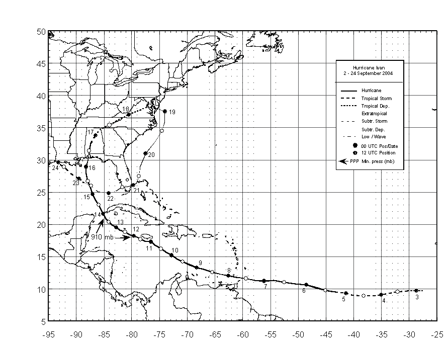
this whole scenario seems eerily similar to IVAN II....it also hugged the coast a good ways before coming ashore in SWLA....

Ivan came off the VA/Maryland coast line, traveled over the Atlantic across Florida and then into the Gulf way further south.

Image
0 likes   

Dean4Storms
S2K Supporter
S2K Supporter
Posts: 6358
Age: 62
Joined: Sun Aug 31, 2003 1:01 pm
Location: Miramar Bch. FL

#1864 Postby Dean4Storms » Sun Aug 15, 2010 5:31 pm

Did a search through WUnderground weather stations ENE of Panama City, they show pressures around 29.81" where I'm at 29.84" so it looks like the lowest pressure is near that rotation on radar.
0 likes   

User avatar
HeeBGBz
Category 1
Category 1
Posts: 341
Age: 70
Joined: Sun Sep 03, 2006 3:25 pm
Location: Biloxi, MS

Re: ATL: EX-Tropical Depression FIVE - Discussion

#1865 Postby HeeBGBz » Sun Aug 15, 2010 5:33 pm

Very intense electrical storm in Biloxi north of I10. Heavy downpour, loads of lightning. Dark as night.
0 likes   

User avatar
southerngale
Retired Staff
Retired Staff
Posts: 27418
Joined: Thu Oct 10, 2002 1:27 am
Location: Southeast Texas (Beaumont area)

Re: ATL: EX-Tropical Depression FIVE - Discussion

#1866 Postby southerngale » Sun Aug 15, 2010 5:35 pm

ROCK wrote:12Z EURO would suggest even more west to mid-Texas coast...if that was the case then it would have plenty of water to get going....I wouldnt discount it WXMN57.....

this whole scenario seems eerily similar to IVAN II....it also hugged the coast a good ways before coming ashore in SWLA....


hmmm... that's not what I saw. Can you post the link in the models thread?
0 likes   
Please support Storm2k by making a donation today. It is greatly appreciated! Click here: Image

Image my Cowboys Image my RocketsImage my Astros

User avatar
wxman57
Moderator-Pro Met
Moderator-Pro Met
Posts: 22978
Age: 67
Joined: Sat Jun 21, 2003 8:06 pm
Location: Houston, TX (southwest)

Re: ATL: EX-Tropical Depression FIVE - Discussion

#1867 Postby wxman57 » Sun Aug 15, 2010 5:40 pm

ROCK wrote:12Z EURO would suggest even more west to mid-Texas coast...if that was the case then it would have plenty of water to get going....I wouldnt discount it WXMN57.....

this whole scenario seems eerily similar to IVAN II....it also hugged the coast a good ways before coming ashore in SWLA....


The Euro has been too far west with almost every storm this year (if not every one). For now, I discount it.
0 likes   

cwachal

#1868 Postby cwachal » Sun Aug 15, 2010 5:43 pm

you would not have thought that TD5 would be a "long track" system
0 likes   

tolakram
Admin
Admin
Posts: 20009
Age: 62
Joined: Sun Aug 27, 2006 8:23 pm
Location: Florence, KY (name is Mark)

Re: ATL: EX-Tropical Depression FIVE - Discussion

#1869 Postby tolakram » Sun Aug 15, 2010 5:49 pm

15 frame Loop: http://wwwghcc.msfc.nasa.gov/cgi-bin/ge ... mframes=15

You can modify that link to move the location around and increase the number of frames (30 max).
0 likes   
M a r k
- - - - -
Join us in chat: Storm2K Chatroom Invite. Android and IOS apps also available.

The posts in this forum are NOT official forecasts and should not be used as such. Posts are NOT endorsed by any professional institution or STORM2K.org. For official information and forecasts, please refer to NHC and NWS products.

caneman

Re: ATL: EX-Tropical Depression FIVE - Discussion

#1870 Postby caneman » Sun Aug 15, 2010 5:56 pm

wxman57 wrote:
ROCK wrote:12Z EURO would suggest even more west to mid-Texas coast...if that was the case then it would have plenty of water to get going....I wouldnt discount it WXMN57.....

this whole scenario seems eerily similar to IVAN II....it also hugged the coast a good ways before coming ashore in SWLA....


The Euro has been too far west with almost every storm this year (if not every one). For now, I discount it.


Ahhhh, Thanks wxmn57, I'm sure the Euro crowd here on Storm 2K won't like to hear it but the truth hurts :wink: and now get back to the blending of models :D . Just as NHC does.
0 likes   

caneman

Re: ATL: EX-Tropical Depression FIVE - Discussion

#1871 Postby caneman » Sun Aug 15, 2010 5:59 pm

Steve has mentioned this before but the Euro has a West bias just as some other models have a East bias. That West bias has clearly shown its head this year.
0 likes   

Dean4Storms
S2K Supporter
S2K Supporter
Posts: 6358
Age: 62
Joined: Sun Aug 31, 2003 1:01 pm
Location: Miramar Bch. FL

#1872 Postby Dean4Storms » Sun Aug 15, 2010 5:59 pm

Reports of 40-50mph wind gusts around Mobile, AL in some of those heavier TStorms moving southward.
0 likes   

User avatar
srainhoutx
S2K Supporter
S2K Supporter
Posts: 6919
Age: 67
Joined: Sun Jan 14, 2007 11:34 am
Location: Haywood County, NC
Contact:

Re: ATL: EX-Tropical Depression FIVE - Discussion

#1873 Postby srainhoutx » Sun Aug 15, 2010 6:03 pm

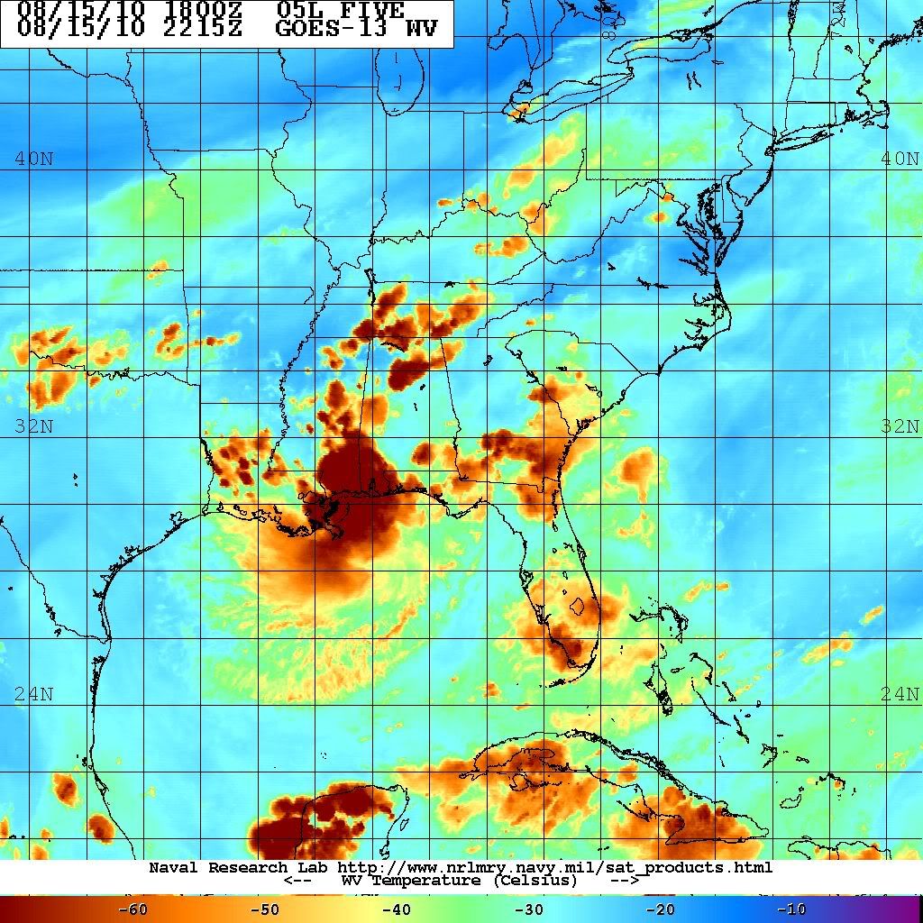
Water Vapor view...

Image
0 likes   
Carla/Alicia/Jerry(In The Eye)/Michelle/Charley/Ivan/Dennis/Katrina/Rita/Wilma/Ike/Harvey

Member: National Weather Association
Wx Infinity Forums
http://wxinfinity.com/index.php

Facebook.com/WeatherInfinity
Twitter @WeatherInfinity

Dean4Storms
S2K Supporter
S2K Supporter
Posts: 6358
Age: 62
Joined: Sun Aug 31, 2003 1:01 pm
Location: Miramar Bch. FL

Re: ATL: EX-Tropical Depression FIVE - Discussion

#1874 Postby Dean4Storms » Sun Aug 15, 2010 6:03 pm

Image


The NWS in Mobile nailed what we are seeing on radar with the placement of the Low!!
0 likes   

User avatar
mvtrucking
S2K Supporter
S2K Supporter
Posts: 698
Age: 66
Joined: Sat Jul 09, 2005 10:01 am
Location: Monroe,La

Re: Models Develop Gulf System - EX-TD5 Thread

#1875 Postby mvtrucking » Sun Aug 15, 2010 6:04 pm

wxman57 wrote:I'm plotting surface pressures down to 1/4 millibar. GFS has it inland near Grand Isle, LA and passing north of Lafayette and well north of Lake Charles. At 84 hrs, it's at 31.4N/94.9W, just west of Lufkin. I guess we could call it east-central TX. Maybe close enough to us to give us some rain. Of course, this assumes a perfect GFS forecast, and the GFS has never been wrong with a tropical system...


Maybe we could end up with a shot of moisture here in north central Louisiana? We could sure use it also.
0 likes   

User avatar
vbhoutex
Storm2k Executive
Storm2k Executive
Posts: 29112
Age: 73
Joined: Wed Oct 09, 2002 11:31 pm
Location: Cypress, TX
Contact:

Re: ATL: EX-Tropical Depression FIVE - Discussion

#1876 Postby vbhoutex » Sun Aug 15, 2010 6:05 pm

Based on two different radars it appears to me that there is an elongated llc from Chattahooche to just NW of Panama City, It looks like it is a slow S to SSW drift. This is still going to take a good while to get back over the water and tighten up imo. It is also obvious that there is still a good feed of moisture setting up for this system. My guess is the N GOM is in for one heck of a dousing. The biggest question in my mind, and probably in most peoples minds is how far over the water will this get?
edit- Just saw the NWS graphic. That is spot on for location for sure.
0 likes   
Skywarn, C.E.R.T.
Please click below to donate to STORM2K to help with the expenses of keeping the site going:
Image

caneman

Re: ATL: EX-Tropical Depression FIVE - Discussion

#1877 Postby caneman » Sun Aug 15, 2010 6:05 pm

It doesn't appear that it will be much more than a rain maker. Anyone get the feeling that the North Gulf coast is the bullseye this year? We've had some good soakers from a couple of these systems on the West coast of Florida. Not sure about this area but seems to be shaping up as North Gulf coast.
0 likes   

User avatar
KWT
Category 5
Category 5
Posts: 31415
Joined: Tue Aug 17, 2004 11:02 am
Location: UK!!!

Re: ATL: EX-Tropical Depression FIVE - Discussion

#1878 Postby KWT » Sun Aug 15, 2010 6:13 pm

Dean4Storms wrote:The NWS in Mobile nailed what we are seeing on radar with the placement of the Low!!


Yeah its pretty obvious really where the low is located, the track IMO looks pretty good as well IMO, though I do think it could drop a little further south then that if the low is setting up down there.
0 likes   
Personal Forecast Disclaimer:
The posts in this forum are NOT official forecast and should not be used as such. They are just the opinion of the poster and may or may not be backed by sound meteorological data. They are NOT endorsed by any professional institution or storm2k.org. For official information, please refer to the NHC and NWS products

User avatar
ROCK
Category 5
Category 5
Posts: 9484
Age: 54
Joined: Tue Aug 17, 2004 7:30 am
Location: Kemah, Texas

Re: ATL: EX-Tropical Depression FIVE - Discussion

#1879 Postby ROCK » Sun Aug 15, 2010 6:15 pm

wxman57 wrote:
ROCK wrote:12Z EURO would suggest even more west to mid-Texas coast...if that was the case then it would have plenty of water to get going....I wouldnt discount it WXMN57.....

this whole scenario seems eerily similar to IVAN II....it also hugged the coast a good ways before coming ashore in SWLA....


The Euro has been too far west with almost every storm this year (if not every one). For now, I discount it.


Yeah thats too bad you feel that way. It should have equal if not more weight than the east bias GFS...but we all have our favorites.... :D
0 likes   

Ikester
Professional-Met
Professional-Met
Posts: 361
Age: 39
Joined: Mon Jun 21, 2010 5:00 pm
Location: Jacksonville, FL

Re: ATL: EX-Tropical Depression FIVE - Discussion

#1880 Postby Ikester » Sun Aug 15, 2010 6:15 pm

KWT wrote:
Dean4Storms wrote:The NWS in Mobile nailed what we are seeing on radar with the placement of the Low!!


Yeah its pretty obvious really where the low is located, the track IMO looks pretty good as well IMO, though I do think it could drop a little further south then that if the low is setting up down there.


Every mile counts thanks to the layout of the gulf coast. With each mile further south, it has that much better of a chance to round Louisiana instead of crashing into it. Though really all bets are on the trough.
0 likes   


Return to “2010”

Who is online

Users browsing this forum: No registered users and 5 guests