ATL: Remnants of PAULA - Discussion
Moderator: S2k Moderators
-
Florida1118
Re: ATL : INVEST 98L - Discussion
Still looks like a TD. TD 5 looked worse and was elongated an loose.
0 likes
-
srainhoutx

- S2K Supporter

- Posts: 6919
- Age: 68
- Joined: Sun Jan 14, 2007 11:34 am
- Location: Haywood County, NC
- Contact:
Re: ATL : INVEST 98L - Discussion
0 likes
Carla/Alicia/Jerry(In The Eye)/Michelle/Charley/Ivan/Dennis/Katrina/Rita/Wilma/Ike/Harvey
Member: National Weather Association
Wx Infinity Forums
http://wxinfinity.com/index.php
Facebook.com/WeatherInfinity
Twitter @WeatherInfinity
Member: National Weather Association
Wx Infinity Forums
http://wxinfinity.com/index.php
Facebook.com/WeatherInfinity
Twitter @WeatherInfinity
-
SouthDadeFish

- Professional-Met

- Posts: 2836
- Joined: Thu Sep 23, 2010 2:54 pm
- Location: Miami, FL
- Contact:
-
cycloneye

- Admin

- Posts: 149585
- Age: 69
- Joined: Thu Oct 10, 2002 10:54 am
- Location: San Juan, Puerto Rico
Re: ATL : INVEST 98L - Discussion
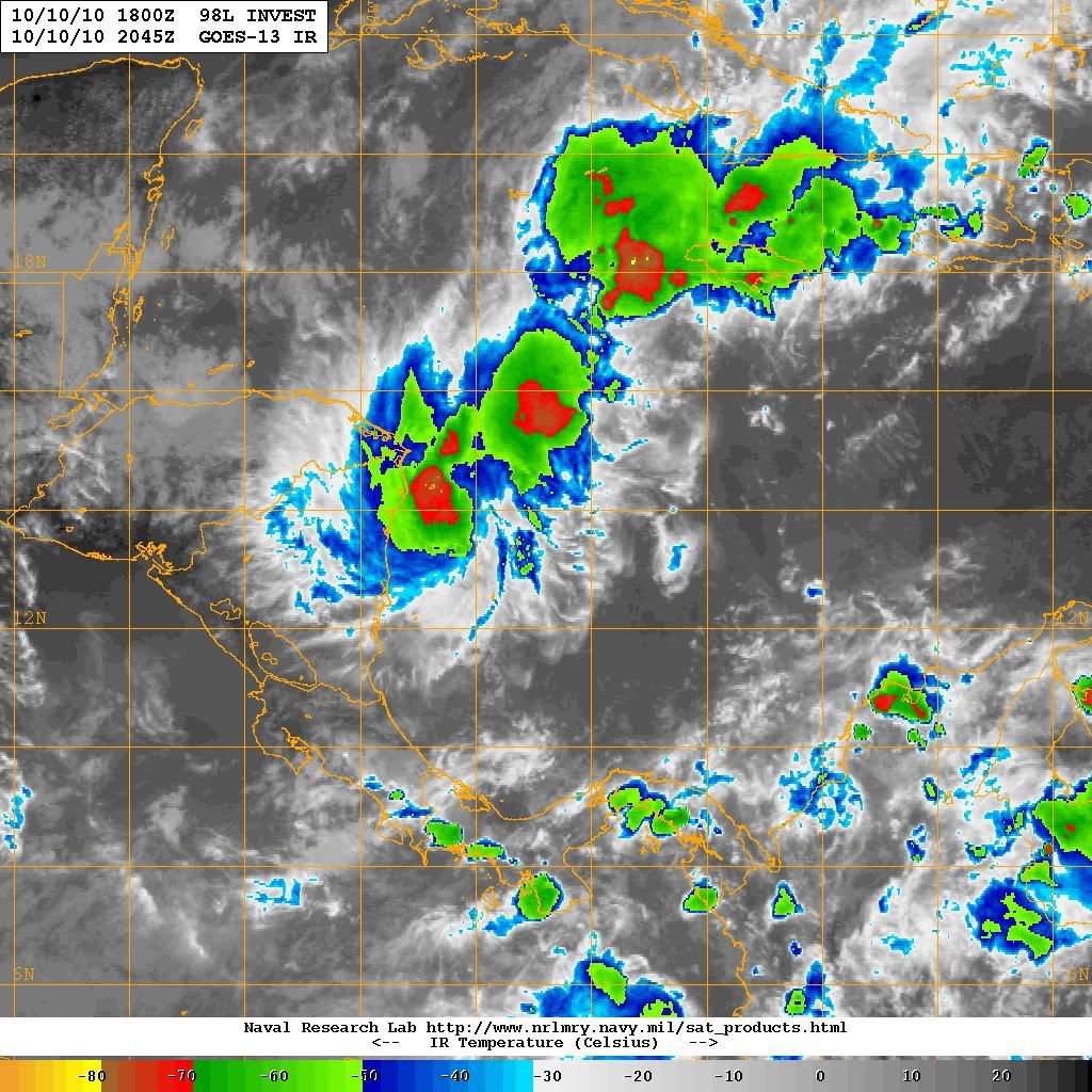
Steve, that image shows that is possible a reformation more north as it continues elongated.
0 likes
Visit the Caribbean-Central America Weather Thread where you can find at first post web cams,radars
and observations from Caribbean basin members Click Here
and observations from Caribbean basin members Click Here
-
Florida1118
Re: ATL : INVEST 98L - Discussion
NWS Tampa-
...BUT MODELS ARE TRYING TO DEVELOP AN AREA
OF LOW PRESSURE IN THE WESTERN CARIBBEAN
WITH SOME MOISTURE FROM THIS SYSTEM BEING PULLED NORTHEAST INTO
SOUTH FLORIDA AHEAD OF THE TROUGH/WEAKENING SURFACE COOL FRONT
DURING WEDNESDAY AND THURSDAY. THIS MOISTURE GETS PUSHED SOUTH AND
EAST OF THE AREA LATE IN THE WEEK AS ANOTHER HIGH PRESSURE BUILDS IN
FROM THE CENTRAL PLAINS.
NWS Miami-
A TROUGH OF LOW PRESSURE EXTENDING NORTHEAST FROM
THE TROPICAL DISTURBANCE IN THE
SOUTHERN BAHAMA ISLANDS WILL MOVE SLOWLY NORTH TOWARDS SOUTH
FLORIDA.
NWS Key West-
WE NOTE A 24-HOUR POLEWARD TREND IN
CONVECTIVE CLOUDINESS OVER THE WESTERN CARIBBEAN SEA. THE DEEP
TROPICAL MOISTURE IS ACTUALLY NOT FAR FROM THE KEYS AT PRESENT...EVEN
THOUGH SUCH AN AIR MASS HAS BEEN DECIDEDLY ABSENT IN THE KEYS DURING
THE FIRST TEN DAYS OF OCTOBER. THE LAST 3-4 CYCLES OF OUTPUT FROM
SEVERAL MACHINE MODELS SUGGEST THE INCREASING LIKELIHOOD OF MOISTURE
AND LIFT RETURNING TO THE FLORIDA KEYS AND ADJACENT COASTAL WATERS
FROM THE SOUTH AS THE SYSTEM CURRENTLY OVER THE GREAT PLAINS DIGS
EQUATORWARD AND DRAWS HIGH THETA-E AIR NORTHWARD OVER EXTREME
SOUTHERN FLORIDA.
0 likes
-
alienstorm

- Category 1

- Posts: 496
- Joined: Tue Jul 31, 2007 1:29 pm
- Location: Miami Fla western suburb
Will be going onshore latter this evening from the looks of thing moving WNW
0 likes
Personal Forecast Disclaimer:The posts in this forum are NOT official forecast and should not be used as such. They are just the opinion of the poster and may or may not be backed by sound meteorological data. They are NOT endorsed by any professional institution or storm2k.org. For official information, please refer to the NHC and NWS products.

-
DanKellFla

- Category 5

- Posts: 1291
- Joined: Fri Mar 17, 2006 12:02 pm
- Location: Lake Worth, Florida
-
SouthDadeFish
- Professional-Met
- Posts: 2836
- Joined: Thu Sep 23, 2010 2:54 pm
- Location: Miami, FL
- Contact:
Re:
DanKellFla wrote:What happened to the NCH 5:00 PM update?
That's only if we have a classified depression or greater. They issue the outlooks at 2 am, 8 am, 2 pm, and 8pm for waves/invests.
0 likes
Re: ATL : INVEST 98L - Discussion
Quicker organization but headed 300* and should go into Nicaragua/Honduras.
The posts in this forum are NOT official forecast and should not be used as such. They are just the opinion of the poster and may or may not be backed by sound meteorological data. They are NOT endorsed by any professional institution or storm2k.org. For official information, please refer to the NHC and NWS products.
0 likes

Re: ATL : INVEST 98L - Discussion
Have to beleive that a newly formed center must be near reflecting to the surface, as land interaction with Honduras seems nearly imminent. If so, I could see a scenario where the northern extension of this quasi N/S trough attempts to reform near or under the other mid level vorticity attempting to form west of Jaimaca. At this latitude and at the current time, it would be a test of time, given the existing shear in place.
0 likes
Andy D
(For official information, please refer to the NHC and NWS products.)
(For official information, please refer to the NHC and NWS products.)

-
latitude_20

- Tropical Storm

- Posts: 196
- Joined: Wed Jun 30, 2010 6:46 am
- Location: Tulum, Mexico
- Contact:
Re: ATL : INVEST 98L - Discussion
Latest GFS seems to be climbing on board, but I seriously wonder how it can survive with the NW caribbean awash in dry air.
0 likes

Re: ATL : INVEST 98L - Discussion
Unless a forecast says "extreme south Florida," which is taken to be the Keys, and just says S Fl, how do we know how far up the coast the forecaster means? Sometimes, they don't even say SE or SW. 
0 likes
-
cycloneye
- Admin
- Posts: 149585
- Age: 69
- Joined: Thu Oct 10, 2002 10:54 am
- Location: San Juan, Puerto Rico
Re: ATL : INVEST 98L - Discussion
Down to 50%
TROPICAL WEATHER OUTLOOK
NWS TPC/NATIONAL HURRICANE CENTER MIAMI FL
800 PM EDT SUN OCT 10 2010
FOR THE NORTH ATLANTIC...CARIBBEAN SEA AND THE GULF OF MEXICO...
SHOWERS AND THUNDERSTORMS ASSOCIATED WITH AN ELONGATED AREA OF LOW
PRESSURE LOCATED ABOUT 160 MILES EAST OF THE COAST OF NICARAGUA
REMAIN DISORGANIZED. CONDITIONS APPEAR SOMEWHAT CONDUCIVE FOR
DEVELOPMENT DURING THE NEXT COUPLE OF DAYS AS THIS SYSTEMS MOVES
WEST-NORTHWESTWARD TO NORTHWESTWARD AT 5 TO 10 MPH. THERE IS A
MEDIUM CHANCE...50 PERCENT...OF THIS SYSTEM BECOMING A TROPICAL
CYCLONE DURING THE NEXT 48 HOURS. REGARDLESS OF DEVELOPMENT...
HEAVY RAINFALL IS POSSIBLE OVER PORTIONS OF NICARAGUA AND HONDURAS
DURING THE NEXT COUPLE OF DAYS.
ELSEWHERE...TROPICAL CYCLONE FORMATION IS NOT EXPECTED DURING THE
NEXT 48 HOURS.
$$
FORECASTER BROWN/CANGIALOSI
0 likes
Visit the Caribbean-Central America Weather Thread where you can find at first post web cams,radars
and observations from Caribbean basin members Click Here
and observations from Caribbean basin members Click Here
-
wxman57

- Moderator-Pro Met

- Posts: 23175
- Age: 68
- Joined: Sat Jun 21, 2003 8:06 pm
- Location: Houston, TX (southwest)
Re: ATL : INVEST 98L - Discussion - 8 PM TWO= Down to 50%
Surface obs suggest the circulation center east of Nicaragua has lifted above the surface. Good spin aloft, but the obs don't support an LLC near that visible rotation. It could be there's an LLC well east of that spin near the coast of Nicaragua, but no convection there. The disturbance was a lot better organized 24 hrs ago. Don't see any sign of an LLC farther north (west of Jamaica).
0 likes
Re: ATL : INVEST 98L - Discussion
I knew I heard the fat lady singing. She gets louder by the moment.
0 likes

Re: ATL : INVEST 98L - Discussion - 8 PM TWO= Down to 50%
I think the southern half going inland might be the best thing that can happen for its chances to develop. With the southern half weakening over land it will allow the northern half the ability to take over and tighten up the lower vorticity which has been very broad. I have been more cautious this year than normal about jumping on development. It is quite interesting to see how this year is playing out in the NW Caribbean. Despite very favorable SST's, lower than normal pressures, and a full fledged La Nina we have seen much difficulty in systems trying to organize with many competing low pressure areas and lots of broad circulations. It goes to show how many things need to be right to get development.
0 likes
-
DanKellFla
- Category 5
- Posts: 1291
- Joined: Fri Mar 17, 2006 12:02 pm
- Location: Lake Worth, Florida
Re: Re:
SouthDadeFish wrote:DanKellFla wrote:What happened to the NCH 5:00 PM update?
That's only if we have a classified depression or greater. They issue the outlooks at 2 am, 8 am, 2 pm, and 8pm for waves/invests.
Yeah.... Yeah... I knew that. I guess I am already jonesin' for some excitment.
0 likes
-
SFLcane

- S2K Supporter
- Posts: 10281
- Age: 48
- Joined: Sat Jun 05, 2010 1:44 pm
- Location: Lake Worth Florida
Re: ATL : INVEST 98L - Discussion - 8 PM TWO= Down to 50%
wxman57 wrote:Surface obs suggest the circulation center east of Nicaragua has lifted above the surface. Good spin aloft, but the obs don't support an LLC near that visible rotation. It could be there's an LLC well east of that spin near the coast of Nicaragua, but no convection there. The disturbance was a lot better organized 24 hrs ago. Don't see any sign of an LLC farther north (west of Jamaica).
The fact that both the GFDL/HWRF aren't doing much of anything with this is something to think about. Still feel the chance of this hitting FL as a strong cyclone are slim to none due to very strong westerly flow in the GOM not going anywere anytime soon.
Last edited by SFLcane on Sun Oct 10, 2010 7:43 pm, edited 1 time in total.
0 likes
Who is online
Users browsing this forum: No registered users and 44 guests