
92L up against some mightly shear. I wouldn't expect anything happening over the next 2-3 days. Boy, look how active the ITCZ is across the entire Atlantic.
http://raleighwx.easternuswx.com/models/satellite/ETropical4kmIR.html
ATL : INVEST 92L - DISCUSSION
Moderator: S2k Moderators
-
cycloneye

- Admin

- Posts: 149508
- Age: 69
- Joined: Thu Oct 10, 2002 10:54 am
- Location: San Juan, Puerto Rico
Re: ATL : INVEST 92L - DISCUSSION
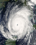
Cold cloud tops of -80C represented by those yellows.

0 likes
Visit the Caribbean-Central America Weather Thread where you can find at first post web cams,radars
and observations from Caribbean basin members Click Here
and observations from Caribbean basin members Click Here
-
Gustywind

- Category 5

- Posts: 12334
- Joined: Mon Sep 03, 2007 7:29 am
- Location: Baie-Mahault, GUADELOUPE
For those who want to see the radar of Guadeloupe, and have the weather prediction for the next 3 hours in Guadeloupe, here is a link 
http://www.meteo.gp/donnees/bulletin/3h/bul_3h_guad.php
http://www.meteo.gp/donnees/bulletin/3h/bul_3h_guad.php
0 likes


-
cycloneye
- Admin
- Posts: 149508
- Age: 69
- Joined: Thu Oct 10, 2002 10:54 am
- Location: San Juan, Puerto Rico
Re: ATL : INVEST 92L - DISCUSSION
00 UTC Best Track
Maybe a tad slower.
AL, 92, 2010061800, , BEST, 0, 161N, 593W, 25, 1011, WV
ftp://ftp.tpc.ncep.noaa.gov/atcf/tcweb/ ... 010.invest
Whole data from the start.
INVEST, AL, L, , , , , 92, 2010, DB, O, 2010061218, 9999999999, , , , , , METWATCH, , AL922010
AL, 92, 2010061118, , BEST, 0, 60N, 275W, 20, 1012, DB, 0, , 0, 0, 0, 0,
AL, 92, 2010061200, , BEST, 0, 61N, 284W, 20, 1012, DB, 0, , 0, 0, 0, 0,
AL, 92, 2010061206, , BEST, 0, 61N, 293W, 20, 1012, DB, 0, , 0, 0, 0, 0,
AL, 92, 2010061212, , BEST, 0, 62N, 301W, 20, 1012, DB, 0, , 0, 0, 0, 0,
AL, 92, 2010061218, , BEST, 0, 63N, 310W, 25, 1012, DB, 0, , 0, 0, 0, 0, 1014, 120, 30, 0, 0, L, 0, , 0, 0, INVEST, D,
AL, 92, 2010061300, , BEST, 0, 64N, 321W, 20, 1012, DB, 0, , 0, 0, 0, 0, 1014, 150, 45, 0, 0, L, 0, , 0, 0, INVEST, D,
AL, 92, 2010061306, , BEST, 0, 67N, 335W, 25, 1012, DB, 0, , 0, 0, 0, 0,
AL, 92, 2010061312, , BEST, 0, 71N, 349W, 25, 1011, DB, 0, , 0, 0, 0, 0, 1014, 200, 45, 0, 0, L, 0, , 0, 0, INVEST, D,
AL, 92, 2010061318, , BEST, 0, 77N, 363W, 25, 1010, DB, 0, , 0, 0, 0, 0, 1012, 200, 50, 0, 0, L, 0, , 0, 0, INVEST, D,
AL, 92, 2010061400, , BEST, 0, 84N, 376W, 25, 1010, DB, 0, , 0, 0, 0, 0, 1013, 240, 60, 35, 0, L, 0, , 0, 0, INVEST, D,
AL, 92, 2010061406, , BEST, 0, 90N, 388W, 25, 1010, DB, 0, , 0, 0, 0, 0,
AL, 92, 2010061412, , BEST, 0, 97N, 399W, 25, 1011, DB, 0, , 0, 0, 0, 0, 1014, 225, 60, 0, 0, L, 0, , 0, 0, INVEST, D,
AL, 92, 2010061418, , BEST, 0, 105N, 410W, 25, 1011, DB, 0, , 0, 0, 0, 0, 1014, 225, 60, 0, 0, L, 0, , 0, 0, INVEST, D,
AL, 92, 2010061500, , BEST, 0, 113N, 421W, 25, 1011, DB, 0, , 0, 0, 0, 0, 1014, 200, 60, 35, 0, L, 0, , 0, 0, INVEST, D,
AL, 92, 2010061506, , BEST, 0, 122N, 432W, 25, 1011, DB, 0, , 0, 0, 0, 0,
AL, 92, 2010061512, , BEST, 0, 130N, 444W, 25, 1011, DB, 0, , 0, 0, 0, 0, 1013, 150, 60, 0, 0, L, 0, , 0, 0, INVEST, M,
AL, 92, 2010061518, , BEST, 0, 136N, 457W, 25, 1011, DB, 0, , 0, 0, 0, 0,
AL, 92, 2010061600, , BEST, 0, 141N, 475W, 30, 1010, DB, 0, , 0, 0, 0, 0, 1013, 150, 60, 0, 0, L, 0, , 0, 0, INVEST, M,
AL, 92, 2010061606, , BEST, 0, 142N, 490W, 30, 1010, DB, 0, , 0, 0, 0, 0,
AL, 92, 2010061612, , BEST, 0, 144N, 508W, 30, 1011, DB, 0, , 0, 0, 0, 0, 1013, 125, 60, 0, 0, L, 0, , 0, 0, INVEST, M,
AL, 92, 2010061618, , BEST, 0, 148N, 521W, 25, 1011, DB, 0, , 0, 0, 0, 0,
AL, 92, 2010061700, , BEST, 0, 151N, 537W, 25, 1012, DB, 0, , 0, 0, 0, 0,
AL, 92, 2010061706, , BEST, 0, 155N, 554W, 25, 1013, WV, 0, , 0, 0, 0, 0,
AL, 92, 2010061712, , BEST, 0, 158N, 572W, 25, 1013, WV, 0, , 0, 0, 0, 0,
AL, 92, 2010061718, , BEST, 0, 160N, 583W, 25, 1012, WV, 0, , 0, 0, 0, 0, 1013, 125, 60, 0, 0, L, 0, , 0, 0, INVEST, M,
AL, 92, 2010061800, , BEST, 0, 161N, 593W, 25, 1011, WV,
0 likes
Visit the Caribbean-Central America Weather Thread where you can find at first post web cams,radars
and observations from Caribbean basin members Click Here
and observations from Caribbean basin members Click Here
-
Weatherfreak000
Re: ATL : INVEST 92L - DISCUSSION
92L is in that wedged middle portion of the two huge shear zones to the left and right. It appears to me we are definitely seeing shear induced convection, but the worst days of 92L's life are most certainly ahead of it. I am having a difficult time believing a path over the islands is reasonable to the storm's survival and whatever becomes of this thing going into either the florida straits or the Yucatan area is got to be primed towards rapid development in an area that can easily support a major hurricane.
0 likes
-
Gustywind
- Category 5
- Posts: 12334
- Joined: Mon Sep 03, 2007 7:29 am
- Location: Baie-Mahault, GUADELOUPE
Re: ATL : INVEST 92L - DISCUSSION
cycloneye wrote:00 UTC Best Track
Maybe a tad slower.
AL, 92, 2010061800, , BEST, 0, 161N, 593W, 25, 1011, WV
ftp://ftp.tpc.ncep.noaa.gov/atcf/tcweb/ ... 010.invest
Whole data from the start.
INVEST, AL, L, , , , , 92, 2010, DB, O, 2010061218, 9999999999, , , , , , METWATCH, , AL922010
AL, 92, 2010061118, , BEST, 0, 60N, 275W, 20, 1012, DB, 0, , 0, 0, 0, 0,
AL, 92, 2010061200, , BEST, 0, 61N, 284W, 20, 1012, DB, 0, , 0, 0, 0, 0,
AL, 92, 2010061206, , BEST, 0, 61N, 293W, 20, 1012, DB, 0, , 0, 0, 0, 0,
AL, 92, 2010061212, , BEST, 0, 62N, 301W, 20, 1012, DB, 0, , 0, 0, 0, 0,
AL, 92, 2010061218, , BEST, 0, 63N, 310W, 25, 1012, DB, 0, , 0, 0, 0, 0, 1014, 120, 30, 0, 0, L, 0, , 0, 0, INVEST, D,
AL, 92, 2010061300, , BEST, 0, 64N, 321W, 20, 1012, DB, 0, , 0, 0, 0, 0, 1014, 150, 45, 0, 0, L, 0, , 0, 0, INVEST, D,
AL, 92, 2010061306, , BEST, 0, 67N, 335W, 25, 1012, DB, 0, , 0, 0, 0, 0,
AL, 92, 2010061312, , BEST, 0, 71N, 349W, 25, 1011, DB, 0, , 0, 0, 0, 0, 1014, 200, 45, 0, 0, L, 0, , 0, 0, INVEST, D,
AL, 92, 2010061318, , BEST, 0, 77N, 363W, 25, 1010, DB, 0, , 0, 0, 0, 0, 1012, 200, 50, 0, 0, L, 0, , 0, 0, INVEST, D,
AL, 92, 2010061400, , BEST, 0, 84N, 376W, 25, 1010, DB, 0, , 0, 0, 0, 0, 1013, 240, 60, 35, 0, L, 0, , 0, 0, INVEST, D,
AL, 92, 2010061406, , BEST, 0, 90N, 388W, 25, 1010, DB, 0, , 0, 0, 0, 0,
AL, 92, 2010061412, , BEST, 0, 97N, 399W, 25, 1011, DB, 0, , 0, 0, 0, 0, 1014, 225, 60, 0, 0, L, 0, , 0, 0, INVEST, D,
AL, 92, 2010061418, , BEST, 0, 105N, 410W, 25, 1011, DB, 0, , 0, 0, 0, 0, 1014, 225, 60, 0, 0, L, 0, , 0, 0, INVEST, D,
AL, 92, 2010061500, , BEST, 0, 113N, 421W, 25, 1011, DB, 0, , 0, 0, 0, 0, 1014, 200, 60, 35, 0, L, 0, , 0, 0, INVEST, D,
AL, 92, 2010061506, , BEST, 0, 122N, 432W, 25, 1011, DB, 0, , 0, 0, 0, 0,
AL, 92, 2010061512, , BEST, 0, 130N, 444W, 25, 1011, DB, 0, , 0, 0, 0, 0, 1013, 150, 60, 0, 0, L, 0, , 0, 0, INVEST, M,
AL, 92, 2010061518, , BEST, 0, 136N, 457W, 25, 1011, DB, 0, , 0, 0, 0, 0,
AL, 92, 2010061600, , BEST, 0, 141N, 475W, 30, 1010, DB, 0, , 0, 0, 0, 0, 1013, 150, 60, 0, 0, L, 0, , 0, 0, INVEST, M,
AL, 92, 2010061606, , BEST, 0, 142N, 490W, 30, 1010, DB, 0, , 0, 0, 0, 0,
AL, 92, 2010061612, , BEST, 0, 144N, 508W, 30, 1011, DB, 0, , 0, 0, 0, 0, 1013, 125, 60, 0, 0, L, 0, , 0, 0, INVEST, M,
AL, 92, 2010061618, , BEST, 0, 148N, 521W, 25, 1011, DB, 0, , 0, 0, 0, 0,
AL, 92, 2010061700, , BEST, 0, 151N, 537W, 25, 1012, DB, 0, , 0, 0, 0, 0,
AL, 92, 2010061706, , BEST, 0, 155N, 554W, 25, 1013, WV, 0, , 0, 0, 0, 0,
AL, 92, 2010061712, , BEST, 0, 158N, 572W, 25, 1013, WV, 0, , 0, 0, 0, 0,
AL, 92, 2010061718, , BEST, 0, 160N, 583W, 25, 1012, WV, 0, , 0, 0, 0, 0, 1013, 125, 60, 0, 0, L, 0, , 0, 0, INVEST, M,
AL, 92, 2010061800, , BEST, 0, 161N, 593W, 25, 1011, WV,
Pressure down to 1011 ...
0 likes


Re: ATL : INVEST 92L - DISCUSSION
Wow! I can't believe this storm is making a come back. It's definitely something to keep an eye on. 
0 likes
____________________________
I survived Allison, Rita, Humberto, Edouard, and Ike.
I survived Allison, Rita, Humberto, Edouard, and Ike.
-
Gustywind
- Category 5
- Posts: 12334
- Joined: Mon Sep 03, 2007 7:29 am
- Location: Baie-Mahault, GUADELOUPE
Re: ATL : INVEST 92L - DISCUSSION
OURAGAN wrote:It will cross my island of Guadeloupe.
What's the weather like in your area Ouragan?
0 likes
-
Gustywind
- Category 5
- Posts: 12334
- Joined: Mon Sep 03, 2007 7:29 am
- Location: Baie-Mahault, GUADELOUPE
000
AXNT20 KNHC 180001
TWDAT
TROPICAL WEATHER DISCUSSION
NWS TPC/NATIONAL HURRICANE CENTER MIAMI FL
805 PM EDT THU JUN 17 2010
TROPICAL WEATHER DISCUSSION FOR NORTH AMERICA...CENTRAL
AMERICA...GULF OF MEXICO...CARIBBEAN SEA...NORTHERN SECTIONS OF
SOUTH AMERICA...AND ATLANTIC OCEAN TO THE AFRICAN COAST FROM THE
EQUATOR TO 32N. THE FOLLOWING INFORMATION IS BASED ON SATELLITE
IMAGERY...METEOROLOGICAL ANALYSIS...WEATHER OBSERVATIONS...AND
RADAR.
BASED ON 1800 UTC SURFACE ANALYSIS AND SATELLITE IMAGERY THROUGH
2315 UTC...
...TROPICAL WAVES...
A TROUGH OF LOW PRESSURE IS APPROACHING THE LESSER ANTILLES
ALONG 22N57W TO 13N59W. LOW-LEVEL CYCLONIC FLOW REMAINS
CONCENTRATED NEAR A 1012 MB LOW ALONG THE AXIS NEAR 16N. SEVERAL
DAYS AGO THIS SYSTEM HAD A HIGHER CHANCE OF DEVELOPING INTO A
TROPICAL CYCLONE...BUT DUE TO STRONG UPPER LEVEL WINDS THERE IS
CURRENTLY A LOW PROBABILITY OF DEVELOPMENT. HOWEVER...THIS
SYSTEM CONTINUES TO BE EMBEDDED IN A LARGE AREA OF ENHANCED DEEP
LAYER MOISTURE BETWEEN 50W-62W SUPPORTING WIDESPREAD SHOWER
ACTIVITY. NUMEROUS STRONG CONVECTION IS NEAR THE LOW CENTER FROM
15N-18N BETWEEN 56W-59W WITH SCATTERED MODERATE/ISOLATED STRONG
CONVECTION FROM 14N-22N BETWEEN 53W-56W. AS THIS SYSTEM MOVES
WWD...LOCALLY HEAVY RAINFALL IS POSSIBLE OVER THE LEEWARD
ISLANDS...THE VIRGIN ISLANDS...AND PUERTO RICO.
0 likes
Re: ATL : INVEST 92L - DISCUSSION
The weather is calm at Baie-Mahault for the moment, but tomorrow we will get very strong showers and thunderstorms.
0 likes
-
Ivanhater

- Storm2k Moderator

- Posts: 11221
- Age: 39
- Joined: Fri Jul 01, 2005 8:25 am
- Location: Pensacola
Re: ATL : INVEST 92L - DISCUSSION
Regardless if this get upgraded or not will not matter much for the Islands, the effects will be the same...nasty
0 likes
Michael
-
Gustywind
- Category 5
- Posts: 12334
- Joined: Mon Sep 03, 2007 7:29 am
- Location: Baie-Mahault, GUADELOUPE
Re: ATL : INVEST 92L - DISCUSSION
OURAGAN wrote:The weather is calm at Baie-Mahault for the moment, but tomorrow we will get very strong showers and thunderstorms.
ok thanks
0 likes
-
Gustywind
- Category 5
- Posts: 12334
- Joined: Mon Sep 03, 2007 7:29 am
- Location: Baie-Mahault, GUADELOUPE
Re: ATL : INVEST 92L - DISCUSSION
Ivanhater wrote:Regardless if this get upgraded or not will not matter much for the Islands, the effects will be the same...nasty
0 likes
-
cycloneye
- Admin
- Posts: 149508
- Age: 69
- Joined: Thu Oct 10, 2002 10:54 am
- Location: San Juan, Puerto Rico
Re: ATL : INVEST 92L - DISCUSSION
For those members in the Caribbean that may post observations as 92L moves thru the islands,you can post them at the Caribbean thread at U.S. & Caribbean forum to not congest this 92L thread like a traffic jam.
Caribbean - Central America Weather Thread
Caribbean - Central America Weather Thread
0 likes
Visit the Caribbean-Central America Weather Thread where you can find at first post web cams,radars
and observations from Caribbean basin members Click Here
and observations from Caribbean basin members Click Here
-
Gustywind
- Category 5
- Posts: 12334
- Joined: Mon Sep 03, 2007 7:29 am
- Location: Baie-Mahault, GUADELOUPE
Re: ATL : INVEST 92L - DISCUSSION
cycloneye wrote:For those members in the Caribbean that may post observations as 92L moves thru the islands,you can post them at the Caribbean thread at U.S. & Caribbean forum to not congest this 92L thread like a traffic jam.
Caribbean - Central America Weather Thread
0 likes
-
wxman57

- Moderator-Pro Met

- Posts: 23175
- Age: 68
- Joined: Sat Jun 21, 2003 8:06 pm
- Location: Houston, TX (southwest)
Re: ATL : INVEST 92L - DISCUSSION
Martinique radar here:
http://www.meteo.fr/temps/domtom/antill ... SAIC2.html
http://www.meteo.fr/temps/domtom/antill ... SAIC2.html
0 likes
Who is online
Users browsing this forum: No registered users and 35 guests