EPAC: DORA - Remnants
Moderator: S2k Moderators
-
plasticup
Re: EPAC: DORA - Hurricane
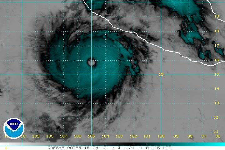
Dora's eye looks to be a little clearer and a little better defined. But the cloud-tops have warmed slightly. She should have another 24-36 hours of warm SST, so we'll see tomorrow whether she makes the push for category 5 strength.
0 likes
-
Yellow Evan

- Professional-Met

- Posts: 16232
- Age: 27
- Joined: Fri Jul 15, 2011 12:48 pm
- Location: Henderson, Nevada/Honolulu, HI
- Contact:
Re: EPAC: DORA - Hurricane
plasticup wrote:Dora's eye looks to be a little clearer and a little better defined. But the cloud-tops have warmed slightly. She should have another 24-36 hours of warm SST, so we'll see tomorrow whether she makes the push for category 5 strength.
I would love to see a Cat 5 as a Dora. Is she the strongest Dora yet?
0 likes
-
CrazyC83
- Professional-Met
- Posts: 34315
- Joined: Tue Mar 07, 2006 11:57 pm
- Location: Deep South, for the first time!
Re: EPAC: DORA - Hurricane
Yellow Evan wrote:plasticup wrote:Dora's eye looks to be a little clearer and a little better defined. But the cloud-tops have warmed slightly. She should have another 24-36 hours of warm SST, so we'll see tomorrow whether she makes the push for category 5 strength.
I would love to see a Cat 5 as a Dora. Is she the strongest Dora yet?
The 1964 Dora in the Atlantic had a pressure of 942mb.
0 likes
-
HURAKAN

- Professional-Met
- Posts: 46084
- Age: 39
- Joined: Thu May 20, 2004 4:34 pm
- Location: Key West, FL
- Contact:
Re: EPAC: DORA - Hurricane
Yellow Evan wrote:plasticup wrote:Dora's eye looks to be a little clearer and a little better defined. But the cloud-tops have warmed slightly. She should have another 24-36 hours of warm SST, so we'll see tomorrow whether she makes the push for category 5 strength.
I would love to see a Cat 5 as a Dora. Is she the strongest Dora yet?
Dora in 1999 got up to 140 mph ... my guess this one will surpass it
0 likes


Its certainly got the time to make it to category-5 and it does look like an impressive system thats for sure...
Could get a run at 5 for tomorrow morning when we get Dmax, suspect we'll be in the 130-140kts range by then.
Could get a run at 5 for tomorrow morning when we get Dmax, suspect we'll be in the 130-140kts range by then.
0 likes
Personal Forecast Disclaimer:
The posts in this forum are NOT official forecast and should not be used as such. They are just the opinion of the poster and may or may not be backed by sound meteorological data. They are NOT endorsed by any professional institution or storm2k.org. For official information, please refer to the NHC and NWS products
The posts in this forum are NOT official forecast and should not be used as such. They are just the opinion of the poster and may or may not be backed by sound meteorological data. They are NOT endorsed by any professional institution or storm2k.org. For official information, please refer to the NHC and NWS products

Re:
KWT wrote:Its certainly got the time to make it to category-5 and it does look like an impressive system thats for sure...
Could get a run at 5 for tomorrow morning when we get Dmax, suspect we'll be in the 130-140kts range by then.
Well, that could be her only window of opportunity.
0 likes
NOTICE: I cannot give an expert analysis. Most of my "observations" are made visually with the help of only vital information provided by public advisories.


-
South Texas Storms

- Professional-Met
- Posts: 4256
- Joined: Thu Jun 24, 2010 12:28 am
- Location: Houston, TX
Re: EPAC: DORA - Hurricane
Wow what a beautiful major hurricane Dora is right now! With no threat to land expected we can just say wow to her beautifulness.
0 likes
-
Battlebrick
- Tropical Storm

- Posts: 177
- Joined: Thu Sep 02, 2010 9:55 pm
Re: EPAC: DORA - Hurricane
it looks like it's shrinking in size.. reason for that?
0 likes
Lim_Fao on IRC.
The following post is NOT an official forecast and should not be used as such. It is just the opinion of the poster and may or may not be backed by sound meteorological data. It is NOT endorsed by any professional institution including storm2k.org. For Official Information please refer to the NHC and NWS products.
The following post is NOT an official forecast and should not be used as such. It is just the opinion of the poster and may or may not be backed by sound meteorological data. It is NOT endorsed by any professional institution including storm2k.org. For Official Information please refer to the NHC and NWS products.

Re: EPAC: DORA - Hurricane
Yeah I was thinking about it, seems to have gained some annular characteristics: big eye, little banding, very simmetrical, but I agree is not annular yet and maybe it won't be, anyway is such a beautiful hurricane. With that big eye I bet she's a good explorer 
0 likes
-
Battlebrick
- Tropical Storm
- Posts: 177
- Joined: Thu Sep 02, 2010 9:55 pm
Re: EPAC: DORA - Hurricane
Estimates on size of eye? 20 nm?
0 likes
Lim_Fao on IRC.
The following post is NOT an official forecast and should not be used as such. It is just the opinion of the poster and may or may not be backed by sound meteorological data. It is NOT endorsed by any professional institution including storm2k.org. For Official Information please refer to the NHC and NWS products.
The following post is NOT an official forecast and should not be used as such. It is just the opinion of the poster and may or may not be backed by sound meteorological data. It is NOT endorsed by any professional institution including storm2k.org. For Official Information please refer to the NHC and NWS products.
Re: EPAC: DORA - Hurricane
Battlebrick wrote:Estimates on size of eye? 20 nm?
Looks to be about 0.6 degrees of latitude across which would be about 36 nm (0.6 degree = 36 minutes = 36 nm)
0 likes
-
Battlebrick
- Tropical Storm
- Posts: 177
- Joined: Thu Sep 02, 2010 9:55 pm
Re: EPAC: DORA - Hurricane
RL3AO wrote:Battlebrick wrote:Estimates on size of eye? 20 nm?
Looks to be about 0.6 degrees of latitude across which would be about 36 nm (0.6 degree = 36 minutes = 36 nm)
Wow, I was way off! Katrina's eye peaked at something like that, right?
0 likes
Lim_Fao on IRC.
The following post is NOT an official forecast and should not be used as such. It is just the opinion of the poster and may or may not be backed by sound meteorological data. It is NOT endorsed by any professional institution including storm2k.org. For Official Information please refer to the NHC and NWS products.
The following post is NOT an official forecast and should not be used as such. It is just the opinion of the poster and may or may not be backed by sound meteorological data. It is NOT endorsed by any professional institution including storm2k.org. For Official Information please refer to the NHC and NWS products.
Re: EPAC: DORA - Hurricane
The new advisory says there has been no change in intensity. 
0 likes
NOTICE: I cannot give an expert analysis. Most of my "observations" are made visually with the help of only vital information provided by public advisories.
Who is online
Users browsing this forum: No registered users and 28 guests