WPAC: RAGASA - Typhoon

Detailed discussion and tracking of all WestPac basin storms with special input from staff of our partner site, WesternPacificWeather

Moderators: S2k Moderators, WesternPacificWeatherMods

Forum rules

The posts in this forum are NOT official forecast and should not be used as such. They are just the opinion of the poster and may or may not be backed by sound meteorological data. They are NOT endorsed by any professional institution or STORM2K.

Help Support Storm2K
Message
Author
User avatar
Hurricane2022
Category 5
Category 5
Posts: 1697
Joined: Tue Aug 23, 2022 11:38 pm
Location: Araçatuba, Brazil

Re: WPAC: RAGASA - Typhoon

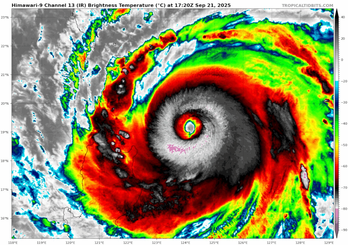
#141 Postby Hurricane2022 » Sun Sep 21, 2025 4:40 pm

Ulf wrote:It is extremely powerful typhoons like this one that always make me wish that JMA is not so conservative when it comes to pressure.

Especially when there are data on the ground.

JMA is stuck at 100 kt (10-min)/925 since yesterday. Oh, and they're also thinking that the C3 TY Neoguri is almost at the same intensity. :spam:
1 likes   
Sorry for the bad English sometimes...!
For reliable and detailed information for any meteorological phenomenon, please consult the National Hurricane Center, Joint Typhoon Warning Center , or your local Meteo Center.

--------

Una cvm Christo, pro Christo, et in Christo. Sit nomen Domini benedictvm.

User avatar
cycloneye
Admin
Admin
Posts: 146935
Age: 69
Joined: Thu Oct 10, 2002 10:54 am
Location: San Juan, Puerto Rico

Re: WPAC: RAGASA - Typhoon

#142 Postby cycloneye » Sun Sep 21, 2025 5:17 pm

Sunrise over Ragasa and wow.

Image
5 likes   
Visit the Caribbean-Central America Weather Thread where you can find at first post web cams,radars
and observations from Caribbean basin members Click Here

User avatar
Teban54
Category 5
Category 5
Posts: 3359
Joined: Sat May 19, 2018 1:19 pm

Re: WPAC: RAGASA - Typhoon

#143 Postby Teban54 » Sun Sep 21, 2025 5:35 pm

Image
1 likes   

User avatar
Hurricane2022
Category 5
Category 5
Posts: 1697
Joined: Tue Aug 23, 2022 11:38 pm
Location: Araçatuba, Brazil

Re: WPAC: RAGASA - Typhoon

#144 Postby Hurricane2022 » Sun Sep 21, 2025 5:35 pm

0 likes   
Sorry for the bad English sometimes...!
For reliable and detailed information for any meteorological phenomenon, please consult the National Hurricane Center, Joint Typhoon Warning Center , or your local Meteo Center.

--------

Una cvm Christo, pro Christo, et in Christo. Sit nomen Domini benedictvm.

User avatar
cycloneye
Admin
Admin
Posts: 146935
Age: 69
Joined: Thu Oct 10, 2002 10:54 am
Location: San Juan, Puerto Rico

Re: WPAC: RAGASA - Typhoon

#145 Postby cycloneye » Sun Sep 21, 2025 5:53 pm

Another stunning image.

Image
0 likes   
Visit the Caribbean-Central America Weather Thread where you can find at first post web cams,radars
and observations from Caribbean basin members Click Here

User avatar
Hurricane2022
Category 5
Category 5
Posts: 1697
Joined: Tue Aug 23, 2022 11:38 pm
Location: Araçatuba, Brazil

Re: WPAC: RAGASA - Typhoon

#146 Postby Hurricane2022 » Sun Sep 21, 2025 6:30 pm

0 likes   
Sorry for the bad English sometimes...!
For reliable and detailed information for any meteorological phenomenon, please consult the National Hurricane Center, Joint Typhoon Warning Center , or your local Meteo Center.

--------

Una cvm Christo, pro Christo, et in Christo. Sit nomen Domini benedictvm.

User avatar
Travorum
Category 1
Category 1
Posts: 462
Joined: Tue Sep 05, 2023 9:36 am
Location: Dunedin, FL

Re: WPAC: RAGASA - Typhoon

#147 Postby Travorum » Sun Sep 21, 2025 6:58 pm

18z HWRF and HAFS-A still showing a Hong Kong landfall, both weaker than 12z. Both are on the north end of both GFS and Euro ensembles.

ImageImage
0 likes   

User avatar
StormChaser75
Tropical Depression
Tropical Depression
Posts: 99
Age: 23
Joined: Sat Feb 06, 2016 4:23 pm
Location: Corpus Christi TX
Contact:

Re: WPAC: RAGASA - Typhoon

#148 Postby StormChaser75 » Sun Sep 21, 2025 7:15 pm

Absolutely stunning Super Typhoon RAGASA
Image
Image
2 likes   

User avatar
cycloneye
Admin
Admin
Posts: 146935
Age: 69
Joined: Thu Oct 10, 2002 10:54 am
Location: San Juan, Puerto Rico

Re: WPAC: RAGASA - Typhoon

#149 Postby cycloneye » Sun Sep 21, 2025 7:20 pm

Live stream from chaser James Reynolds in Batanes.

https://www.youtube.com/live/91q3-6QwWUE
0 likes   
Visit the Caribbean-Central America Weather Thread where you can find at first post web cams,radars
and observations from Caribbean basin members Click Here

User avatar
Iceresistance
Category 5
Category 5
Posts: 9304
Age: 22
Joined: Sat Oct 10, 2020 9:45 am
Location: Tecumseh, OK/Norman, OK

Re: WPAC: RAGASA - Typhoon

#150 Postby Iceresistance » Sun Sep 21, 2025 7:22 pm

0 likes   
Bill 2015 & Beta 2020

Winter 2020-2021 :cold:

All observations are in Tecumseh, OK unless otherwise noted.

Winter posts are focused mainly for Oklahoma & Texas.

Take any of my forecasts with a grain of salt, refer to the NWS, SPC, and NHC for official information

Never say Never with weather! Because ANYTHING is possible!

Fancy1002
Tropical Storm
Tropical Storm
Posts: 189
Joined: Sun Dec 25, 2022 3:47 pm

Re: WPAC: RAGASA - Typhoon

#151 Postby Fancy1002 » Sun Sep 21, 2025 7:23 pm

How did I not know this storm existed?
1 likes   

Hurricane2000
Tropical Low
Tropical Low
Posts: 38
Joined: Sat Dec 28, 2024 4:50 pm

Re: WPAC: RAGASA - Typhoon

#152 Postby Hurricane2000 » Sun Sep 21, 2025 7:33 pm

Image
0 likes   
Weather = Cool 8-)

User avatar
Hayabusa
Category 5
Category 5
Posts: 4584
Joined: Sun Sep 16, 2018 1:05 pm

Re: WPAC: RAGASA - Typhoon

#153 Postby Hayabusa » Sun Sep 21, 2025 7:52 pm

Although not a full eye pass, a 21:44:55 UTC SAR pass earlier found 145 kt winds on the western side of the storm
Last edited by Hayabusa on Sun Sep 21, 2025 7:55 pm, edited 1 time in total.
3 likes   
ヤンデレ女が寝取られるているのを見たい!!!
ECMWF ensemble NWPAC plots: https://ecmwfensnwpac.imgbb.com/
Multimodel NWPAC plots: https://multimodelnwpac.imgbb.com/
GFS Ensemble NWPAC plots (16 & 35 day forecast): https://gefsnwpac.imgbb.com/
Plots updated automatically

User avatar
Hayabusa
Category 5
Category 5
Posts: 4584
Joined: Sun Sep 16, 2018 1:05 pm

Re: WPAC: RAGASA - Typhoon

#154 Postby Hayabusa » Sun Sep 21, 2025 7:54 pm

Strongest TC of 2025 and forecast to go 900mb
T2518(Ragasa)
Issued at 2025/09/22 00:50 UTC
Analysis at 09/22 00 UTC
Grade TY
Scale -
Intensity Violent
Center position N19°25′ (19.4°)
E123°00′ (123.0°)
Direction and speed of movement W 20 km/h (12 kt)
Central pressure 905 hPa
Maximum sustained wind speed near center 55 m/s (110 kt)
Maximum wind gust speed 80 m/s (155 kt)
Radius of 50-kt wind area 220 km (120 NM)
Radius of 30-kt wind area E500 km (270 NM)
W390 km (210 NM)
Forecast for 09/22 12 UTC
Grade TY
Intensity Violent
Center position of probability circle N19°35′ (19.6°)
E120°35′ (120.6°)
Direction and speed of movement W 20 km/h (11 kt)
Central pressure 900 hPa
Maximum sustained wind speed near center 60 m/s (115 kt)
Maximum wind gust speed 85 m/s (165 kt)
Radius of probability circle 45 km (25 NM)
Radius of storm warning area 270 km (145 NM)
1 likes   
ヤンデレ女が寝取られるているのを見たい!!!
ECMWF ensemble NWPAC plots: https://ecmwfensnwpac.imgbb.com/
Multimodel NWPAC plots: https://multimodelnwpac.imgbb.com/
GFS Ensemble NWPAC plots (16 & 35 day forecast): https://gefsnwpac.imgbb.com/
Plots updated automatically

Sciencerocks
Category 5
Category 5
Posts: 9460
Age: 39
Joined: Thu Jul 06, 2017 1:51 am

Re: WPAC: RAGASA - Typhoon

#155 Postby Sciencerocks » Sun Sep 21, 2025 8:06 pm

Image
0 likes   

User avatar
cycloneye
Admin
Admin
Posts: 146935
Age: 69
Joined: Thu Oct 10, 2002 10:54 am
Location: San Juan, Puerto Rico

Re: WPAC: RAGASA - Typhoon

#156 Postby cycloneye » Sun Sep 21, 2025 8:15 pm

Matthew Cuyugan
10 min
·
Yikes! Officially the MOST-INTENSE tropical cyclone this year WORLDWIDE. #NandoPH #Ragasa
The most-intense in WPAC since Bolaven (2023).
905 hPa (JMA).
0 likes   
Visit the Caribbean-Central America Weather Thread where you can find at first post web cams,radars
and observations from Caribbean basin members Click Here

User avatar
mrbagyo
Category 5
Category 5
Posts: 3786
Age: 33
Joined: Thu Apr 12, 2012 9:18 am
Location: 14.13N 120.98E
Contact:

Re: WPAC: RAGASA - Typhoon

#157 Postby mrbagyo » Sun Sep 21, 2025 8:18 pm

24W RAGASA 250922 0000 19.3N 122.9E WPAC 145 910

Come on JTWC.
AWS in Calayan has stopped reporting since 1200z (8:00 PM) last night but the SYNOPTIC station is still up
0 likes   
The posts in this forum are NOT official forecast and should not be used as such. They are just the opinion of the poster and may or may not be backed by sound meteorological data. They are NOT endorsed by any professional institution or storm2k.org. For official information, please refer to RSMC, NHC and NWS products.

CrazyC83
Professional-Met
Professional-Met
Posts: 34107
Joined: Tue Mar 07, 2006 11:57 pm
Location: Deep South, for the first time!

Re: WPAC: RAGASA - Typhoon

#158 Postby CrazyC83 » Sun Sep 21, 2025 8:24 pm

Based on slight continued deepening since the buoy, I'd go 160 kt and 894 mb personally.
1 likes   


Return to “Active Storms - WestPAC/Asia”

Who is online

Users browsing this forum: dexterlabio, Fancy1002 and 26 guests