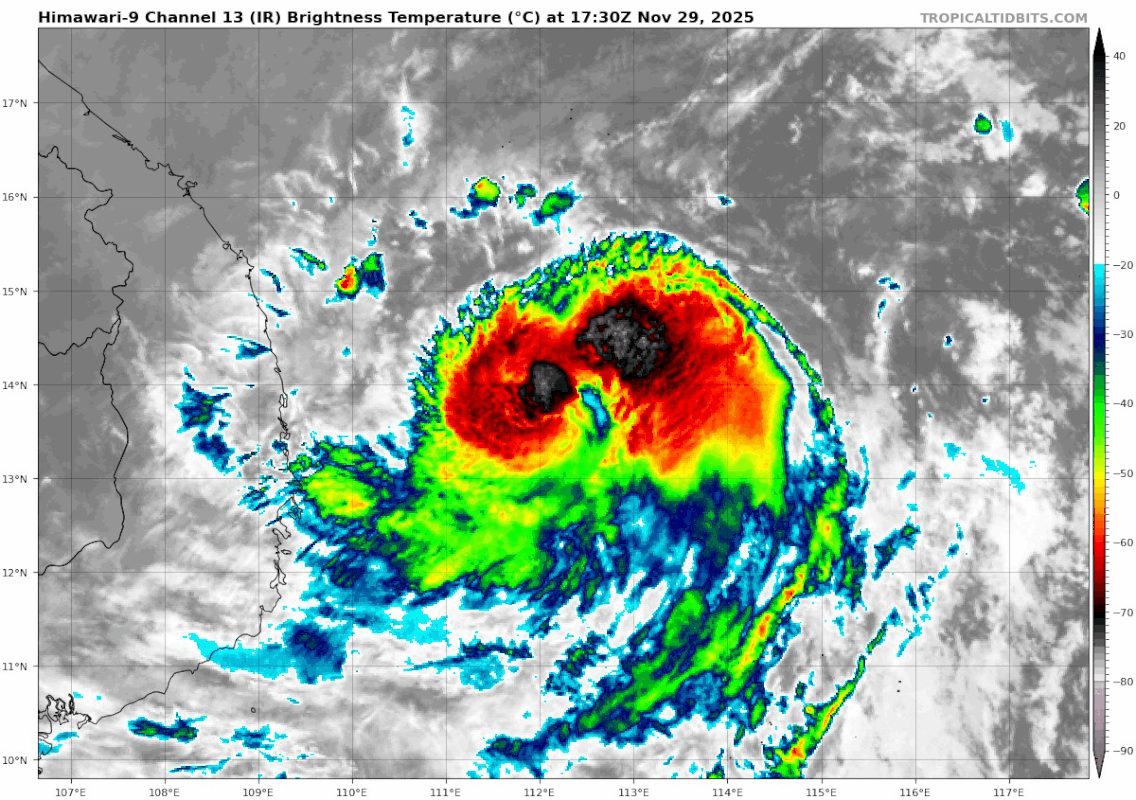
WPAC: Tropical Depression 92W

Detailed discussion and tracking of all WestPac basin storms with special input from staff of our partner site, WesternPacificWeather

Moderators: S2k Moderators, WesternPacificWeatherMods

Forum rules

The posts in this forum are NOT official forecast and should not be used as such. They are just the opinion of the poster and may or may not be backed by sound meteorological data. They are NOT endorsed by any professional institution or STORM2K.

Help Support Storm2K
Message
Author
User avatar
Hayabusa
Category 5
Category 5
Posts: 4808
Joined: Sun Sep 16, 2018 1:05 pm

WPAC: Tropical Depression 92W

#1 Postby Hayabusa » Sat Nov 22, 2025 12:47 pm

92W INVEST 251122 1800 6.0N 134.0E WPAC 15 0

The future storm is now finally an invest
0 likes   
ヤンデレ女が寝取られるているのを見たい!!!
ECMWF ensemble NWPAC plots: https://ecmwfensnwpac.imgbb.com/
Multimodel NWPAC plots: https://multimodelnwpac.imgbb.com/
GFS Ensemble NWPAC plots (16 & 35 day forecast): https://gefsnwpac.imgbb.com/
Plots updated automatically

User avatar
Hayabusa
Category 5
Category 5
Posts: 4808
Joined: Sun Sep 16, 2018 1:05 pm

Re: WPAC: INVEST 92W

#2 Postby Hayabusa » Sat Nov 22, 2025 12:58 pm

Models agree on a TD-TS before landfall and then significantly intensifying while moving slowly over the South China Sea
0 likes   
ヤンデレ女が寝取られるているのを見たい!!!
ECMWF ensemble NWPAC plots: https://ecmwfensnwpac.imgbb.com/
Multimodel NWPAC plots: https://multimodelnwpac.imgbb.com/
GFS Ensemble NWPAC plots (16 & 35 day forecast): https://gefsnwpac.imgbb.com/
Plots updated automatically

User avatar
Hayabusa
Category 5
Category 5
Posts: 4808
Joined: Sun Sep 16, 2018 1:05 pm

Re: WPAC: INVEST 92W

#3 Postby Hayabusa » Sat Nov 22, 2025 1:40 pm

12z deepmind, note on the possible 2nd TC the ensemble is showing coming early December, Euro AI also agrees with the formation on the 2nd TC too.
Image
0 likes   
ヤンデレ女が寝取られるているのを見たい!!!
ECMWF ensemble NWPAC plots: https://ecmwfensnwpac.imgbb.com/
Multimodel NWPAC plots: https://multimodelnwpac.imgbb.com/
GFS Ensemble NWPAC plots (16 & 35 day forecast): https://gefsnwpac.imgbb.com/
Plots updated automatically

User avatar
Hayabusa
Category 5
Category 5
Posts: 4808
Joined: Sun Sep 16, 2018 1:05 pm

Re: WPAC: INVEST 92W

#4 Postby Hayabusa » Sun Nov 23, 2025 9:38 am

Medium
ABPW10 PGTW 231500
MSGID/GENADMIN/JOINT TYPHOON WRNCEN PEARL HARBOR HI//
SUBJ/SIGNIFICANT TROPICAL WEATHER ADVISORY FOR THE WESTERN AND SOUTH
PACIFIC OCEANS REISSUED/231500Z-240600ZNOV2025//
RMKS/
1. WESTERN NORTH PACIFIC AREA (180 TO MALAY PENINSULA):
A. TROPICAL CYCLONE SUMMARY: NONE.
B. TROPICAL DISTURBANCE SUMMARY:
(1) AN AREA OF CONVECTION (INVEST 92W) HAS PERSISTED NEAR 8.7N
132.1E, APPROXIMATELY 171 NM WEST-NORTHWEST OF PALAU. ANIMATED ENHANCED
INFRARED IMAGERY (EIR) AS WELL AS A 230928Z F17 SSMIS 37GHZ MICROWAVE
PASS DEPICT FLARING CONVECTION AROUND A RELATIVELY BROAD CIRCULATION
WITH AREAS OF FORMATIVE BANDING ALONG THE SOUTHERN PERIPHERY OF THE
CIRCULATION. ENVIRONMENTAL CONDITIONS ARE ASSESSED AS MARGINALLY
FAVORABLE WITH LOW TO MODERATE VERTICAL WIND SHEAR (15-20KTS), GOOD
UPPER-LEVEL OUTFLOW AND WARM SEA SURFACE TEMPERATURES (27-29C). GLOBAL
MODELS GENERALLY AGREE THAT THE AREA OF CONVECTION 92W WILL SLOWLY
CONSOLIDATE OVER THE NEXT 36-48 HOURS AS IT TRANSITS OVER THE
PHILIPPINES WITH MUCH MORE PROMINENT DEVELOPMENT IN THE SOUTH CHINA SEA.
MAXIMUM SUSTAINED SURFACE WINDS ARE ESTIMATED AT 13 TO 18 KNOTS. MINIMUM
SEA LEVEL PRESSURE IS ESTIMATED TO BE NEAR 1004 MB. THE POTENTIAL FOR
THE DEVELOPMENT OF A SIGNIFICANT TROPICAL CYCLONE WITHIN THE NEXT 24
HOURS IS MEDIUM.
(2) NO OTHER SUSPECT AREAS.
C. SUBTROPICAL SYSTEM SUMMARY: NONE.
2. SOUTH PACIFIC AREA (WEST COAST OF SOUTH AMERICA TO 135 EAST):
A. TROPICAL CYCLONE SUMMARY: NONE.
B. TROPICAL DISTURBANCE SUMMARY: NONE.
C. SUBTROPICAL SYSTEM SUMMARY: NONE.
3. JUSTIFICATION FOR REISSUE: ADDED MEDIUM AREA IN PARA 1.B.(1)//
NNNN
1 likes   
ヤンデレ女が寝取られるているのを見たい!!!
ECMWF ensemble NWPAC plots: https://ecmwfensnwpac.imgbb.com/
Multimodel NWPAC plots: https://multimodelnwpac.imgbb.com/
GFS Ensemble NWPAC plots (16 & 35 day forecast): https://gefsnwpac.imgbb.com/
Plots updated automatically

User avatar
Hayabusa
Category 5
Category 5
Posts: 4808
Joined: Sun Sep 16, 2018 1:05 pm

Re: WPAC: INVEST 92W

#5 Postby Hayabusa » Sun Nov 23, 2025 1:31 pm

12z deepmind
Image
0 likes   
ヤンデレ女が寝取られるているのを見たい!!!
ECMWF ensemble NWPAC plots: https://ecmwfensnwpac.imgbb.com/
Multimodel NWPAC plots: https://multimodelnwpac.imgbb.com/
GFS Ensemble NWPAC plots (16 & 35 day forecast): https://gefsnwpac.imgbb.com/
Plots updated automatically

User avatar
Hayabusa
Category 5
Category 5
Posts: 4808
Joined: Sun Sep 16, 2018 1:05 pm

Re: WPAC: INVEST 92W

#6 Postby Hayabusa » Sun Nov 23, 2025 1:32 pm

JMA EDA 18Z gave it a CI 1.0, might upgrade to TD now or even a TC warning TD.
0 likes   
ヤンデレ女が寝取られるているのを見たい!!!
ECMWF ensemble NWPAC plots: https://ecmwfensnwpac.imgbb.com/
Multimodel NWPAC plots: https://multimodelnwpac.imgbb.com/
GFS Ensemble NWPAC plots (16 & 35 day forecast): https://gefsnwpac.imgbb.com/
Plots updated automatically

User avatar
Hayabusa
Category 5
Category 5
Posts: 4808
Joined: Sun Sep 16, 2018 1:05 pm

Re: WPAC: INVEST 92W

#7 Postby Hayabusa » Sun Nov 23, 2025 3:31 pm

WWJP27 RJTD 231800
WARNING AND SUMMARY 231800.
WARNING VALID 241800.
WARNING.
TROPICAL DEPRESSION 1002 HPA
AT 09.4N 128.6E SEA EAST OF MINDANAO MOVING WNW 10 KNOTS.
POSITION POOR.
MAX WINDS 30 KNOTS NEAR CENTER.
0 likes   
ヤンデレ女が寝取られるているのを見たい!!!
ECMWF ensemble NWPAC plots: https://ecmwfensnwpac.imgbb.com/
Multimodel NWPAC plots: https://multimodelnwpac.imgbb.com/
GFS Ensemble NWPAC plots (16 & 35 day forecast): https://gefsnwpac.imgbb.com/
Plots updated automatically

User avatar
Hayabusa
Category 5
Category 5
Posts: 4808
Joined: Sun Sep 16, 2018 1:05 pm

Re: WPAC: Tropical Depression 92W

#8 Postby Hayabusa » Sun Nov 23, 2025 10:15 pm

Image
TD a
Issued at 2025/11/24 01:15 UTC
Analysis at 11/24 00 UTC
Grade TD
Scale -
Intensity -
Center position N9°30′ (9.5°)
E128°10′ (128.2°)
Direction and speed of movement W 10 km/h (6 kt)
Central pressure 1002 hPa
Maximum sustained wind speed near center 15 m/s (30 kt)
Maximum wind gust speed 23 m/s (45 kt)
Forecast for 11/24 12 UTC
Grade TD
Intensity -
Center position of probability circle N10°10′ (10.2°)
E125°50′ (125.8°)
Direction and speed of movement WNW 20 km/h (12 kt)
Central pressure 1002 hPa
Maximum sustained wind speed near center 15 m/s (30 kt)
Maximum wind gust speed 23 m/s (45 kt)
Radius of probability circle 100 km (55 NM)
Forecast for 11/25 00 UTC
Grade TS
Intensity -
Center position of probability circle N11°20′ (11.3°)
E123°35′ (123.6°)
Direction and speed of movement WNW 20 km/h (12 kt)
Central pressure 1000 hPa
Maximum sustained wind speed near center 18 m/s (35 kt)
Maximum wind gust speed 25 m/s (50 kt)
Radius of probability circle 130 km (70 NM)
Forecast for 11/26 00 UTC
Grade TS
Intensity -
Center position of probability circle N11°25′ (11.4°)
E118°05′ (118.1°)
Direction and speed of movement W 25 km/h (13 kt)
Central pressure 996 hPa
Maximum sustained wind speed near center 20 m/s (40 kt)
Maximum wind gust speed 30 m/s (60 kt)
Radius of probability circle 200 km (110 NM)
Forecast for 11/27 00 UTC
Grade TS
Intensity -
Center position of probability circle N11°50′ (11.8°)
E114°20′ (114.3°)
Direction and speed of movement W 15 km/h (9 kt)
Central pressure 992 hPa
Maximum sustained wind speed near center 23 m/s (45 kt)
Maximum wind gust speed 35 m/s (65 kt)
Radius of probability circle 260 km (140 NM)
Forecast for 11/28 00 UTC
Grade STS
Intensity -
Center position of probability circle N10°55′ (10.9°)
E112°25′ (112.4°)
Direction and speed of movement WSW Slow
Central pressure 990 hPa
Maximum sustained wind speed near center 25 m/s (50 kt)
Maximum wind gust speed 35 m/s (70 kt)
Radius of probability circle 330 km (180 NM)
Forecast for 11/29 00 UTC
Grade STS
Intensity -
Center position of probability circle N10°10′ (10.2°)
E111°00′ (111.0°)
Direction and speed of movement WSW Slow
Central pressure 990 hPa
Maximum sustained wind speed near center 25 m/s (50 kt)
Maximum wind gust speed 35 m/s (70 kt)
Radius of probability circle 440 km (240 NM)
0 likes   
ヤンデレ女が寝取られるているのを見たい!!!
ECMWF ensemble NWPAC plots: https://ecmwfensnwpac.imgbb.com/
Multimodel NWPAC plots: https://multimodelnwpac.imgbb.com/
GFS Ensemble NWPAC plots (16 & 35 day forecast): https://gefsnwpac.imgbb.com/
Plots updated automatically


Return to “Active Storms - WestPAC/Asia”

Who is online

Users browsing this forum: No registered users and 95 guests