EPAC: EMILIA - Post-Tropical

Moderator: S2k Moderators

Message
Author
User avatar
brunota2003
S2K Supporter
S2K Supporter
Posts: 9476
Age: 33
Joined: Sat Jul 30, 2005 9:56 pm
Location: Stanton, KY...formerly Havelock, NC
Contact:

#101 Postby brunota2003 » Mon Jul 09, 2012 1:27 am

09/0600 UTC 12.0N 109.0W T4.0/4.0 EMILIA

Still waiting for the 06Z BT to come out...I think they are considering an upgrade.

EDIT: Maybe the forecaster fell asleep :lol:
0 likes   
Just a small town southern boy helping other humans.

User avatar
brunota2003
S2K Supporter
S2K Supporter
Posts: 9476
Age: 33
Joined: Sat Jul 30, 2005 9:56 pm
Location: Stanton, KY...formerly Havelock, NC
Contact:

#102 Postby brunota2003 » Mon Jul 09, 2012 1:46 am

And the EPAC has another hurricane!

EP, 05, 2012070906, , BEST, 0, 118N, 1088W, 65, 987, HU

Also of note...they did edit the BT:

EP, 05, 2012070818, , BEST, 0, 112N, 1067W, 50, 997, TS
EP, 05, 2012070900, , BEST, 0, 115N, 1078W, 55, 994, TS
Last edited by brunota2003 on Mon Jul 09, 2012 1:51 am, edited 1 time in total.
0 likes   
Just a small town southern boy helping other humans.

User avatar
Kingarabian
S2K Supporter
S2K Supporter
Posts: 15461
Joined: Sat Aug 08, 2009 3:06 am
Location: Honolulu, Hawaii

#103 Postby Kingarabian » Mon Jul 09, 2012 1:50 am

Woo gotta love fish.
0 likes   
RIP Kobe Bryant

User avatar
Kingarabian
S2K Supporter
S2K Supporter
Posts: 15461
Joined: Sat Aug 08, 2009 3:06 am
Location: Honolulu, Hawaii

#104 Postby Kingarabian » Mon Jul 09, 2012 4:00 am

000
WTPZ45 KNHC 090857
TCDEP5

HURRICANE EMILIA DISCUSSION NUMBER 7
NWS NATIONAL HURRICANE CENTER MIAMI FL EP052012
200 AM PDT MON JUL 09 2012

THE INNER CORE CONVECTIVE CLOUD PATTERN HAS CONTINUED TO IMPROVE AND
A LARGE CENTRAL DENSE OVERCAST FEATURE HAS DEVELOPED. A 09/0330 UTC
SSMIS OVERPASS ALSO INDICATED A LOW- AND MID-LEVEL EYE FEATURE HAD
DEVELOPED. BASED ON THIS INFORMATION AND A CONSENSUS T4.0/65 KT
SATELLITE INTENSITY ESTIMATE FROM TAFB AND SAB...EMILIA HAS BEEN
UPGRADED TO HURRICANE STATUS ON THIS ADVISORY.

TRENDING THROUGH ALL OF THE WOBBLES IN THE CONVENTIONAL AND
MICROWAVE SATELLITE FIXES OVER THE PAST 12 HOURS YIELDS AN INITIAL
MOTION ESTIMATE OF 285/10 KT. THERE REMAINS NO SIGNIFICANT CHANGE
TO THE PREVIOUS FORECAST TRACK OR REASONING. EMILIA IS EXPECTED TO
MOVE GENERALLY WEST-NORTHWESTWARD THROUGHOUT THE FORECAST PERIOD AS
THE HURRICANE MOVES ALONG THE SOUTHERN PERIPHERY OF A DEEP-LAYER
SUBTROPICAL RIDGE SITUATED TO THE NORTH OF THE CYCLONE. THE NHC
GUIDANCE IS IN GOOD AGREEMENT THROUGH 36-48 HOURS...BUT THEN
DIVERGES AFTER THAT WITH THE UKMET TAKING EMILIA DUE WEST AND THE
GFS...GFS-ENSEMBLE...AND NOGAPS MODELS TAKING THE HURRICANE MORE
TOWARD THE NORTHWEST. THE ECMWF MODEL HAS NOW SHIFTED FROM SOUTH OF
TO SLIGHTLY NORTH OF THE PREVIOUS FORECAST TRACK. GIVEN THE
DISTINCT NORTHWARD-BIAS OF THE GFS MODEL WITH HURRICANE DANIEL...
THE OFFICIAL FORECAST TRACK IS WELL SOUTH OF THE GFS SOLUTION AND
IS SIMILAR TO THE ECMWF MODEL AND THE CONSENSUS MODEL TV15.

BASED ON THE TIGHT INNER CORE NOTED IN RECENT MICROWAVE IMAGERY...
LOW VERTICAL WIND SHEAR CONDITIONS...AND AN IMPRESSIVE UPPER-LEVEL
OUTFLOW PATTERN THAT CONTINUES TO EXPAND IN ALL QUADRANTS...RAPID
INTENSIFICATION IS FORECAST TO OCCUR DURING THE NEXT 24 HOURS. THIS
SCENARIO IS ALSO SUPPORTED BY THE SHIPS AND FSSE/FLORIDA STATE
SUPERENSEMBLE MODELS...WHICH ARE FORECASTING AN INCREASE OF 32 KT
AND 33 KT...RESPECTIVELY...DURING THE NEXT 24 HOURS. AFTER
THAT...THE VERTICAL SHEAR IS FORECAST TO INCREASE TO AT LEAST 15
KT...WHICH SHOULD ACT TO LEVEL OFF THE STRENGTHENING PROCESS UNTIL
EMILIA REACHES COOLER WATERS BY ABOUT 72 HOURS. BY DAYS 4 AND 5...
THE COMBINATION OF THE COOLER SEA-SURFACE TEMPERATURES AND A MORE
STABLE ENVIRONMENT SHOULD INDUCE STEADY WEAKENING. THE OFFICIAL
INTENSITY FORECAST CLOSE FOLLOWS A BLEND OF THE SHIPS AND FSSE
INTENSITY MODELS.

FORECAST POSITIONS AND MAX WINDS

INIT 09/0900Z 11.9N 109.3W 65 KT 75 MPH
12H 09/1800Z 12.4N 110.9W 80 KT 90 MPH
24H 10/0600Z 13.0N 113.0W 95 KT 110 MPH
36H 10/1800Z 13.5N 114.9W 100 KT 115 MPH
48H 11/0600Z 13.9N 116.7W 105 KT 120 MPH
72H 12/0600Z 14.6N 120.0W 100 KT 115 MPH
96H 13/0600Z 15.4N 124.0W 80 KT 90 MPH
120H 14/0600Z 16.4N 129.0W 65 KT 75 MPH

$$
FORECASTER STEWART
0 likes   
RIP Kobe Bryant

User avatar
cycloneye
Admin
Admin
Posts: 139596
Age: 67
Joined: Thu Oct 10, 2002 10:54 am
Location: San Juan, Puerto Rico

Re: EPAC: EMILIA - Hurricane

#105 Postby cycloneye » Mon Jul 09, 2012 6:12 am

On boy,she is doing the RI now. Now the overall structure looks much more rounded and not elongated as it was on Sunday.

Image

Image
0 likes   
Visit the Caribbean-Central America Weather Thread where you can find at first post web cams,radars
and observations from Caribbean basin members Click Here

User avatar
Cyclenall
Category 5
Category 5
Posts: 6628
Joined: Thu Jun 08, 2006 10:01 pm
Location: Ontario, Canada

Re: EPAC: EMILIA - Hurricane

#106 Postby Cyclenall » Mon Jul 09, 2012 7:06 am

Personal Forecast Disclaimer:
The posts in this forum are NOT official forecast and should not be used as such. They are just the opinion of the poster and may or may not be backed by sound meteorological data. They are NOT endorsed by any professional institution or storm2k.org. For official information, please refer to the NHC and NWS products.


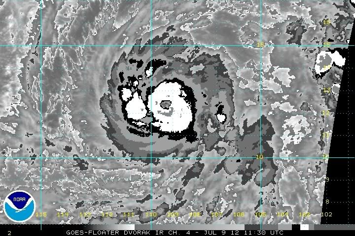
cycloneye wrote:On boy,she is doing the RI now. Now the overall structure looks much more rounded and not elongated as it was on Sunday.

Its been going through RI since yesterday afternoon but just barely because it was starting to accelerate early today. What I'm describing may not officially be called RI but that's the starting point IMO. Now its definitely going through RI and might be the start of the explosive intensification phase because that eye just suddenly appeared within only a couple frames. With that, the convection surrounding it is close to a category 4 type hurricane so this thing is going to just go nuts!! :) Now is the pivotal time when we'll find out if Emilia will become a CAT2, CAT3, or CAT4 hurricane. I'm not going to mention CAT5 yet unless the EI continues all today.

The hurricane has been following what I'd expect yesterday very closely as I believe it became a hurricane a bit eariler than what the NHC said and went to about 75 knots around 5:00 am EDT. I think currently its a category 2 hurricane around 90-95 knots based on the incredible deep ring of convection surrounding an increasingly round eye (not cleared) with a vastly improved outflow pattern. If that eye totally clears out in a matter of hours, CAT4 status would not be far away at all. I expect ADT numbers along with others to start skyrocketing starting 1 hour ago.
0 likes   

RL3AO
Moderator-Pro Met
Moderator-Pro Met
Posts: 16308
Joined: Thu Jun 14, 2007 10:03 pm
Location: NC

#107 Postby RL3AO » Mon Jul 09, 2012 7:17 am

I'm going to say 135kt peak. NHC doesn't like going 140+ without recon or T7.0's across the board.


Personal Forecast Disclaimer:
The posts in this forum are NOT official forecast and should not be used as such. They are just the opinion of the poster and may or may not be backed by sound meteorological data. They are NOT endorsed by any professional institution or storm2k.org. For official information, please refer to the NHC and NWS products.
0 likes   

RL3AO
Moderator-Pro Met
Moderator-Pro Met
Posts: 16308
Joined: Thu Jun 14, 2007 10:03 pm
Location: NC

#108 Postby RL3AO » Mon Jul 09, 2012 7:21 am

While I know nothing about actually applying the Dvorak technique, I do know that a rapidly warming eye and thick ring of white with cold medium grey convection is certainly not a 65kt storm.

Image

I'd say 90 to 95. Eye starts to become round at 100-105 and then nearly a perfect circle by 115kt.
0 likes   

RL3AO
Moderator-Pro Met
Moderator-Pro Met
Posts: 16308
Joined: Thu Jun 14, 2007 10:03 pm
Location: NC

#109 Postby RL3AO » Mon Jul 09, 2012 7:31 am

CI# /Pressure/ Vmax
4.1 / 987.8mb/ 67.4kt


Final T# Adj T# Raw T#
4.1 5.6 6.1

Look at that raw T#
0 likes   

User avatar
cycloneye
Admin
Admin
Posts: 139596
Age: 67
Joined: Thu Oct 10, 2002 10:54 am
Location: San Juan, Puerto Rico

Re: EPAC: EMILIA - Hurricane

#110 Postby cycloneye » Mon Jul 09, 2012 7:35 am

Not quite the 90kts on SSD Dvorak but 75-80kts.

09/1200 UTC 12.4N 109.4W T4.5/4.5 EMILIA
0 likes   
Visit the Caribbean-Central America Weather Thread where you can find at first post web cams,radars
and observations from Caribbean basin members Click Here

User avatar
cycloneye
Admin
Admin
Posts: 139596
Age: 67
Joined: Thu Oct 10, 2002 10:54 am
Location: San Juan, Puerto Rico

Re: EPAC: EMILIA - Hurricane

#111 Postby cycloneye » Mon Jul 09, 2012 7:58 am

12z Best Track at 85kts

EP, 05, 2012070912, , BEST, 0, 124N, 1094W, 85, 977, HU

ftp://ftp.nhc.noaa.gov/atcf/tcweb/inves ... 012.invest
0 likes   
Visit the Caribbean-Central America Weather Thread where you can find at first post web cams,radars
and observations from Caribbean basin members Click Here

User avatar
Cyclenall
Category 5
Category 5
Posts: 6628
Joined: Thu Jun 08, 2006 10:01 pm
Location: Ontario, Canada

Emilia going Bonkers

#112 Postby Cyclenall » Mon Jul 09, 2012 8:05 am

RL3AO wrote:While I know nothing about actually applying the Dvorak technique, I do know that a rapidly warming eye and thick ring of white with cold medium grey convection is certainly not a 65kt storm.

*Image Cut*

I'd say 90 to 95. Eye starts to become round at 100-105 and then nearly a perfect circle by 115kt.

NOT OFFICIAL: Yeah, it was 65 knots a long time ago now. Its almost certain the BT will be edited in short order. That image might be a major.

I can't wait for the first visible and the next advisory intensity because we might be looking at one of the largest 6-hour jumps operationally we've seen in years. I have visions of 50 knots upwards from 5:00 am!

RL3AO wrote:CI# /Pressure/ Vmax
4.1 / 987.8mb/ 67.4kt


Final T# Adj T# Raw T#
4.1 5.6 6.1

Look at that raw T#

Yep, I knew they would start skyrocketing as soon as that eye came out. I would laugh so hard if it says 7.0 by 11 am EDT.

As far as my prediction for peak intensity, I'm not too sure but I'll go with 135 knots too for now.
0 likes   

User avatar
cycloneye
Admin
Admin
Posts: 139596
Age: 67
Joined: Thu Oct 10, 2002 10:54 am
Location: San Juan, Puerto Rico

Re: EPAC: EMILIA - Hurricane

#113 Postby cycloneye » Mon Jul 09, 2012 8:21 am

The 12z SHIP RI forecast increases in this run.

Prob of RI for 25 kt RI threshold= 59% is 4.8 times the sample mean(11.7%)
Prob of RI for 30 kt RI threshold= 52% is 7.1 times the sample mean( 7.9%)
Prob of RI for 35 kt RI threshold= 49% is 8.8 times the sample mean( 5.4%)
Prob of RI for 40 kt RI threshold= 49% is 17.9 times the sample mean( 3.9%)

ftp://ftp.nhc.noaa.gov/atcf/stext/12070 ... _ships.txt
0 likes   
Visit the Caribbean-Central America Weather Thread where you can find at first post web cams,radars
and observations from Caribbean basin members Click Here

User avatar
Yellow Evan
Professional-Met
Professional-Met
Posts: 15960
Age: 25
Joined: Fri Jul 15, 2011 12:48 pm
Location: Henderson, Nevada/Honolulu, HI
Contact:

#114 Postby Yellow Evan » Mon Jul 09, 2012 8:45 am

Wow, I wake up, and Emilia is a Cat 2. EI is coming.
Last edited by Yellow Evan on Mon Jul 09, 2012 10:20 am, edited 1 time in total.
0 likes   

User avatar
Cyclenall
Category 5
Category 5
Posts: 6628
Joined: Thu Jun 08, 2006 10:01 pm
Location: Ontario, Canada

Older Posts

#115 Postby Cyclenall » Mon Jul 09, 2012 8:50 am

OLDER RESPONSES:

cycloneye wrote:NHC now forecasts major hurricane.Cyclenall,what do you think of them going that far high as we know they go conservative?

I think now they might have been conservative there still. I know the NHC was itching to get this thing up to 100 knots but now they're going to be itching to go up even higher.

Yellow Evan wrote:Rick 09 formed faster.

If we're comparing this to Rick, then Emilia must be doing pretty darn good!

TropicalAnalystwx13 wrote:
The following post is NOT an official forecast and should not be used as such. It is just the opinion of the poster and may or may not be backed by sound meteorological data. It is NOT endorsed by any professional institution including storm2k.org. For Official Information please refer to the NHC and NWS products.


Upper-level outflow with the storm has blossomed over the past few hours. With a seemingly-endless list of things favoring rapid intensification, we should see a major hurricane by tomorrow night. It would not surprise me in the slightest to see Emilia become a Category 5 on Tuesday.

I'm starting to wonder if that last part is on the nose.

brunota2003 wrote:
brunota2003 wrote:Well...looking through the latest, RI may begin within the next 6 to 10 hours. I really don't have time to work with (sitting in an airport), so I'm just going to throw a quick guess out there...90 knots by 11 am tomorrow morning (going to start the 24 hours at 11 am). We'll see how close I am!

Could a mod add the disclaimer? Thanks.

Well, on a computer so I can post a little more now (dial up though...yayy lol).

I'm still sticking with 90 knots by the 11 am advisory, however I believe the real RI is just about to begin. Looking through the latest and greatest, the main RI should begin between 2 and 4 am...and I expect that by the 11 pm advisory tomorrow, Emilia will be pushing 110 or 115 knots. After that, the intensification will slow down...and I can see a peak of 125 or 130 knots.

Your pretty much exactly correct here. This is the third time you have completely nailed a RI forecast.
0 likes   

User avatar
TropicalAnalystwx13
Category 5
Category 5
Posts: 2109
Age: 26
Joined: Tue Jul 19, 2011 8:20 pm
Location: Wilmington, NC
Contact:

#116 Postby TropicalAnalystwx13 » Mon Jul 09, 2012 9:43 am

Image
0 likes   

User avatar
Yellow Evan
Professional-Met
Professional-Met
Posts: 15960
Age: 25
Joined: Fri Jul 15, 2011 12:48 pm
Location: Henderson, Nevada/Honolulu, HI
Contact:

Re: Older Posts

#117 Postby Yellow Evan » Mon Jul 09, 2012 9:44 am

Cyclenall wrote:
Yellow Evan wrote:Rick 09 formed faster.

If we're comparing this to Rick, then Emilia must be doing pretty darn good!


Not as amazing as Rick though. Rick was insane.
0 likes   

User avatar
Yellow Evan
Professional-Met
Professional-Met
Posts: 15960
Age: 25
Joined: Fri Jul 15, 2011 12:48 pm
Location: Henderson, Nevada/Honolulu, HI
Contact:

Re:

#118 Postby Yellow Evan » Mon Jul 09, 2012 9:45 am

TropicalAnalystwx13 wrote:Image


Eye looks open on the NNE side.
0 likes   

User avatar
cycloneye
Admin
Admin
Posts: 139596
Age: 67
Joined: Thu Oct 10, 2002 10:54 am
Location: San Juan, Puerto Rico

Re: EPAC: EMILIA - Hurricane

#119 Postby cycloneye » Mon Jul 09, 2012 9:54 am

NHC peaks at 115kts.

HURRICANE EMILIA DISCUSSION NUMBER 8
NWS NATIONAL HURRICANE CENTER MIAMI FL EP052012
800 AM PDT MON JUL 09 2012

OVER THE PAST SEVERAL HOURS...EMILIA HAS STRENGTHENED RAPIDLY FROM A
CATEGORY ONE TO A CATEGORY TWO HURRICANE. ALTHOUGH A RAPID
INTENSIFICATION EPISODE HAD BEEN ANTICIPATED...SPECIFYING THE
PRECISE TIMING OF THIS EVENT IS ALWAYS DIFFICULT. THE CURRENT
INTENSITY ESTIMATE OF 85 KT IS BASED ON A BLEND OF SUBJECTIVE
DVORAK ESTIMATES FROM TAFB AND SAB...AND RECENT ADT ESTIMATES
SUGGEST THAT EMILIA MIGHT BE STRONGER. HOWEVER THE EYE HAS BECOME
LESS WELL-DEFINED ON RECENT IR IMAGES...SO IT IS PROBABLY BEST TO
BE A LITTLE CONSERVATIVE ON THE INTENSITY ESTIMATE AT THIS TIME.
EMILIA SHOULD REMAIN OVER WARM WATERS AND IN RELATIVELY LOW
VERTICAL SHEAR FOR THE NEXT COUPLE OF DAYS. WATER VAPOR IMAGERY
SHOWS A WELL-DEFINED UPPER-LEVEL OUTFLOW CHANNEL TO THE NORTH AND
NORTHWEST OF THE HURRICANE. ADDITIONAL RAPID STRENGTHENING SEEMS
LIKELY...AND THE OFFICIAL INTENSITY FORECAST FOR THE NEXT 12 TO 24
HOURS IS ABOVE ALL OF THE NUMERICAL GUIDANCE. ASSUMING AN EYEWALL
REPLACEMENT CYCLE WILL BEGIN WITHIN THE NEXT DAY OR SO...THE
INTENSITY IS FORECAST TO LEVEL OFF AND SLOWLY DECREASE IN 24-36
HOURS. AS ALWAYS...HOWEVER...OUR ABILITY TO PREDICT TROPICAL
CYCLONE INTENSITY CHANGE IS QUITE LIMITED.

EMILIA CONTINUES ON A WEST-NORTHWESTWARD TRACK AND THE CURRENT
MOTION IS ABOUT 290/10. THERE ARE NO SIGNIFICANT CHANGES TO THE
TRACK FORECAST PHILOSOPHY FOR THIS ADVISORY PACKAGE. A
MID-TROPOSPHERIC RIDGE TO THE NORTH OF THE TROPICAL CYCLONE SHOULD
MAINTAIN THE WEST-NORTHWESTWARD MOTION FOR THE NEXT FEW DAYS...
WITH A MORE WESTWARD TRACK LIKELY NEAR THE END OF THE FORECAST
PERIOD. THE OFFICIAL FORECAST TRACK IS SIMILAR TO THE PREVIOUS ONE
AND CLOSE TO THE ECMWF MODEL TRACK PREDICTION. THIS IS A LITTLE TO
THE SOUTH OF THE LATEST GFS SOLUTION.

FORECAST POSITIONS AND MAX WINDS

INIT 09/1500Z 12.6N 109.9W 85 KT 100 MPH
12H 10/0000Z 13.0N 111.4W 110 KT 125 MPH
24H 10/1200Z 13.6N 113.4W 115 KT 130 MPH
36H 11/0000Z 14.1N 115.3W 110 KT 125 MPH
48H 11/1200Z 14.6N 117.2W 105 KT 120 MPH
72H 12/1200Z 15.4N 120.7W 95 KT 110 MPH
96H 13/1200Z 16.3N 124.8W 75 KT 85 MPH
120H 14/1200Z 17.0N 129.5W 60 KT 70 MPH

$$
FORECASTER PASCH
0 likes   
Visit the Caribbean-Central America Weather Thread where you can find at first post web cams,radars
and observations from Caribbean basin members Click Here

User avatar
cycloneye
Admin
Admin
Posts: 139596
Age: 67
Joined: Thu Oct 10, 2002 10:54 am
Location: San Juan, Puerto Rico

Re: EPAC: EMILIA - Hurricane

#120 Postby cycloneye » Mon Jul 09, 2012 10:14 am

Image
0 likes   
Visit the Caribbean-Central America Weather Thread where you can find at first post web cams,radars
and observations from Caribbean basin members Click Here


Return to “2012”

Who is online

Users browsing this forum: No registered users and 9 guests