ATL: CHRIS - Post-Tropical
Moderator: S2k Moderators
-
Florida1118
Re: ATL: INVEST 95L
0 likes
-
Aric Dunn
- Category 5

- Posts: 21238
- Age: 43
- Joined: Sun Sep 19, 2004 9:58 pm
- Location: Ready for the Chase.
- Contact:
its very likely been a TC for the past 24 or more hours. although convention is limited it has been persistent enough.
0 likes
Note: If I make a post that is brief. Please refer back to previous posts for the analysis or reasoning. I do not re-write/qoute what my initial post said each time.
If there is nothing before... then just ask
Space & Atmospheric Physicist, Embry-Riddle Aeronautical University,
I believe the sky is falling...
If there is nothing before... then just ask
Space & Atmospheric Physicist, Embry-Riddle Aeronautical University,
I believe the sky is falling...
-
SouthDadeFish

- Professional-Met

- Posts: 2835
- Joined: Thu Sep 23, 2010 2:54 pm
- Location: Miami, FL
- Contact:

-
TropicalAnalystwx13

- Category 5
- Posts: 2109
- Age: 28
- Joined: Tue Jul 19, 2011 8:20 pm
- Location: Wilmington, NC
- Contact:

-
Florida1118
Re: ATL: INVEST 95L
Either Tropical or Subtropical, it should be named if the convection holds until 5pm. If it isnt named at 5pm with convection I will be surprised; I wouldn't know what would be holding the NHC back. We will see what the 2pm TWO says, and will give us an Idea on whether it will be named or not.
0 likes
-
Aric Dunn
- Category 5
- Posts: 21238
- Age: 43
- Joined: Sun Sep 19, 2004 9:58 pm
- Location: Ready for the Chase.
- Contact:
its almost seems that way.
0 likes
Note: If I make a post that is brief. Please refer back to previous posts for the analysis or reasoning. I do not re-write/qoute what my initial post said each time.
If there is nothing before... then just ask
Space & Atmospheric Physicist, Embry-Riddle Aeronautical University,
I believe the sky is falling...
If there is nothing before... then just ask
Space & Atmospheric Physicist, Embry-Riddle Aeronautical University,
I believe the sky is falling...
-
Aric Dunn
- Category 5
- Posts: 21238
- Age: 43
- Joined: Sun Sep 19, 2004 9:58 pm
- Location: Ready for the Chase.
- Contact:
upgrade should come today. convection for the first time again limited surrounds the center. reminds of many azores systems.
0 likes
Note: If I make a post that is brief. Please refer back to previous posts for the analysis or reasoning. I do not re-write/qoute what my initial post said each time.
If there is nothing before... then just ask
Space & Atmospheric Physicist, Embry-Riddle Aeronautical University,
I believe the sky is falling...
If there is nothing before... then just ask
Space & Atmospheric Physicist, Embry-Riddle Aeronautical University,
I believe the sky is falling...
-
ozonepete
- Professional-Met
- Posts: 4743
- Joined: Mon Sep 07, 2009 3:23 pm
- Location: From Ozone Park, NYC / Now in Brooklyn, NY
Re: ATL: INVEST 95L
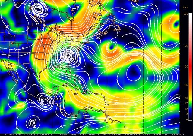
Agree with you guys that it's pretty much been a TC for a while and sure looks like one now. BTW, looks like it's slowed down; if it moves a tad more north it will run into very light steering winds so could slow down or stall. Here's the CIMSS steering for 1000-1010mb storms.
My posts in this forum are NOT official forecast and should not be used as such. They are just the opinion of the poster [me] and may or may not be backed by sound meteorological data. They are NOT endorsed by any professional institution or storm2k.org. For official information, please refer to the NHC and NWS products.
My posts in this forum are NOT official forecast and should not be used as such. They are just the opinion of the poster [me] and may or may not be backed by sound meteorological data. They are NOT endorsed by any professional institution or storm2k.org. For official information, please refer to the NHC and NWS products.
0 likes
-
ozonepete
- Professional-Met
- Posts: 4743
- Joined: Mon Sep 07, 2009 3:23 pm
- Location: From Ozone Park, NYC / Now in Brooklyn, NY
Re:
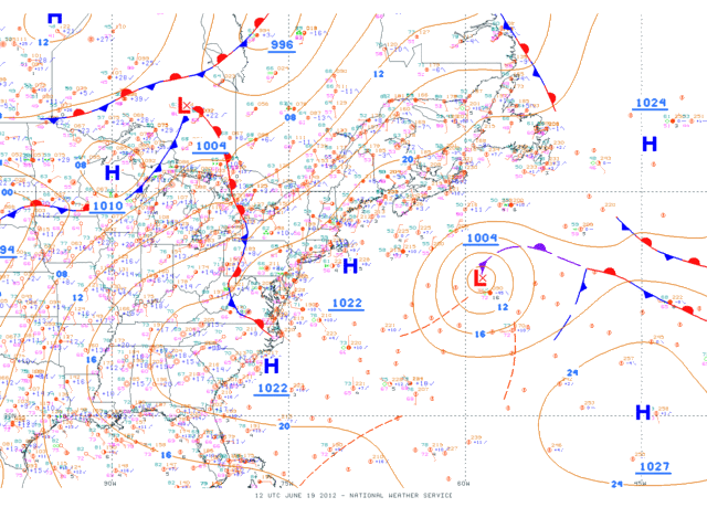
CrazyC83 wrote:Is that a cold front attached to the south?
No. It has a couple of troughs embedded in the circulation and an occluded front on the NE side that is marked as dissipating.
0 likes


Re: ATL: INVEST 95L
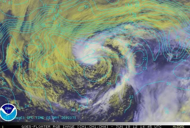
Convection seems to be wrapping around in the latest visible loop:
http://www.ssd.noaa.gov/PS/TROP/floater ... -long.html
http://www.ssd.noaa.gov/PS/TROP/floater ... -long.html
0 likes
-
Florida1118
Re: ATL: INVEST 95L
SHOWERS AND THUNDERSTORMS HAVE BECOME A LITTLE BETTER ORGANIZED WITH
THE LOW PRESSURE SYSTEM LOCATED ABOUT 460 MILES SOUTHEAST OF
HALIFAX NOVA SCOTIA. ALTHOUGH THE THUNDERSTORM ACTIVITY IS
CURRENTLY LIMITED IN EXTENT...THIS SYSTEM HAS THE POTENTIAL TO
DEVELOP INTO A TROPICAL CYCLONE BEFORE IT ENCOUNTERS COOLER WATERS
AND A MORE STABLE ATMOSPHERE IN A DAY OR SO. THIS SYSTEM HAS A
MEDIUM CHANCE...50 PERCENT...OF BECOMING A TROPICAL CYCLONE DURING
THE NEXT 48 HOURS AS IT MOVES EAST-NORTHEASTWARD AT 10 TO 15 MPH.
FOR ADDITIONAL INFORMATION ON THIS SYSTEM...PLEASE SEE HIGH SEAS
FORECASTS ISSUED BY THE OCEAN PREDICTION CENTER.
0 likes
Re: ATL: INVEST 95L
Florida1118 wrote:Doesn't sound like they will upgrade it anytime soon.
Maybe at 5 pm they will put out a special outlook (80-100%) if convection persists?
0 likes
-
Florida1118
Re: ATL: INVEST 95L
bg1 wrote:Florida1118 wrote:Doesn't sound like they will upgrade it anytime soon.
Maybe at 5 pm they will put out a special outlook (80-100%) if convection persists?
In my opinion, if there is no renumber and no storm at 5pm, its over. Who knows, it might be upgraded at 11pm...but 95L is really short on time. This might just be a case of them upgrading post-season. Convection is the only thing that is keeping the NHC from upgrading. They probably wont do a special outlook though, since this is not a threat to any land areas.
0 likes
-
ozonepete
- Professional-Met
- Posts: 4743
- Joined: Mon Sep 07, 2009 3:23 pm
- Location: From Ozone Park, NYC / Now in Brooklyn, NY
Re: ATL: INVEST 95L
0 likes


-
ozonepete
- Professional-Met
- Posts: 4743
- Joined: Mon Sep 07, 2009 3:23 pm
- Location: From Ozone Park, NYC / Now in Brooklyn, NY
Re: ATL: INVEST 95L
Looks like the center has drifted southeastward over the last few hours if you watch the loops.
(or maybe even south-southeastward)
0 likes
-
TropicalAnalystwx13
- Category 5
- Posts: 2109
- Age: 28
- Joined: Tue Jul 19, 2011 8:20 pm
- Location: Wilmington, NC
- Contact:
Who is online
Users browsing this forum: No registered users and 38 guests