ATL: ERNESTO - Post-Tropical

Moderator: S2k Moderators

Message
Author
IreneSurvivor47

Re: ATL: FIVE - Tropical Depression

#561 Postby IreneSurvivor47 » Wed Aug 01, 2012 4:40 pm

ROCK wrote:glad we have our first TD of the season, officially anyway.... :lol:

Does look a bit ragged this evening but a TD nonetheless....I cant wait for the model wars Weather Freak... :lol:

Convection disappearing...slightly.
0 likes   

Stormcenter
S2K Supporter
S2K Supporter
Posts: 6684
Joined: Wed Sep 03, 2003 11:27 am
Location: Houston, TX

Re: ATL: FIVE - Tropical Depression

#562 Postby Stormcenter » Wed Aug 01, 2012 4:40 pm

Way,way,way too early to be concerned about TD #5 if you live in the U.S. IMO

Interesting to see the NHC favoring the GFS clearly over the European model in reference to future strengthening.

We shall see.
0 likes   

User avatar
Hurricaneman
Category 5
Category 5
Posts: 7351
Age: 45
Joined: Tue Aug 31, 2004 3:24 pm
Location: central florida

Re: ATL: FIVE - Tropical Depression

#563 Postby Hurricaneman » Wed Aug 01, 2012 4:44 pm

IreneSurvivor47 wrote:
PTrackerLA wrote:This part of the NHC discussion is particularly alarming with the NW movement and weakness in the gulf mentioned. Could be the same weakness returning to the Gulf states that has given us a very wet summer?

THE INITIAL MOTION IS A SOMEWHAT UNCERTAIN 285/16. GLOBAL MODELS
DEPICT A STRONG MID-TROPOSPHERIC ANTICYCLONE TO THE NORTH OF THE
TROPICAL CYCLONE FOR THE NEXT SEVERAL DAYS. THIS STEERING PATTERN
SHOULD CAUSE A WEST-NORTHWESTWARD TO WESTWARD MOTION AT ABOUT THE
SAME SPEED THROUGH MUCH OF THE FORECAST PERIOD. A WEAKNESS OVER
THE GULF OF MEXICO COULD CAUSE SOME SLOWING AND BIT OF A
NORTHWESTWARD TURN LATE IN THE PERIOD. THE COMPUTER MODELS ARE IN
GOOD AGREEMENT...AND THE NHC TRACK FORECAST IS NOT FAR FROM THE
MODEL CONSENSUS.

In other words the storm will curve out to sea or be an east coast storm? Sorry, didn't understand that.


Not necessarily, it basically opens up the possibility that anywhere in the Gulf could be a landfall point. The only thing that seems to have a consensus is that it heads WNW towards Jamaica, but from there it could go west into the Yucatan or north into the Florida Panhandle or even Tampa, its just wait and see for the next week

The posts in this forum are NOT official forecast and should not be used as such. They are just the opinion of the poster and may or may not be backed by sound meteorological data. They are NOT endorsed by any professional institution or storm2k.org. For official information, please refer to the NHC and NWS products
0 likes   

User avatar
SFLcane
S2K Supporter
S2K Supporter
Posts: 10163
Age: 47
Joined: Sat Jun 05, 2010 1:44 pm
Location: Lake Worth Florida

Re: ATL: FIVE - Tropical Depression

#564 Postby SFLcane » Wed Aug 01, 2012 4:46 pm

Hurricane Alexis wrote:So what are the chances it makes a run towards Florida in the next 10 days?


With a long wave trough over the eastern conus i'd keep tabs on it.
0 likes   

User avatar
ROCK
Category 5
Category 5
Posts: 9484
Age: 54
Joined: Tue Aug 17, 2004 7:30 am
Location: Kemah, Texas

Re: Re:

#565 Postby ROCK » Wed Aug 01, 2012 4:46 pm

Weatherfreak000 wrote:
gatorcane wrote:Pretty decent north shift in the 18Z package? :darrow:

http://www.ral.ucar.edu/hurricanes/real ... _early.png


Models on the North end of that envelope I take with a grain of salt...... CLP5? BAMM? LBAR? Think i'll pass :lol:


IMO, the question here is North of Jamaica....or South?


I agree....the CMC has slowly shifted south each run but still above the islands and into the Bahamas. Those other models are garbage....The NOGAPS is still the right outlier and is way right....
0 likes   

hurricanes1234
Category 5
Category 5
Posts: 2907
Joined: Sat Jul 28, 2012 6:19 pm
Location: Trinidad and Tobago

Re: ATL: FIVE - Tropical Depression

#566 Postby hurricanes1234 » Wed Aug 01, 2012 4:46 pm

Image Image

Image of the storm on July 30, compared to earlier today, before becoming a tropical depression this afternoon at 5 PM. :ggreen:
Last edited by hurricanes1234 on Wed Aug 01, 2012 4:48 pm, edited 1 time in total.
0 likes   
PLEASE NOTE: With the exception of information from weather agencies that I may copy and paste here, my posts will NEVER be official, since I am NOT a meteorologist. They are solely my amateur opinion, and may or may not be accurate. Therefore, please DO NOT use them as official details, particularly when making important decisions. Thank you.

User avatar
cycloneye
Admin
Admin
Posts: 145327
Age: 68
Joined: Thu Oct 10, 2002 10:54 am
Location: San Juan, Puerto Rico

Re: ATL: FIVE - Tropical Depression

#567 Postby cycloneye » Wed Aug 01, 2012 4:47 pm

Already one NWS office in the GOM discussing about TD Five.

Here is Mobile,Ala

AREA FORECAST DISCUSSION
NATIONAL WEATHER SERVICE MOBILE AL
352 PM CDT WED AUG 1 2012


THE WEAKNESS BETWEEN THE UPPER RIDGE OVER TEXAS AND THE UPPER RIDGE
OVER THE WEST ATLANTIC WILL CONTINUE THROUGH AT LEAST EARLY NEXT
WEEK...WITH GUIDANCE ATTEMPTING TO STRENGTHEN THE RIDGE BY THE MIDDLE
OF NEXT WEEK. THERE IS A LOT OF UNCERTAINTY REGARDING HOW STRONG THE
RIDGE WILL BUILD IN AS THE AFOREMENTIONED WEAKNESS HAS BEEN A
PERSISTENT FEATURE OVER OUR AREA OVER THE LAST SEVERAL WEEKS. DID NOT
DEVIATE FROM THE PREVIOUS FORECAST...WHICH SHOWS LITTLE CHANGE IN
TEMPS AND CONTINUED 30-40 POPS EACH DAY.

TROPICAL DEPRESSION FIVE HAS DEVELOPED EAST OF THE WINDWARD ISLANDS
AND IS FORECAST TO MOVE WEST INTO THE CENTRAL CARIBBEAN BY MONDAY.
THIS SYSTEM WILL CERTAINLY HAVE NO IMPACT OVER US THROUGH THE NEXT 7
DAYS...BUT WILL BEAR WATCHING AS IT APPROACHES THE YUCATAN BY THE
MIDDLE-END OF NEXT WEEK. THE ULTIMATE DIRECTION OF THE SYSTEM WILL
HINGE ON HOW MUCH HEIGHTS BUILD OVER THE CENTRAL GULF/SE STATE LATE
NEXT WEEK. PLENTY OF TIME TO MONITOR.
34/JFB
0 likes   
Visit the Caribbean-Central America Weather Thread where you can find at first post web cams,radars
and observations from Caribbean basin members Click Here

User avatar
northjaxpro
S2K Supporter
S2K Supporter
Posts: 8900
Joined: Mon Sep 27, 2010 11:21 am
Location: Jacksonville, FL

Re: ATL: FIVE - Tropical Depression

#568 Postby northjaxpro » Wed Aug 01, 2012 4:48 pm

Stormcenter wrote:Way,way,way too early to be concerned about TD #5 if you live in the U.S. IMO

Interesting to see the NHC favoring the GFS clearly over the European model in reference to future strengthening.

We shall see.


I agree. We have plenty of time in the U.S. to monitor this system and lots of variables to analyze as usual beyond the next five days. My best wishes to those in the Leeward and Windward Islands with their preparations first and foremost as this is forecast to impact them as early as late Friday evening into early Saturday.
Last edited by northjaxpro on Wed Aug 01, 2012 4:53 pm, edited 1 time in total.
0 likes   
NEVER, EVER SAY NEVER in the tropics and weather in general, and most importantly, with life itself!!

________________________________________________________________________________________

Fay 2008 Beryl 2012 Debby 2012 Colin 2016 Hermine 2016 Julia 2016 Matthew 2016 Irma 2017 Dorian 2019

User avatar
ROCK
Category 5
Category 5
Posts: 9484
Age: 54
Joined: Tue Aug 17, 2004 7:30 am
Location: Kemah, Texas

#569 Postby ROCK » Wed Aug 01, 2012 4:52 pm

18Z NOGAPS coming in...you can see it here....

https://www.fnmoc.navy.mil/wxmap_cgi/cg ... t=Tropical
0 likes   

User avatar
KatDaddy
Category 5
Category 5
Posts: 2815
Joined: Mon Oct 21, 2002 6:23 pm
Location: League City, Texas

#570 Postby KatDaddy » Wed Aug 01, 2012 4:52 pm

Time to start watching TD 5 soon to be Ernesto closely. We may have a hurricane in the NW Caribbean Sea by Monday according to the HNC forecast path. At least we have many days to watch the developments.
0 likes   
The following post is NOT an official forecast and should not be used as such. It is just the opinion of the poster and may or may not be backed by sound meteorological data. It is NOT endorsed by any professional institution including storm2k.org For Official Information please refer to the NHC and NWS products.

User avatar
PTrackerLA
Category 5
Category 5
Posts: 5277
Age: 41
Joined: Thu Oct 10, 2002 8:40 pm
Location: Lafayette, LA

#571 Postby PTrackerLA » Wed Aug 01, 2012 4:53 pm

Of course the initial concern is the islands but as of right now it shouldn't be too significant of an impact given the current forecast. Afterwards, well, it has been a few years since we've had a CV system possibly approach the GOM from this direction. If Ernesto is a hurricane near Jamaica on monday and starting to bend NW all hell is going to break loose around here :lol: . Still many days to watch.
0 likes   

hurricanes1234
Category 5
Category 5
Posts: 2907
Joined: Sat Jul 28, 2012 6:19 pm
Location: Trinidad and Tobago

Re: ATL: FIVE - Tropical Depression

#572 Postby hurricanes1234 » Wed Aug 01, 2012 4:54 pm

Does anyone know why the satellite images keep blacking out so often? Look at any of the available satellite loops for TD 5 and you'll see what I mean.
0 likes   
PLEASE NOTE: With the exception of information from weather agencies that I may copy and paste here, my posts will NEVER be official, since I am NOT a meteorologist. They are solely my amateur opinion, and may or may not be accurate. Therefore, please DO NOT use them as official details, particularly when making important decisions. Thank you.

tolakram
Admin
Admin
Posts: 20009
Age: 62
Joined: Sun Aug 27, 2006 8:23 pm
Location: Florence, KY (name is Mark)

Re: ATL: FIVE - Tropical Depression

#573 Postby tolakram » Wed Aug 01, 2012 4:57 pm

hurricanes1234 wrote:Does anyone know why the satellite images keep blacking out so often? Look at any of the available satellite loops for TD 5 and you'll see what I mean.


Some of the channels are worse than others. If you look at the big picture you'll see it's only part of the image that's missing, usually near the edges.

http://wwwghcc.msfc.nasa.gov/cgi-bin/ge ... mframes=10
0 likes   
M a r k
- - - - -
Join us in chat: Storm2K Chatroom Invite. Android and IOS apps also available.

The posts in this forum are NOT official forecasts and should not be used as such. Posts are NOT endorsed by any professional institution or STORM2K.org. For official information and forecasts, please refer to NHC and NWS products.

User avatar
northjaxpro
S2K Supporter
S2K Supporter
Posts: 8900
Joined: Mon Sep 27, 2010 11:21 am
Location: Jacksonville, FL

Re:

#574 Postby northjaxpro » Wed Aug 01, 2012 5:00 pm

PTrackerLA wrote:Of course the initial concern is the islands but as of right now it shouldn't be too significant of an impact given the current forecast. Afterwards, well, it has been a few years since we've had a CV system possibly approach the GOM from this direction. If Ernesto is a hurricane near Jamaica on monday and starting to bend NW all hell is going to break loose around here :lol: . Still many days to watch.


Sure, if that were the case, I am sure it will be buzzing on the blog and the media. However, I will worry or speculate about that if we get to that point. A lot can happen between now and Monday. Monitor TD 5 for now, and this weekend is when I will really begin the hone in on it if it potentially strengthens into a potent tropical cyclone and enters the Caribbean as forecast.
0 likes   
NEVER, EVER SAY NEVER in the tropics and weather in general, and most importantly, with life itself!!

________________________________________________________________________________________

Fay 2008 Beryl 2012 Debby 2012 Colin 2016 Hermine 2016 Julia 2016 Matthew 2016 Irma 2017 Dorian 2019

User avatar
ROCK
Category 5
Category 5
Posts: 9484
Age: 54
Joined: Tue Aug 17, 2004 7:30 am
Location: Kemah, Texas

Re: ATL: FIVE - Tropical Depression

#575 Postby ROCK » Wed Aug 01, 2012 5:03 pm

hurricanes1234 wrote:Does anyone know why the satellite images keep blacking out so often? Look at any of the available satellite loops for TD 5 and you'll see what I mean.


Just use the RAM site....everyday is a floater day...love this site...

http://rammb.cira.colostate.edu/ramsdis ... opical.asp
0 likes   

User avatar
boca
Category 5
Category 5
Posts: 6367
Age: 60
Joined: Mon Dec 15, 2003 8:49 am
Location: Boca Raton,FL

Re: ATL: FIVE - Tropical Depression

#576 Postby boca » Wed Aug 01, 2012 5:05 pm

Wxman57 seemed to be pretty convinced that the high would be strong enough to keep it mostly west but with that East coast trough hanging around I don't totally buy into that scenario.
0 likes   

User avatar
bevgo
S2K Supporter
S2K Supporter
Posts: 634
Joined: Tue Jul 22, 2003 12:46 pm
Location: Ocean Springs, MS

Re: ATL: FIVE - Tropical Depression

#577 Postby bevgo » Wed Aug 01, 2012 5:06 pm

Thanks for the voice of reason. We just don't know where this is going or how bad, or not, it will be. Specualation at this point is only confusing to people looking for information. Watchful waiting is the best course of action unless you have enough knowledge to make an EDUCATED guess. As amusing as some people can be, at a time when we have a developing storm out there I would like to see facts or information from people that know what they are talking about. Right now my prayers and thoughts go to those that are much closer than I am to this
0 likes   

AHS2011
Tropical Storm
Tropical Storm
Posts: 134
Joined: Sun Jun 05, 2011 7:39 am

Re: ATL: FIVE - Tropical Depression

#578 Postby AHS2011 » Wed Aug 01, 2012 5:06 pm

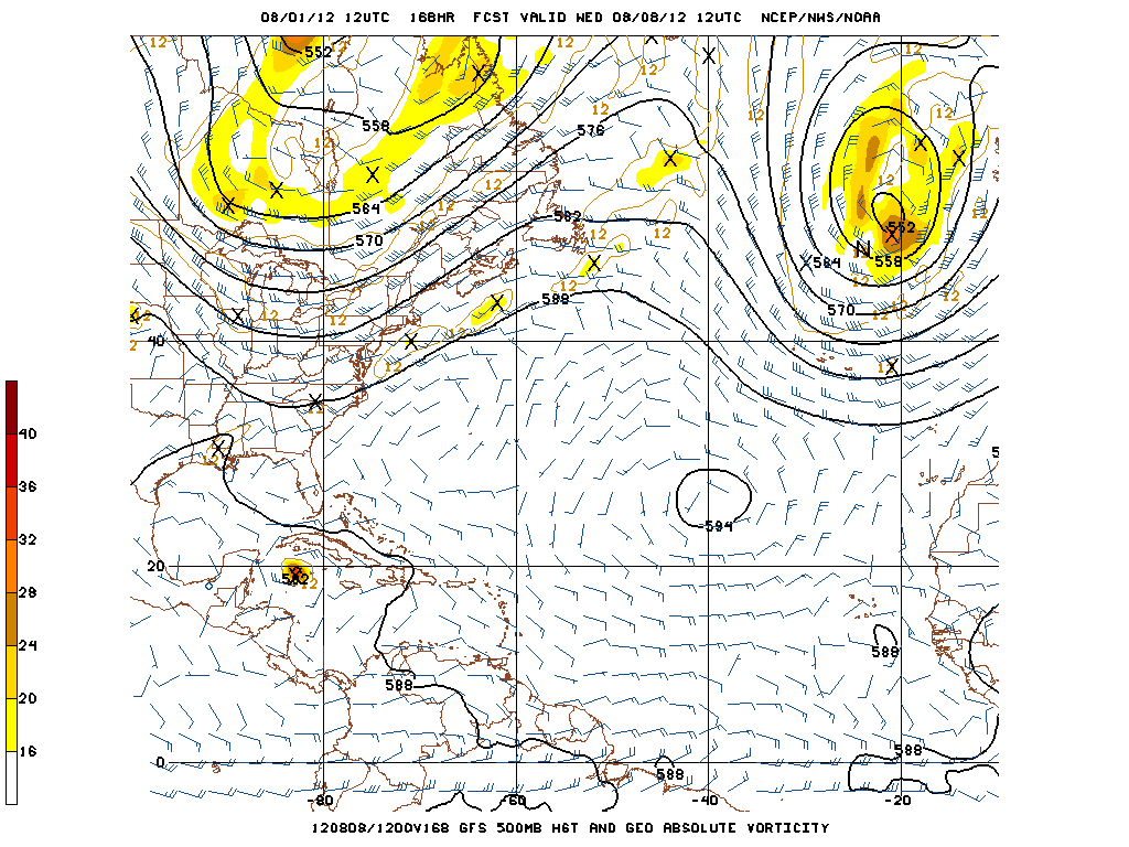
Can someone show me what they mean by an East Coast trough?
0 likes   
"People might not get all they work for in this world, but they must certainly work for all they get."- Frederick Douglass

RL3AO
Moderator-Pro Met
Moderator-Pro Met
Posts: 16308
Joined: Thu Jun 14, 2007 10:03 pm
Location: NC

Re: ATL: FIVE - Tropical Depression

#579 Postby RL3AO » Wed Aug 01, 2012 5:13 pm

AHS2011 wrote:Can someone show me what they mean by an East Coast trough?


Image

Question would be how much northerly turn can the trough over the NE/Canada cause.

NOTE: This is the gfs forecast for 7 days out. TD five seen near the Caymen Islands.
0 likes   

floridasun78
Category 5
Category 5
Posts: 3755
Joined: Sun May 17, 2009 10:16 pm
Location: miami fl

Re:

#580 Postby floridasun78 » Wed Aug 01, 2012 5:14 pm

ROCK wrote:18Z NOGAPS coming in...you can see it here....

https://www.fnmoc.navy.mil/wxmap_cgi/cg ... t=Tropical

it show td 5 going out to fish
0 likes   


Return to “2012”

Who is online

Users browsing this forum: No registered users and 5 guests